Since my last update on Monday, Tomas behaved pretty much as expected, and continues to do so. Copying directly from that update: "By later in the week, Tomas is forecast to regain hurricane status and very slowly make its way northward toward Haiti". Well, Tomas has become a hurricane again, and is currently near the tip of Haiti's southern peninsula. At 15Z, the intensity was 75kts/987mb and tracking NNE at 10kts. By far, the biggest concern with this storm is the very heavy rainfall over Haiti, eastern Cuba, and the Dominican Republic. There are many locations with Hurricane Warnings, please check http://www.nhc.noaa.gov/storm_graphics/AT21/refresh/AL2110W5+gif/ for the latest.
By early next week, Tomas will become entangled with a mid-latitude trough and become extratropical. But impressively, it's already been around as a numbered system for nearly 7 days, and probably will be around for another 3-4. My colleague Phil Klotzbach pointed out that "it would be the second most NSD [Named Storm Days] generated by a storm forming on or after October 29 since aircraft recon began in 1944. The most NSD generated by a single storm forming after October 29 is Hurricane Lili back in 1984, which generated an impressive 11.75 NSD". So, yet another anomaly for this incredibly active season that will go into the record books with the company of 1933, 1995, and 2005.
Please visit my tropical Atlantic headquarters.
05 November 2010
01 November 2010
Tomas weakens in the central Caribbean...
For a brief period early Sunday morning, Tomas reached an intensity of 85kts (Cat 2), but has since weakened significantly in the face of hefty vertical shear. In fact, the low-level circulation is completely exposed and the convection is displaced well to the east. As I write this, there is a resurgence of deep convection over the center, but it's still getting pushed off to the east. At 15Z today, the intensity is 40kts/1005mb (a weak tropical storm) and is forecast to remain weak for another day or so until the shear relaxes and the storm can regain its organization. By later in the week, Tomas is forecast to regain hurricane status and very slowly make its way northward toward Haiti.
Reaching the 19th named storm is extremely rare, but having a named storm in November is not so rare. In recent years, November storms include Ida '09, Paloma '08, Noel '07, Gamma '05, Delta '05, Otto '04, Nicholas '03, etc, etc, etc. The end of the official hurricane season is the end of November, but nature doesn't always obey that arbitrary limit... recent post-November storms include Olga '07, Epsilon '05, Zeta '05, Odette '03, and Peter '03.
Please visit my tropical Atlantic headquarters.
30 October 2010
Hurricanes Shary and Tomas bring a surge of activity to the end of October...
Shortly after recurving away from Bermuda, Shary intensified to a 65kt minimal hurricane and is still headed out to the hurricane graveyard that is the north-central Atlantic. This makes it the 11th hurricane of the season. It's 580 miles ENE of Bermuda and racing away from the island at 35kts. It is rapidly on its way to becoming an extratropical cyclone and will get absorbed into the mid-latitude westerlies.

As I suggested in my update yesterday, the disturbance near the Windward Islands was indeed upgraded to TS Tomas once the aircraft got there to investigate it. Then, today at 15Z, it was upgraded to Hurricane Tomas, the 12th of the season. The latest intensity is 65kts/993mb and on a very definite strengthening trend. It's crossing the Windward Islands as I type this, and will head into the Caribbean, quite likely bound to become the season's 6th major hurricane in the coming days. There is a long radar loop of the hurricane at bmcnoldy.rsmas.miami.edu/tropics/tomas10/Tomas_30-31Oct10.gif. Tomas is heading WNW at 13kts and this motion is expected to continue, bringing it near Jamaica in 5 days, probably as a major hurricane. All interests in the Caribbean should be watching this very closely. The latest watches, warnings, and track forecast can be found at http://www.nhc.noaa.gov/storm_graphics/AT21/refresh/AL2110W5+gif/
Please visit my tropical Atlantic headquarters.
29 October 2010
Shary forms far east of US coast, two other disturbances worth watching...
In a late-season surge of activity, there are three significant areas of tropical activity. The first of which was recently upgraded to TS Shary (03Z today), and is located about 950 miles due east of Jacksonville FL. This is the 18th named storm of the season. Intensity is estimated at 35kts/1004mb, and it is just about to begin recurvature to the NE... heading directly for Bermuda later tonight. Intensification will be limited due to the hefty vertical shear and cooling SSTs, so it's unlikely that Shary will become a hurricane. You can monitor Shary near Bermuda at http://www.weather.bm/radarLarge.asp
Elsewhere, an extremely well-organized easterly wave is nearing the Windward Islands. It existed the African coast on Oct 23 and has been quite impressive since then, particularly in the past couple of days. There is a 1006mb Low analyzed with the system, and a plane will be flying into it later today to gather more accurate intensity data. It's quite likely that this will be upgraded to TD 19 then TS Tomas within 24 hours. It's presently about 400 miles east of Trinidad and heading WNW toward the southern Windward Islands. Over the next several days, the eastern Caribbean environment will be favorable for significant development, so this could become the season's 11th hurricane. The Windward Islands, Virgin Islands, Puerto Rico, and Hispaniola should be very alert for possible impacts.
Finally, there's another area for potential development in the central Atlantic, about 1200 miles east of TS Shary. It also has its origins from an easterly wave that exited Africa back on Oct 19 (it's the one I mentioned in my update on Oct 21 when it was near the Cape Verde islands). Conditions are fairly hostile for this system to develop, but if it should, it would be TD22 then TS Virginie, assuming the previous system goes first.
Also assuming that Tomas forms from the disturbance nearing the Windward Islands, that would bring the season up to 19 named storms, a tie with the infamous 1995 season. 2010 is most certainly in the top 4 seasons in recorded history for activity, even if nothing else forms. As of today (not counting current or future developments), it has seen five major hurricanes, four of which were Cat 4, ten hurricanes, among the most ever recorded in a season, and 18 named storms, also among the the most ever recorded in a season!
Please visit my tropical Atlantic headquarters.
25 October 2010
Richard becomes season's 10th hurricane, hits Belize...
Over the weekend, Richard intensified to an 80kt Cat 1 hurricane prior to making landfall on Belize and tracking across the Yucatan peninsula. This was the 4th storm to hit that small section of coast (Alex, Karl, Matthew, Richard) this season. The radar loop of the storm's approach and landfall is at http://einstein.atmos.colostate.edu/~mcnoldy/tropics/richard10/Richard_24-25Oct10_belize.gif
At 15Z today, Richard was downgraded to a 30kt Depression and is still over the southern Yucatan peninsula. There will most likely be very little left of the vortex once it enters the Bay of Capeche, and all model guidance suggests a minimal TS or remnant low as it limps W-NW across the Bay.
With yet another hurricane added to the ranks, the rarity of such an active season not having a US landfall is even more striking. In the last 110 years, there has never been a season with 10 hurricanes and 0 US hurricane landfalls. You may recall that Ike was the last time the US was hit by a hurricane, and that was in early Sept 2008.
Please visit my tropical Atlantic headquarters.
22 October 2010
Richard nearly stationary east of Nicaragua...
Since yesterday's update, very little has changed. Richard is still a 35kt tropical storm, still forecast to head toward Belize and the Yucatan peninsula, and still forecast to become a hurricane prior to that first landfall. It's presently in a very weak steering environment, so it's drifting, most recently to the west at 3kts. Over the next two to three days, the forward motion should pick up as a ridge moves in to the north of it, sending it westward into Belize by Monday morning. I will have a full radar loop from Belize once the storm is within radar range, so stay tuned.
Depending on how intense it gets prior to that landfall, and how quickly it traverses the Yucatan peninsula, it will enter the southern Gulf of Mexico either as a remnant swirl or as a re-intensifying tropical storm. Given the magnitudes of those unknowns, any forecast beyond that is total speculation. To be on the safe side though, areas on the north and east US Gulf coast should be keeping a close eye on Richard next week.
The easterly wave that was near the Cape Verdes continues to look impressive on satellite imagery, but is not yet a Depression. It's still near the Cape Verdes, but moving toward the NW. It only has another 1-2 days to develop before it moves into much stronger vertical shear.
Please visit my tropical Atlantic headquarters.
21 October 2010
Richard forms in western Caribbean...
The area of disturbed weather that I mentioned in my last update 6 days ago has been festering and very slowly getting better organized. As several global models predicted about a week ago, a tropical storm has emerged from the southwestern Caribbean! At 03Z today, it was upgraded to TD19, then at 15Z today, upgraded again to TS Richard based on aircraft recon, making it the 17th named storm of the season. It's located about 200 miles ENE of the Nicaragua/Honduras border and the intensity is 35kts/1006mb. Since 1900, only three other seasons have had this many named storms: 1933, 1995, and 2005, so this is among the most active seasons in recorded history. Also, the name Richard has never been used before in the Atlantic, though it has been in the rotation for 30 years.
Richard is expected to continue strengthening as it heads slowly toward Belize and the Yucatan peninsula... the 5th storm this season to affect that area (Alex, Karl, Matthew, and Paula have already made their unwelcomed visits). The official forecast brings Richard to a Yucatan landfall (as a Category 1 hurricane) early on Monday morning, then enters the southern Gulf of Mexico by Tuesday morning. Beyond that, the states along the north and east Gulf coast (particularly Florida) should be watching this system closely.
Elsewhere, a surprisingly well-organized easterly wave has exited the African coast and is presently south of the Cape Verde islands and showing signs of a surface circulation. The shear and SSTs are currently not inhibitive for this to become a tropical cyclone in the next couple of days, but the environment does become more hostile after that.
Please visit my tropical Atlantic headquarters.
15 October 2010
Paula dissipates over Cuba...
Over the last couple of days, Paula skirted turned toward the NE, encountered significant shear, skirted along the northwest coast of Cuba, and just recently has the final advisory written on it as a dissipated Depression over central Cuba. Yet another landfall to add to the seasonal count, and yet another one that the US dodged.
With the assistance of my colleague Phil Klotzbach, I have a 159-year climatological probability of hurricane landfalls anywhere along the US coast. In seasons that are this active (as measured by the Net Tropical Cyclone activity, or NTC, which is currently 173.5 compared to an average season with NTC of 100), the US has a 95.4% chance of being hit by at least one hurricane of any category. Moving the threshold up to major hurricanes only (Cat 3+), the US has a 20.5% chance of being hit by at least one major hurricane. Clearly, the US coast has been quite fortunate so far this season.
Back to the current state of the tropics, there are hints of a tropical disturbance festering in the extreme southwestern Caribbean, over Panama. There is low-level convergence along the monsoon trough, some enhanced vorticity centered near Panama, and persistent convection also centered over Panama. In mid-October, those ingredients at that location is climatologically favored for a north-moving western Caribbean hurricane. In several long-range global models, a strengthening storm does emerge from this cocoon in the coming 3-4 days, then make its way generally northward toward Cuba in about 9 days.
Please visit my tropical Atlantic headquarters.
13 October 2010
Category 2 Hurricane Paula stalling in Yucatan Straights...
Aircraft recon into Paula on Tuesday afternoon found much stronger winds than expected, and it was immediately upgraded to an 85kt CAT2 hurricane with a central pressure of 981mb. Since then, it has has changed very little... at 15Z today the intensity is 85kts/984mb. Though the forecast is for gradual weakening in the face of increasing vertical shear, a short-term temporary increase is possible based on satellite imagery. There is another recon plane en route to the storm as I type this, so in a couple of hours we will know better what the exact intensity is. It's a rather small storm, so changes (either increases or decreases) can happen dramatically.
Looking at the long radar loop available at http://einstein.atmos.colostate.edu/~mcnoldy/tropics/paula10/Paula_12-13Oct10.gif, you can see that the motion has slowed down quite a bit, and is now drifting to the NE at roughly 3kts. The forecast track is for continued slow motion, and turning to the E, then dissipating over the mountains of Cuba. However, there is large model guidance spread, and anything from completely stalling in the Yucatan Straights for a few days to getting picked up by the trough and heading NE over Cuba/Florida/Bahamas is within the realm of possibilities. If you are in any of those areas, you can keep up to date on the latest watches and warnings at http://www.nhc.noaa.gov/refresh/graphics_at3+shtml/144014.shtml?5day#contents
Please visit my tropical Atlantic headquarters.
12 October 2010
Hurricane Paula heading for the Yucatan...
A lot has happened in 24 hours... the disturbance that was off the Nicaragua/Honduras border rather quickly got better organized. A plane flew into the system and found much stronger winds than expected, and at 21Z yesterday, it was upgraded to TS Paula with 50kt winds and a 1000mb central pressure. Just 12 hours later, it was upgraded to Hurricane Paula, the 9th of the season. The intensity as of 15Z today is 65kts and 991mb, and it's located 150 miles SSE of Cozumel, Mexico and heading NNW at 9kts. Hurricane warnings are in effect for the eastern coast of the Yucatan Peninsula: http://www.nhc.noaa.gov/storm_graphics/AT18/refresh/AL1810W_NL+gif/
It is forecast to continue intensifying, and also to slow down. In 5 days, it is forecast to be in the Yucatan Straights, not far from where it is now. However, increasing shear is expected to hit it in about 3 days, so it might not make it to a major hurricane.
You can monitor its structure and movement via a radar loop from Cancun: http://einstein.atmos.colostate.edu/~mcnoldy/tropics/paula10/Paula_12-13Oct10.gif
Please visit my tropical Atlantic headquarters.
11 October 2010
Otto becomes extratropical, disturbance brewing in western Caribbean...
Otto spent 1.5 days as a hurricane, though was visibly losing its tropical characteristics in a hurry (weaker and displaced convection, frontal bands, etc.). At 03Z on Sunday, it was downgraded to a TS, then twelve hours later, advisories were ceased on the system as it became an extratropical cyclone about 400 miles west of the Azores.
There is a 1008mb Low associated with a disturbance that has been festering in the western Caribbean for several days (I mentioned it in my update on Friday). It's currently located on the tip of the Nicaragua/Honduras border and drifting to the WNW. The majority of models gradually develop this system into a TS (Paula) as it heads NW toward Cozumel, then recurving to the NE toward Cuba/Florida. Intensification should be somewhat limited due to the expected proximity to land throughout the next few days.
Please visit my tropical Atlantic headquarters.
08 October 2010
Hurricane Otto heading out to the north central Atlantic...
Since my last update on Tuesday, the disturbance I referenced was upgraded to STD17 on Wednesday morning, STS Otto on Wednesday afternoon, TS Otto on Thursday morning, and now Hurricane Otto as of 15Z today. Sorry about the lack of updates since Tuesday!
The storm took a while to get organized and acquire purely tropical characteristics, and as such, it was sub-tropical for at least a couple of days. As I write this, it definitely is tropical, and has a rather impressive satellite presentation with nearly -85C cloud tops in the CDO. There is not yet an eye apparent in the VIS or IR, but that could certainly change in the coming hours.
The current intensity is 65kts and 979mb, making Otto the 8th hurricane of the season. Right now, we're just one TS away from matching the active 2008 season which had 16 named storms, 8 hurricanes, and 5 major hurricanes. The storm is located about 550 miles north of Puerto Rico and tracking ENE at 15kts. The forecast is for some additional strengthening, then a rapid transition to extratropical as it merges with a mid-latitude trough which will whisk the system out to the north central Atlantic over the next 3 days.
Elsewhere, there's a low-level swirl associated with an easterly wave located north of Panama. This doesn't look too likely to develop in the foreseeable future.
Please visit my tropical Atlantic headquarters.
05 October 2010
Disturbance near Windward Islands getting organized...
Back on Sept 25, an easterly wave exited the African coast and has been making its way westward through the deep tropics. For much of the last 1.5 weeks, it has been a feature of interest, but not great interest. In the past couple of days however, the circulation and convection have become more concentrated, and the system is now just north of Puerto Rico. Using the long-range radar from San Juan, we can see the weak circulation: http://radar.weather.gov/radar.php?rid=JUA&product=N0Z&overlay=11101111&loop=yes.
It's in about 10kts of vertical shear (expected to decrease slightly over the next couple of days) and over 29C water (remaining steady over the next couple of days). The majority of models now develop this system, bringing it to TS intensity within a day, and hurricane intensity in 2-4 days. As far as the track goes, models are in agreement that it will recurve out to the open ocean in about 2 days... drifting to the NW prior to that.
The next name on the list is Otto.
It's truly remarkable that the US has not had a hurricane landfall this season... it's been quite an active season so far, with 14 named storms, 7 hurricanes, and 5 major hurricanes. But, countries to our south haven't been so fortunate. It's been a very bad year for landfalls and tropical cyclone effects in most of central America and Mexico... also Bermuda and Newfoundland had noteworthy, historic encounters.
Please visit my tropical Atlantic headquarters.
30 September 2010
Nicole dissipates, easterly wave getting organized...
Since my update on Tuesday, TD16 was briefly upgraded to TS Nicole, then Nicole rapidly lost its tropical characteristics and merged with a mid-latitude trough... before even reaching Florida! This was a very unusual situation, and is resulting in a very unusual heavy rain event up the entire US east coast. Everywhere from FL to ME and from the coast to hundreds of miles inland, flooding rains are the big story.
See http://www.weather.gov/largemap.php for a real-time summary of the watches and warnings associated with this event, and http://www.hpc.ncep.noaa.gov/discussions/nfdscc5.html for a history of what has fallen so far in select locations.
Elsewhere, there's a broad circulation associated with an (possibly 2 really close) easterly wave located about 800 miles east of the Windward Islands. Though not widely favored by global models for development, it looks fairly impressive on satellite imagery.
Please visit my tropical Atlantic headquarters.
29 September 2010
Lisa and Matthew are out of the picture, TD16 forms...
During the last three days since my last update, Lisa and Matthew fizzled out (Lisa drifted north over cold water in the far eastern Atlantic and Matthew dumped ridiculous amounts of rain over much of central America and dissipated inland), and a new large area of disturbed weather has been brewing over the western Caribbean... perhaps the one that many of the global models hinted at over a week ago.
That disturbance was upgraded to TD16 today at 15Z based on satellite and surface observations... and a recon aircraft just took off for a flight into the system as I type this. The intensity estimate is 30kts and 1001mb; it's located about 180 miles S of Havana and tracking NNE at 9kts. It is forecast to slowly intensify and head NNE, bringing it over Cuba then into south Florida most likely as a TS. There are Tropical Storm Warnings for central Cuba, the Bahamas, and the Florida peninsula from Key West to West Palm Beach. The next name on the list is Nicole.
For a little bit of hurricane history, on this day 12 years ago, large and tenacious Hurricane George made landfall near Biloxi, MS as a CAT2 storm: http://upload.wikimedia.org/wikipedia/commons/d/d0/Hurricane_Georges_28_sept_1998_2043Z.jpg
Please visit my tropical Atlantic headquarters.
23 September 2010
Lisa downgraded to TD, disturbance in southern Caribbean getting better organized...
Lisa has been plagued by a hostile environment with moderately strong vertical shear and moderately dry low-mid level air... a bad combination if you're a tropical cyclone. As a result the storm was downgraded to a Depression at 09Z today, and remains so at 15Z. However, there is a 1-2 day window of opportunity beginning now where the environment should improve before drier air invades again. Regardless, Lisa will remain a weak storm and far from any land.
On the other hand, that area of disturbed weather that was skimming the Venezuelan coast the past couple of days is now located north of western Columbia and heading west toward Nicaragua. The environment in which this system is embedded couldn't be any more conducive for significant development: 30C SSTs, 5 kts of vertical shear, and huge values of ocean heat content. Though it has taken nearly a week to get spun up (not out of the norm), it appears that it is now nearly a Depression and could quickly intensify to TS Matthew. As I mentioned before, a system like this must be watched very closely, because it WILL affect land, and probably have 1-3 landfalls in its lifetime. I've been perusing the global model output regularly, and an overall trend and consensus is to bring the storm gradually WNW through much of the western Caribbean, then perhaps a NW turn to bring it up into the Yucatan Straights area by the middle of next week.
A recon plane left St. Croix early today and is conducting multiple penetrations through the system as I type this. So far, a central pressure of 1008mb has been found, along with 36kt flight-level winds (corresponds to nearly tropical storm force at the surface).
Please visit my tropical Atlantic headquarters.
21 September 2010
Igor racing by Newfoundland, Lisa forms in eastern Atlantic, disturbance crossing Windward Islands...
Igor is still officially a hurricane, though is in the midst of its extra-tropical transition. Storms like this that are over very cold SSTs (15F) and in 50kts of vertical shear can still be very powerful thanks to baroclinic enhancement. The same trough that's steering and shearing it is providing an energy transfer to the dying [formerly-barotropic] hurricane. Here's one model's (HWRF) representation of an along-shear vertical cross-section of the storm showing a barely barotropic structure: http://einstein.atmos.colostate.edu/~mcnoldy/tropics/hwrf/2010/plots/AL11/2010AL11_HWRFXSEC_201009210600_F000.PNG
At 15Z, Igor's intensity was 65kts, 952mb, and cruising by Newfoundland at 40kts. It probably has another 6-12 hours remaining as a system that NHC tracks. It has been a hurricane for nearly 10 days and using NTC as a measure of seasonal activity, has provided ~40% of a typical season's entire activity by itself (NTC is Net Tropical Cyclone activity which combines the numbers and longevities of the various storm intensities --TS, H, MH-- and compares them to climatology)!
At 03Z today, the easterly wave in the far eastern Atlantic was upgraded to TD14, then six hours later, to TS Lisa, the 12th named storm of the season. It's located about 530 miles WNW of the Cape Verde islands, and drifting to the north. It is forecast to continue drifting to the north, and only intensify slightly, probably never reaching hurricane status and never affecting any land.
Back on the 16th, I mentioned a "suspicious surge of southwesterlies" about 1700 miles east of the Lesser Antilles. Well, it has indeed festered for a few days, and is now a fairly impressive disturbance located just north of the central Venezuelan coast. Conditions are favorable for further (and significant) development, so this will be watched very closely. The next name on the list is Matthew.
Please visit my tropical Atlantic headquarters.
20 September 2010
Igor passes close to Bermuda, new disturbance in eastern Atlantic...
Hurricane Igor made its closest to Bermuda right around midnight local time as forecast. A peak wind of 81kts was reported on the island, and the minimum pressure at that time was 955mb. The radar loop showing the approach is here: http://einstein.atmos.colostate.edu/~mcnoldy/tropics/igor10/Igor_19-20Sep10.gif (the radar and/or network was down on Bermuda as the eyewall neared, so the loop cuts off just prior to closest approach).
At 15Z today, the intensity was 65kts (minimal hurricane) and 960mb. Tropical storm force winds extend 300 miles to the NE and NW of the center, and 12' seas extend out to 800 miles from the center in the southwest quadrant. A tropical storm warning is now in effect for eastern Newfoundland, but by Tuesday morning, the long-lived (12 days) powerful hurricane will begin its extra-tropical transition as it merges with a mid-latitude trough.
The final advisories were written on Karl and Julia on Saturday 09Z and Monday 15Z, respectively.
The easterly wave that I mentioned on Friday has continued to get better organized and now has a 1007mb Low associated with it. It's located about 450 miles west of the Cape Verde islands and drifting to the NW. There's also an easterly wave right on the African coast. Both of these will be watched closely, and the next names are Lisa and Matthew.
Please visit my tropical Atlantic headquarters.
17 September 2010
Igor, Julia, and Karl still all hurricanes, Karl becomes 5th major hurricane...
Igor is still holding onto major hurricane status (it's been 5 days now) with winds of 105kts and a 945mb central pressure. It's an extremely large storm, with tropical storm force winds extending 250 miles from the center on the front-left quadrant, and hurricane-force winds extending 90 miles out in the same quadrant. It continues to slowly make it way toward Bermuda, and a closest approach is still forecast to take place Sunday night into Monday morning... Bermuda now has a hurricane watch in effect. You can monitor weather conditions at Bermuda here: http://www.ndbc.noaa.gov/show_plot.php?station=bepb6&meas=wdpr&uom=E&time_diff=-4&time_label=EDT and there's a radar loop available here: http://einstein.atmos.colostate.edu/~mcnoldy/tropics/igor10/Igor_19-20Sep10.gif
Julia has been slow to weaken, but is now estimated to be 75kts and 981mb. It's been moving quite a bit further west than expected, and the relatively tiny storm is only about 800 miles due east of Igor and it's huge circulation. The forecast is for continued weakening and a turn to the NW then recurving by 55W.
2010 is shaping up to be quite a historic season... during the overnight hours, Karl rapidly intensified to 105kts, making it the fifth major hurricane of the season, and the furthest south a major hurricane has ever existed in the Gulf of Mexico. It also made a turn to the WSW, steering it directly into the city of Vera Cruz (Mexico's oldest and largest port with a population of ~ 700,000 and 490 years of history). The city has never experienced a major hurricane, so this will probably be quite destructive and worthy of retiring the name Karl (which has been in rotation since the beginning of naming hurricanes)! Only 3 other "K" storms have been retired: Klaus '90, Keith '00, and Katrina '05. As I type this message, Karl is making landfall with an intensity of 105kts and a central pressure of 967mb. Not only will the powerful winds be destructive, but flooding rains (up to 15" forecast) and a significant 12-15' storm surge. There is a radar loop of Karl here: http://einstein.atmos.colostate.edu/~mcnoldy/tropics/karl10/Karl_16-17Sep10.gif showing an eyewall replacement cycle, subsequent eyewall contraction, and landfall.
An educational tidbit can be gathered from Igor and Karl: they are both 105kt storms (as verified by aircraft) yet Igor is about 4 times larger than Karl. With tropical cyclones, it's important to realize that size and intensity are not related. Another contrast is Katrina '05 and Andrew '92... at landfall, Andrew was quite a bit stronger than Katrina (Cat5 vs Cat3), but was a fraction of the size. I cannot resist the opportunity to use a memorable quote from Yoda in Star Wars (Empire Strikes Back): "Size matters not. Look at me. Judge me by my size, do you? And well you should not, for my ally is the Force, and a powerful ally it is."
The area I described yesterday with a surge of southwesterlies continues to look interesting, and more global models are beginning to pick up on possible tropical cyclone formation from it. This area is at about 10-15N and 35-40W.
There's also a potent easterly wave that recently exited the African coast and is now located near the Cape Verde islands. This will be watched closely in the coming days for development as well. The next names on the list are Lisa and Matthew.
Please visit my tropical Atlantic headquarters.
16 September 2010
Three simultaneous hurricanes
From Phil Klotzbach:
With Karl becoming a hurricane, we have three hurricanes at the same time. This is a pretty rare occurrence. The only other years that this has occurred are 1893, 1926, 1950, 1961, 1967, 1980, 1995, and 1998. 1998 even had four hurricanes at the same time! For those that are interested, the time periods with three hurricanes are as follows:
Please visit my tropical Atlantic headquarters.
With Karl becoming a hurricane, we have three hurricanes at the same time. This is a pretty rare occurrence. The only other years that this has occurred are 1893, 1926, 1950, 1961, 1967, 1980, 1995, and 1998. 1998 even had four hurricanes at the same time! For those that are interested, the time periods with three hurricanes are as follows:
August 17, 1893 00Z – August 24, 1893 12Z
September 12, 1926 12Z – September 14, 1926 00Z
August 31, 1950 00Z – August 31, 1950 06Z
September 2, 1950 12Z – September 4, 1950 18Z
September 7, 1961 00Z – September 12, 1961 06Z
September 10, 1967 06Z – September 11, 1967 00Z
September 12, 1967 00Z – September 12, 1967 06Z
September 14, 1967 12Z – September 16, 1967 06Z
September 8, 1980 06Z – September 8, 1980 18Z
August 30, 1995 18Z – August 31, 1995 12Z
September 23, 1998 18Z – September 27, 1998 18Z
Please visit my tropical Atlantic headquarters.
Igor heading for Bermuda, Julia weakening, Karl heading for Mexico a second time... And another worthy headline: three simultaneous hurricanes in the Atlantic!
Igor has not dropped below the CAT4 threshold, and is presently a 120kt storm with a central pressure of 934mb. It is located 910 miles SSE of Bermuda and heading NW at 6kts. It is forecast to maintain major hurricane status through Monday when it begins recurving and interacting with a mid-latitude trough.
The attached file shows the latest suite of model forecasts of Igor's track. There is very little spread among the models, indicating a greater deal of certainty in the forecast. Though not shown on that map, the closest approach occurs 90-96h from the 06Z initialization, which is late Sunday night into early Monday morning. I will make a running radar loop (real-time, accumulating frames) and provide a link to it as the time gets closer.

Julia has entered a more hostile environment as expected, and has weakened... the satellite presentation is much worse today than it was yesterday. As such, the intensity is down to 85kts and 971mb. It is in the open eastern Atlantic, far from anything, and will continue to weaken in the face of increasing vertical shear.
Karl made landfall on the Mexico/Belize border as a 55kt tropical storm, and was barely phased by the flat terrain of the Yucatan peninsula. It exited the peninsula in the early morning hours on Thursday and was very quick to regain its organization. At 15Z today, it was upgraded to a hurricane, the sixth of the season, and is forecast to continue intensifying, perhaps nearly to a major hurricane, before it makes its second and final landfall near Poza Rica on Friday evening. Hurricane Watches and Warnings are in effect, and you can see the latest here: http://www.nhc.noaa.gov/storm_graphics/AT13/refresh/AL1310W5_NL+gif/. The current intensity is 65kts and 983mb and increasing fairly rapidly.
Elsewhere, there is a suspicious surge of southwesterly winds in the area of 5-10N, 30-40W (about 1700 miles east of the Lesser Antilles) and some scattered deep convection associated with the resulting convergence. If that festers for a few more days, a low-latitude tropical disturbance could be in the cards. Something worth keeping an eye on in the coming days, since low-latitude systems are much less likely to recurve before reaching the US.
I'll dedicate today's update to my grandfather, James McNoldy, who passed away this past February, but would be 94 today. He once told a story of his WWII assignment (maintaining and repairing aircraft in Iceland) and the intense storms they'd get there. Once in a while, the remnants of a tropical cyclone make their way up to Greenland, the UK, Portugal, and Iceland, and if you're on an airfield fixing aircraft, you'd notice things like that!
Please visit my tropical Atlantic headquarters.
15 September 2010
Igor and Julia both CAT4 hurricanes, Karl forms and hits Yucatan...
Igor is still heading WNW and is still a Category 4 hurricane (has been since Sunday afternoon!). The 15Z intensity is 115kts and 942mb, but there was a nighttime intensification period during which it reached 135kts and 925mb... the strongest of its lifetime. It's located about 1055 miles SE of Bermuda and heading WNW at 7kts. In the coming days, Igor's intensity will likely fluctuate but remain very strong, and the track will bend a bit more to the NW. This will bring the hurricane very close to Bermuda by Sunday morning.
Tuesday evening, Julia experienced a period of rapid intensification where the pressure fell 24mb in 6 hours and the wind speed increased 25kts in the same time. As of 15Z, the intensity is 115kts and 950mb. This makes it the forth Category 4 hurricane of the season, and the easternmost CAT4 hurricane on record. Never in recorded history has there been four CAT4 storms so early in the season (we've had Danielle, Earl, Igor, and Julia all by Sept 15). It is also only the second time that two CAT4 storms have existed at the same time (the other time was in 1926). So Julia has certainly become a storm for the record books, as has the 2010 season!
The disturbance that has been tracking through the Caribbean was upgraded to TS Karl at 21Z yesterday based on an aircraft recon flight into the system. Since being named, it quickly intensified to a 55kt storm, and is now inland near the Mexico/Belize border heading W at 12kts. At this rate, it should enter the Bay of Campeche in the early morning hours (local) tomorrow, perhaps as a Depression. It is then forecast to regain TS status and head W into Mexico and make its final landfall early Saturday morning as a TS.
This is old news now, but I thought I'd share a high-resolution visible satellite loop that I made of Igor as a CAT4 on Sep 13 using 1-minute imagery: http://einstein.atmos.colostate.edu/~mcnoldy/tropics/igor10/goes15_ch1_20102562045.swf
Please visit my tropical Atlantic headquarters.
14 September 2010
Igor and Julia now both hurricanes, no threat to land...
Igor has weakened slightly to 115kts/945mb, but is still a powerful Category 4 hurricane. During the night, the storm finally made a turn to the WNW, which models have been hinting at for a few days, but the storm wasn't doing it. Assuming this motion continues, this confirms that the storm is feeling the weakness in the subtropical ridge and will continue to turn toward it. Igor is expected to remain a major hurricane at least through this week. The primary land at risk is Bermuda, which could feel the worst of the storm late this weekend.
At 09Z today, Julia was upgraded to the 5th hurricane of the season. In an average season, the 5th hurricane would form around October 7, so we're certainly seeing an active season (the 2nd major hurricane hurricane would climatologically form around October 3, and we've already had 3!). At 15Z, the intensity was estimated at 75kts with a central pressure of 984mb. As is typical for pressures ~985mb, an eye is forming, and Julia is expected to strengthen more, until it hits higher vertical shear in a day or so. It's currently located about 355 miles WNW of the Cape Verde islands and heading WNW at 9kts.
The disturbance that was south of Jamaica yesterday is still not a Depression, and is located south of Isla de la Juventud, Cuba. The appearance continues to improve, and could become a Depression later today. There is a 1006mb Low associated with the disturbance, and the majority of forecast models intensify it to a TS prior to hitting the Yucatan, maintain or slightly weaken it during the crossing, then re-intensify it to a strong TS or weak hurricane as it traverses the Bay of Campeche. Landfall on mainland Mexico is expected on Saturday, assuming a storm actually forms. The next name is Karl.
Please visit my tropical Atlantic headquarters.
13 September 2010
Igor now a CAT4 hurricane, Julia forms in far eastern Atlantic...
Since my previous update on Saturday morning, Igor has become a very powerful Category 4 hurricane, with 130kt winds and a 933mb central pressure. The bulk of the intensification occurred on Sunday, when the pressure fell from 970mb to 942mb in 6 hours (and a corresponding increase in wind speed from 90kts to 120kts). Impressively, it has maintained Cat 4 status for a day now, and isn't showing signs of weakening yet. It's located about 880 miles east of the Leeward islands and heading W at 9kts. The forecast models have consistently been indicating a more NW turn in the track, which so far hasn't happened... in fact, it has been moving slightly south of west over the last 12-18 hours, which only one model (NOGAPS) was predicting. All models, even that one, are now showing a WNW-NW turn beginning almost immediately. There is quite a bit of model variance beyond 3 days, but it also isn't going to affect land any time in the near future.
The strong easterly wave that exited Africa on Saturday was promptly upgraded to TD12 then TS Julia (it was numbered at 21.4W, two degrees east of the easternmost Cape Verde islands... VERY far east!). It is currently located south of the westernmost Cape Verde islands, and the intensity is estimated at 35kts/1004mb. The forecast is for gradual strengthening, probably becoming the season's 5th hurricane, and for a NW turn in the track, taking it into the central Atlantic by 5 days.
The area of disturbed weather that was in the eastern Caribbean on Saturday has not gotten much better organized and is now south of Jamaica. It still has a chance to become a tropical cyclone in the coming days, as it's in a rather favorable environment. The track, if it forms, would be generally WNW into the Yucatan Peninsula then the mainland Mexican coast by the weekend. The next name on the list is Karl.
Please visit my tropical Atlantic headquarters.
11 September 2010
Igor heading west, still a tropical storm...
Tropical Storm Igor has gone through a few oscillations between sparse and healthy convection, but has maintained a vigorous low-level circulation. As of this writing, the deep convection is located over the center and is fairly symmetric. It appears to be taking advantage of an improving environment and is on its way to becoming the season's 4th hurricane. It's located about 1400 miles east of the Leeward Islands and heading W at 17kts. At 15Z, the intensity was estimated at 60kts and 995mb. The long-range forecast is for Igor to continue heading west, then make a gradual WNW bend by the middle of next week as it passes north of the Leeward Islands.
Two other disturbances are worth watching in the coming days: one in the far eastern Caribbean and one right on the African coast. Both of them are likely to become named storms in the coming days, and the next names are Julia and Karl. The easterly wave that is exiting the African coast is incredibly well-developed and could even be a numbered/named system before reaching the Cape Verde islands!
Also of note: today is the 50-year anniversary of Hurricane Donna's landfall on Florida (Category 4), and Hurricane Iniki's landfall on Hawaii (Category 4).
Please visit my tropical Atlantic headquarters.
09 September 2010
Igor maintains intensity, easterly wave crossing Windward Islands...
Igor is drifting around the Cape Verde islands in very weak steering, and the latest heading estimate is NNW at 5kts, but a general motion to the WNW is expected in the longer term. The deep convection is persistent, but not located over the surface circulation due to the rather strong (~25kts) vertical shear. However, the shear is forecast to drop drastically to about 5kts within the next couple of days and Igor should intensify and become the season's 4th hurricane. At 15Z, the intensity was 35kts and 1006mb. This storm is just off of Africa, so it will be a week or longer until it could even reach the Lesser Antilles, and much longer for any potential US encounter. Here is a map from Jeff Masters showing all past tracks taken by storms in the same location: http://icons-pe.wunderground.com/data/images/at201011_climo.gif
The easterly wave near the Windward Islands continues to get better organized, and is centered very close to Grenada (Grenada suffered catastrophic damage from Hurricane Ivan on Sep 7, 2004 and has barely recovered from that devastation). Luckily, this disturbance is nothing like Ivan, but will still bring flooding rains and perhaps tropical storm force winds to the area. Although poorly organized now, it must be watched very closely because the environment is quite favorable for significant development and forecast track scenarios for a storm in this location inevitably involve at least one landfall. The next name on the list is Julia.
I'd like to thank once again my guest writers during the past week, Kate Musgrave and Gus Alaka. I've heard from some of you that you were quite appreciative to keep receiving these updates in my absence!
Please visit my tropical Atlantic headquarters.
08 September 2010
Hermine dissipating, Igor forms in the far eastern Atlantic...
From Gus Alaka:
Tropical Depression Hermine (20 kts, 1005 mb) is located in central
north Texas and is bringing heavy rains to much of the state.  Most of
the heavy rain occurred to the east of the center, as the onshore flow
helped feed moisture into the system.  Much of the region received 3"+
of rain from 12Z yesterday to 12Z today.  A few isolated areas (near
Austin, TX) received 10"+ during the same time frame.  Hermine should be
extratropical by tonight.

1-Day Rainfall - Texas
<http://water.weather.gov/precip/save.php?layer%5B%5D=0&layer%5B%5D=1&layer%5B%5D=4&timetype=RECENT&loctype=STATE&units=engl&timeframe=current&product=observed&loc=stateTX>


****************************************

A vigorous tropical wave moved off the African coast yesterday.  This
system maintained deep convection and the circulation became better
defined.  Thus, Tropical Storm Igor, the 9th named storm of the 2010
Atlantic hurricane season, formed in the far eastern Atlantic,
approximately 95 miles SE of the southern Cape Verde Islands.  The
initial intensity is set to (35 kts, 1005 mb) and it is currently moving
W at 7 kts.  Igor is the 2nd tropical storm to form without first being
a tropical depression (Colin was the other).  Presently, tropical storm
watches are out for the southern Cape Verde Islands of Maio, Sao Tiago,
Fogo, and Brava.

Igor's forecast calls for slow strengthening over the next couple of
days, with an increase in motion as it moves generally to the W.  NHC
has Igor becoming a hurricane in 72 hours, which is slower than some of
the models, due to the presence of vertical wind shear.  Igor is
forecast to turn to the WNW in a few days in response to a weakness in
the subtropical ridge.  However, if the ridge does not weaken as
forecast, Igor could be of interest to the Leeward Islands in a week or
so, but let's not get ahead of ourselves.

****************************************
OTHER FEATURES

The remnants of Gaston continue to race through the Caribbean.  Although
convection is present with the system, it is quite disorganized.  Models
do not call for the redevelopment of this system.
Please visit my tropical Atlantic headquarters.
07 September 2010
Earl makes landfall in Nova Scotia, Fiona dissipates, Hermine makes landfall in Mexico as a TS, remnants of Gaston entering the Caribbean, west African coast active again...
From Gus Alaka:
Earl weakened from a Cat. 1 hurricane to a tropical storm and passed
about 90 miles SSE of Nantucket Island, Massachusetts.  Most of the
nasty weather associated with Earl was located to the east of the
center, which allowed SE Massachusetts to escape mostly unscathed.
Nantucket Island experienced gusts to about 55 mph and a few inches of
rain.  Earl continued to race to the NE and made landfall at Western
Head, Nova Scotia at 14Z on Saturday with (60 kt, 962 mb).  With a large
wind field, much of the province experienced strong tropical storm force
winds and heavy rain.  However, Earl had already begun an acceleration
to the NE and did not linger long enough to cause any serious damage.
However, Maritime Electric reported that 9400 Nova Scotian homes were
without power at one point during the storm.  Earl quickly raced into
the Gulf of Saint Lawrence, where it was pronounced extratropical at 3Z
on 9/5.

Fiona continued to weaken and bear down on Bermuda late last week.
However, the unfavorable environmental conditions got the best of the
system, and Fiona degenerated into a remnant low before reaching
Bermuda.  At the last advisory, Fiona was only 60 miles south of
Bermuda.  The island likely experienced some gusty winds and isolated rain.

TD10 formed in the SW Gulf of Mexico late Sunday evening.  By Monday
morning, TD10 intensified into Hermine, the 8th Atlantic tropical storm
of 2010.  Moving generally to the NNW, Hermine intensified from (35 kt,
1001 mb) at 9Z to (55 kt, 991 mb) at 0Z.  Hermine was still intensifying
at landfall, and if the track had been slightly more N (rather than
NNW), Hermine may have had a chance to become the 4th hurricane of the
Altantic basin.  Hermine has since moved inland and will bring heavy
rains (4"-8") and flooding to south Texas as the center moves to the N
at ~15 kts.  Hermine, still a minimal tropical storm, is forecast to
continue weakening and should be a tropical depression at the next
advisory.

I was able to find this Doppler Radar image of Hermine at landfall:

There are no other named storms or depressions in the Atlantic.
However, there are a few features of interest.

The remnant low of Tropical Storm Gaston is entering the NE Caribbean.
There has been some convection associated with the remnant low, although
NHC does not expect further development from this system.  To provide
more support to NHC's assertion, a number of models (GFS, ECMWF,
GFDL...) do not redevelop Gaston either.  Nonetheless, this system will
be monitored for any signs of organization.

A potent tropical wave has just exited the west African coast.  It will
be monitored for development as it travels W.
Please visit my tropical Atlantic headquarters.
03 September 2010
Earl passes close to US coast...
From Kate Musgrave:
Hurricane Earl passed east of NC early this morning as a Category 2 hurricane, before weakening further to a 75kt/961mb Category 1 hurricane at the 15Z advisory. Earl is currently located about 175 miles NE of Cape Hatteras, NC, or about 350 miles SSW of Nantucket, Mass. Earl continues to move NNE at 18kt and is expected to approach Cape Cod tonight as a hurricane, and reach Nova Scotia, Canada as a tropical storm tomorrow morning, before going extratropical in about 36 hours. Hurricane warnings remain in effect for parts of the Mass coast, with hurricane watches for parts of the southern coast of Nova Scotia. Tropical storm warnings range from NC to NJ, and parts of Long Island through portions of Mass, with tropical storm watches and warnings posted in Maine, New Brunswick and Nova Scotia. While Earl has weakened significantly, from 120kt to 75kt in 24 hours, the area covered by tropical storm strength winds is extensive, up to 205 miles from the center of the system.
Tropical storm Fiona has continued to recurve and weaken as it approaches Bermuda. As of 15Z it is 40kt/1010mb, moving NNE at 11kt. Fiona is expected to continue its weakening trend, dissipating within 3 days. It's center should pass closest to Bermuda in about 18 hours.
Tropical depression Gaston continued to weaken yesterday, dropping from a depression to a remnant low. The area will be monitored for possible redevelopment over the next few days. It is still expected to move to the W/WNW, approaching the Lesser Antilles in about a week.
Please visit my tropical Atlantic headquarters.
02 September 2010
Earl approaching NC coast, Fiona turning towards Bermuda, Gaston is named...
From Kate Musgrave:
Hurricane Earl has re-strengthened into a Category 4 hurricane, with its intensity at 15Z estimated at 120kt/932mb. Hurricane warnings continue on the NC coast and have been issued for parts of the Mass coast. Hurricane watches extend from the NC/VA border up through DelMarVa peninsula. Tropical storm warnings extend from the NC/VA border up to Mass, with tropical storm watches for parts of Long Island and extending from Mass up through Maine and parts of Nova Scotia, Canada. It is expected to weaken in intensity as it approaches the North Carolina coast, but still be a major hurricane at its closest approach overnight tonight/early Friday morning. Earl is expected to then accelerate and turn towards the NE, bringing it close to Mass by Friday night and then approaching Nova Scotia Saturday.
Tropical Storm Fiona has weakened slightly over the past day, and begun turning more to the N. As of 15Z it is estimated at 45kt/1002mb, moving NNW at 15kts. Fiona is expected to continue recurving to the N and NE, heading towards Bermuda. Tropical storm warnings have been posted for Bermuda. Fiona continues to deal with a much less favorable environment than Earl's, and the official forecast continues weakening Fiona before dissipating it in 4 days.
TD9 strengthened into Tropical Storm Gaston yesterday at 21Z, before dropping back down to a depression at 15Z today. It is currently about 1600 miles east of the Lesser Antilles and has slowed its forward motion. As of 15Z it is estimated at 30kt/1008mb, heading WNW at 6kts. It is expected to track WNW over the next several days and is still a week away from the Lesser Antilles, with the majority of models bringing it to hurricane intensity within that time.
Please visit my tropical Atlantic headquarters.
01 September 2010
Earl still heading toward NC coast, Fiona affecting Leeward Islands, TD9 forms...
Earl has weakened very slightly, and just happened to cross the Cat 3-4 threshold to 110kts (943mb central pressure). It's currently located about 725 miles SSE of Cape Hatteras, NC and heading NW at 14kts. Hurricane Warnings now cover all of the NC coast and Hurricane Watches cover the southern parts of the VA coast and the DelMarVa peninsula. The closest approach to the coast is expected early Friday morning, still as a major hurricane. Even if a direct landfall doesn't occur (meaning the center of the eye crosses the coastline), the western half of the storm, and perhaps even the eyewall, will affect land with flash flooding, strong damaging winds, and major beach erosion. Coastal areas from central NC up to Cape Cod can expect some storm surge, generally in the 2-5' range.
Tropical Storm Fiona has been improving in satellite appearance, but not drastically. It's approaching the northern Leeward Islands, but will steer away toward the NW before affecting them as much as Earl did 2-3 days ago. Its environment is much less favorable than Earl's was at the same location, and the official forecast actually weakens the storm to a Depression in 5 days as it recurves and heads n toward Bermuda. At 15Z, the intensity is 50kts and 998mb.
Elsewhere, an easterly wave that exited the African coast on the 28th has gradually been getting better organized, and has been upgraded to TD9. The majority of models develop this system into TS/Hurricane Gaston. It's about 1800 miles east of the Windward Islands, moving W at 13kts, and the intensity is estimated at 30kts/1006mb. It will track to the WNW over the next several days... still a week away from the Lesser Antilles.
I'd like to introduce a couple 'guest writers' who volunteered to send these updates out while I'm on vacation for the next week. Kate Musgrave and Gus Alaka, both very knowledgeable colleagues here at CSU, will keep you up-to-date with the activity across the basin. Thanks in advance to Kate and Gus!
Please visit my tropical Atlantic headquarters.
31 August 2010
Danielle out of the picture, Earl heading for the US East Coast, Fiona forms...
NHC ceased writing advisories on Danielle at 03Z as it completed its extratropical transition and entered the hurricane graveyard that is the north central Atlantic. It was a named storm for 10 days and didn't affect any land.
Earl, on the other hand, is still a powerful Category 4 hurricane and is finally moving away from the Leeward and Virgin Islands. There are radar loops (from 3 different sites) available at the link below. At 15Z today, the storm is located 1070 miles SSE of Cape Hatteras, NC and heading WNW at 12kts. The intensity is 115kts and 939mb, and is forecast to intensify further as it makes its way toward the east coast. The hurricane is undergoing a concentric eyewall cycle now, where a small eyewall gets replaced by a new larger eyewall over the course of about 12-18 hours. This can be a temporary disruption to intensification, but the end result is often a more intense storm than before. Hurricane-force winds extend 60 miles out from the center on the NE side of the storm, and the wind field will expand after the eyewall cycle completes.
The forecast is for Earl to remain a major hurricane for at least the next 3 days. Today and tomorrow it will brush by the eastern Bahamas, then head NW toward North Carolina. The official forecast keeps the center of the storm offshore, but not by much, and the distance is within the typical 3-day track forecast error. The closest approach (or landfall if that should happen) would be during the early morning hours on Friday. Even if the eyewall doesn't hit the coast, eastern NC will experience tropical storm and possibly hurricane conditions for several hours. After that encounter with the coast on Friday morning, eastern MA will be affected on Friday evening, then Nova Scotia on Saturday morning.
At 21Z yesterday, the easterly wave we've been tracking for a week was finally upgraded to TS Fiona, the 6th named storm of the season. Fiona is not in a very favorable environment, as as such, is not forecast to intensify much. It's currently 35kts, and located 440 miles east of the Leeward Islands. As I mentioned before, this system will affect the same islands that Earl just did, and there are already Tropical Storm Warnings and Watches for the northern Leeward Islands... again. The long-term forecast is for very slight intensification and recurving by 70W, not getting too close to the US east coast, but perhaps getting uncomfortably close to Bermuda this weekend.
Now that we're at the end of August, it's a good time to re-evaluate where the season stands compared to an average season. We have had 6 named storms, 3 hurricanes, and 2 major hurricanes. An average season by this date has 5 named storms, 2 hurricanes, and 0 major hurricanes.
Please visit my tropical Atlantic headquarters.
30 August 2010
Danielle nearly extratropical, Earl becomes second major hurricane...
Danielle continues to race toward to the north central Atlantic, rapidly losing tropical characteristics. The hurricane is located about 400 miles south of Newfoundland and the estimated intensity is 65kts and 970mb. Advisories on this system will likely be discontinued later today, though the extratropical Low is forecast to continue heading NE then recurve back to the NW and hit the southern tip of Greenland in 4-5 days.
Earl is now a 100kt Category 3 hurricane, and has been affecting the northern Leeward Islands for the past 18 hours and continues to do so. It has gotten to be a very powerful and impressive storm, and a clear eye is opening today on satellite imagery. At 15Z, the storm was located just 95 miles ENE of St. Thomas with an intensity of 100kts and a central pressure of 960mb. Hurricane Warnings are in effect for the Virgin Islands and the northernmost Leeward Islands... Hurricane Watch for Puerto Rico, and Tropical Storm Watch for eastern Bahamas (Turks & Caicos). Earl is forecast to recurve by 75W, which is a close call for the US east coast... and as I pointed out yesterday, the extremities of the coast should be cautious. A landfall on eastern NC (Thursday) or MA (Friday) is not out of the question, but also not very likely.
The easterly wave I've been mentioning for the past 5 days is still not classified as a Depression... it's been embedded in the same environment that Earl was for several days. The disturbance is located about 1300 miles east of the Lesser Antilles and heading W at 20kts. The system is analyzed with a 1007mb Low, and is still expected to become TD8/Fiona in the near future. Again, this track lies to the south of Danielle's and Earl's, and as such, poses a much greater risk for a US landfall (it would be at least 10 days out). It will also likely affect the same islands in the Caribbean that Earl just did.
Please visit my tropical Atlantic headquarters.
29 August 2010
Danielle weakens, Earl becomes 3rd hurricane, still no TD8...
Since my update on Friday morning, Danielle has recurved and weakened as forecast. The hurricane made a sharp turn to the NE well before reaching Bermuda, and is now accelerating and heading toward the cold waters of the north central Atlantic. At 15Z today, the intensity was 75kts and 976mb, and the heading was NE at 23kts. As it comes under the influence of the mid-latitude environment of colder SSTs and strong westerly wind shear, it will begin its extra-tropical transition, and is forecast to become fully extra-tropical by late Monday into Tuesday.
Earl, on the other hand, has finally entered a more favorable environment for intensification, and at 15Z today was upgraded to the third hurricane of the season with winds of 65kts and a central pressure of 985mb (and forming an eye). It's currently located about 225 miles east of Antigua and heading W at 15kts. A side-effect of not intensifying sooner is that it was steered by lower-level winds rather than mid-level winds that steer stronger storms, and has moved quite a bit further west without much of a northward component. This will bring the storm very close to the Leeward Islands and perhaps the eastern US seaboard. There are Hurricane Warnings for the northern Leeward Islands and Hurricane Watches for Puerto Rico and the Virgin Islands. The storm will affect these islands tonight into Monday as it likely intensifies into the second major hurricane of the season. The islands with the highest risk of hurricane-force winds are the northeastern-most, such as Antigua, the Virgin Islands, St. Croix, St. Eustatius, St. Kitts, Nevis, and especially Barbuda, Anguilla, St. Maarten, and St. Barthelemy.
As far as the track forecast is concerned, the majority of global and regional models do not indicate a US landfall for Earl, though it should be watched very closely because the latest consensus has the track halfway between Bermuda and the US coast, which is certainly with the 5-day margin of error. The "extremities" of the coast should be particularly watchful... areas like Cape Hatteras and Boston and northward to Nova Scotia and Newfoundland.
The easterly wave that exited the African coast on the 25th has still not gotten organized enough to be classified as a Depression. It's currently located at about 14N 39W and lacking persistent deep convection. However, nearly all models are forecasting significant intensification within 2-3 days, and more of a WNW track than Danielle and Earl took. Of the 3 storms, this "pre-Fiona" is the one with the highest US landfall risk. It's far too early to say where it would be, but in the shorter term, the track is forecast to remain to the south of the others, increasing the likelihood that it will not recurve as far east as the others. It's also quite likely to affect the same islands in the Caribbean that Earl is, so it will be a rough week for them (this encounter would be Wednesday-Thursday, just 3 days after Earl).
Please visit my tropical Atlantic headquarters.
27 August 2010
Danielle becomes first major hurricane, Earl unchanged...
In the overnight hours, Danielle rapidly intensified from 95kts/965mb to 115kts/946mb in just six hours. The intensity as of 15Z today is still 115kts and 946mb. This makes Danielle the first major (CAT3+) hurricane of the season. The satellite presentation is very impressive now... it is symmetric, with a clear eye and vigorous eyewall. Although this dramatic intensification wasn't forecast, the track has continued to 'behave'... recurvature is still expected to occur by 62W, keeping the worst of the effects east of Bermuda, though the island could still experience tropical storm conditions. Danielle is currently about 480 miles SE of Bermuda and tracking NW at 10kts.
Earl hasn't changed much in the last 24 hours... the intensity has held steady and the track forecast hasn't changed. It is currently a 40kt TS located about 1300 miles E of the Leeward Islands. The intensity forecast hasn't changed much either... it's still expected to enter a much more favorable environment in a few days and become the next hurricane, and perhaps major hurricane by the time it's north of Puerto Rico.
And, the easterly wave that was southeast of the Cape Verde islands yesterday has continued to get better organized and is now due south of those islands. Over the next several days, it is forecast to head WNW and develop quickly into a tropical storm, hurricane, and perhaps major hurricane. The next name on the list is Fiona. This time of year, having this burst of activity is quite normal.
Five years ago today, the first Hurricane Watch was issued for the LA coast in advance of Katrina's landfall. Coincident with that Watch being issued, a mandatory evacuation was ordered for the City of New Orleans, knowing that it's a very vulnerable area to storm surge (on the coast and below sea level).
http://www.nhc.noaa.gov/archive/2005/graphics/AT12/17.AL1205W.GIF
On the 28th, the storm reached Category 5 intensity and the following accurate forecast discussion came out of the New Orleans National Weather Service office:
http://en.wikipedia.org/wiki/National_Weather_Service_bulletin_for_New_Orleans_region#Bulletin_text
On the morning of the 29th, it made landfall as a Category 3 storm on the LA/MS border.
http://einstein.atmos.colostate.edu/~mcnoldy/tropics/katrina05/Katrina_29Aug05.gif
Please visit my tropical Atlantic headquarters.
Earl hasn't changed much in the last 24 hours... the intensity has held steady and the track forecast hasn't changed. It is currently a 40kt TS located about 1300 miles E of the Leeward Islands. The intensity forecast hasn't changed much either... it's still expected to enter a much more favorable environment in a few days and become the next hurricane, and perhaps major hurricane by the time it's north of Puerto Rico.
And, the easterly wave that was southeast of the Cape Verde islands yesterday has continued to get better organized and is now due south of those islands. Over the next several days, it is forecast to head WNW and develop quickly into a tropical storm, hurricane, and perhaps major hurricane. The next name on the list is Fiona. This time of year, having this burst of activity is quite normal.
Five years ago today, the first Hurricane Watch was issued for the LA coast in advance of Katrina's landfall. Coincident with that Watch being issued, a mandatory evacuation was ordered for the City of New Orleans, knowing that it's a very vulnerable area to storm surge (on the coast and below sea level).
http://www.nhc.noaa.gov/archive/2005/graphics/AT12/17.AL1205W.GIF
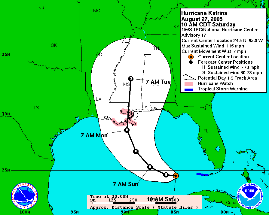
On the 28th, the storm reached Category 5 intensity and the following accurate forecast discussion came out of the New Orleans National Weather Service office:
http://en.wikipedia.org/wiki/National_Weather_Service_bulletin_for_New_Orleans_region#Bulletin_text
On the morning of the 29th, it made landfall as a Category 3 storm on the LA/MS border.
http://einstein.atmos.colostate.edu/~mcnoldy/tropics/katrina05/Katrina_29Aug05.gif
Please visit my tropical Atlantic headquarters.
26 August 2010
Danielle and Earl continue to strengthen...
Since yesterday, Danielle has entered a much more favorable environment and is now nearly a Category 3 hurricane with 90kt winds and a 970mb central pressure. It has also formed a large eye. It is heading NW as forecast and is still expected to recurve by around 62W, keeping it far from any land, with the exception of Bermuda, which could experience some turbulent weather and seas over the next few days.
Shortly after being classified as a Depression, TD7 was upgraded to TS Earl at 21Z yesterday. Earl has been struggling a bit with dry air, and remains a small and disorganized system. The latest intensity estimate is 40kts and 1004mb. However, it is expected to escape its poor environment shortly and begin a multi-day intensification trend, and many models indicate it will become a major hurricane in 5-6 days. It's currently located about 750 miles west of the Cape Verde islands.
Another large and relatively well-organized easterly wave exited the African coast yesterday. In visible satellite imagery, a low-mid-level circulation is evident near 10N 20W (southeast of the Cape Verde islands). The majority of global forecast models develop this system, so it will likely be the next named storm, Fiona, in a few days.
Please visit my tropical Atlantic headquarters.
25 August 2010
Danielle maintaining intensity, TD7 forms...
Due to an intrusion of dry air that interrupted the intensification of Danielle, the storm has barely strengthened in the last 24 hours. The intensity as of 15Z today is 75kts and 982mb. It appears to be recovering now and should be on another intensification trend. Model guidance suggests the storm could reach Category 3 status in 2-3 days before it heads too far north and over colder water.
The latest forecast shows Danielle recurving by 62W, not affecting any land.
The easterly wave that exited the African coast on Monday has been upgraded to TD7 today based on satellite presentation. It's quite well organized and could easily become TS Earl later today. Models are in very good agreement that this system will develop fairly rapidly, becoming the third hurricane of the season within 2-3 days as it heads WNW. On that track, is should be just NE of the Leeward Islands by early next week.
Please visit my tropical Atlantic headquarters.
24 August 2010
Andrew's anniversary, Danielle becomes 2nd hurricane, eastern Atlantic still active...
Today is the 18-year anniversary of Hurricane Andrew's catastrophic landfall near Miami. The eye crossed the coastline at Homestead with a pressure of 922mb. Wind measurements are uncertain, as nearly all anemometers were destroyed, but the strongest gust observations that exist are around 175mph.
http://en.wikipedia.org/wiki/Hurricane_Andrew
http://www.nhc.noaa.gov/gifs/1992andy.JPG
And, here are some very nice radar loops saved by my friend and hurricane chaser Michael Laca in Miami: http://www.youtube.com/watch?v=ZgoqyumbXLE
At 21Z yesterday, Danielle was upgraded to a hurricane, the second of the season. The storm has continued to intensify, now a Category 2 storm with 85kt winds and a 973mb central pressure. It is forecast to reach major hurricane status later today and tomorrow. The track forecast has not changed... still heading WNW then beginning to recurve by 60W.
The easterly wave just off the coast of Africa has also gotten better organized, though isn't quite a Depression yet (as of 14Z). Its estimated intensity is 25kts and 1008mb. It is expected to develop quickly, and most likely become the 3rd hurricane of the season in a few days as it heads WNW. The next name on the list is Earl.
Please visit my tropical Atlantic headquarters.
http://en.wikipedia.org/wiki/Hurricane_Andrew
http://www.nhc.noaa.gov/gifs/1992andy.JPG
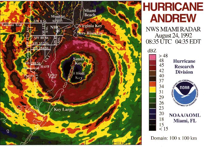
And, here are some very nice radar loops saved by my friend and hurricane chaser Michael Laca in Miami: http://www.youtube.com/watch?v=ZgoqyumbXLE
At 21Z yesterday, Danielle was upgraded to a hurricane, the second of the season. The storm has continued to intensify, now a Category 2 storm with 85kt winds and a 973mb central pressure. It is forecast to reach major hurricane status later today and tomorrow. The track forecast has not changed... still heading WNW then beginning to recurve by 60W.
The easterly wave just off the coast of Africa has also gotten better organized, though isn't quite a Depression yet (as of 14Z). Its estimated intensity is 25kts and 1008mb. It is expected to develop quickly, and most likely become the 3rd hurricane of the season in a few days as it heads WNW. The next name on the list is Earl.
Please visit my tropical Atlantic headquarters.
23 August 2010
TS Danielle nearly a hurricane...
Since my last update on Saturday morning, TD6 was upgraded to TS Danielle on Saturday evening. The storm has continued to organize, and is forming an eye (already evident in microwave imagery, and beginning to appear in visible and infrared imagery). It is nearing hurricane intensity, currently at 55kts and 994mb (and located about 1000 miles west of the Cape Verde islands). It will likely be a hurricane later today.
The global models not only did an exceptional job at forecasting Danielle's development nearly one week in advance, they also did a fine job at predicting a recurvature by 60W, which is still on target to come to fruition. Although still one week away, recurvature is forecast by all of the global and regional models. That certainly won't hinder Danielle reaching hurricane status, and perhaps major hurricane status.
Elsewhere, a new potent easterly wave has just exited the African coast today, but surprisingly, the majority of models do not develop that disturbance. If it should "go", it would likely follow the same track as Danielle since the large-scale steering hasn't changed much.
Please visit my tropical Atlantic headquarters.
21 August 2010
TD6 forms from east Atlantic disturbance...
At 21Z today, the easterly wave that I have been discussing for the last few days near the Cape Verde islands was upgraded to TD6, and the latest estimated intensity is 25kts and 1008mb. It's southwest of the Cape Verdes now, at about 11N 32W and heading WNW at 8kts. Given the favorable environmental conditions in its present location and along the forecast track, the storm is expected to develop rather quickly, reaching Tropical Storm intensity early tomorrow and hurricane intensity by Monday afternoon. Models are in good agreement on the intensification scenario, and on continuing a WNW track for the next few days. At 5-7 days out, it currently appears that the storm (Danielle is the next name) will recurve into the open Atlantic by 60W.
Please visit my tropical Atlantic headquarters.
Please visit my tropical Atlantic headquarters.
20 August 2010
Disturbance off Africa getting better organized...
The easterly wave I mentioned yesterday is now slightly further west than it was, but still generally south of the Cape Verde islands. The visible satellite imagery reveals a rather well-developed surface and mid-level circulation centered near 11N 26W. The latest surface analysis indicates a 1008mb Low associated with the disturbance. It's in (and will remain in) a very favorable environment with low vertical wind shear and 28C SSTs.
In the coming days, it will continue its WNW heading and probably become a Depression, tropical storm, and hurricane this weekend into early next week. The majority of global forecast models indicate possible recurvature by 60W, which would preclude any landfalls, but it's too soon to be certain about that. The next name on the list is Danielle.
Please visit my tropical Atlantic headquarters.
19 August 2010
Large easterly wave exits Africa...
A very large, broad, easterly wave is located just south of the Cape Verde islands, with a disorganized low-mid-level circulation at about 12N 25W (easy to spot from the 07:25Z WindSat and 10:55Z ASCAT microwave scatterometer overpasses). It exited the coast about a day ago, and already has a weak anticyclone positioned over it, greatly reducing the vertical shear and enhancing outflow.
Nearly every global model develops the system substantially, bringing it northeast of the Lesser Antilles (roughly 20N 55W) as a hurricane in about a week.
I've been asked by a few people why the season has been so quiet so far. In reality, it hasn't been; it's been on par with climatology... by this date, an average season has had 3 named storms, 1 hurricane, and 0 major hurricanes, which is exactly what 2010 has seen. Given the continued favorable environment across most of the basin though, once the heart of the season is upon us (very soon), people will be asking why there are so many storms! The bulk of a season's activity typically comes in a relatively short timeframe: http://www.nhc.noaa.gov/gifs/peakofseason.gif.
Please visit my tropical Atlantic headquarters.
10 August 2010
Systems brewing over southern Florida and in central Atlantic...
A very large mid-upper-level Low that has been sitting over southern Florida is getting better organized and apparently developing a surface circulation based on surface and satellite observations. There are widespread thunderstorms associated with the 1010mb Low which is drifting to the WNW. The center of the circulation is just off the southwest FL peninsula, and is visible from the Key West radar: http://radar.weather.gov/radar.php?rid=BYX&product=N0Z&overlay=11101111&loop=yes
The forecast is for this to continue developing... reaching tropical storm intensity as it heads into the LA coast by late Thursday.
The other area of interest is the one I mentioned back in my last update on the 6th... it is now in the middle of the basin, about 800 miles ENE of the Leeward Islands. It is in a strongly sheared environment and although it has persistent deep convection, it's all northeast of the low-level center. Many forecast models do bring it up to TS intensity soon, and recurve it in a day or so, taking it out to the far north central Atlantic (i.e. tropical cyclone graveyard).
At this point, it's hard to say which of the systems could get named first, but if they both do, the next names on the list are Danielle and Earl.
Please visit my tropical Atlantic headquarters.
06 August 2010
Colin still heading over open ocean, two other disturbances getting active...
Colin is still suffering from strong vertical shear, and the tiny low-level circulation has been exposed on the west side of the deep convection. It has begun to recurve (at 67W) and will now make the journey into the open north Atlantic. On its way however, it will have an impact on Bermuda, likely bringing tropical storm conditions to the island on Saturday. The intensity at 15Z today is 40kts and 1007mb... it is forecast to reach 60kts as it makes the extra-tropical transition in a couple days.
The area of disturbed weather I've been mentioning this week in the Caribbean has still not reached land, and is now just north of Honduras and looking surprisingly well-organized. There are impressive convective bands forming all around a mid-level center, vertical shear is low, but it only has perhaps 12 hours until it hits Belize and the Yucatan peninsula. There is a slight chance that it could become a Depression prior to landfall.
There is a new easterly wave that is showing some signs of organization located about 600 miles west of the Cape Verde islands. It's still broad and not very convective, but the forecast is for gradual intensification as it heads northwest.
Please visit my tropical Atlantic headquarters.
05 August 2010
Colin remnants getting better organized...
Convection has returned to the remnants of Colin, and it seems to be very close to being re-classified as a tropical storm (an aircraft will investigate it later today). The vertical shear has relaxed a bit to about 25kts, though the low-level center is still exposed on the far western edge of the convection. It is located 300 miles north of Puerto Rico and moving NW at 15kts.
Many models indicate that the vertical shear is going to relax further and reach a minimum this weekend, perhaps allowing Colin to reach hurricane intensity. It is also still expected to recurve by 70W and head back out over the open north Atlantic.
The system in the central Caribbean has moved westward and is now located 300 miles southwest of Jamaica. There is very little evidence of a low-level circulation, and given its rapid movement, it will almost certainly be over central America before it has a chance to develop.
Please visit my tropical Atlantic headquarters.
04 August 2010
Colin comes and goes, new disturbance in Caribbean...
Since my update on Monday, TD4 was upgraded to TS Colin, but quickly downgraded to a Depression and then to an open wave. As of midday Wednesday, the remnants of Colin are located just northeast of the Leeward Islands and moving very quickly to the WNW. The strong vertical wind shear overwhelmed the young storm, and for next 1-2 days, it will be in the same environment. However, after that, there is a potential for re-development, perhaps even reaching hurricane intensity. There is a lot of agreement among the forecast models that the storm will recurve well before reaching the US, probably by 70W.
The other disturbance is an African easterly wave that looked fairly innocent during the bulk of its journey across the basin, but has recently become more convective. It's located in the central Caribbean, between Haiti and Colombia, and heading W at about 12kts. As far as the forecast goes, it appears that it will continue its current heading, cross over the Yucatan peninsula in about 3 days, then enter the Gulf of Mexico. Should this get named, the next name is Danielle.
Please visit my tropical Atlantic headquarters.
02 August 2010
TD4 forms far from land...
An easterly wave that exited the African continent back on July 29 has gradually gotten better organized, and was upgraded to Tropical Depression 4 at 15Z today based on microwave satellite data. Intensity is estimated to be 30kts and 1006mb, and is moving WNW at 15kts. It presently located about 1300 miles east of the Lesser Antilles.
The forecast is for continued slow strengthening over the next couple of days, then perhaps only maintaining intensity after that as it heads into a less favorable environment (strong vertical shear). By Thursday or so, we should have a clear idea of whether or not the storm will recurve to the north or if the track will flatten out a bit and maintain a WNW heading. If it recurves, it's destined to head out into the open ocean, but it if doesn't recurve by the end of the week, then we have to start thinking about potential landfalls.
The next name on the list is Colin. Colin is a new name this season (all of the names are on a 6-year rotation, until retired due to a significant societal impact), replacing Charley which made landfall near Punta Gorda and Port Charlotte FL on August 13, 2004 as a Category 4 hurricane. While on the topic, other new names this season are Fiona (replaces Frances), Igor (replaces Ivan), and Julia (replaces Jeanne).
Since it's now August, several people have asked how this season stands compared to normal in terms of activity. 2010 is just slightly more active so far compared to an average season. We've seen 2 named storms (3 if TD4 gets named), 1 of which became a hurricane. Climatologically, there are 2 named storms and no hurricanes by this date.
Please visit my tropical Atlantic headquarters.
Subscribe to:
Posts (Atom)