29 September 2019

Amazing Lorenzo becomes season's 2nd Category 5 hurricane

Late Saturday night, Lorenzo beat the odds and was upgraded to a Category 5 hurricane... the second of the season. The last season with two Category 5s was 2017 (Irma and Maria), and then 2007 before that (Dean and Felix).  In my previous blog post on Thursday when Lorenzo was a Category 3 hurricane, I mentioned this possibility and included the historical odds: "It will almost certainly keep going into Category 4 status, and could even reach Category 5 intensity (160+ mph) at some point.  Only about 2% of Atlantic named storms ever achieve Category 5 status".

Enhanced infrared satellite image of Hurricane Lorzeno from around the time it was upgraded to Category 5 intensity. (NOAA)
Not only did it beat the odds, it did so extremely far east; in fact, as Phil Klotzbach at Colorado State University nicely illustrated on a map, it reached Category 5 status about 600 miles further east than the previous easternmost: Hugo (1989).  I added labels to point out the three frontrunners.

Locations where all known Category 5 hurricanes first reached that intensity. (Phil Klotzbach, CSU: https://twitter.com/philklotzbach/status/1178137123687284737)
While this seems quite far north to have such an intense hurricane, the ocean temperatures in that area are normally quite warm this time of the season, and this year they're even warmer.  The water under Lorenzo when it was a Category 5 hurricane is about 28°C (82.4), which is about 1°C (1.8°F) warmer than average... just enough to give it that extra jolt.

Sea surface temperatures (°C), with Lorenzo's Category 5 position marked by a black X. (NASA)
As of 5am EDT on Sunday, it has weakened just slightly to an upper-end Category 4 hurricane with 155 mph sustained winds. The large hurricane (tropical storm force winds extend an average of 205 miles from the center), is forecast to continue tracking to the north then turn northeast, which will bring it near the Azores early Wednesday.  Beyond that, it is expected to begin the transition to an extratropical cyclone, but it will remain quite strong as it heads toward the British Isles on Friday. Both areas could easily experience hurricane conditions including destructive winds and significant storm surge.


Looking back at the history of NHC intensity forecasts for Lorenzo and comparing them to the observed intensity, we can see that the first peak was fairly well-anticipated, but the second and even stronger peak was certainly not.

Elsewhere across the basin, things will remain quiet for the foreseeable future.

26 September 2019

Karen battling dry air as Lorenzo becomes season's 3rd major hurricane

In the far eastern Atlantic, Lorenzo has rapidly intensified to become the season's 3rd major hurricane (Category 3+), with peak sustained winds of 125 mph as of 6am EDT -- just yesterday morning it was at 80 mph.  It will almost certainly keep going into Category 4 status, and could even reach Category 5 intensity (160+ mph) at some point.  Only about 2% of Atlantic named storms ever achieve Category 5 status, so don't hold your breath.

By the way, curious about other percentages? Of all 1637 known named storms (subtropical storms, tropical storms, and hurricanes) in the Atlantic from 1851 to 2019 so far:
  - 58% become Category 1 hurricanes
  - 20% become Category 3 hurricanes
  - 2% become Category 5 hurricanes
The forecast continues to confidently include a turn to the north beginning tonight which will keep this large and very intense hurricane far from land.  The exception to that could be the Azores... Hurricane Lorenzo has a chance to pass near or even over the Azores next Wednesday-Thursday.

Karen is now a minimal tropical storm.  Dry air has taken its toll on the tiny storm, and even after a slight resurgence in thunderstorm activity overnight, its days appear to be numbered.


The forecast from NHC still shows a northward motion through Friday morning, followed by a turn and/or loop toward the west, but continuing to weaken the whole time.  It could dissipate by the end of the weekend.  There is no model guidance that shows any threat to the Bahamas or the U.S. now.

Elsewhere, the basin is quiet, and no new development is expected in the foreseeable future.


25 September 2019

Karen moving away from Puerto Rico, Lorenzo upgraded to 5th hurricane


Karen made landfall on the eastern side of Puerto Rico on Tuesday afternoon as a tropical storm and is now centered about 240 miles north of the island.  As of 11am EDT, the peak sustained winds are 45 mph and it is moving toward the north at 15 mph. The northward motion is expected to continue roughly through Friday, at which point things get messy.


The NHC forecast is in line with most of the model guidance, and shows a stall sometime around Friday, followed by a sharp left turn (there could easily be a little loop in the process) toward the west. That stall-and-turn or loop-and-turn depends on a subtropical ridge building and strengthening to its north, but it also depends on how strong the storm itself is since storms of different intensities are generally steered by different layers of the atmosphere.


Models all agree on a stall and/or loop of some sort, and the large majority show some degree of westward track after that.  But what's not shown on the map above are the intensities.  In some cases, there's barely a trackable system, and there's really no support among dynamical models for anything of hurricane intensity. Clearly, given the potential for impacts in the Bahamas and the southeast US, we'll be watching model trends very closely, but as of now, it's not a cause for concern.

Lorenzo became the season's 5th hurricane on Wednesday morning, and is fully expected to become the season's 3rd major hurricane in a few days.  It is far from land in the deep tropics west of Cabo Verde, and models all agree on a north turn to begin later this week which will keep it out in the middle of the ocean. As of Wednesday morning, the peak winds are 85 mph and the official forecast brings it up to 125 mph (Category 3) by Friday evening.


Tropical Storm Jerry has been transitioned to a post-tropical cyclone, but is still headed toward Bermuda.  It is nearly devoid of rain and thunderstorms, but does have tropical storm force winds associated with it.  It will make its closest approach to Bermuda late Wednesday night. If any rain showers or thunderstorms develop in it, there are radar loops at http://bmcnoldy.rsmas.miami.edu/tropics/radar/. Recall that Jerry formed last Tuesday and peaked as a Category 2 hurricane northeast of the Leeward Islands.


24 September 2019

Three tropical storms keeping the Atlantic busy

Tropical Storm Karen is now closing in on Puerto Rico, Tropical Storm Jerry is a little bit closer to Bermuda, and Tropical Storm Lorenzo is nearly a hurricane out by Cabo Verde.


Karen was briefly downgraded to a depression on Monday night, but has regained tropical storm status and is now centered just 80 miles south of Puerto Rico and moving to the north at 7 mph.  As of this post, heavy rain has not reached the island, but will later today, as will tropical storm force winds. There are long, updating radar loops at http://bmcnoldy.rsmas.miami.edu/tropics/radar/


Since the winds won't be too strong, the biggest concern by far is the rain, and the resulting flash flooding and mudslides. Areas to the right of the storm track could see some minor storm surge, as well as the gustiest winds from the circulation and an elevated tornado threat.  These maps show the outlook for the four hurricane hazards (heavy rain, wind, storm surge, and tornadoes) as of Tuesday morning:


Beyond today's encounter with Puerto Rico, the forecast gets abnormally complicated.  Although the NHC is bound to making a single track forecast and drawing the same "cone" around it that gets drawn around every other storm and forecast all year, the uncertainty is definitely larger than average historical track errors would indicate.

A long list of unknowns is the reason for this, such as its proximity to Jerry, its interaction with Puerto Rico, its sensitivity to wind shear, its sensitivity to dry air, and the strength and position of a building subtropical ridge.  A stronger storm is deeper and is steered by different layers of the atmosphere than a weak storm.  Although the latest NHC forecast shows a northward motion through Friday followed by a sharp left turn and westward motion during the weekend, model guidance is all over the place. This map shows forecast tracks from NHC (thick red line with red dot) as well as three hurricane models, three global models, two global model ensembles, three global model ensemble means, and a couple that are a consensus of some of the others.  It's the dreaded "squashed spider".


So for now, consider Puerto Rico and the Virgin Islands as the places at risk from Karen... everyone else just relax and wait a bit longer to see what's going on.

Jerry is a highly-asymmetric tropical cyclone with barely any thunderstorm activity near the center, and deteriorating quickly -- but it is bringing periodic strong rainbands to Bermuda.  As of 8am EDT today, the peak sustained winds are 60 mph and tropical storm force winds should reach Bermuda by early Wednesday morning.  It's headed north at 8 mph and is expected to make a turn to the northeast later today, bringing the center near or over Bermuda on Wednesday afternoon.  There are also radar loops from Bermuda at http://bmcnoldy.rsmas.miami.edu/tropics/radar/


And much further east, Tropical Storm Lorenzo looks like it's rapidly on its way to becoming the season's 5th hurricane and most likely the 3rd major hurricane in a few days.  It passed well south of Cabo Verde on Monday, and model guidance is in agreement on a turn toward the north this weekend that will keep it very far away from any land.


23 September 2019

Jerry heading for Bermuda, Karen heading for Puerto Rico, soon-to-be Lorenzo near Cabo Verde

The tropical Atlantic continues to bubble with activity, and there could be three named storms by the end of the day.
Tropical Storm Jerry is centered about 350 miles southwest of Bermuda and is forecast to pass just north of (or over) the island on Wednesday as a tropical storm -- about 6.5 days after Category 3 Hurricane Humberto passed north of the island. It is forecast to continue to weaken in the face of wind shear, dry air, and cooler ocean temperatures, but tropical storm conditions should reach Bermuda on Tuesday evening. Beyond the Bermuda encounter, Jerry will dissipate over the cold north-central Atlantic later in the week.
Next on the list is Tropical Storm Karen, which formed on Sunday from a tropical wave near Trinidad and Tobago. It has since entered the far eastern Caribbean and is battling moderate vertical wind shear (it looks like it's losing that battle). The forecast brings it north, and tropical storm warnings are in effect for Puerto Rico and the Virgin Islands.  It's not even a given that it remains intact that long, as some models dissipate it before then.
But, assuming that it holds together, models are in good agreement on a northward track for another 1-2 days after crossing Puerto Rico on Tuesday.  At that point, a strong ridge of high pressure is forecast to build to its north, which would force it to make a sharp left turn to the west.  The ridge is pretty robust in the models, so a continued westward track would bring it toward the Bahamas, Florida, and/or the southeast US coast in about one week.

Track density from the 23Sep 00Z ECMWF 50-member ensemble. The 00Z deterministic run is shown by the cyan dashed line, and the 5-day NHC forecast is the black solid line. (UAlbany)
But that all comes with the uncertainty built into the survival of the tropical cyclone in the next couple of days, the exact strength and position of the ridge, and a list of environmental factors that Karen will need to contend with beyond two days.  At this long lead time, it's just worth being aware of this "left turn" possibility, and knowing that the global models and their ensembles have supported this scenario for a couple days now.

Finally, Tropical Depression 13 is located south of the Cabo Verde islands and is very close to becoming the 12th named storm of the season: Lorenzo.  Models are in excellent agreement on this becoming a strong hurricane in a few days, and on a turn to the north before reaching 60°W.  It appears at this time that it will never be a threat to land.  The NHC forecast brings this close to major hurricane status on Saturday as it begins the northward turn.


20 September 2019

Jerry's turn to take aim at Bermuda, next storm brewing over Africa

As of 8am EDT on Friday, Jerry has strengthened to a Category 2 hurricane with 100 mph peak sustained winds and will pass north of the Leeward Islands later today.  Since the wind field is quite small, impacts on the islands will be minimal, but tropical storm watches are up.  The hurricane also looks very ragged today, hardly the mental image we conjure up when thinking of a Category 2 hurricane.
While confidence in a turn to the north this weekend is high, there's a slim chance (as indicated by about 15% of the ECMWF ensemble members) it stays south and tracks along or near the Greater Antilles. It's just too soon to completely rule that out.  And regarding the NHC "cone of uncertainty", remember that it's designed to enclose the track of the center of the storm just 2/3 of the time, using historical errors. There's historically a 1/3 chance of it tracking outside the cone.

There is a much greater chance that Jerry will pass near Bermuda next Tuesday, not even six days after Category 3 Hurricane Humberto's visit.  This one-two punch is brutal, and actually happened five years ago when Hurricanes Fay and Gonzalo hit the island 5.5 days apart.  When the atmosphere gets stuck in a rut, watch out.

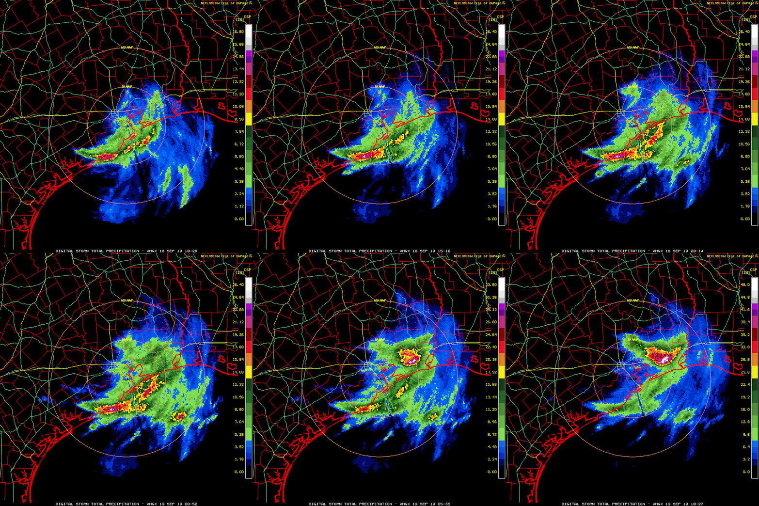
The remnants of Tropical Depression Imelda have finally loosened their wet grip from southeast Texas, and the rainfall totals are staggering.  Local amounts over 42 inches have been reported, and there is significant flooding in the Houston to Beaumont region.

Storm total rainfall estimates as of Thursday evening. https://twitter.com/JZTessler/status/1174821051550883840
This storm *barely* got a name -- it was Tropical Storm Imelda for six hours, just one single advisory on Tuesday afternoon.  That's it.  Clearly, it does not take a hurricane or even a tropical storm to cause major impacts.  But by sneaking into the "named storm" category, the potential exists for the name to be retired.  That decision would not be made until well after the season ends, and a special committee of the World Meteorological Organization convenes (think Jedi High Council).  In the following charts, I am confidently assuming that Dorian will be retired, but leaving Imelda out for now.  What stands out is that "I" storms and September storms are by far the most retired, so Imelda would certainly fit that history! This year was Imelda's first time on a list, having replaced Ingrid when it was retired in 2013.  Other "I" storms that got retired on their first use were Ike, Igor, and Irma.


Shifting our attention way east, a strong tropical wave still over Africa has a lot of support for rapid development in the model guidance. NHC is giving it a 70% chance of becoming at least a tropical depression by early next week, possibly even before reaching Cabo Verde's longitude. Specific examples from the most recent ECMWF and GFS runs are shown below (the shading is low-level cyclonic vorticity, a measure of the curvature of the wind).  The next name on the list is Karen.


19 September 2019

Humberto zips past Bermuda, Imelda drenching Texas, Jerry upgraded to hurricane

The tropical Atlantic continues to be buzzing with activity, which isn't surprising considering it's mid-September. We now have two hurricanes and a tropical depression.  Three other tropical waves have a shot at becoming tropical cyclones in the coming days as well.

Humberto made its closest approach to Bermuda on Wednesday night, and brought a peak wind gust of 116 mph to the island, knocking out power and momentarily knocking out the radar.  The final radar image before a 4-hour-long outage is shown below --  Bermuda was right in the southern eyewall of Category 3 Hurricane Humberto. It has since been downgraded to a Category 2 hurricane and is racing off toward the open northern Atlantic at 24 mph. It will become a large and strong extratropical cyclone by tomorrow.

Tropical Depression Imelda is still sitting over southeast Texas, and dumping FEET of rain in the same places that Harvey flooded in 2017.
Enhanced water vapor satellite image showing a large shield of cold cloud tops sitting over southeast Texas... very dry air is just to the west. (NASA)
Incredible rainrates of 4-6 inches per hour have set up and remained nearly stationary, resulting in rain being measured in feet rather than inches, and peak radar estimates are now over five feet. The loop below is a storm-total rainfall accumulation, where the scale updates to accommodate the maximum values.  By the end of the loop, the scale tops out at about 65 inches.


This once again serves as a reminder that it does not take a strong hurricane to cause tremendous destruction and impacts.  We saw this with Allison (2001), Harvey (2017), and Florence (2018) to name a few. Water is by far the #1 killer when it comes to hurricanes and tropical storms. Tropical cyclones and their remnants are still very wet, and when they become stationary, they're unbelievably wet. The hurricane rating scale (Saffir-Simpson Scale) is ONLY based on the storm's peak sustained wind speed... it says nothing about size of the wind field, rainfall, storm surge, or tornadoes. There's more to the story than the category!

Moving on to the newly-upgraded Jerry... it is now the season's 4th hurricane and is still headed toward the northern Leeward Islands.  Jerry should pass north of the Leewards on Friday, but could bring tropical storm force winds beginning Friday morning.  As of 11am EDT on Thursday, it has peak sustained winds of 75 mph and it's moving toward the west-northwest at 16 mph.

Model guidance is in quite good agreement on it recurving to the north prior to reaching the Bahamas later this weekend, but it is not a closed case. The skillful European model ensemble still has 10-15% of its members indicating that Jerry could remain to the south and track along/near the Greater Antilles. Assuming the most likely scenario, the only encounter with land it will have beyond the Leeward Islands is possibly Bermuda early next week -- about six days after Humberto's visit.
Of the three areas of possible formation shown on the map at the top of the post, the only one strongly supported by models is the easternmost.  A potent tropical wave inland over Africa is expected to come off the continent on Saturday and quickly get its act together.  The next name on the list is Karen.


18 September 2019

Major Hurricane Humberto passing by Bermuda, Imelda flooding Texas, Jerry forms in deep tropics

The Atlantic family portrait on Wednesday afternoon. (CIRA/RAMMB)
Humberto is now a Category 3 hurricane with 120mph peak sustained winds.  As of 2pm EDT, it's centered about 100 miles west-northwest of Bermuda, tracking quickly toward the east-northeast at 20mph, and the tropical storm force winds extend an average of 175 miles from the center.  This is the second major hurricane of the season, after Dorian.  Bermuda will experience hurricane conditions on Wednesday evening/night, including 1-3 feet of storm surge and 2-4 inches of rain.  The latest version of the radar loop shown below is available at http://bmcnoldy.rsmas.miami.edu/tropics/radar/


Imelda was only a named tropical storm for a few hours, and was downgraded to a tropical depression on Tuesday evening, but the flooding threat remains very significant.  Rainfall totals over the past two days are shown below, and the forecast for the next two days is right below that.  This will be a major event (areas with over two feet) when it's all over, but the amorphous storm is crawling north at just 5mph, so it's far from over yet.


Tropical Depression 10 was upgraded to Tropical Storm Jerry early Wednesday morning, making it the 10th named storm of the season.  It is forecast to become the season's 4th hurricane on Thursday as it tracks toward the Leeward Islands.  As of Wednesday afternoon, it's centered 750 miles due east of Martinique and moving toward the west-northwest at 15mph.


The track guidance is still largely in agreement on it passing north of the Leewards on Friday as a hurricane, but tropical storm conditions could arrive in the islands by midday Friday. If the track stays on the south side of the guidance envelope, the northern Leewards could experience hurricane conditions on Friday.  Uncertainty sneaks in via a big patch of dry air to its west right now -- huge differences in forecast evolution crop up depending on it if the storm keeps itself isolated from that or if it wraps it into the circulation.
The forecast is still hazy beyond Friday or so, and that has big implications for the Greater Antilles, the Bahamas, and the southeast US next week.  As of now, about 15% of the ECMWF ensemble members do not recurve the hurricane out to sea before reaching land. And it just so happens that some of that 15% keep the storm rather strong. So, it is definitely something to keep a close eye on with each new model cycle.  The stronger Jerry stays these next few days, the more it will feel the presence of the subtropical ridge and the further south it will stay.


Elsewhere, two other waves have small chances of developing into depressions within the next five days, but considering the amount of current activity, they are not worth going into detail just yet.


17 September 2019

Humberto, Imelda, and soon-to-be-Jerry scattered across the Atlantic

The Atlantic basin now has two named storms, and likely three by day's end.  We have Humberto heading for Bermuda, Imelda inland over Texas, and Tropical Depression 10 east of the Lesser Antilles. 

Humberto is now a Category 2 hurricane and is continuing its trek toward Bermuda. It's centered just 450 miles west of the island and moving toward the east-northeast at 12mph.  They are under a hurricane warning, and dangerous tropical storm force winds should arrive by Wednesday afternoon.  While Humberto is the season's third hurricane, it's only the second Category 2+ hurricane (Dorian was the other).  The latest NHC forecast does bring it up to Category 3 intensity on Wednesday as it passes by Bermuda.  I have a long, updating radar loop from Bermuda at http://bmcnoldy.rsmas.miami.edu/tropics/radar/ which could become interesting on Wednesday.
Tropical Storm Imelda just formed on Tuesday afternoon... inland near Houston TX.  It's certainly unusual to have a tropical storm form over land, especially without so much as a tropical storm watch leading up to it (this was never a "Potential Tropical Cyclone", despite that term being implemented solely for this purpose in 2017).  The first advisory on it was as Tropical Depression 11, on Tuesday early afternoon right on the coastline. It has peak sustained winds of 40mph and it's moving toward the north at 7mph.  It is forecast to weaken, but stranger things have happened (like a few hours ago).

Even prior to this rapid genesis, the big concern was flooding, and that remains the case. Rainfall totals in the area could easily exceed a foot as the storm drifts northward over the next couple days.


Imelda is a new name this year, introduced after Ingrid was retired in 2013.  Curiously, "I" storms are the most-frequently retired, so we'll see what Imelda does in the coming days -- hopefully not enough to earn retirement.

Finally, Tropical Depression 10 is about 1100 miles east of the Lesser Antilles and is forecast to become the season's tenth named storm very soon: Jerry.  Model guidance is in good agreement on it reaching somewhere around the northern Leeward Islands on Friday and the NHC forecast is for it to reach hurricane status around that time.  Beyond that, a slight northward bend will bring it toward the eastern Bahamas later this weekend.  The map below shows the arrival time and probability of tropical storm winds based on the latest 5-day track and intensity forecast.


Beyond that, there is still way too much spread just in the European model's ensemble forecasts to say much.  The realistic scenarios range from a hurricane as far south as Puerto Rico to an early recurve out to sea by about 65°W.  Not only is this a small and weak system, the large-scale steering features will be manipulated and altered by Humberto.  For now, just stay tuned and I will be watching for changes or trends in the ensemble guidance.