27 August 2020

Laura makes Louisiana landfall as borderline Category 5 hurricane


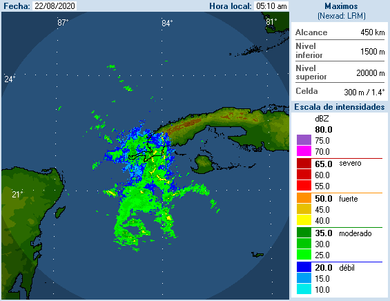
Hurricane Laura rapidly intensified throughout the day on Wednesday and right up to landfall... similar to what Harvey did in 2017 and Michael in 2018.  From 4pm CDT on Tuesday to 4pm on Wednesday, the central pressure fell by 43 mb, and the sustained winds increased by 65 mph, resulting in a jump from a Category 1 to a Category 4 hurricane. By the time it made landfall at 1am CDT on Thursday, the peak sustained winds were 150 mph (Category 5 technically begins at 156 mph), and the central pressure had fallen to 938 mb. The long radar loop of its approach is shown below -- the Lake Charles radar was lost at 1am CDT when the northern eyewall reached it, at which point I switched the source to the more distant Houston radar. There are other radar loops available at http://bmcnoldy.rsmas.miami.edu/tropics/radar/


The eye passed directly over the tiny coastal town of Cameron, which has been wiped off the map several times before by overwhelming storm surge (Audrey 1957, Rita 2005, Ike 2008).  Fewer and fewer people remain each time, and Laura 2020 could be its end. It was reported that at least 100 of the 400 residents did not evacuate the town by Wednesday night.
It's too soon to know what the depth and extent of the storm surge was; that gets manually surveyed which can take at least a couple days for people to get around, locate, and survey high-water marks. But from a few tide gauge stations, it may have been 8-12 feet at its deepest, and that goes a long distance inland with low, flat land.

Laura's wrath does not end at landfall.  The storm surge will take days to recede, but meanwhile, destructive winds follow it inland (it still has 120 mph sustained winds!!), as does very heavy rain and tornadoes. The flash flooding risk over the next three days is shown below. There's still a possibility that when Laura (or what's left of it) exits the U.S. east coast on Saturday, it could re-intensify over the warm ocean, though it will racing away toward Nova Scotia by then.


With this burst of high-intensity action, the seasonal ACE (Accumulated Cyclone Energy) has jumped up a bit to 182% of average for the date, using the past fifty years as the baseline. However, that excess drops to zero (average) on September 6 if no other activity occurs in the meantime.


Across the rest of the Atlantic, it's remarkably quiet for late August.  The only feature of interest is a wave that is just exiting the African coast now. While there is some model support it developing in a few days, it's far from unanimous and there is plenty of time to watch it. But when the time comes, the next name on the list is Nana, and the record-earliest "N" storm formed on September 5 (Nate in 2005).


26 August 2020

Laura rapidly intensifies and is almost a Category 4 hurricane

Laura was a tropical storm early Tuesday morning, but as mentioned in yesterday's blog post, there was a very reasonable chance that it would undergo rapid intensification and become a major hurricane.  It did.  As of 11am EDT on Wednesday, it is an upper-end Category 3 hurricane and is still strengthening.


Landfall is expected near the Texas-Louisiana border at about 1am CDT, which just so happens to coincide with high tide in that area. The latest message from the NWS states: "Unsurvivable storm surge with large, destructive waves will cause catastrophic damage from Sea Rim State Park, TX, to Intracoastal City, LA. Surge could penetrate up to 30 miles inland."  The peak storm surge graphic is shown below, and highlights the area of western LA that could see a 15-20-foot surge:


The storm is well within radar range now, particularly from Lake Charles LA and Houston TX...I have an assortment of long, updating loops at http://bmcnoldy.rsmas.miami.edu/tropics/radar/. Tropical storm force winds have already reached the coast, as have outer rainbands.


As of the 11am EDT advisory, tropical storm force winds extend about 175 miles from the center on the east side, while hurricane force winds extend about 70 miles from the center.  After landfall tonight, it will continue north, then interact with an approaching trough and turn toward the east on Friday.  It could still be a coherent low pressure by the time it exits the US over the mid-Atlantic states on Saturday night and re-strengthen over the ocean on Sunday (though likely as an extratropical cyclone).
Unlike Harvey, which made landfall in Texas as a Category 4 hurricane three years ago today, Laura is not going to stall and dump five feet of rain.  But, as with any tropical cyclone, heavy rain and inland flooding is a big concern. Laura is no different.


Luckily, the remainder of the Atlantic basin is suspiciously quiet for late August. We'll take the break and enjoy it while we can.

25 August 2020

Hurricane Laura enters Gulf of Mexico, Marco makes landfall

Marco was briefly a hurricane as it passed by the western tip of Cuba on Sunday, but began to experience decapitating wind shear after that. By the time it reached the northern Gulf coast on Monday afternoon, it was barely recognizable as a tropical cyclone. But officially, it did make landfall as a tropical storm with 40 mph peak sustained winds right at the mouth of the Mississippi River.  It was much less impactful than feared, which is great because Laura is coming up right behind it, and it means business.

Laura just became the fourth hurricane of the season on Tuesday morning as soon as it left the western tip of Cuba. All signs point to significant intensification in the coming two days before landfall.  When it does make landfall, it will be the seventh named storm to make landfall on the continental U.S. this year (joining Bertha, Cristobal, Fay, Hanna, Isaias, and Marco) so far!


NHC's 11am EDT forecast on Tuesday does bring Laura up to major hurricane status (Category 3) at landfall late Wednesday night. The hurricane and tropical storm warnings as of this advisory are shown below.  The storm surge forecast includes a peak of 9-13 feet in western Louisiana, and lower (but still dangerous) values to the east and west of that.

The global model ensembles are in close agreement on the track -- heading into northern Texas or western Louisiana late Wednesday night into early Thursday morning, and almost certainly as a strong hurricane. In the case of a strong hurricane, the biggest hazard that relies on the exact track is the storm surge -- that will have it maximum just right of center near the eyewall (maximum onshore winds). The timing with the tide cycle also plays a big role. In the area of concern, the tidal range is two feet, so if the peak surge arrives with high tide, the inundation will be two feet more than if it arrives at low tide. In western Louisiana, high tide is expected at 1am on Wednesday night... not good.


Toward the beginning of Laura's life, NHC forecasts were consistently bringing it north too quickly. But over the past couple of days, the forecasts have been essentially unwavering. The map below shows the history of all of NHC's five-day forecasts made since Tropical Depression 13 formed last Thursday.
In terms of environmental influences on Laura's intensity, Marco was too small, too weak, and too quick to have much of an effect on water temperatures in the Gulf; furthermore, Laura is following a different track, so at worst, it would just briefly cross over Marco's wake. The Gulf of Mexico is extremely warm... explosively warm for tropical cyclones. It should experience low to moderate wind shear -- not enough to do serious damage to it. There are indications from rapid intensification guidance that Laura could really get strong in a hurry. One scenario shows an increase of 40 knots in the next day (which would bring it to 105 kt by Wednesday morning). This does not seem unreasonable given the conditions.


In terms of timing, tropical storm conditions are expected to arrive along the northern Gulf coast on Wednesday evening.  In the longer range, there is some model support for Laura maintaining itself as a coherent low pressure system across the southeast US and re-emerging off the mid-Atlantic states on Saturday night.  It may no longer be a tropical cyclone, but could still have tropical storm-force winds as it zips away from the country.


23 August 2020

An extraordinary and dangerous event is unfolding with Laura and Marco


Both Laura and Marco are still tropical storms as of early Sunday morning (Eastern Time). Laura passed south of Puerto Rico yesterday and is now crossing over Hispaniola en route to Cuba by tonight. Marco passed through the Yucatan Channel yesterday and is now heading north toward Lousiana.  Unfortunately, Laura is headed for the same place.

In a truly extraordinary coincidence, Marco is forecast to make landfall in Lousiana as a hurricane on Monday afternoon, then, Laura is forecast to make landfall in Louisana as a hurricane on Wednesday night.  As I pointed out in yesterday's post, this results in two rounds of heavy rain, and two rounds of storm surge, both of which could be mingled together rather than two separate events with a break. The map below shows the forecast tracks and the combined probability of tropical storm force winds (from 5-100% contours).


Marco's tropical storm winds should arrive by Monday morning. Laura is a couple days behind... its tropical storm winds will first affect Dominican Republic, Haiti, and Cuba (with the southern tip of Florida and extreme southern Bahamas in the outskirts), then are expected to reach the northern Gulf coast on Wednesday morning.

The double landfalls will undoubtedly create flooding problems, not only from three days of storm surge coming and going, but from excessive rainfall. The 7-day rainfall forecast is shown below. The flooding will definitely not be limited to the coastal areas. I have radar loops (and more coming) at http://bmcnoldy.rsmas.miami.edu/tropics/radar/


There has been plenty of talk about the "Fujiwhara effect" with these two storms... that is the process where two low pressure systems get close enough to influence each other's tracks.  That influence could be as remote as a mutual nudge or slingshot off in different directions, or orbiting around a common imaginary center between them, or even completely merging.  More technically, this process is called "binary vortex interaction".  In the case of Laura and Marco, the closest they ever get prior to landfall is about 700 miles (they're about 1100 miles apart now), which is just marginal for any interation between the two vortices -- not close enough to do anything exciting like orbit around each other or merge.

We should also not be too quick to write off Laura after its landfall on Wednesday night. The European global model keeps it somewhat coherent as it tracks over the southeast US, and re-emerges over the ocean near the Outer Banks of North Carolina next Sunday and then reintensifies it to at least a tropical storm over the ocean. The American global model follows a similar evolution, but as of now, fails to re-organize it into a tropical cyclone.


Elsewhere across the basin, things are pretty quiet. But when the time comes, the next name on the list is Nana, and the current record earliest "N" name is September 5 (Nate in 2005).

22 August 2020

Laura and Marco strengthening as they head for the Gulf of Mexico

In true 2020 fashion, Laura and Marco, the 12th and 13th named storms of the season, are both strengthening, and are both forecast to be in the Gulf of Mexico on Monday into Tuesday. Laura became the earliest 12th named storm on record yesterday, and Marco became the earliest 13th named storm on record today... beating the previous record by an astounding eleven days.  2020 has now set the record for earliest C, E, F, G, H, I, J, K, L, and M storms!!


Tropical Storm Laura is passing south of Puerto Rico on Saturday and will reach Hispaniola on Saturday night. Then it is forecast to reach eastern Cuba on Sunday evening, western Cuba by midday Monday, and then into the Gulf of Mexico.  The anticipated land interaction with the Greater Antilles will limit its intensification this weekend. But today, while the inner core is south of Puerto Rico over the warm ocean, it is free to strengthen a bit.. and it is.  

As of the 11am EDT advisory, Laura has peak sustained winds of 40mph and is moving toward the west at 18 mph. Heavy rain and tropical storm force winds are affecting the island... I have long, updating radar loops available at http://bmcnoldy.rsmas.miami.edu/tropics/radar/. The one from Puerto Rico shows the increased organization throughout the day.


The model guidance has continued to nudge southward under the influence of a strong subtropical high pressure ridge to the north.  This keeps the storm moving more west than west-northwest, and will almost certainly force it over the Greater Antilles.  There is very little model guidance to suggest otherwise. The intensity forecast is tricky of course, because of the land interaction. But NHC is expecting it to reach hurricane status once it enters the Gulf on Monday night. Beyond that, it looks like it's in line to make landfall on the northwest Gulf coast about a day after Marco does.  This is certainly unusual, and two consecutive landfalls will bring two separate rounds of heavy rain and two mingled and lingering storm surges.  In other words: a mess.


Tropical Storm Marco is passing through the Yucatan Channel today and is developing an eye on radar (not yet evident on satellite images).  It will very likely be Hurricane Marco by tonight as it enters the Gulf of Mexico.


It is forecast to track toward the northwest and reach the Gulf coast around Lousiana or Texas on Tuesday. There will be some interference between Laura and Marco, but the most noticeable impact will be an abnormally large swath of heavy rain and multiple coincidences of storm surge at high tide cycles. Marco is currently forecast to weaken to a tropical storm by the time it reaches the coast due to a substantial increase in vertical wind shear.


It's a bit early for the complex storm surge forecasts to begin, but the rainfall forecast over the coming week looks like this so far, with the forecast tracks of Laura and Marco overlaid:


21 August 2020

Laura and TD14 both aiming for Gulf of Mexico at the same time


Tropical Depression 13 was upgraded to Tropical Storm Laura on Friday morning. This is the season's 12th named storm; the previous record earliest date for the "L" storm was August 29th (Luis in 1995).  Over the past fifty years, the average date of the 12th named storm formation is November 26th: the end of the season.


The tropical storm has peak sustained winds of 45 mph and it's moving toward the west at 18 mph. It will pass over/near the northern Windward Islands later today, Puerto Rico on Saturday morning, and Hispaniola on Saturday night. The tropical storm watches and warnings as of Friday morning are shown below, along with the "cone of uncertainty". Aside from land potentially keeping it weak, it does still have dry air and wind shear to contend with in the near future. The intensity forecast in the Gulf of Mexico comes with a LOT of uncertainty. The global models barely maintain it as a depression in a few days.


During the past day, the model guidance has generally shifted southward, and weaker. In stark contrast to what I wrote in yesterday's post, there is now no model guidance indicating a major hurricane landfall in southeast Florida. Additionally, the majority of the tracks remain just south of Florida. This also increases the probability of land interaction with the Greater Antilles which could actually be its demise. If it survives the next couple of days, it will enter the Gulf of Mexico and be freer to intensify.

Southeast Florida should still be cautiously monitoring for potential impacts on Monday. While a tropical storm or hurricane looks unlikely right now, it cannot be ruled out just yet, and you wouldn't want to be caught completely unprepared if the unlikely scenario is realized.

Tropical Depression 14 is close to becoming Tropical Storm Marco, which will be the record earliest 13th named storm... the current record is September 2. It is located just north of Honduras and is forecast to track toward the northwest for the next several days. This trajectory brings it into the Gulf of Mexico on Sunday morning... Laura is expected to enter the Gulf of Mexico on Monday morning, so it might get crowded.


It is entirely possible that Laura could make landfall along the northern Gulf coast on Tuesday morning, then Marco could make landfall slightly further west on Tuesday morning. They could both be hurricanes at landfall, both be tropical storms, both be tropical depressions, or some mix.  Regardless, it's quite rare, and as they get closer, the low pressures could interact with each other, orbiting around a common center, in a dance known as the Fujiwhara effect.  This wouldn't have an effect on their impacts, but just introduce subtle nudges in each of their tracks.

What we can say this far out is the entire Gulf coast should be closely watching both systems, and preparing for some threat of heavy rain and storm surge over a wide area.

20 August 2020

Tropical Depressions 13 and 14 form and both threaten land


As we head into the end of August, the activity in the tropics is picking up right on schedule.  Invest 97L, which was the disturbance in the central Caribbean, is now Tropical Depression 14, and Invest 98L, which was the disturbance east of the Lesser Antilles, is now Tropical Depression 13. The next two names on the list are Laura and Marco.

I will begin with TD13. This young tropical cyclone left the African coast on Saturday, and has been slow to get going. It is still a ragged-looking tropical depression centered about 750 miles east of the Leeward Islands. It is moving toward the west-northwest at 21 mph and is forecast to gradually strengthen.  At this pace, it will reach the Windward Islands on Friday afternoon, most likely as a tropical storm. Tropical storm watches are in effect for those islands.


Model guidance is really tight on the track for a few days, bringing it just north of Hispaniola on Saturday night.  By Monday morning, the spread increases to include passing over Cuba up to the northern Bahamas, with somewhere in between looking the most likely. That places south Florida squarely in the highest risk area for a landfall or close encounter later on Monday (the 28th anniversary of Hurricane Andrew's landfall).

The intensity is a much more challenging forecast. The environmental factors ahead of it are generally conducive to intensification, aside from a few periods of moderate wind shear. Then exactly how close it passes to Puerto Rico, Hispaniola, and Cuba will have a major influence on how quickly it can strengthen. It if remains far enough away from them, it will tap into very warm water temperatures and be able to strengthen quite a lot.

Since midday yesterday, the regional hurricane models such as HWRF and HMON have consistently been showing at least a Category 3-4 hurricane coming into southeast Florida on Monday.  The latest run of the GFS global model now shows the same thing. The notable outlier is the ECMWF global model and its ensemble. Its deterministic run never even develops it into anything beyond a weak depression or open wave, and the vast majority of ensemble members can't track a coherent low either... just 1 of the 51 members bring it to hurricane intensity in the Gulf of Mexico.

This extreme bifurcation of intensity guidance makes it really challenging for NHC to choose a single intensity forecast!  That said, the most recent suite of dynamical model guidance is shown below (AVNO is the GFS deterministic run, COTC, HMON, and HWRF are three regional hurricane models). Four of the five dynamical models shown on here have a Category 4 hurricane making landfall in southeast Florida on Monday afternoon. This must be taken seriously.


Beyond Monday, most of the guidance tracks this system south of or across the Florida peninsula and into the Gulf of Mexico.  This has implications from the Florida Keys up to Tampa and beyond.  This is the most recent GFS ensemble forecast, showing that the Gulf coast should also be paying very close attention to this -- AS WELL AS the southeast coast of the US if it should happen to recurve northward over the Bahamas like Isaias did.


Speaking of the Gulf of Mexico... it might get crowded early next week. TD14 is located in the western Caribbean and has triggered tropical storm watches for northern Honduras. It too is forecast to become a tropical storm shortly, and head north into the Gulf of Mexico.  So, we could actually have Laura AND Marco sharing the Gulf of Mexico on Monday, and both making US landfalls on Monday.

Unlike TD13, there is not much model support for TD14 becoming a major hurricane, but it could actually briefly become a hurricane this weekend as it approaches the Yucatan peninsula.  It is expected to weaken later on though as it encounters higher wind shear.

And finally, the National Hurricane Center is giving the wave that's just about to exit the African coast a 40% probability of becoming the next tropical cyclone within the next five days.  


19 August 2020

Closely watching three waves in deep tropics

Although there are no active tropical cyclones at the moment, that is about change.  The notable African easterly waves are making the trek across the deep tropical Atlantic. One is now in the central Caribbean (Invest 97L), one is about 1000 miles east of the Lesser Antilles (Invest 98L), and the third is just about to emerge from the African continent (could be Invest 99L).  The first two are very close to developing, while the third will need some time and luck.

"x" marks the current location of each area of interest, and the shading indicates the area of possible formation within the next five days. The probabilities are 80%, 90%, and 20% going west to east.

While it is not at all uncommon to have a string of active waves in late August, it is uncommon that we have Laura, Marco, and Nana as the next three names. The record earliest "L" (12th) storm formation is August 29th (Luis in 1995), and the record earliest "M" (13th) storm formation is September 2nd.  Recall that 2020 has already claimed the record earliest C, E, F, G, H, I, J, and K storms!!  In true 2020 fashion, this is extraordinary.

Now, on to each disturbance...

Invest 97L is centered south of Hispaniola and appears to be experiencing less wind shear than it has been. Neither the European nor American global models -- or the vast majority of their ensemble members -- develop this.  However, the HWRF regional hurricane model certainly does, and the HMON regional hurricane model does as well. 


Of the models that develop it, they indicate a sharp turn to the north on Friday, then intensifying it in the Yucatan/Cuba area before heading into the Gulf of Mexico. Once in the Gulf, the recent HMON run maintains just tropical storm strength (crosses over land), while HWRF heads due north as a Category 1-2 hurricane (stays over water). It has a long way to go, but those summarize the spread of realistic scenarios as of now. For anyone along the Gulf coast, this is worth paying attention to for potential impacts on Monday-Wednesday next week.


Shifting our attention east, Invest 98L is very close to becoming a tropical cyclone, and environmental conditions should be a green light. Some models show it moving into/near drier air in a few days, and that explains the intensity spread... along with interaction with an upper-level trough and potential interaction with Puerto Rico and Hispaniola. In other words, it's an obstacle course, but if the storm can navigate the course, it could be trouble.


The forecast track spread is remarkably low right now. Tracks are clustered tightly over the northern Windward Islands early Saturday, near Hispaniola on Sunday, then Cuba/Florida/Bahamas on Monday into Tuesday. The Americal global model's ensemble (GEFS) is also tightly clustered. Many of these runs show it at hurricane intensity by Monday. It is worth noting that the European global model deterministic and ensemble runs do not develop this disturbance at all. That must be weighed when looking at the remainder of the models. South Florida should be on high alert with this... if it should happen to develop and intensify, it is five days away (Monday evening-ish). As an aside, South Floridians always keep August 24th in their collective memory -- that was Category 5 Hurricane Andrew's landfall date in 1992.


And finally, the wave that is still over western Africa has some fairly big environmental hurdles ahead of it (such as a huge Saharan Air Layer plume to its north and west), so given the amount of activity further west, it's worth an occasional glance, but not much else.


14 August 2020

Kyle forms and shatters yet another record


We are still watching Tropical Storm Josephine approaching the northern Windward Islands in the deep tropics, and meanwhile, Tropical Storm Kyle has also just formed off the coast of New Jersey. Neither will have much of an impact to land, and neither will be around too much longer.

Josephine is still hanging on to tropical storm status, which has been confirmed by aircraft reconnaissance flights into the storm... it has peak sustained winds of 40 mph (minimal tropical storm) and is still forecast to begin turning north and weakening this weekend. While it could affect Bermuda by mid-week, it is not expected to be much more than a healthy breeze at that point.


Kyle actually formed from a low pressure system that tracked across the mid-Atlantic states and got a big boost from the warm Gulf Stream when it emerged over the ocean.  It is moving away from land at 17 mph, and is forecast to strengthen a bit before transitioning to an extratropical cyclone late this weekend.  It is strongly sheared from the west, giving it a very lopsided appearance on satellite images. 


As I mentioned in yesterday's post, the previous record earliest "K" storm was Katrina, which formed on August 24th, 2005. Kyle has shattered that impressive record by ten days. Remember, this is not ten days ahead of average, this is ten days ahead of the previous record!  For reference, the *average* date of the eleventh named storm formation is OCTOBER 24th!

We can again put 2020 in perspective using Accumulated Cyclone Energy, or ACE.  Through August 14, this season is in 21st place (which also happens to be 201% of average over the past fifty years).


The next name on this year's list is Laura.  The current record earliest 12th named storm formed on August 29, 1995 (Luis).  A season that topples any records from 1995 and 2005 is worth paying very close attention to...

13 August 2020

Another record broken as Josephine forms in central Atlantic

Tropical Depression 11 formed on the afternoon of the 11th, and struggled to intensify.  But on Thursday morning, it finally did and was upgraded to Tropical Storm Josephine.  Josephine is the tenth named storm of the season, crushing the previous earliest "J" storm formation record on August 22 (Jose in 2005).  2020 has now produced the record earliest C, E, F, G, H, I, and J storms!  The record earliest K storm is Katrina, which formed on August 24, 2005... there is a really good chance that 2020 will beat that one too.


Josephine does not have a long future ahead of it.  Conditions were marginal for its development, and they will become more hostile this weekend. The official forecast keeps this as a tropical storm through Sunday morning, but some reliable models are not even that generous.  For the track forecast, there is excellent agreement among models that it will pass well north of the Windward Islands on Saturday, and begin turning north toward Bermuda shortly thereafter.


In terms of ACE (Accumulated Cyclone Energy), the season is at 200% of average for this date, using the past fifty years as the baseline.  We are entering the time of year when just keeping up with climatology requires a decent amount of activity... and there are few doubts that this season will remain far ahead of climatology.


But, while 2020 is toppling 2005's records for earliest named storms, it is very, very far from touching the same level of activity. This chart shows the amount of ACE accrued by August 13 going back to 1851... 2005 is in a league of its own, and 2020 is down in 20th place!