30 June 2021

Tropical Depression 5 close to forming east of Lesser Antilles

Invest 97L, the wave that exited the African coast on Sunday, has been transitioned to Potential Tropical Cyclone 5 (still not a tropical depression).  Last year's season moved along at a record-breaking pace, but hang on... the fifth depression formed on July 4 in 2020 and was named on July 6.  There is little doubt now that 2021 will eclipse those records. 

As a refresher, NHC introduced the term "potential tropical cyclone" in 2017 (see season intro), and it refers to an Invest that is likely to produce tropical storm conditions on land within the next 48 hours... it gives them the ability to issue watches and warnings for a tropical cyclone that has not yet formed but is expected to.


This low pressure system is centered about 1200 miles east of the Lesser Antilles and is moving west-northwest at 21 mph, which will bring it to those islands on Friday morning.  Tropical storm watches have been issued for the islands highlighted in yellow below.  The next name on the list is Elsa.  Elsa is a brand new name to the lists, and it replaces Erika which was retired after the 2015 season.


Models have generally been bullish with this for the past few days, though not unanimous.  Some of them bring it to hurricane intensity in the next 2-3 days, then crossing Hispaniola and/or Cuba which always introduces a lack of confidence in the intensity forecast.


Any impacts to the U.S. mainland are still uncertain, but the earliest it would reach the closest area (south Florida) would be late Monday into Tuesday.  There are many other options open to it, so at this point, unless you're in the Lesser Antilles, just wait but pay close attention.

Very few storms have formed this far east so early in the year. I found six tropical cyclones that formed east of 50W prior to July 3 since 1851 -- three of those became tropical storms and only one became a hurricane (in 1933).  The most recent was Bret in 2017.  This one doesn't count as a formation yet, but this map gives you an idea of how exceptional it is in history if it forms in the next few days.


For completeness, Invest 95L is passing through the Lesser Antilles now, but is rapidly losing what organization it had and is not expected to make a comeback.

29 June 2021

Monitoring two waves in the deep tropics

With Tropical Storm Danny out of the picture (if you blinked you missed it), our attention is now solidly on two African easterly waves in the deep tropics.  Invest 95L, the one I wrote about last Thursday, is centered about 800 miles east of the Lesser Antilles, and Invest 97L just left the African coast on Sunday and is about 1800 miles east of the Lesser Antilles. 


In the satellite image above, I superimposed the centers of the two waves from NHC (x) as well as the potential formation area within the next five days (shaded, orange is 40% and corresponds to 95L and yellow is 20% and corresponds to 97L).  Note that this is NOT the "cone of uncertainty" for track because they are not yet tropical cyclones.

On their current trajectories, and regardless of development, 95L will reach the Lesser Antilles by late Wednesday, and 97L will by late Saturday.  At the very least, affected islands there can expect gusty and stormy conditions, and as of now, there is not much indication that either of these waves will be able to intensify too much by then.


The two waves should follow approximately the same track into the Caribbean, but the exact placement will matter.  The central Caribbean Sea is climatologically dominated by a powerful low-level jet, or wind streak, in June and July, so most waves or tropical cyclones that venture there never recover.  If one or both stays further north, environmental conditions would be more favorable for development.

There are too many unknowns this far out to speculate about if and when these waves could reach the US mainland, but for interests in the southeast US, just pay attention (it's that time of year when you want to want to be aware of activity in the tropics every day).

As I mentioned yesterday, the next name on the list is Elsa.  The earliest date of fifth named storm formation is July 6 (Edouard in 2020), and second place goes to July 11 (Emily in 2005).  We would typically be watching two easterly waves and talking about a potential fifth named storm in late August, not late June!

I know it's early, but it is still interesting to keep tabs on where the season stands in terms of ACE, or Accumulated Cyclone Energy.  As a refresher, ACE is the sum of the squares of each named storm's intensity from each advisory... so it is a metric that combines intensity and duration; it is not dependent on the number of storms at all.  For the average, I use the past fifty years (1971-2020).  The 2021 season is about 171% of average for the date.


28 June 2021

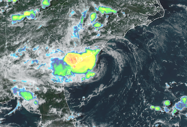
Tropical Storm Danny forms near South Carolina coast


A small low pressure system off the coast of the southeast U.S. was upgraded to Tropical Depression 4 on Monday morning, and then to Tropical Storm Danny on Monday afternoon.  It is headed toward land and will make landfall on Monday evening as a weak tropical storm.  Minimal rainfall and storm surge are expected, but there could be isolated spots with flash flooding in South Carolina and Georgia.


Having the fourth named storm form prior to July is exceptionally rare; it has happened just three times in the past: 2020 (Dolly), 2016 (Danielle), 2012 (Debby). 


Much further east, we are still watching Invest 95L which is in the deep tropics between Cabo Verde and the Lesser Antilles (it will reach the Lesser Antilles on Thursday).  The National Hurricane Center is giving it a 40% probability of becoming a tropical cyclone within the next five days, and the latest 7-day guidance from the European model's ensemble is shown below (track density):


It has some environmental obstacles in its way, but models have been generally consistent on developing this.  Should it become a tropical storm at some point, the next name on the list is Elsa.  Elsa is a brand new name to the lists, and it replaces Erika which was retired after the 2015 season.

24 June 2021

Attention shifts over to Africa... in June??

The large majority of strong Atlantic hurricanes have their origins as "easterly waves" over tropical Africa, and that season is typically August and September.  The waves tend to come off of the continent near the Cabo Verde islands, and we actually refer to that time of year as "Cabo Verde season".  It's quite rare to be paying attention to that area in June, but there's a wave of interest that has a shot at becoming the next tropical cyclone.  NHC is giving it a 40% probability within the next five days.


The European model's 50-member ensemble has been indicating a decent chance of this wave developing into at least a tropical depression in the coming days.  About 10% of the members develop it into a tropical storm, and a subset of those actually reach the Lesser Antilles.  We don't ever take a model run at face value, but the consistency of this has been notable, which gives forecasters some confidence that genesis is possible despite it being climatologically extraordinary.

Track density plot from the ECMWF ensemble out to ten days.  The area in the south-central Caribbean can be ignored... that's a quasi-permanent false alarm.

The map below shows the tracks of all tropical cyclones prior to July since 1851.  There are *2* as far east as this wave is now, so it would be truly remarkable if it developed in the next few days.  If you're curious, the two are a tropical depression that formed just north of Cabo Verde on June 30, 2000, and the other is a tropical depression that formed south of Cabo Verde on June 23, 1974.  You have to go wayyy over to 45.1°W in the central Atlantic to find the easternmost tropical storm formation, and that was in 1933!

Tracks of all known pre-July tropical cyclones in the Atlantic, 1851-2020.

Should this reach tropical storm status at some point, the next name on the list is Danny.  (The name Danny was introduced to the list in 1985 after David was retired in 1979)

19 June 2021

Claudette forms on the Louisiana coast

After watching the "Central American gyre" do its thing for a couple weeks, a named storm finally emerged from it: Tropical Storm Claudette.  And it was first named inland over southeast Louisiana early Saturday morning, just south of New Orleans.  It's quite rare to have the third named storm form so early in the season, but it has happened in 2020, 2016, 2012, 1959, and 1887.  Yes, it seems to be happening with greater frequency lately.  (Claudette is still a name from the original set of lists, first used in 1979)


Although still messy-looking on satellite and radar, it finally acquired the necessary closed surface circulation to become a tropical cyclone just as the center was coming ashore.  All of the rain was displaced east of the center.


It's always important to remember "there's more to the story than the category"... as even a marginal tropical storm has produced flash flooding, spawned numerous tornadoes in Alabama and Georgia,  and is already responsible for several deaths.

Now that it's inland, the hazards don't magically end.  Heavy rain is expected along its track out to North Carolina in the coming days, and a tropical storm watch is already in effect for eastern North Carolina because the remnants of Claudette are expected to re-strengthen as it nears the coast.  The map below shows the rainfall forecast through the next five days.


Elsewhere, the Atlantic basin is quiet, so nothing in the near future.  But when the time comes, the next name on the list is Danny.  And a bit of history: Danny has been in the six-year cycle since 1985... it replaced David which was retired in 1979.

17 June 2021

Gulf of Mexico storm taking shape, warnings issued


The area of disturbed weather that I mentioned in my previous blog post on Monday morning has spent the past few days getting organized and is now well on its way to becoming the season's third tropical cyclone.

As of Thursday afternoon, it is classified as "Potential Tropical Cyclone 3", which means that it's still an Invest (not quite a tropical cyclone) but with watches and warnings attached because of its anticipated strengthening and proximity to land.  Indeed, tropical storm warnings are in effect from central Louisiana over to the Florida panhandle.

If this develops just a bit more, it will be upgraded to Tropical Depression 3, and then Tropical Storm Claudette.  But time is against it, as it will reach the northern Gulf coast by early Saturday.


It is a very broad and diffuse low pressure system, with a sprawling cloud shield displaced almost entirely to the east of the center. Although it has no chance of becoming anything menacing, it will bring heavy rain to the northern Gulf coast.  You will be able to monitor the rainfall using a long updating radar loop at http://bmcnoldy.rsmas.miami.edu/tropics/radar/. And as I mentioned on Monday, the areas that this storm will impact have still not recovered from the brutal 2020 hurricane season.  

The rainfall outlook over the coming week is shown here, and local totals could certainly be higher.  Peak values on this map are about one foot, and the widespread area covered by 3"+ (red-orange-yellow) is quite impressive.


It's worth mentioning that this system, an offshoot of a Central American gyre, has been in the model-world picture for nearly two weeks now!!  These can be notoriously slow to develop, and many never do.

[By the way, the system that was off the North Carolina coast on Monday was later upgraded to Tropical Storm Bill, but was short-lived as it raced off toward the northeast.]

14 June 2021

Watching two features of interest, one with U.S. impacts

Monday morning's enhanced infrared satellite image with the two features of interest marked with Xs. The orange blobs define the region in which NHC suspects each of them could form within the next five days (both have a 50% probability).

It is only June 14, but there's a small chance of reaching the second and third tropical cyclones of the Atlantic hurricane season already.  The first feature of interest is a very slowly-evolving broad area of circulation in the Bay of Campeche (southern Gulf of Mexico) which has been festering and organizing for over a week already.  Tagged as "Invest 92L"*, it is going to ooze northward toward Texas and Louisiana over the next 5-6 days.

[* Invest is a term given to an area of interest, such systems get recycled numbers from 90-99 throughout the season, and L refers to the atLantic.  So, 92 is the third such invest of the season, and there will be several other 92Ls in the coming months.  They only receive a unique number once they have undergone genesis and reached tropical depression status.]

Even if it never becomes a tropical cyclone, it will still bring very heavy rain to the storm-weary and saturated northern Gulf coast on Friday-Sunday.  If it does develop, then add some wind to that rain -- but water is the big story.

Rainfall outlook over the next seven days.

As is typically the case with these large and diffuse systems, its future is especially uncertain.  Models have a difficult time pin-pointing when it will consolidate (if ever), and that timing affects the track, which affects the intensity. The map below shows tracks from the European model's ensemble out to Saturday evening.  Other models show similar messiness. Don't worry about an exact track anyway, the rain will cover a big area, as the map above suggests.


While 92L may still take a few days to get organized, Invest 93L is very close to being a tropical cyclone.  It is a low pressure system embedded in the tail end of a long cold front and is centered just east of North Carolina.  It is moving away from the coast and will just bring some chances of stormy weather to the Outer Banks today.  It has just a short window to do anything though; as it zips off to the northeast it will quickly encounter cold ocean temperatures by mid-week.

3.5-hour radar loop of 93L just east of the Outer Banks.

Should they both end up getting named, the system by North Carolina would be first (possibly today??), and the next two names on this year's list are Bill and Claudette.