- Visit the Tropical Atlantic Headquarters.
- Subscribe to get these updates emailed to you.
- Follow me on Twitter
31 August 2012
Kirk and Leslie signs of active season
My update for today can be found on Washington Post's "Capital Weather Gang" blog. Thanks for reading, and have a great Labor Day weekend!
30 August 2012
Isaac, Kirk, and TD12 keeping the basin active
This is the time of year when the tropical Atlantic really gets cooking, and this year is no exception. Isaac was the season's forth hurricane, Kirk is now the fifth, and we'll soon have another to add to the list: TD12 just formed and is primed to strengthen quickly.

ISAAC
The figure below shows the past 5 days of estimated rainfall over the southeast US, along with Isaac's track in black. The very localized maximum over the Palm Beach FL region can clearly be seen (we had some significant and stagnant raindbands here in southeastern Florida), as well as the much more obvious and widespread huge totals over southern LA, MS, and AL. There are of course many problems with inland flooding now... in addition to the hundreds of miles of coastline affected by the large storm surge -- from central LA all the way over to the FL panhandle. This goes to show once again to never focus on the exact centerline of the track. These are large storms with severe impacts felt very far from the center.

I have a full 50-hour radar loop of Isaac's path over the northern Gulf coast, as well as the rest of the prior radar loops for Isaac.
Isaac is now a 35kt tropical storm, and still centered over Louisiana (with strong winds and rainbands extending out for hundreds of miles). It's been over land since Tuesday evening, and is still a tropical storm... the hot swampy southern half of LA doesn't provide the usual death blow to a tropical system that other locations do.

Warning: I'm going to go on a little rant now... I've heard reports of people saying "I didn't think it was going to be this bad", and "I didn't leave because it was only a Category 1". THE CATEGORY OF A STORM HAS NOTHING TO DO WITH RAINFALL OR STORM SURGE. Not a thing. The only thing that distinguishes a tropical storm from a major hurricane is wind speed in the center of the storm. Forecasts of storm surge and rainfall were quite accurate, evacuation orders were made, we had Katrina as a recent teacher, yet people still perceived the only risk as being the peak winds. Hopefully after a few more storms like this (since history is forgotten after about a year), perhaps some people in vulnerable areas will begin to realize that they are at risk from other elements besides the peak winds right at the center of the storm. And another key point: THERE IS NO SUCH THING AS A WEAK HURRICANE. By definition, even a Category 1 hurricane's winds are destructive. I realize there are people who do not have the means to evacuate, and for them, I hope better government-sponsored (local or state) programs can be designed to help them. But for the people who stay just because they feel they're not at risk despite the warnings from hurricane experts and emergency managers... how many destructive storms will it take to convince them? End rant.
KIRK
As of yesterday's update, Kirk had just formed. Today it's a 65kt hurricane! It is in the process of recurving, and should bend back toward the northeast before reaching 53W.

TD12
Finally, the disturbance that I mentioned yesterday that was near 36W is now near 45W, and was just recently upgraded to Tropical Depression 12. The intensity is estimated to be 30kts and 1007mb; and is forecast to become a hurricane this weekend as it heads WNW... likely recurving north of the Lesser Antilles. It's presently about 1100 miles east of the Lesser Antilles and moving west at 17kts. While it appears to be a storm that will never affect land, it's too far out to say for certain, so is worth keeping a close eye on. This is very close to becoming Tropical Storm Leslie, and interestingly, the average hurricane season never even reaches the "L" storm.


ISAAC
The figure below shows the past 5 days of estimated rainfall over the southeast US, along with Isaac's track in black. The very localized maximum over the Palm Beach FL region can clearly be seen (we had some significant and stagnant raindbands here in southeastern Florida), as well as the much more obvious and widespread huge totals over southern LA, MS, and AL. There are of course many problems with inland flooding now... in addition to the hundreds of miles of coastline affected by the large storm surge -- from central LA all the way over to the FL panhandle. This goes to show once again to never focus on the exact centerline of the track. These are large storms with severe impacts felt very far from the center.
I have a full 50-hour radar loop of Isaac's path over the northern Gulf coast, as well as the rest of the prior radar loops for Isaac.
Isaac is now a 35kt tropical storm, and still centered over Louisiana (with strong winds and rainbands extending out for hundreds of miles). It's been over land since Tuesday evening, and is still a tropical storm... the hot swampy southern half of LA doesn't provide the usual death blow to a tropical system that other locations do.
Warning: I'm going to go on a little rant now... I've heard reports of people saying "I didn't think it was going to be this bad", and "I didn't leave because it was only a Category 1". THE CATEGORY OF A STORM HAS NOTHING TO DO WITH RAINFALL OR STORM SURGE. Not a thing. The only thing that distinguishes a tropical storm from a major hurricane is wind speed in the center of the storm. Forecasts of storm surge and rainfall were quite accurate, evacuation orders were made, we had Katrina as a recent teacher, yet people still perceived the only risk as being the peak winds. Hopefully after a few more storms like this (since history is forgotten after about a year), perhaps some people in vulnerable areas will begin to realize that they are at risk from other elements besides the peak winds right at the center of the storm. And another key point: THERE IS NO SUCH THING AS A WEAK HURRICANE. By definition, even a Category 1 hurricane's winds are destructive. I realize there are people who do not have the means to evacuate, and for them, I hope better government-sponsored (local or state) programs can be designed to help them. But for the people who stay just because they feel they're not at risk despite the warnings from hurricane experts and emergency managers... how many destructive storms will it take to convince them? End rant.
KIRK
As of yesterday's update, Kirk had just formed. Today it's a 65kt hurricane! It is in the process of recurving, and should bend back toward the northeast before reaching 53W.
TD12
Finally, the disturbance that I mentioned yesterday that was near 36W is now near 45W, and was just recently upgraded to Tropical Depression 12. The intensity is estimated to be 30kts and 1007mb; and is forecast to become a hurricane this weekend as it heads WNW... likely recurving north of the Lesser Antilles. It's presently about 1100 miles east of the Lesser Antilles and moving west at 17kts. While it appears to be a storm that will never affect land, it's too far out to say for certain, so is worth keeping a close eye on. This is very close to becoming Tropical Storm Leslie, and interestingly, the average hurricane season never even reaches the "L" storm.
- Visit the Tropical Atlantic Headquarters.
- Subscribe to get these updates emailed to you.
- Follow me on Twitter
29 August 2012
As Isaac hits Louisiana, Kirk forms
Isaac was upgraded to a hurricane just before landfall, and actually continued to strengthen as it got closer and closer to the coast. Not only that, it also stalled, and is sitting in basically the same place for 12 hours and counting. The full radar loop of Isaac's approach from the New Orleans radar is very illustrative for both the intensification and the stalling. It first clipped the Mississippi delta on Tuesday evening, then the center moved offshore just a little, and came ashore again about 70 miles west several hours later. However, hurricanes are large, and damaging effects are always felt very far from the exact center.

As expected, the storm has caused massive power outages (half a million and increasing) and substantial storm surge. The surge was almost perfectly forecast by the NHC, and peaked at about 11' in Shell Beach LA, 8' in Bay St. Louis MS, 4' in Mobile Bay AL, 3' in Pensacola FL, and reports of significant surge in Destin FL. The storm surge will again be a major contributor to the damage, even for a low-end Category 1 hurricane. Storm surge is intentionally no longer a part of the Saffir-Simpson intensity scale.
The rainfall is another big factor, as was very well forecast by HPC. Here is the 24-hour rainfall estimate ending at 6am CDT this morning (so obviously the final values will be higher)...

For completeness, I will show the latest satellite image with forecast track overlaid. Isaac is currently a 70kt Category 1 hurricane, and is drifting to the northwest at 5kts. The motion is forecast to turn more to the north as it dissipates over land, producing large amounts of rain along its path.

KIRK
In what seems to be a Circle of Life in the tropics, just as Isaac makes landfall and is destined to dissipate into nothing, Tropical Storm Kirk is born far to the east. The disturbance that I mentioned in yesterday's first update was upgraded to Tropical Depression 11 at 5pm EDT, and then upgraded again to Tropical Storm Kirk just six hours later. Kirk is the season's 11th named storm, which is 57 days ahead of climatology, 5 days behind the 2005 mega-season, and 1 day behind the 1995 mega-season. It's located about 1400 miles southwest of the Azores, truly in the middle of the basin and no threat to land. It is forecast to strengthen and recurve to the northeast.

AL98
And, we have another potent easterly wave to be watching. This one left the African coast on August 26 and is now about 1600 miles east of the Lesser Antilles. There is good agreement among global models that this system will develop and be located just northeast of the Lesser Antilles in 5 days, but probably revurve by about 60-65W. The next name on the list is Leslie.

As expected, the storm has caused massive power outages (half a million and increasing) and substantial storm surge. The surge was almost perfectly forecast by the NHC, and peaked at about 11' in Shell Beach LA, 8' in Bay St. Louis MS, 4' in Mobile Bay AL, 3' in Pensacola FL, and reports of significant surge in Destin FL. The storm surge will again be a major contributor to the damage, even for a low-end Category 1 hurricane. Storm surge is intentionally no longer a part of the Saffir-Simpson intensity scale.
The rainfall is another big factor, as was very well forecast by HPC. Here is the 24-hour rainfall estimate ending at 6am CDT this morning (so obviously the final values will be higher)...
For completeness, I will show the latest satellite image with forecast track overlaid. Isaac is currently a 70kt Category 1 hurricane, and is drifting to the northwest at 5kts. The motion is forecast to turn more to the north as it dissipates over land, producing large amounts of rain along its path.
KIRK
In what seems to be a Circle of Life in the tropics, just as Isaac makes landfall and is destined to dissipate into nothing, Tropical Storm Kirk is born far to the east. The disturbance that I mentioned in yesterday's first update was upgraded to Tropical Depression 11 at 5pm EDT, and then upgraded again to Tropical Storm Kirk just six hours later. Kirk is the season's 11th named storm, which is 57 days ahead of climatology, 5 days behind the 2005 mega-season, and 1 day behind the 1995 mega-season. It's located about 1400 miles southwest of the Azores, truly in the middle of the basin and no threat to land. It is forecast to strengthen and recurve to the northeast.
AL98
And, we have another potent easterly wave to be watching. This one left the African coast on August 26 and is now about 1600 miles east of the Lesser Antilles. There is good agreement among global models that this system will develop and be located just northeast of the Lesser Antilles in 5 days, but probably revurve by about 60-65W. The next name on the list is Leslie.

- Visit the Tropical Atlantic Headquarters.
- Subscribe to get these updates emailed to you.
- Follow me on Twitter
28 August 2012
Isaac upgraded to hurricane, storm surge underway
At 11:20am EDT, NHC upgraded Isaac to a hurricane. It has been steadily marching across the Atlantic for the past 12 days, and now, just hours before its final landfall, it nudges past the hurricane threshold.

But that is merely a name change at this point... the difference in wind speed is minimal from what it was before. The important part is that it's a very large and dangerous storm. Areas along the coasts of Alabama, Mississippi, and Louisiana are already experiencing 3-5' storm surges, and that will increase throughout the day. In many locations however, the receeding tide will help offset the encroaching surge, but not completely. Here is the latest storm surge forecast using the most current track and intensity data (this is the 10% excedance version):

But that is merely a name change at this point... the difference in wind speed is minimal from what it was before. The important part is that it's a very large and dangerous storm. Areas along the coasts of Alabama, Mississippi, and Louisiana are already experiencing 3-5' storm surges, and that will increase throughout the day. In many locations however, the receeding tide will help offset the encroaching surge, but not completely. Here is the latest storm surge forecast using the most current track and intensity data (this is the 10% excedance version):
- Visit the Tropical Atlantic Headquarters.
- Subscribe to get these updates emailed to you.
- Follow me on Twitter
Isaac nearly a hurricane as it bears down on Louisiana
Today's update can be found on the Washington Post's "Capital Weather Gang" blog. Please stop by there for the latest update on Tropical Storm Isaac.
Elsewhere, there's a sheared disturbance in the middle of the Atlantic (very far from the Cape Verdes, Azores, Lesser Antilles... everything!). It appears to be close to reaching Tropical Depression status, or if it becomes a tropical storm, the next name on the list is Kirk.

Elsewhere, there's a sheared disturbance in the middle of the Atlantic (very far from the Cape Verdes, Azores, Lesser Antilles... everything!). It appears to be close to reaching Tropical Depression status, or if it becomes a tropical storm, the next name on the list is Kirk.
- Visit the Tropical Atlantic Headquarters.
- Subscribe to get these updates emailed to you.
- Follow me on Twitter
27 August 2012
Tropical storm Isaac’s final landfall set for Tuesday evening as hurricane
Today's update can be found on the Washington Post's "Capital Weather Gang" blog. Please stop by there for the latest update on Tropical Storm Isaac.
- Visit the Tropical Atlantic Headquarters.
- Subscribe to get these updates emailed to you.
- Follow me on Twitter
26 August 2012
Isaac to pass over Keys, heads for Gulf coast
Today's update can be found on the Washing Post's "Capital Weather Gang" blog. Please stop by there for the latest update on Tropical Storm Isaac.
Aside from Isaac, the easterly wave in the far eastern Atlantic is not all that impressive yet, but I will continue to monitor it.
Aside from Isaac, the easterly wave in the far eastern Atlantic is not all that impressive yet, but I will continue to monitor it.
- Visit the Tropical Atlantic Headquarters.
- Subscribe to get these updates emailed to you.
- Follow me on Twitter
25 August 2012
First U.S. hurricane warnings issued for Isaac
Isaac did not end up reaching hurricane intensity prior to making landfall on the southwestern peninsula of Haiti, but was intensifying as it came ashore at around 2am EDT this morning. The peninsula is very mountainous, but also very thin, so Isaac's core only remained over land for about 3 hours, and is now back over water (Windward Passage) before it makes another brief landfall on Cuba's southeastern coast shortly. You can follow this from the Gran Piedra radar loop (and others later).
At 8am EDT, the center was located in the Windward Passage, about 95 miles east-southeast of Guantanamo, Cuba. I marked the center with a red L here, and you can see that the storm is still pretty lopsided, and that there's a disturbance to its northwest affecting southern Florida and the western Bahamas... BEFORE Isaac even arrives tomorrow into Monday. As of 8am, the maximum sustained winds are 60mph, it's heading northwest at 14mph, and tropical storm force winds extend an impressive 230 miles from the center.

Since the track will end up involving relatively limited time over land, that gives the storm longer than anticipated to intensify prior to reaching southern Florida. As such, hurricane watches and warnings are now in effect for Andros Island in the Bahamas, as well as all of southern Florida. In this graphic below, hurricane warnings are red, hurricane watches are pink, tropical storm warnings are blue, and tropical storm watches are yellow. If you're new to the lingo, here are the definitions from the NHC:

The probability of tropical storm force winds over the next 5 days is shown here. Specifically, here's a table showing the probability of each wind intensity for some select cities (these will evolve as the storm approaches):

The other big issue will be the rain. The following storm-total rainfall forecast spans 3 days, so some places will get their rain before it even starts in others. Totals along the northern Gulf coast will be much higher, and will be included in future versions of the graphic.

Just for completeness, the disturbance in the far eastern Atlantic is not yet getting organized, and is now a couple hundred miles west of the Cape Verde islands.
At 8am EDT, the center was located in the Windward Passage, about 95 miles east-southeast of Guantanamo, Cuba. I marked the center with a red L here, and you can see that the storm is still pretty lopsided, and that there's a disturbance to its northwest affecting southern Florida and the western Bahamas... BEFORE Isaac even arrives tomorrow into Monday. As of 8am, the maximum sustained winds are 60mph, it's heading northwest at 14mph, and tropical storm force winds extend an impressive 230 miles from the center.
Since the track will end up involving relatively limited time over land, that gives the storm longer than anticipated to intensify prior to reaching southern Florida. As such, hurricane watches and warnings are now in effect for Andros Island in the Bahamas, as well as all of southern Florida. In this graphic below, hurricane warnings are red, hurricane watches are pink, tropical storm warnings are blue, and tropical storm watches are yellow. If you're new to the lingo, here are the definitions from the NHC:
A HURRICANE WARNING MEANS THAT HURRICANE CONDITIONS ARE EXPECTED SOMEWHERE WITHIN THE WARNING AREA. A WARNING IS TYPICALLY ISSUED
36 HOURS BEFORE THE ANTICIPATED FIRST OCCURRENCE OF TROPICAL STORM FORCE WINDS...CONDITIONS THAT MAKE OUTSIDE PREPARATIONS DIFFICULT
OR DANGEROUS. PREPARATIONS TO PROTECT LIFE AND PROPERTY SHOULD BE RUSHED TO COMPLETION.
A HURRICANE WATCH MEANS THAT HURRICANE CONDITIONS ARE POSSIBLE WITHIN THE WATCH AREA...IN THIS CASE WITHIN THE NEXT 24 TO 36 HOURS.
A TROPICAL STORM WARNING MEANS THAT TROPICAL STORM CONDITIONS ARE
EXPECTED SOMEWHERE WITHIN THE WARNING AREA WITHIN 36 HOURS.
A TROPICAL STORM WATCH MEANS THAT TROPICAL STORM CONDITIONS ARE
POSSIBLE WITHIN THE WATCH AREA...GENERALLY WITHIN 48 HOURS.
For the most recent rack forecast, watches, and warnings, visit the NHC website.
The probability of tropical storm force winds over the next 5 days is shown here. Specifically, here's a table showing the probability of each wind intensity for some select cities (these will evolve as the storm approaches):
TS HURR
----------------------------
MIAMI | 67 | 4
KEY WEST | 72 | 16
FORT MYERS | 68 | 9
TAMPA | 57 | 5
APALACHICOLA | 64 | 11The other big issue will be the rain. The following storm-total rainfall forecast spans 3 days, so some places will get their rain before it even starts in others. Totals along the northern Gulf coast will be much higher, and will be included in future versions of the graphic.

Just for completeness, the disturbance in the far eastern Atlantic is not yet getting organized, and is now a couple hundred miles west of the Cape Verde islands.
- Visit the Tropical Atlantic Headquarters.
- Subscribe to get these updates emailed to you.
- Follow me on Twitter
24 August 2012
Isaac strengthens, Joyce weakens, new disturbance brewing
ISAAC
Despite the majority of model guidance and human forecasters, Isaac is still a low-end tropical storm. A recon flight this morning did find winds strong enough to bump the intensity up to 45kts, which is actually the strongest it's ever been (at 65kts, it would become a hurricane). The minimum surface pressure is down to 1000mb, and the center is located just 130 miles south of the southern Dominican Republic coast... moving west at 15mph. A turn to the WNW then NW is expected later today.

Isaac seems to finally be getting its act together, based on aircraft observations and satellite presentation. As you can see in the satellite image above, the exact center of the storm doesn't matter too much... areas hundreds of miles away are feeling the effects of Isaac, both in terms of wind and rain. Tropical storm force winds now extend out to 185 miles from the storm's center. The 5-day forecast cone (yes, it's important not to focus on the exact center of the cone), tropical storm watches (yellow), tropical storm warnings (blue), and hurricane watches (pink) from 8am EDT this morning are shown here, you should look for the latest version at the NHC website.
A huge impact in the coming days will be rain. From the Dominican Republic, Haiti, Jamaica, Cuba, Bahamas, and Florida, then up into the northeast Gulf coast. Much of southern Florida could receive 6-9" in the next few days, with locally higher amounts. Areas in Haiti and Dominican Republic could see 10-20" of rain, and 6-12" in Jamaica and eastern Cuba. Even if Isaac doesn't quite reach hurricane intensity, the rain associated with tropical systems is always a big threat.
JOYCE
Shortly after my update yesterday morning, TD10 was indeed upgraded to TS Joyce as expected... making it the 10th named storm of the season, a full 58 days ahead of climatology! It was also the second earliest date on record to reach the 10th named storm, lagging behind the mega-season of 2005 when Jose became a TS on August 22, and tieing the other mega-season of 1995 with Jerry. This is shaping up to be another astoundingly active season, at least in terms of the number of storms.
However, Joyce's fame was short-lived, and just twelve hours after reaching TS intensity, it weakened to a Depression and is now fizzling out due to formidable shear and dry air. In this messy image below, there are several things being shown. First, the bright green L in the middle is the center of the surface circulation. The background grayscale image is the infrared satellite picture, the yellow lines are the vertical shear magnitude (20kts, 30kts, 40kts, etc), the white lines are the vertical shear direction, and finally, the yellow-orange-red shading denotes the low-mid-level dry air, with redder colors being dustier/drier areas. The point is that Joyce has a LOT working against it! What's left of Joyce is located about 1300 miles west of the northern Cape Verde islands and moving northwest.

AL97
And, it wouldn't be the end of August without having another easterly wave to talk about! A new easterly wave left the African coast yesterday after marching across the continent since August 17 (you can track these waves yourself with the help of a time sequence of infrared images). This wave has a 1007mb embedded Low shown by the red L, and is expected to slowly develop as it heads WNW. It is no immediate threat to anything.

Despite the majority of model guidance and human forecasters, Isaac is still a low-end tropical storm. A recon flight this morning did find winds strong enough to bump the intensity up to 45kts, which is actually the strongest it's ever been (at 65kts, it would become a hurricane). The minimum surface pressure is down to 1000mb, and the center is located just 130 miles south of the southern Dominican Republic coast... moving west at 15mph. A turn to the WNW then NW is expected later today.
Isaac seems to finally be getting its act together, based on aircraft observations and satellite presentation. As you can see in the satellite image above, the exact center of the storm doesn't matter too much... areas hundreds of miles away are feeling the effects of Isaac, both in terms of wind and rain. Tropical storm force winds now extend out to 185 miles from the storm's center. The 5-day forecast cone (yes, it's important not to focus on the exact center of the cone), tropical storm watches (yellow), tropical storm warnings (blue), and hurricane watches (pink) from 8am EDT this morning are shown here, you should look for the latest version at the NHC website.

A huge impact in the coming days will be rain. From the Dominican Republic, Haiti, Jamaica, Cuba, Bahamas, and Florida, then up into the northeast Gulf coast. Much of southern Florida could receive 6-9" in the next few days, with locally higher amounts. Areas in Haiti and Dominican Republic could see 10-20" of rain, and 6-12" in Jamaica and eastern Cuba. Even if Isaac doesn't quite reach hurricane intensity, the rain associated with tropical systems is always a big threat.
JOYCE
Shortly after my update yesterday morning, TD10 was indeed upgraded to TS Joyce as expected... making it the 10th named storm of the season, a full 58 days ahead of climatology! It was also the second earliest date on record to reach the 10th named storm, lagging behind the mega-season of 2005 when Jose became a TS on August 22, and tieing the other mega-season of 1995 with Jerry. This is shaping up to be another astoundingly active season, at least in terms of the number of storms.
However, Joyce's fame was short-lived, and just twelve hours after reaching TS intensity, it weakened to a Depression and is now fizzling out due to formidable shear and dry air. In this messy image below, there are several things being shown. First, the bright green L in the middle is the center of the surface circulation. The background grayscale image is the infrared satellite picture, the yellow lines are the vertical shear magnitude (20kts, 30kts, 40kts, etc), the white lines are the vertical shear direction, and finally, the yellow-orange-red shading denotes the low-mid-level dry air, with redder colors being dustier/drier areas. The point is that Joyce has a LOT working against it! What's left of Joyce is located about 1300 miles west of the northern Cape Verde islands and moving northwest.

AL97
And, it wouldn't be the end of August without having another easterly wave to talk about! A new easterly wave left the African coast yesterday after marching across the continent since August 17 (you can track these waves yourself with the help of a time sequence of infrared images). This wave has a 1007mb embedded Low shown by the red L, and is expected to slowly develop as it heads WNW. It is no immediate threat to anything.

- Visit the Tropical Atlantic Headquarters.
- Subscribe to get these updates emailed to you.
- Follow me on Twitter
23 August 2012
Hurricane Andrew 20th Anniversary
During the early morning hours of August 24, 1992, one of the most powerful hurricanes to ever hit the US made landfall just south of Miami, Florida. Hurricane Andrew was a very late first named storm of the otherwise quiescent 1992 season. The full track is shown here, but most noteworthy is that it was a Category 5 storm over the Bahamas and heading into Florida.

My friend and veteran hurricane chaser Michael Laca is a native Miamian, and recorded some video before, during, and after Andrew's passage through the area. After 20 years, he made a monumental effort to convert his old analog tape recordings to digital format so this historic footage can live on. Please take a few minutes to watch his video clip... it's quite humbling.
http://www.youtube.com/watch?v=lO0TGcRm6LM
There is an infamous final radar image captured by the radar on the roof of the National Hurricane Center when it was located in the Gables One Tower along US Hwy 1 (the + symbol on the map). This was at 4:35am when the wrath of the monster storm was only halfway over. If anything positive can be found about this storm, it's that 1) it was extremely small which limited the areal extent of the strongest winds and 2) the eyewall didn't pass directly over the Miami metro area.

You can read more about the history and aftermath of Andrew at:
http://en.wikipedia.org/wiki/Hurricane_Andrew
http://www.srh.noaa.gov/mfl/?n=andrew
http://www.miamiherald.com/2012/06/12/2845424/hurricane-andrew-20-years-later.html
http://www.npr.org/2012/08/23/159613339/hurricane-andrews-legacy-like-a-bomb-in-florida
- Visit the Tropical Atlantic Headquarters.
- Subscribe to get these updates emailed to you.
- Follow me on Twitter
Isaac passing south of Puerto Rico, TD10 organizing
Isaac passed over the Leeward Islands on Wednesday afternoon as a tropical storm, and remains a relatively weak 40mph tropical storm as of the 8am EDT advisory today. It's located about 225 miles south of Puerto Rico. You can find radar loops of Isaac from Martinique, Puerto Rico, and other sites in the future here.

Two noteworthy things have happened since yesterday's update: the storm turned a bit south of due west for 12 hours yesterday evening, and the forward speed decreased to a more normal 11kts (13mph). The southward bump could be significant because it should take that much longer to start getting pulled northward toward Cuba and Florida, increasing the odds of a more western track... and the slower motion is more conducive for strengthening.
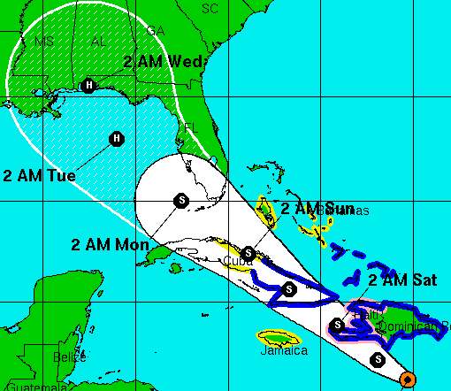
The plot below shows the morning model runs, which haven't shifted very much. It's never a good idea to dwell on a single model or a single run too seriously; but rather, to assess the spread in the various models (indicates uncertainty in the large-scale steering), and the trends of the models over several runs and several days. Over the past few days, there has been relatively little spread, and the trends have been somewhat steady too, with a track over or near Haiti, then eastern-central Cuba, then southern Florida. The exact details for a US impact are impossible to know this far out... just watch Isaac closely if you're in Florida, the central-eastern Gulf coast, or even the Carolinas. As you can see, just a small shift in the track means a difference between the FL panhandle and the SC coast!

Isaac is still forecast to acquire hurricane intensity prior to reaching the Hispaniola area, then weaken to a tropical storm during the encounters with Hispaniola and Cuba. After Cuba, it should re-intensify as it approaches southern Florida. In southern FL, expect conditions to go downhill on Sunday, with the worst weather coming on Monday.
The figure below shows the probability of tropical storm force winds occurring within the next 5 days, based on this morning's advisory package. The bright yellow shading that nudges into south Florida is the 30-40% bin, and each contour is a different 10% bin from there. As the storm's position and path get closer to a given location, the probabilities go up, as you'd expect. You can find the full/latest figure, as well as others, at the NHC website.

Elsewhere, TD10 has changed little in the past day, and is now located about 1100 miles west of the Cape Verde islands, or about 1300 miles east of the Leeward Islands. It is forecast to slowly strengthen, and continue its northwest motion. It's quite likely that this will be upgraded to Tropical Storm Joyce today.


Two noteworthy things have happened since yesterday's update: the storm turned a bit south of due west for 12 hours yesterday evening, and the forward speed decreased to a more normal 11kts (13mph). The southward bump could be significant because it should take that much longer to start getting pulled northward toward Cuba and Florida, increasing the odds of a more western track... and the slower motion is more conducive for strengthening.
The plot below shows the morning model runs, which haven't shifted very much. It's never a good idea to dwell on a single model or a single run too seriously; but rather, to assess the spread in the various models (indicates uncertainty in the large-scale steering), and the trends of the models over several runs and several days. Over the past few days, there has been relatively little spread, and the trends have been somewhat steady too, with a track over or near Haiti, then eastern-central Cuba, then southern Florida. The exact details for a US impact are impossible to know this far out... just watch Isaac closely if you're in Florida, the central-eastern Gulf coast, or even the Carolinas. As you can see, just a small shift in the track means a difference between the FL panhandle and the SC coast!

Isaac is still forecast to acquire hurricane intensity prior to reaching the Hispaniola area, then weaken to a tropical storm during the encounters with Hispaniola and Cuba. After Cuba, it should re-intensify as it approaches southern Florida. In southern FL, expect conditions to go downhill on Sunday, with the worst weather coming on Monday.
The figure below shows the probability of tropical storm force winds occurring within the next 5 days, based on this morning's advisory package. The bright yellow shading that nudges into south Florida is the 30-40% bin, and each contour is a different 10% bin from there. As the storm's position and path get closer to a given location, the probabilities go up, as you'd expect. You can find the full/latest figure, as well as others, at the NHC website.
Elsewhere, TD10 has changed little in the past day, and is now located about 1100 miles west of the Cape Verde islands, or about 1300 miles east of the Leeward Islands. It is forecast to slowly strengthen, and continue its northwest motion. It's quite likely that this will be upgraded to Tropical Storm Joyce today.

- Visit the Tropical Atlantic Headquarters.
- Subscribe to get these updates emailed to you.
- Follow me on Twitter
22 August 2012
Isaac heads for Caribbean, TD10 forms
At 5pm EDT yesterday, TD9 was upgraded to TS Isaac based on an aircraft reconnaissance flight into the storm. Isaac is the 9th named storm of the season, and comes 35 days ahead of climatology. After struggling with some light shear and mid-level dry air yesterday afternoon, centralized deep convection returned by the evening and has persisted, indicating that it is likely going to intensify further today. The visisble satellite shown here (from 9:15am EDT) gives you a perspective of the size and location of the storm.

As of the 8am EDT intermediate advisory, Tropical Storm Isaac had 40kt sustained winds and was located about 200 miles east of Guadeloupe in the Leeward Islands. I have a long radar loop from Martinique available which shows the full approach of the storm to the Lesser Antilles, and will continue to run until it's out of range. Other radars will pick it up then, so stay tuned to that link as I add more.
Given its location and intensity forecast, there are quite a lot of hurricane and tropical storm watches/warnings in effect (blue=TS warning, yellow=TS watch, pink=H watch). As of 8am, there are not any hurricane warnings, but that could change later today.

Of course, track and intensity forecasts aren't perfect, and there is still some spread in the various model solutions, and some inherent uncertainty in the official forecast. In the graphic above, the "cone of uncertainty" depicts NHC's average track error over the past 5 years at the different lead times (actually, it's the 67th percentile of their errors). For example, for a 24h forecast, the full width of the cone is 129 miles, while at 120h (5 days), the cone expands to 543 miles across. In addition to that uncertainty, it's important to remember that the storm is big, and the center line or points along the track only symbolize the exact center of the storm. Locations hundreds of miles away from the storm center can still experience severe conditions. Notice that even using the latest cone, the track could be on the west coast of Florida, or stay offshore to the east... both are still very realistic scenarios.
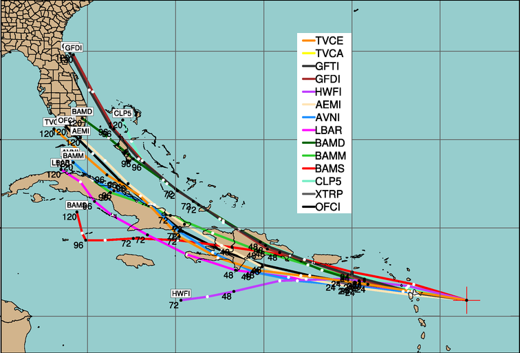
The plot below from my colleague Jonathan Vigh at NCAR/TCGP (we were both formerly at CSU) shows 5-day track forecasts from several models valid at 8am EDT today. Of particular interest is that there was a general nudge to the west with this run compared to previous runs.

Given the large chance for land interactions with Hispaniola and Cuba, Isaac's intensification should be halted for a couple days as it passes over them on Friday and Saturday. But, between its current location and Hispaniola, and then again north of Cuba, conditions are ripe to sustain some substantial intensification. The official forecast keeps it as a Category 1 hurricane through 5 days, but that too can change, so stay tuned. And as I mentioned before, if you're anywhere near the projected path, it's never too early to make your emergency plans and general preparations.
Elsewhere, the easterly wave I've been talking about that exited the African coast on August 18th has been upgraded to Tropical Depression 10. The 1007mb Low is centered about 700 miles west of the Cape Verde islands and tracking WNW. Model guidance suggests that this system will intensify in the coming days, and continue its WNW-NW motion. The next name on the list is Joyce.


As of the 8am EDT intermediate advisory, Tropical Storm Isaac had 40kt sustained winds and was located about 200 miles east of Guadeloupe in the Leeward Islands. I have a long radar loop from Martinique available which shows the full approach of the storm to the Lesser Antilles, and will continue to run until it's out of range. Other radars will pick it up then, so stay tuned to that link as I add more.
Given its location and intensity forecast, there are quite a lot of hurricane and tropical storm watches/warnings in effect (blue=TS warning, yellow=TS watch, pink=H watch). As of 8am, there are not any hurricane warnings, but that could change later today.

Of course, track and intensity forecasts aren't perfect, and there is still some spread in the various model solutions, and some inherent uncertainty in the official forecast. In the graphic above, the "cone of uncertainty" depicts NHC's average track error over the past 5 years at the different lead times (actually, it's the 67th percentile of their errors). For example, for a 24h forecast, the full width of the cone is 129 miles, while at 120h (5 days), the cone expands to 543 miles across. In addition to that uncertainty, it's important to remember that the storm is big, and the center line or points along the track only symbolize the exact center of the storm. Locations hundreds of miles away from the storm center can still experience severe conditions. Notice that even using the latest cone, the track could be on the west coast of Florida, or stay offshore to the east... both are still very realistic scenarios.
The plot below from my colleague Jonathan Vigh at NCAR/TCGP (we were both formerly at CSU) shows 5-day track forecasts from several models valid at 8am EDT today. Of particular interest is that there was a general nudge to the west with this run compared to previous runs.
Given the large chance for land interactions with Hispaniola and Cuba, Isaac's intensification should be halted for a couple days as it passes over them on Friday and Saturday. But, between its current location and Hispaniola, and then again north of Cuba, conditions are ripe to sustain some substantial intensification. The official forecast keeps it as a Category 1 hurricane through 5 days, but that too can change, so stay tuned. And as I mentioned before, if you're anywhere near the projected path, it's never too early to make your emergency plans and general preparations.
Elsewhere, the easterly wave I've been talking about that exited the African coast on August 18th has been upgraded to Tropical Depression 10. The 1007mb Low is centered about 700 miles west of the Cape Verde islands and tracking WNW. Model guidance suggests that this system will intensify in the coming days, and continue its WNW-NW motion. The next name on the list is Joyce.

- Visit the Tropical Atlantic Headquarters.
- Subscribe to get these updates emailed to you.
- Follow me on Twitter
21 August 2012
TD9 heads for Caribbean, two other disturbances being monitored
In my blog for the Washington Post today, I focused on newly-formed TD9, so please stop there for details on that storm. All interests in the eastern Caribbean, Florida, and the Carolinas should be watching this VERY closely. An aircraft reconnaissance flight into the storm is planned for later today... that will be our first real assessment of the intensity. It could be upgraded to TS Isaac depending on what they find!
Elsewhere, there are two other disturbances worth watching.
The first is related to the remnants of Helene, and partially to the trailing edge of a trough and attendant cold front. It's a rather sloppy system with a 1010mb elongated Low centered about 140 miles south of Brownsville TX. It is forecast to drift back to the west into Mexico and remain weak, though it could briefly become a TD or TS in the meantime. The only threat from this is the heavy rain and all that entails.

The other system is far to the east, about 550 miles southwest of the Cape Verde Islands. This easterly wave left the African coast on the 18th, and is gradually getting better organized. It's expected to track to the WNW over the next several days and slowly intensify.

After Isaac, the next couple names on the list are Joyce and Kirk.
- Visit the Tropical Atlantic Headquarters.
- Subscribe to get these updates emailed to you.
- Follow me on Twitter
20 August 2012
Very active tropical Atlantic as we enter core of hurricane season
Today's update will be from a post I did for the Washington Post's "Capital Weather Gang" and is available here.
Please let me know if you have trouble viewing it, and I will help you.
Please let me know if you have trouble viewing it, and I will help you.
- Visit the Tropical Atlantic Headquarters.
- Subscribe to get these updates emailed to you.
- Follow me on Twitter
18 August 2012
Atlantic still active with three storms/disturbances
Gordon is now a hurricane and heading for the Azores, TD7 is now TS Helene, and the disturbance in the far eastern Atlantic continues to get better organized.
GORDON
At 09Z today, Gordon was upgraded to a hurricane... the third of the season... based on an improving satellite presentation (most notably, an eye). The intensity is 65kts with a 988mb central pressure. It is still zipping off to the east at 16kts, and the anticipated closest approach to the Azores remains Sunday night into Monday morning, likely as a tropical storm. We could still be watching Gordon into the middle of next week as it heads toward Portugal... though probably not as a tropical cyclone.

HELENE
At 2130Z yesterday (5:30pm EDT), a special advisory was issued to upgrade former TD7 to TS Helene based on aircraft reconnaissance data. The storm has been nearly stationary (just a slow northward drift) and sitting off the coast of Mexico near Veracruz. Fortunately, it is not very well organized and doesn't have a lot of rain coverage over land. At 12Z today, it was a 35kt storm and just 35 miles southeast of Veracruz and crawling to the northwest at 7kts. In the image below, the center is shown right on the coast, and the thin white line shows its path over the past few days. I also have radar loops available here (the Altamira site has excellent coverage of the storm, but there's limited precipitation associated with the storm to show up on radar). Helene is forecast to continue its slow northward drift and gradually weaken over near-coastal Mexico. The latest position, forecast, and warnings from NHC can be found at http://www.nhc.noaa.gov/storm_graphics/AT07/refresh/AL0712W5_NL+gif/114451W5_NL_sm.gif.

AL94
Finally, on to the disturbance in the far eastern Atlantic. It is now centered near 12N 28W with an estimated 1008mb surface pressure.

Unfortunately, we still have limited regional model guidance being run on this system due to the other activity closer to land, but all signs point to this becoming a strong hurricane as it heads west toward the Lesser Antilles. As far as track goes, global deterministic and ensemble models are good at that, and they suggest a steady westward motion, with some members indicating the possibility for some recurvature to the NW in a few days. An important thing to point out is that models have been trending southward with the track... a couple days ago, the majority were showing recurvature, and now that's more of an outlier solution.


GORDON
At 09Z today, Gordon was upgraded to a hurricane... the third of the season... based on an improving satellite presentation (most notably, an eye). The intensity is 65kts with a 988mb central pressure. It is still zipping off to the east at 16kts, and the anticipated closest approach to the Azores remains Sunday night into Monday morning, likely as a tropical storm. We could still be watching Gordon into the middle of next week as it heads toward Portugal... though probably not as a tropical cyclone.
Visible satellite image of Hurricane Gordon from 1215Z today, courtesy of NOAA/NESDIS.
HELENE
At 2130Z yesterday (5:30pm EDT), a special advisory was issued to upgrade former TD7 to TS Helene based on aircraft reconnaissance data. The storm has been nearly stationary (just a slow northward drift) and sitting off the coast of Mexico near Veracruz. Fortunately, it is not very well organized and doesn't have a lot of rain coverage over land. At 12Z today, it was a 35kt storm and just 35 miles southeast of Veracruz and crawling to the northwest at 7kts. In the image below, the center is shown right on the coast, and the thin white line shows its path over the past few days. I also have radar loops available here (the Altamira site has excellent coverage of the storm, but there's limited precipitation associated with the storm to show up on radar). Helene is forecast to continue its slow northward drift and gradually weaken over near-coastal Mexico. The latest position, forecast, and warnings from NHC can be found at http://www.nhc.noaa.gov/storm_graphics/AT07/refresh/AL0712W5_NL+gif/114451W5_NL_sm.gif.

Satellite image of Helene from 1245Z, courtesy of NASA/GSFC.
AL94
Finally, on to the disturbance in the far eastern Atlantic. It is now centered near 12N 28W with an estimated 1008mb surface pressure.
Visible satellite image of AL94 from 1345Z, courtesy of CIRA/RAMMB.
Unfortunately, we still have limited regional model guidance being run on this system due to the other activity closer to land, but all signs point to this becoming a strong hurricane as it heads west toward the Lesser Antilles. As far as track goes, global deterministic and ensemble models are good at that, and they suggest a steady westward motion, with some members indicating the possibility for some recurvature to the NW in a few days. An important thing to point out is that models have been trending southward with the track... a couple days ago, the majority were showing recurvature, and now that's more of an outlier solution.
The current satellite image and position, with various 5-day forecast model tracks shown in the multi-colored lines. The Lesser Antilles is the island chain on the left side of the image, and denote the eastern boundary of the Caribbean Sea.
This system has a good chance of becoming TD9 in the next 1-2 days, and then the next name on the list is Isaac. To throw in a bit of climatology with it, I centered the storm on its projected location in 24 hours from now (it might be a numbered storm by then), and searched for any storms within 100 miles of that location during the past 160 Augusts to see what storms have historically done. The tracks are shown below... the vast majority do recurve, but a handful are notorious and include Donna 1960, Frederic 1979, and Dean 2007, so this needs to be taken seriously.
- Visit the Tropical Atlantic Headquarters.
- Subscribe to get these updates emailed to you.
- Follow me on Twitter
17 August 2012
Watching 3 systems scattered across the basin
Tropical Storm Gordon is still heading for the Azores, TD7 is making an impressive comeback near the Mexican coast, and the disturbance in the far eastern Atlantic is organizing.

GORDON
TS Gordon reached an intensity of 60kts at 03Z on Friday (Thursday 11pm EDT), but has since weakened a bit to 55kts at 09Z today. It is still forecast to reach hurricane status within the next day or so as it heads for the Azores at 16kts. It's presently about 1000 miles west of the Azores, so should reach the islands Sunday night into Monday morning, likely as a tropical storm.

TD7
If you recall, TD7 degenerated into an open wave back on the 11th just as it was approaching the Lesser Antilles. It remained a coherent wave since then, though couldn't acquire a closed surface circulation, and the convection associated with it was meager. It passed over Nicaragua, Honduras, Belize, Guatemala, and southern Mexico prior to re-emerging over the Gulf of Mexico. There is also some evidence that the remnants of TD7 mingled with another disturbance a couple days ago, so its pedigree is perhaps a little mixed now. But, this morning, the system is located over the western Bay of Campeche (extreme southwestern Gulf of Mexico) and appears to be intensifying.

I have radar loops from two sites in Mexico available to help monitor the circulation as well. Later today, reconnaissance aircraft will be investigating the system to accurately determine its intensity. This disturbance (former TD7 and possibly TD7 again, or even TS Helene depending on what the aircraft finds) is heading WNW at 9kts. It should reach the Mexican coast near Tampico by Saturday morning.
AL94
The disturbance that left the African coast yesterday continues to shows signs of organization. The surface center appears to be near 12N 21W, which is amazing luck since there's a buoy at 12N 23W (just southeast of the Cape Verdes)... we should be able to get a decent idea of the surface pressure soon.

Models continue to favor the development of this system in a big way. A classic W-WNW track for at least the next 5-7 days will bring it a few hundred miles east of the Lesser Antilles. Beyond that, model uncertainty is too high to base predictions on. The limited amount of model guidance so far suggests that this could be a major hurricane within a week.


Tracks of all of these systems are available here.
GORDON
TS Gordon reached an intensity of 60kts at 03Z on Friday (Thursday 11pm EDT), but has since weakened a bit to 55kts at 09Z today. It is still forecast to reach hurricane status within the next day or so as it heads for the Azores at 16kts. It's presently about 1000 miles west of the Azores, so should reach the islands Sunday night into Monday morning, likely as a tropical storm.
Visible satellite image of Gordon from 7:45am EDT... courtesy of NOAA/NESDIS.
TD7
If you recall, TD7 degenerated into an open wave back on the 11th just as it was approaching the Lesser Antilles. It remained a coherent wave since then, though couldn't acquire a closed surface circulation, and the convection associated with it was meager. It passed over Nicaragua, Honduras, Belize, Guatemala, and southern Mexico prior to re-emerging over the Gulf of Mexico. There is also some evidence that the remnants of TD7 mingled with another disturbance a couple days ago, so its pedigree is perhaps a little mixed now. But, this morning, the system is located over the western Bay of Campeche (extreme southwestern Gulf of Mexico) and appears to be intensifying.

Visisble satellite image from 8:40am, courtesy of NASA/GHCC. The green line is the Mexican coastline.
I have radar loops from two sites in Mexico available to help monitor the circulation as well. Later today, reconnaissance aircraft will be investigating the system to accurately determine its intensity. This disturbance (former TD7 and possibly TD7 again, or even TS Helene depending on what the aircraft finds) is heading WNW at 9kts. It should reach the Mexican coast near Tampico by Saturday morning.
AL94
The disturbance that left the African coast yesterday continues to shows signs of organization. The surface center appears to be near 12N 21W, which is amazing luck since there's a buoy at 12N 23W (just southeast of the Cape Verdes)... we should be able to get a decent idea of the surface pressure soon.
Visisble satellite image from 8:15am.
Models continue to favor the development of this system in a big way. A classic W-WNW track for at least the next 5-7 days will bring it a few hundred miles east of the Lesser Antilles. Beyond that, model uncertainty is too high to base predictions on. The limited amount of model guidance so far suggests that this could be a major hurricane within a week.

- Visit the Tropical Atlantic Headquarters.
- Subscribe to get these updates emailed to you.
- Follow me on Twitter
16 August 2012
Gordon becomes 7th named storm of the season
The huge easterly wave that left the African coast back on August 9th (the same one that was attempting to form two distinct Lows on the 10th) has been in a very hostile environment for the past week, but finally escaped the Saharan Air Layer that contained the choking dry low-mid level air. At 21Z yesterday (5pm EDT), it was upgraded to TD8, then just twelve hours later, upgraded again to TS Gordon, the seventh named storm of the Atlantic season. The tracking map shown below gives you an appreciation of just how far it traveled as a disorganized yet trackable feature prior to earning a number (AL08).
 At 09Z today (5am EDT), Gordon was a 35kt storm with a 1011mb central pressure located about 1600 miles WSW of the Azores and heading NNE at 12kts. It is forecast to continue recurving and pass over the Azores on Monday morning as a tropical storm, but could reach hurricane status in the meantime.

Elsewhere, a new easterly wave is leaving the African coast today after traveling across the continent for the past 5 days. The embedded 1012(ish)mb Low is centered near 9N 16W. This will definitely be something to watch closely, as many of the global models develop it and keep it somewhat south and near 15N 50W in a week. Once Gordon is out of the picture (soon), all attention will be diverted to this system, and regional models will soon be run on it as well. Once (and if) named, the next name on the list is Helene.


Tropical Storm Gordon at 7:45am EDT today.
Elsewhere, a new easterly wave is leaving the African coast today after traveling across the continent for the past 5 days. The embedded 1012(ish)mb Low is centered near 9N 16W. This will definitely be something to watch closely, as many of the global models develop it and keep it somewhat south and near 15N 50W in a week. Once Gordon is out of the picture (soon), all attention will be diverted to this system, and regional models will soon be run on it as well. Once (and if) named, the next name on the list is Helene.

Visible satellite image of the eastern Atlantic and western Africa from 7:15am EDT today.
- Visit the Tropical Atlantic Headquarters.
- Subscribe to get these updates emailed to you.
- Follow me on Twitter
12 August 2012
Quiet weekend in the tropics
Dry air and shear have taken their toll on the two systems I mentioned on Friday. TD7 was downgraded to an open wave on Saturday at 15Z, and the complex disturbance near the Cape Verdes (the one that had potentially two distinct centers) has been eroded away by huge amounts of dry air streaming off of Africa. The large-scale visible satellite image below shows the basin as of 2:45pm EDT today. Ex-TD7 is the feature near 15N 67W (south of Puerto Rico), and the eastern Atlantic "Invest" is now up near 21N 39W (not near anything!).

Neither of these systems are down for the count though, and we certainly need to keep a close eye on Ex-TD7 as it traverses the Caribbean. The system in the eastern Atlantic has the potential to intensify over the next few days as it recurves to the NW then N... the environment will be conducive for some strengthening and it could become TD8/Gordon this week. As far as Ex-TD7 goes, it is presently in a very high-shear environment (~25kts), but as this image from 5:15pm EDT today shows, it's at least a very potent and coherent easterly wave.

Elsewhere, another easterly wave has just exited the African coast today, but models aren't too bullish on developing it just yet.
- Visit the Tropical Atlantic Headquarters.
- Subscribe to get these updates emailed to you.
- Follow me on Twitter
10 August 2012
TD7 forms, TD8 on the way?
With Ernesto dissipating over the mountains of southern Mexico (producing a LOT of rain), I will focus on the two systems in the eastern Atlantic.
First, the easterly wave that left Africa on August 5 was upgraded to Tropical Depression 7 at 21Z (5pm EDT) yesterday. The visible satellite image below is from today at 7:45am EDT when the Depression was centered about 800 miles east of the Lesser Antilles. It's traveling west at a speedy 17kts.

It is forecast to remain fairly weak through the next 5 days due to a combination of vertical shear and dry air (sounds a lot like Ernesto!). But, on its expected trajectory, it should cross over the Lesser Antilles late Saturday into Sunday morning, then reach Jamaica (the general vicinity, not necessarily a landfall on the island) by Tuesday afternoon. Track guidance is shifting gradually to the north, which could bring it closer to Hispaniola rather than the open Caribbean -- that would have a huge impact on the intensity.
The plots below show the intensity, track ,and some environmental parameters (shear, SST, RH) from key models.

Now on to the system that I've been mentioning over Africa. It finally exited the coast on Thursday night, and model guidance was triggered immediately for it. The wave actually has a couple of embedded Lows, one up near 16N 20W and the other further south near 9N 20W. This is quite remarkable! The primary 1004mb Low is the one to the north, but the one further south seems to be organizing as well. The image here shows the infrared satellite image as the gray background, then ship observations are plotted on top, and the line contours basically show low-level rotation... you can see the broad-scale circulation, but also a separate one down near 9N. I won't rely much on model guidance for this yet until we know which center will be the key player.

First, the easterly wave that left Africa on August 5 was upgraded to Tropical Depression 7 at 21Z (5pm EDT) yesterday. The visible satellite image below is from today at 7:45am EDT when the Depression was centered about 800 miles east of the Lesser Antilles. It's traveling west at a speedy 17kts.

It is forecast to remain fairly weak through the next 5 days due to a combination of vertical shear and dry air (sounds a lot like Ernesto!). But, on its expected trajectory, it should cross over the Lesser Antilles late Saturday into Sunday morning, then reach Jamaica (the general vicinity, not necessarily a landfall on the island) by Tuesday afternoon. Track guidance is shifting gradually to the north, which could bring it closer to Hispaniola rather than the open Caribbean -- that would have a huge impact on the intensity.

Now on to the system that I've been mentioning over Africa. It finally exited the coast on Thursday night, and model guidance was triggered immediately for it. The wave actually has a couple of embedded Lows, one up near 16N 20W and the other further south near 9N 20W. This is quite remarkable! The primary 1004mb Low is the one to the north, but the one further south seems to be organizing as well. The image here shows the infrared satellite image as the gray background, then ship observations are plotted on top, and the line contours basically show low-level rotation... you can see the broad-scale circulation, but also a separate one down near 9N. I won't rely much on model guidance for this yet until we know which center will be the key player.
- Visit the Tropical Atlantic Headquarters.
- Subscribe to get these updates emailed to you.
- Follow me on Twitter
Subscribe to:
Posts (Atom)