22 September 2020

Beta makes landfall, Teddy heads for Canada, Paulette is back


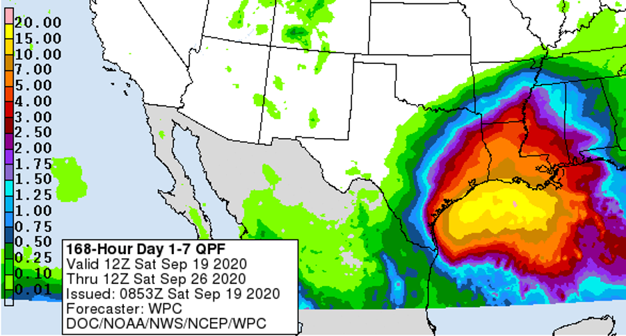
Tropical Storm Beta made landfall in Port O'Connor, Texas on Monday night and as anticipated, the wind and the storm surge were not a big deal, but the rain was, and still is. Here is a three-day rainfall accumulation estimate (there's also a regional radar loop going back to the 19th at bmcnoldy.rsmas.miami.edu/tropics/radar/) showing the not-too-impressive-looking storm and its stagnant sprawling rain. Beta is already the NINTH named storm to hit the continental U.S. this year... tied with 1916 for the most in an entire season.


Beta is forecast to continue to sit in roughly the same area for another day or so before getting kicked off toward the northeast. This will result in more rain over the same general areas, so flash flooding is of course a significant hazard.


Hurricane Teddy passed east of Bermuda on Monday (exactly a week after Hurricane Paulette passed directly over the island) and is making the transition to an extratropical cyclone... but it's still technically a Category 2 hurricane and is rapidly headed for Nova Scotia at 30 mph. The wind field is large, with tropical storm force winds extending up to 350 miles from the center, and hurricane-force winds as much as 105 miles from the center. This will be a very impactful storm there and in Newfoundland, both in terms of wind and storm surge. The last few hurricanes to make landfall in Nova Scotia were Dorian (2019), Earl (2010), Kyle (2008), and Juan (2003).

Fifteen days after it first formed, eight days after passing over Bermuda, and six days after it was declared to be extratropical, Paulette is back as a tropical cyclone. Located between the Azores and the Canaries, Tropical Storm Paulette is now stuck in an area with very weak steering currents, so it should be around for a few more days, basically in the same spot.  It is not expected to strengthen much, but it's enough of an oddity to fit in well with the rest of the odd season.


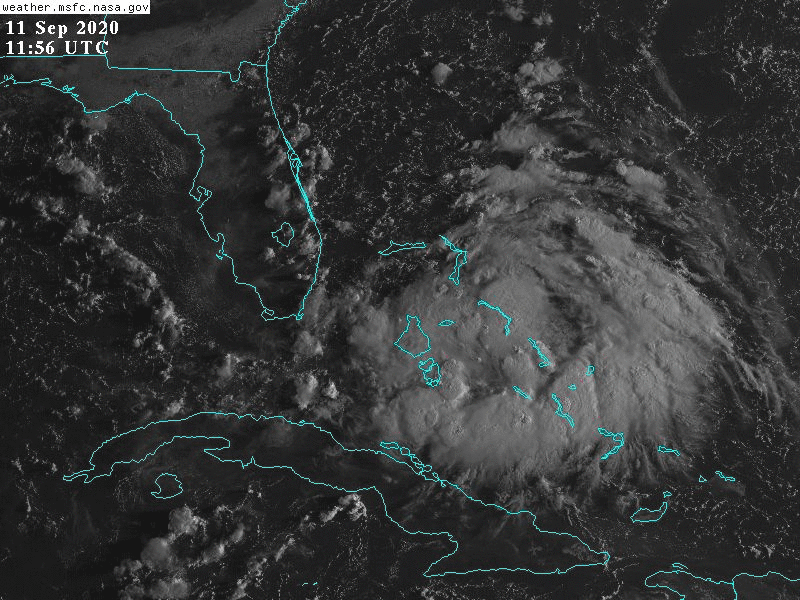
Finally, there's a small disorganized disturbance that formed along a frontal boundary over the weekend... it's centered over western Cuba and south Florida, and is not forecast to move much. Development is very unlikely, but it will make for some breezy and rainy conditions in the region for a day or two. In the infrared satellite image at the top of the post, it's hard to distinguish it amidst the rest of the active front draping down from Teddy.

With the surge of activity lately, the ACE (Accumulated Cyclone Energy) has jumped up to about 147% of average for the date. But it still doesn't touch the values from some of the mega-seasons of the past through September 21 -- the top five through this date are 1933, 2004, 1995, 1926, and 2017.


Elsewhere across the basin, things look quiet for the foreseeable future. But when the time comes, the next names on the list are Gamma and Delta.


19 September 2020

Now two names into the Greek list, and watching five storms

For the first time since 1893, THREE named storms formed in one day: Wilfred, Alpha, and Beta. When I started writing yesterday's blog post, Wilfred had just formed. Shortly after publishing it, Alpha formed, and a few hours later, Beta formed. I certainly can't recall anything like this happening in my 25 years of writing these posts! And to keep it even more interesting, Teddy's still a Category 4 hurricane and ex-Paulette is still out there and has a decent chance of re-developing.


Rather than discussing these in alphabetical order, I'll start west and go east. Tropical Depression 22, which had been festering for a long time in the western Gulf of Mexico, was upgraded to Tropical Storm Beta on Friday afternoon.  It is forecast to intensify to the season's ninth hurricane shortly as it drifts northwest toward Texas. The map below shows the NHC forecast track, the various tropical storm/hurricane watches and warnings, and the probability of tropical storm force winds.


But the hurricane part isn't the problem... it's the drifting. Models have been indicating that Beta will stall near the Texas coast and produce tremendous amounts of rainfall in the coming days.  It's essentially a toned-down version of Harvey in 2017 (that was a Category 4 hurricane at landfall and then stalled further north for several days). There's still uncertainty in the track of course, so the exact placement of rainfall maxima is impossible to know this far out, but a large swath of eastern Texas and Louisiana should be preparing for significant flooding.


On to Teddy... tropical storm warnings have been issued for Bermuda as the Category 4 hurricane approaches.  Teddy will pass east of the island and spare it from a second major impact in one week, but tropical storm conditions are possible as it zips by on Monday. But then, there's strong agreement among models that it will slam into Nova Scotia on Tuesday, possibly still with hurricane-force winds (even if it's technically not a hurricane anymore).


As expected, Tropical Storm Wilfred is battling a hostile environment and will likely not be around much longer. It's very disorganized and should dissipate by Sunday or Monday. This is something that might seem strange: a dissipating tropical storm in the heart of the deep tropics in mid-September. This fits in with what I'll discuss at the end of the post: lots of storms but they don't last long.


Moving on to Subtropical Storm Alpha, which made landfall on Portugal's coast on Friday night and has since weakened. This formed from an extratropical low pressure system that NHC began watching for development last Monday night, so it certainly didn't come out of nowhere, but the uncertainty was around whether or not it would acquire subtropical or tropical cyclone characteristics before reaching land -- it did, briefly. As a result, it got named, and Portugal got to usher in the use of the Greek alphabet for Atlantic storms this year.


And finally, we're still keeping an eye on what was Hurricane Paulette.  This isn't too surprising though, as many models had been suggesting that it would make a sharp turn to the south and return to warmer waters and possibly regain tropical cyclone characteristics. The turn happened, but the tropical transition has not happened yet. It's presently near the Azores, and has tropical storm-force winds. It also has a lot of smoke from the California wildfires wrapping into the circulation, which shows up here as the milky colors.


Don't believe me?  Using NOAA's HYSPLIT model, here's a backward trajectory that I calculated starting at Paulette's present location and going back eight days... the smoky air wrapping into Paulette came directly from southern California.


Wilfred, Alpha, and Beta are the season's 21st, 22nd, and 23rd named storms, which puts this season an incredible 33 days ahead of 2005's record pace. But, 12 of the 23 named storms this year were around for three days or less, and only 2 of the 23 were major hurricanes (Laura and Teddy).

So in terms of ACE (Accumulated Cyclone Energy), the average ACE per storm through today in 2020 is 3.8, while at this point in 2005, it was 8.7.  And at this point in 1933, the average ACE/storm was 15.2!

In fact, 2005 isn't even in the top five ACE producing years as of today... the top five are 1933, 1995, 2004, 1926, and 1950. But as of September 19, the ACE is 136% of average for the date -- a big spike after being near-average just a week ago. As you can see below, it's really comparable to 2018 and 2019 as of today.

18 September 2020

Wilfred and Alpha form in eastern Atlantic

For only the second time in history, the list of Atlantic tropical cyclone names has been exhausted. The wave in the eastern Atlantic was upgraded to Tropical Storm Wilfred on Friday morning.  This is the 21st named storm of the season, and is now three *weeks* ahead of 2005's record pace.


In the near term, Wilfred is expected to strengthen just a bit more, but then environmental conditions should become rather hostile by Monday, and the official forecast actually shows it dissipating in the deep tropics over the central Atlantic early next week.


Teddy has continued to intensify and is now a powerful Category 4 hurricane.  It's headed in the general direction of Bermuda, and should pass just east of the island on Sunday night.


Beyond the Bermuda encounter, it appears very likely that it will impact Nova Scotia as a strong hurricane (or extratropical cyclone with hurricane-force winds) on Tuesday.  The last few hurricanes to hit Nova Scotia were Dorian (2019), Earl (2010), Kyle (2008), and Juan (2003). 


Surprisingly, a low pressure system off the coast of Portugal developed today too, and is now Subtropical Storm Alpha.  This is the 22nd named storm of the season, and thus the first one to use the Greek alphabet! This won't around very long, but it certainly is interesting... the last subtropical storm to hit Portugal was Leslie in 2018.


We are also really close to having Tropical Storm Beta in the western Gulf of Mexico.  It's currently Tropical Depression 22, and models have been trending stronger.  The NHC forecast brings it up to hurricane intensity on Sunday and Monday as it drifts north, but then *possibly* weakening back to a tropical storm on Tuesday as it nears the Texas coast and slows to a crawl.


Unfortunately, regardless of just how intense it gets in the coming week, the rainfall will be very significant: this map below shows the rainfall forecast through next Friday. The sluggish motion will allow it to rain over the same locations for days.


Elsewhere, there is not much worth monitoring at this time.


16 September 2020

Sally makes landfall, Teddy upgraded to hurricane, Vicky weakens


For a few hours on Wednesday morning, the Atlantic basin was buzzing with three Category 2 hurricanes (Paulette, Sally, Teddy) and one tropical storm (Vicky).  Since my previous post on Monday afternoon, Sally weakened a bit on Tuesday but then intensified to a Category 2 hurricane as it made landfall on Gulf Shores, AL in the early morning hours on Wednesday. This is the *8th* named storm to make landfall on the mainland United States this season already... a new record.


The storm's slow forward motion continued through landfall (literally moving slower than a walking pace), creating tremendous flooding in parts of Alabama and the Florida peninsula.  I have long radar loops available at http://bmcnoldy.rsmas.miami.edu/tropics/radar/. Sally will continue to produce heavy rain along its track for the next several days, so the inland portion of its journey is just beginning.


Sally also generated something we tend to gloss over when it comes to hurricane impacts: the "anti-surge".  Storm surge is when strong onshore winds essentially and relentlessly bulldoze water onto land, often resulting in very destructive flooding.  But what about when the offshore part of the eyewall passes over a body of water? Well, Sally's western eyewall did just that: it passed over Mobile Bay and pushed a LOT of water out of the bay. At this tide gauge near Mobile, the water level fell 8 FEET as Sally made landfall, and then the water was eventually allowed to rapidly flow back into the bay. Of course, areas that experienced the eastern eyewall got the opposite effect.

Paulette was a hurricane up until midday Wednesday when it was officially transitioned from a tropical cyclone to an extratropical cyclone, at which point, NHC ceases advisories (though it's still a powerful low pressure system with hurricane-force winds!).

Vicky has remained a low-to-mid grade tropical storm, but is now weakening in the face of increasing wind shear (generated by Hurricane Teddy's outflow), and is expected to dissipate by the weekend.

Teddy has rapidly intensified to a Category 2 hurricane and is forecast to strengthen even more this week.  It's presently located about 750 miles east of the Windward Islands, 1350 miles southeast of Bermuda, and is moving toward the northwest at 12 mph. Models are in excellent agreement on a track toward the northwest, which unfortunately brings it to Bermuda on Monday -- they just got a direct hit from Category 2 Hurricane Paulette this past Monday!  Bermuda is the tiny cyan speck in the upper left corner of the satellite image below (can you find it?).


Then there are a couple areas of interest to monitor in the coming days. One is an easterly wave just south of Cabo Verde (Invest 98L). It's worth watching, but as of now, it faces a grim future according to long-range models.  While it's fairly likely to become at least a tropical depression in the coming days, the outlook as we head into early next head appears to include a more hostile environment for it. It's marginal though, with a few models showing continued development -- not an urgent threat to anyone.


The other is a disturbance in the western Gulf of Mexico (Invest 90L). It is in an area of virtually no steering flow, so it should just sit in place and gradually get organized.  What does the future hold for it? No model has a useful or consistent forecast, so for now, we wait and see what it does.


Only one name remains in the regular list: Wilfred.  After that, we start using names from the Greek alphabet: Alpha, Beta, Gamma, Delta, etc.  You may recall that the hyperactive 2005 season went into the Greek alphabet too, but not until October 22.  In terms of ACE (Accumulated Cyclone Energy), this recent burst of action has taken the season from near-normal a few days ago to about 125% of normal for this date.


As mentioned before, while the 2020 season is blasting its way through names, it's far from competing with previous hyperactive seasons in terms of ACE. The top five historical seasons as measured by ACE through September 16 are: 1933, 1995, 2004, 1950, and 2005.

14 September 2020

Sally now a hurricane, Teddy and Vicky form

It is almost impossible to keep up with the amount of activity in the Atlantic right now.  If you're confused about what storms are out there and which ones are where, you are not alone.  As of Monday afternoon, there is Hurricane Paulette, Tropical Depression Rene, Hurricane Sally, Tropical Storm Teddy, and Tropical Storm Vicky. This is an extraordinary amount of simultaneous tropical cyclones. There are also a couple areas of interest to monitor for future development.


The rate at which 2020 is burning through names continues to be unrivaled. This year has now set the record for the earliest C, E, F, G, H, I, J, K, L, M, N, O, P, R, S, T, and V storms!  In 2005, the regular list was exhausted and we switched to the Greek alphabet on October 22... that could happen a full month earlier in 2020.

Let's go through the active storms in alphabetical order.

Hurricane Paulette made a direct hit on Bermuda early on Monday morning as an upper-end Category 1 hurricane.  It is now a Category 2 hurricane and still strengthening as it pulls away from the island and heads toward to the northeast in the coming days.  This infrared satellite image is from 0900 UTC today, and that little white outline inside the eye is Bermuda!


Tropical Depression Rene is technically still active, but is expected to dissipate later today.

Hurricane Sally is of great concern along the northern Gulf of Mexico coast.  Not surprisingly, after exiting the southern Florida peninsula on Saturday, it began to strengthen and get more organized. But during Monday, it has really exploded and is rapidly intensifying. To make matters worse, it's also slowing down.  Not only does that give it more time over water prior to landfall, but it also increases the amount of rain that can fall.


The storm is slowing down to the point where "landfall" loses much of its meaning... rather, it will ooze onto land, drifting in at a walking pace and dumping perhaps two feet of rain, and generating a 7-11 foot storm surge that will span multiple high tides. But the center is expected to come in somewhere from the mouth of the Mississippi River to eastern Mississippi, and since it's already almost a Category 2 hurricane, it's not unreasonable to have it be a Category 3 by Tuesday afternoon. The center should be inland by Tuesday evening. 


Tropical Storm Teddy is located about 1200 miles east of the Lesser Antilles and is forecast to become a very strong hurricane in the coming days, but will turn toward the northwest early enough to avoid hitting the Windward Islands.


And last but not least, the wave we were watching near Cabo Verde was upgraded to Tropical Depression 21 early Monday morning, then again to Tropical Storm Vicky later in the day.  This the season's 20th named storm, and it's only September 14!!


There is another tropical wave just off the African coast today, and there is a decent chance that it will develop too... the next -- and final -- name on the regular list is Wilfred.  After that, we switch to the Greek alphabet: Alpha, Beta, Gamma, Delta, Epsilon, Zeta, Eta, etc.


13 September 2020

Looking ahead to two hurricane landfalls in one day with Paulette and Sally

The Atlantic continues to be crowded with active tropical cyclones: Tropical Storm Sally in the Gulf of Mexico, Hurricane Paulette southeast of Bermuda, Tropical Depression Rene and Tropical Depression Twenty in the central Atlantic.


The two landfalls coming up soon are Paulette (Bermuda on Monday morning) and Sally (Louisiana on Monday night). Both storms are forecast to be Category 1-2 hurricanes when they make landfall.

Starting with Sally, a very serious situation is unfolding -- a strengthening storm slowing down as it nears the coast will exacerbate storm surge and rainfall flooding.  Hurricane, tropical storm, storm surge, and flood warnings stretch across much of the northern Gulf coast now. Landfall will be drawn out from Monday night into Tuesday afternoon, so the storm surge will span multiple high tides and tremendous rainfall will create significant flooding.

In the coastal areas near New Orleans, a 7-11 foot storm surge is possible, and the southeast Louisiana into western Florida panhandle area could see up to two feet of rain. This combination will stress and strain the levee system protecting New Orleans, so hopefully everything holds. There are radar loops covering this area at http://bmcnoldy.rsmas.miami.edu/tropics/radar/


Paulette was upgraded to the season's 6th hurricane on Saturday night (local time) and is headed directly for Bermuda. As of this writing, it's a Category 1 hurricane, but further strengthening is expected as it reaches the island and then turns toward the northeast. It could easily reach Category 2 intensity by the time it makes landfall, and then Category 3 after that. I have two updating radar loops from Bermuda at http://bmcnoldy.rsmas.miami.edu/tropics/radar/

The two depressions are at different phases of their lives: Rene is about to dissipate, while Twenty is on the verge of becoming Tropical Storm Teddy.  Neither is close to impacting anything, and Teddy, in the longer-range forecasts, is expected to turn toward the northwest well before reaching the Lesser Antilles. I will just mention them in this post... more attention can be diverted to Teddy once the landfalling storms have passed.  Rene will probably be gone by that time.

Through the end of the 13th, the ACE (Accumulated Cyclone Energy) is hugging the average value -- just 2.5% above average using the past fifty years as the baseline.


To put that value in historical context, the value today is about 56, while eight years in the known records had values over 120 by this point in the season (2017, 2005, 2004, 1950, 1933, 1899, 1893).  This season only holds the record for the most named storms by this date.


12 September 2020

Now up to FOUR active tropical cyclones in the Atlantic, soon to be five

We still have a strengthening Tropical Storm Paulette, a weakening Tropical Depression Rene, recently-upgraded Tropical Storm Sally, and newly-formed Tropical Depression Twenty. And just to keep something in the queue, Invest 97L is out there in the far eastern Atlantic too.  In order from west to east, it's Sally, Paulette, Rene, TD20, Invest 97L.  It's a lot to keep straight, but here it goes.

An active scene across the Atlantic: two tropical storms (red), two tropical depressions (blue), and one Invest (yellow).

Invest 96L, the one that was over the Bahamas yesterday, was upgraded to Tropical Depression 19 on Friday afternoon, and then again to Tropical Storm Sally on Saturday afternoon -- immediately upon exiting the southern Florida peninsula.  This is the earliest 18th named storm by an incredible 20 days!!  

Sally organized relatively quickly, from a marginal tropical depression to a strengthening tropical storm in a day... but that day was spent mostly over land!  While the wind has expectedly not been a big problem, very heavy rain has fallen in the Florida Keys on Saturday... relentlessly.


The center is over the Gulf of Mexico now, and land interaction will become a decreasing influence, so it is fully expected to strengthen more. The official forecast from NHC brings it to Category 1 hurricane status on Monday, prior to landfall in the LA-MS-AL area, but there is some model support for more aggressive intensification. A hurricane watch is in effect for that area of the coastline. Sally is forecast to slow down as it approaches the north-central Gulf coast, making heavy rain and flooding a larger-than-average concern for the area.

Next in line is Paulette... en route to Bermuda. This strengthening tropical storm is forecast to make a direct hit on the tiny island on Sunday night into Monday morning, as at least a Category 2 hurricane. After that, it will turn toward the northeast and head into the north-central Atlantic as a potent extratropical cyclone by next weekend.  The last few hurricanes to impact Bermuda were Nicole (2016), Gonzalo (2014), Fay (2014), and Igor (2010).


Next is Rene, which fortunately does not offer much to talk about.  It is a small and very weak tropical depression located well to the southeast of Paulette.  It will probably linger around for a few more days as a depression, but is not expected to make a comeback.

Then we have Invest 95L which was just upgraded to Tropical Depression 20 on Saturday afternoon. It is poised to become Tropical Storm Teddy soon, which would make it the 19th named storm of the season.  This is centered about 2000 miles east of the Lesser Antilles and moving slowly toward the west-northwest at 9 mph.

Over the past few days, models have come into better agreement on this turning toward the northwest long before reaching the Antilles... at this point, it would be hard to see things changing significantly back the other way with a track into the Caribbean.  There is also consensus among the models that this will intensify into a hurricane in 2-3 days, and possibly a very strong hurricane. We will need to keep one eye on this in the coming days (I realize we're going to run out of spare eyes) just to watch for trends in the ensembles regarding that northward turn.

And finally, the wave that exited the African coast a couple days ago is now located near the Cabo Verde islands and has a good chance of becoming a tropical depression or storm in the next 2-4 days.  If this gets named, the next name after Teddy is Vicky (and at that point, only Wilfred remains until we dig into the Greek alphabet).


11 September 2020

Still watching Paulette and Rene, but Sally and Teddy are on the horizon


Tropical storms Paulette and Rene are lurking in the central Atlantic.  Paulette is far more impressive, while Rene is almost hard to spot. Their futures will be quite different too.


Rene may linger for several more days as a weak tropical storm, but Paulette is forecast to become a strong hurricane and perhaps threaten Bermuda by Monday.


Aside from Paulette and Rene, there is the strong wave over the Bahamas heading for Florida then the Gulf of Mexico, and the strong wave near Cabo Verde in the far eastern Atlantic. Both could be named in the coming days, and the next two names are Sally and Teddy.  Another wave is just about to leave the African coast today, but I won't discuss that one any further yet in the interest of length.

The wave over the Bahamas is presently identified as Invest 96L, but could soon be transitioned to Potential Tropical Cyclone 19 (they are the same thing, but classifying an Invest as a PTC gives NHC the ability to issue tropical storm watches/warnings for it before it forms) or upgraded to Tropical Depression 19.


It will drift across the Florida peninsula this weekend, producing widespread heavy rain, then enter the eastern Gulf of Mexico where it is expected to get better organized and strengthen.  There's a slight chance that it could develop into a tropical depression near or over south Florida on Saturday. As of now, the guidance has been showing a turn toward the north after Florida, bringing it into the north-central Gulf coast around Monday-Tuesday.

While there is not any indication from the model guidance that it would be more than a tropical storm, conditions in the eastern and central Gulf appear ideal for it to strengthen, so time will be the primary limitation. The map below shows the total rainfall forecast through the coming week.


Much further east, Invest 95L is located near Cabo Verde, and is a broad, elongated, and disorganized system. Although it's disorganized now, there is full model support for this becoming a hurricane further west in the deep tropics. Then, in about 4-5 days, there is a big jump in the track uncertainty.


For a disturbance that has not yet even a tropical cyclone, we expect the models to have challenges with the forecast.  The two sets of ensemble forecasts shown below are from the European model (left) and the American model (right).  In general, the majority of solutions favor a turn to the northwest before reaching the Lesser Antilles. But of the ones that reach the Antilles, it reaches the islands on Wednesday-Thursday, and it could be a strong hurricane.


As of today, the ACE (Accumulated Cyclone Energy) is at about 101% of average for this date, using the past 50 years as the baseline.  Twelve years have had more than twice this value by now, and a couple infamous years in the past have had three times this value by now: 1933 and 1995.