This post marks the end of my 26th year writing these updates on tropical Atlantic activity. During that time, I have written approximately 1350 posts spanning 444 tropical cyclones, 197 hurricanes, 92 major hurricanes, and 50 retired storm names. I was honored to have been invited to write for the New York Times' hurricane blog from 2007-2010, and then for the Washington Post's Capital Weather Gang since 2012. I truly appreciate your continued interest!
The 2021 Atlantic hurricane season is the sixth consecutive season with above-average activity: there were 21 named storms, 7 of which became hurricanes, and 4 of those became major hurricanes (Category 3+). The average values of those quantities are 14, 7, and 3.
2021 was only the third season to ever exhaust the regular list of 21 names... the other two times being 2005 and 2020. It was also the seventh consecutive season with a named storm formation prior to the official start of hurricane season on June 1, helping to pull the trendline earlier when we look back on the past fifty years of first named storm formation date.
The Accumulated Cyclone Energy (ACE) was above-average all season long, and blew past a full average season's total on September 28th -- it ended up at about 141% of average (using 1971-2020 as the baseline climatology). Rather than counting the number of storms, ACE is a metric that accounts for the overall intensity and duration of whatever storms there are.
The ACE was above 129 units for the sixth consecutive year -- this has never happened before, not during the satellite era, not since records begin in 1851. This sustained level of tropical cyclone activity in the Atlantic is unprecedented even for four years, let alone six!
Hurricane Larry and Hurricane Sam were the heavy hitters of the year by this measure... Larry contributed 33% of the season's total and Sam contributed 37% of the total. The storm in third place is way down at 7%, and that was Ida. It is worth mentioning that 9 of the 21 named storms were only around for two days or less, and they contributed just 4% of the season's ACE, combined.
As you can see on the chart above, the burst of activity in late September came to an abrupt end on October 5th. The lone straggler was Tropical Storm Wanda which was around from October 31st to November 7th, and formed from a former Nor'easter. It's extremely rare and peculiar to have an active season essentially shut down in the first week of October!
Although still preliminary, the 2021 season is the 4th costliest Atlantic hurricane season, behind 2017 (1st), 2005 (2nd), and 2012 (3rd). The economic losses are expected to exceed $70 billion, bumping the fresh-in-our-memory 2020 season down to 6th place.
Drilling down to individual storms, Ana formed prior to the official start of the season, on May 22, as referenced above. Bill formed off the southeast U.S. coast and headed out over the open ocean. Claudette, Danny, Elsa, and Fred all made landfall on the U.S. mainland.
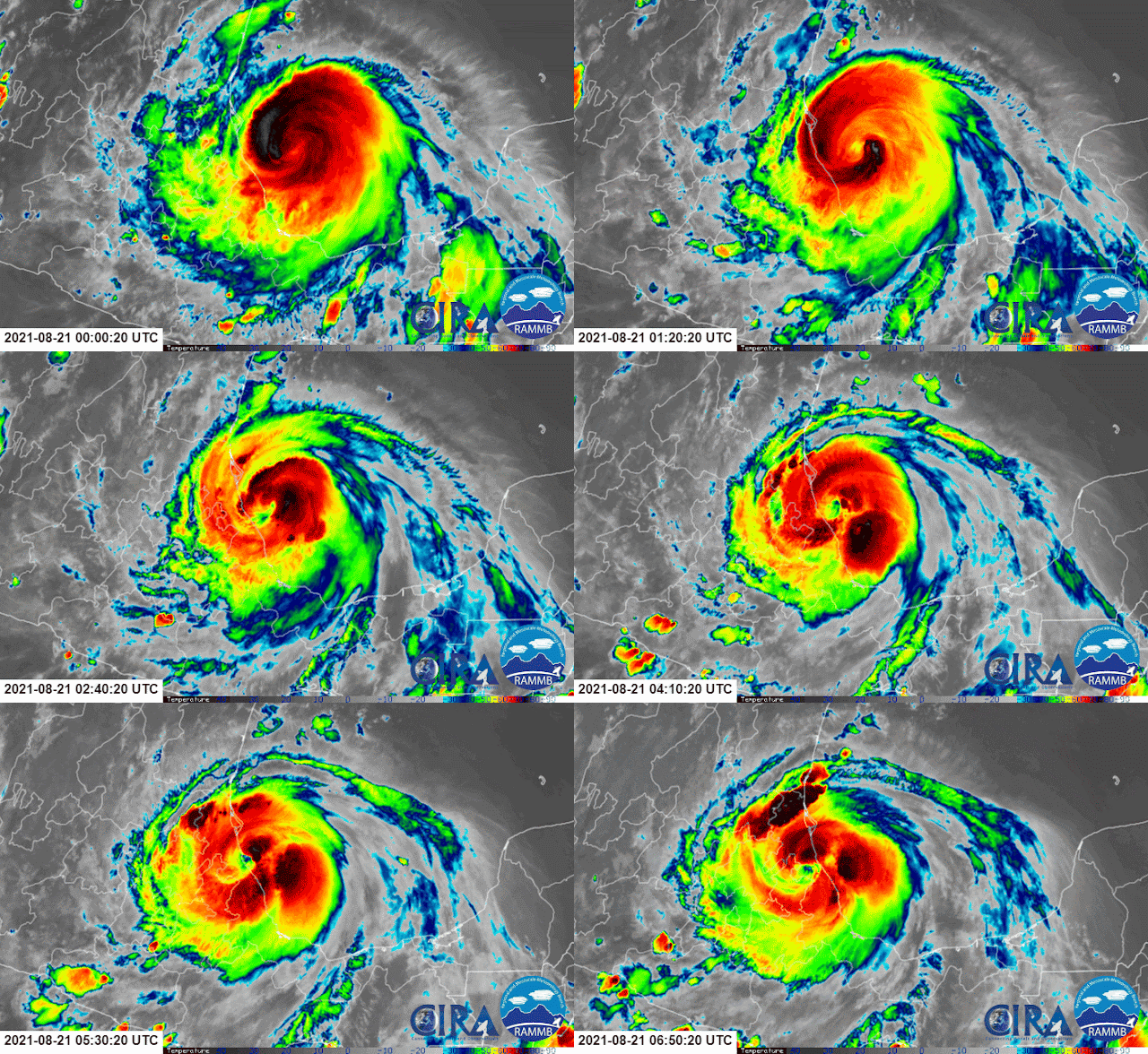
Grace was the season's first major hurricane, reaching Category 3 intensity right as it made landfall in Mexico near Veracruz.
 |
| Enhanced infrared satellite animation of Category 3 Hurricane Grace making landfall on August 21st. |
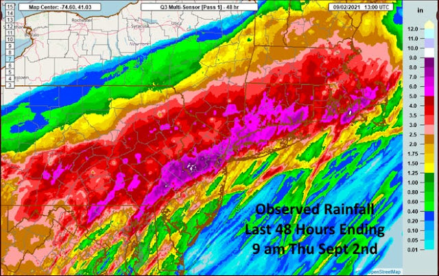
Hurricane Henri was quite impactful in the northeast U.S. when it made landfall in New England on August 22nd as a tropical storm. It caused widespread power outages and produced record-breaking rainfall in New York City and flash flooding across several states. This same area would be impacted with more heavy rain by Ida in just over a week.
 |
| A full-resolution version is available at http://bmcnoldy.rsmas.miami.edu/tropics/radar/ |
The most intense of the landfalling storms was Hurricane Ida, which made landfall near New Orleans on August 29th, on the 16th anniversary of Hurricane Katrina's landfall in the same location. It was a Category 4 hurricane, reaching peak intensity right as it made landfall. Its strong winds and storm surge caused extensive catastrophic damage across southern Louisiana.
 |
| A full-resolution version is available at http://bmcnoldy.rsmas.miami.edu/tropics/radar/ |
As usual, Ida's trail of destruction didn't end at the coastline. Three days after landfall, post-tropical cyclone Ida interacted with a mid-latitude trough and a very focused band of extreme rainfall was the result. Although the event was remarkably well-forecast days in advance, rainfall totals in PA, NJ, and NY and then into southern New England were incredible, devastating, and deadly.
Ida was responsible for 115 fatalities and over $65 billion in damages from Venezuela and Colombia, then Jamaica and Cuba, and finally the United States. It's always tempting to "write off" a hurricane after landfall, but in fact, there are often several days of severe impacts remaining as it moves inland... quite far from where it made landfall. Ida is tied with 2012's Sandy as the 4th costliest hurricane in U.S. history.
Moving ahead, Larry was a long-track major hurricane, and a named storm for 10.5 days. It clipped Newfoundland at the end of its journey on September 11th, causing fairly significant damage, and rip currents associated with it killed two people in Florida and South Carolina.
Like Grace and Ida, Nicholas reached its peak intensity right at landfall -- near Galveston TX on September 14th as a Category 1 hurricane.
The strongest storm of the season was Sam, which fortunately remained over water in the central Atlantic. It was a named storm for 12 days, nearly 8 of which were spent above Category 3 intensity! It also produced the fifth most ACE of any Atlantic hurricane on record (https://twitter.com/BMcNoldy/status/1445428509220892673)!
 |
| Hurricane Sam on September 26th, when it was just a click away from reaching Category 5 intensity. |
Keep in mind that all statistics presented here are preliminary; the National Hurricane Center will have the final post-season reanalysis of all storms complete in a few months. We will also find out which names will be retired early next year. But we can reasonably anticipate that Ida will be retired, so I will offer these following updated charts with that in mind (and not knowing if any other names will be retired from this season). Ida's all-but-certain retirement puts "I" storms even more in the lead, as well as retired storms that peaked at Category 4 intensity. (The colors on the bars are only scaled by value for the sake of visual interest.)
Next year's name list starts off with Alex, Bonnie, and Colin. Two new names appear on the 2022 list: Martin and Owen, which replace Matthew and Otto from 2016.


