23 July 2021

Disturbance off southeast US coast likely just a rainmaker

Forecast rainfall totals through Monday morning.

A low pressure system is centered about 150 miles east of the Georgia-Florida border, right over the core of the toasty Gulf Stream.  It actually originated over land, drifted east, then got a boost from the warm Atlantic water and is now tagged as Invest 90L.  It's facing some fairly hostile environmental conditions, so the odds of development are slim (30% from NHC), but it will bring a lot of rain and risk of flooding to Florida in the coming days.


The image below shows "precipitable water", or the water content of the atmosphere, and is great at illustrating where the deep dry air is (blues) and where the moisture envelope associated with the disturbance is (dark reds).  It also reiterates the point about how elongated and disorganized the system is.


The disturbance is forecast to head back west across the Florida peninsula over the next few days, and eventually dissipate.  There's not much in the way of model guidance that supports development of this, so we certainly aren't expecting it to become a tropical storm, but if it should beat the odds, the next name on the list is Fred.  Elsewhere across the basin, it is very quiet, and probably will remain quiet until early August.

09 July 2021

The 18.6-year Lunar Nodal Cycle: What it is and why it matters

"Right now, we’re in the phase of an 18.6-year lunar cycle that lessens the moon’s influence on the oceans. The result can make it seem like the coastal flooding risk has leveled off, and that can make sea level rise less obvious."
I want to share an article that I wrote for The Conversation back in April, before an upcoming perigean full moon.  The article isn't related to hurricanes, but to another topic that I have an interest in: sea level rise.  I hope you don't mind this brief excursion.  Of course, water levels and hurricanes do share one thing in common: storm tide, the combination of the "normal" tide level and storm surge.  So perhaps this is more of a tangent than an excursion?


The topic is the 18.6-year lunar nodal cycle, and the article describes what it is and why it matters.  It was first documented hundreds of years ago, so it's hardly "news".  But this very normal and regular oscillation in Earth's tides is superimposed on sea level rise, and that is becoming a bigger and bigger concern and problem around the world as the decades tick by.

"The effect of the nodal cycle is gradual – it’s not anything that people would notice unless they pay ridiculously close attention to the precise movement of the moon and the tides for decades.

[But] it’s worth being aware of this influence, and even taking advantage of it. During the most rapid downward phase of the lunar nodal cycle – like we’re in right now – we have a bit of a reprieve in the observed rate of sea level rise, all other things being equal. These are the years to implement infrastructure plans to protect coastal areas against sea level rise.

Once we reach the bottom of the cycle around 2025 and start the upward phase, the lunar nodal cycle begins to contribute more and more to the perceived rate of sea level rise. During those years, the rate of sea level rise is effectively doubled in places like Miami."

The full article is available on The Conversation:


Related:


08 July 2021

Elsa's extraordinary place in history

Elsa ended up making landfall just north of Steinhatchee in Florida's Big Bend area as a strong tropical storm on Wednesday morning, after briefly regaining hurricane status west of Tampa.


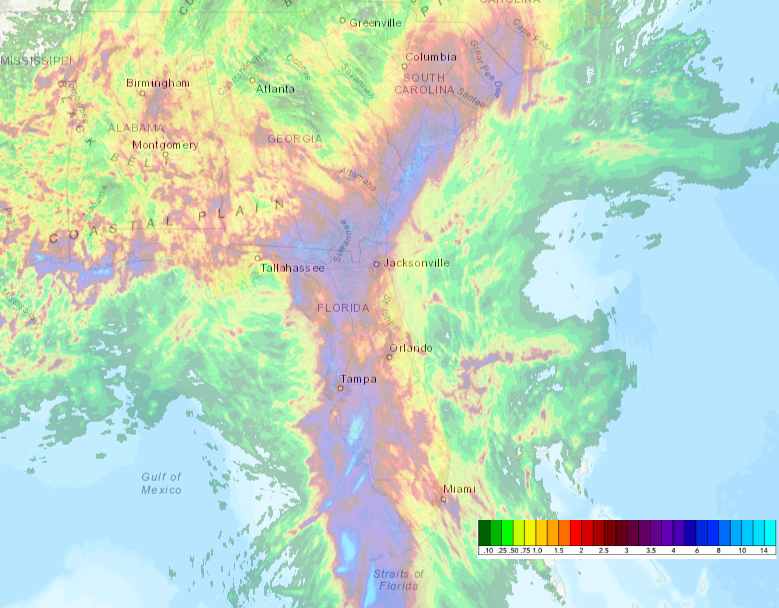
The heavy rainfall has been the biggest concern, and will continue to be as it passes through the Carolinas and off the mid-Atlantic coast over the next couple of days.  The first map below shows the observed rainfall over the past three days (since Monday morning).  The swath of highest totals includes the west coast of the Florida peninsula, then up into coastal Georgia and South Carolina.


And next is the outlook for flash flood risk over the next three days:


But this post's primary purpose is to highlight just how rare of an event we just witnessed.  In the scope of a full hurricane season, a storm like Elsa is not rare at all, but for early July, it is absolutely extraordinary.  The official database of Atlantic tropical cyclones goes back to 1851, or 170 years.  We've only had the benefit of routine weather satellite coverage for the past 50 years or so, but prior to that, we had aircraft surveillance, and prior to that, we had lots of ship traffic and land-based observations.

Elsa traveled through the eastern Caribbean Sea as a hurricane in early July.  The only other years to have that happen were 1933 and 2005, literally the two most active hurricane seasons on record.  It's quite unlikely that hurricanes were missed in or near the Lesser Antilles even 170 years ago.  In other words, I think that is a robust record and a very rare event.  Such an event becomes far more common later in the season, but climatologically, we just don't get the strong African easterly waves yet, or favorable environmental conditions to allow their development.


There's also a more fuzzy record that Elsa set: the earliest 5th named storm on record.  That record was just set last year on July 6th, 2020, and then broken again on July 1st, 2021.  This record also applies to the full 170-year database, but I call it fuzzy because it's certainly possible that small, remote, weak, and/or short-lived storms were missed prior to the satellite era, or even prior to the past couple decades with better observing technology.  

Finally, through July 8, the Accumulated Cyclone Energy (ACE) is an incredible 375% of the average over the past fifty years.  In the past 170 years, it's the 12th highest value by this date, and in the past 50 years, it's the 2nd highest (2005 is 1st).

This chart below includes the annual totals of ACE since 1851 (orange bars), and the ACE totals only through July 8th (purple bars).  I plotted them on a logarithmic axis so we can actually see the little values along with the big values, and I highlighted and labeled the 11 years that had higher ACE as of July 8.  Not every year with an active beginning ended up being hyper-active, but some of the most hyper-active seasons had active beginnings.


There are currently no other areas of concern, but when the time comes, the next name on the list is Fred.

05 July 2021

Elsa makes landfall in Cuba, Florida is next

Tropical Storm Elsa made landfall near the Bay of Pigs in Cuba on Monday afternoon with peak sustained winds of 60 mph, but the torrential rainfall was a far bigger concern across much of the country.  It will traverse a narrow part of Cuba in short order, and be back over the warm water by Monday night as it heads for the Florida Keys then north.  It is not expected to regain hurricane strength prior to its final landfall on Wednesday morning in Florida's Big Bend region.


The official forecast has remained pretty steady, and has done really well -- the strong competing forces of extremely warm ocean water and lots of land interaction have kept it intact but not able to intensify much.  Rainbands are already spreading across south Florida, and will continue to do through Tuesday.  This radar loop and several others can be found at http://bmcnoldy.rsmas.miami.edu/tropics/radar/.


Not surprisingly, the wind is not a huge concern with a tropical storm, but the storm surge could get rather bad (up to 5 feet?) in the Big Bend and Tampa Bay areas because they are so geographically vulnerable to surge.  Since it's still moving at a decent speed, the rainfall shouldn't be too bad... some areas will experience flooding (particularly in the western Florida peninsula), but generally under six inches is expected.  It is forecast to decay over land as it tracks over Georgia, the Carolinas, and up the northeast coastline over the next 4-5 days.


As I eluded to earlier, the track and intensity forecasts so far have been exceptional, with errors well below the NHC's own average over the past five years at nearly every lead time.  These plots show each individual NHC forecast (colored lines) as well as the observed position/intensity (black line).  


Elsewhere across the basin, no new activity is expected in at least the next several days.  But through today, the ACE (Accumulated Cyclone Energy) is an impressive 352% of average for the date, using the past fifty years as the baseline.  A handful of other years were that active so early in the season, most recently 2012, 1968, and 1966. For reference, 2020 was only about 2/3 of where 2021 is at. 


03 July 2021

Elsa weakens as it approaches Cuba


Elsa now holds the record as the fastest-moving hurricane in the tropics, during the reliable weather satellite era.  It set that record at 27 mph (beating Hurricane Debby in 2000), but it broke its own record when the forward motion increased to 31 mph on Saturday morning. Records aside, that rapid forward motion actually introduces vertical wind shear across it, which has played a big role in Elsa's weakening on Saturday. 

As of the 5pm EDT advisory, Elsa is a tropical storm with peak winds of 70 mph, and it's racing toward the west-northwest at 28 mph. In addition to the self-induced wind shear, it is also really close to the mountainous southern coast of Haiti.  That combination has taken its toll on the storm's structure, and the upcoming trek across Cuba will be another hit.  Watches and warnings are plastered over Hispaniola, Jamaica, and Cuba, and now the Florida Keys too.


The first tropical storm watches should be issued for more of south Florida tonight, but we already have the routine HTI (Hurricane Threats and Impacts) graphics which break the risks down by the four major hazards associated with tropical cyclones: wind, rain, storm surge, and tornadoes.  The "cone of uncertainty" is overlaid in blue for reference. Always remember that the cone IS NOT an impacts cone (Cone Refresher).


The forecast is still tricky because of the land interaction; that's always a challenge for models and human forecasters alike.  But assuming that it emerges even remotely intact, it is likely to bring wet and stormy conditions to south Florida starting on Monday.  Based on the latest NHC forecast, tropical storm conditions could begin in south Florida midday Monday, as well as the onset of several inches of rain.  It looks very likely that the west coast of the peninsula will experience worse conditions than the east coast (stronger winds, heavier rain, and more storm surge), but folks along the east coast need to be prepared for some stormy weather from midday Monday through Tuesday evening.

One other tidbit that I dug up on Friday afternoon is that there has only been a hurricane in the eastern Caribbean before mid-July in two other years: 1933 and 2005.  Ominously, those two years are the record-holders for the highest ACE (Accumulated Cyclone Energy) in a season.


For those who like to keep track of the ACE as the season progresses, 2021 is now at 293% of average, using the past fifty years as the baseline for the average.  The last season that was so high by this date was 2012.


02 July 2021

Elsa becomes first hurricane of the season over Barbados


On Friday morning, Elsa was upgraded to the first hurricane of the season, just as it was passing over Barbados. A hurricane watch is now in effect for Haiti, and a tropical storm watch for Jamaica, among closer, more immediate locations in the Lesser Antilles.

This short satellite loop shows the impressive structure since sunrise, and I have a couple radar loops available at http://bmcnoldy.rsmas.miami.edu/tropics/radar/


It is forecast to continue moving quickly to the west-northwest, reaching the Haiti area on Saturday, then Cuba on Sunday.  The forecast gets extremely challenging then, as the models diverge greatly on both track and intensity.  The extent of interaction with Haiti and Cuba is what drives most of the spread.  But leading up to then, some models, like the European global model, actually dissipate it, while the HWRF regional hurricane model brings it just to Category 3 hurricane intensity.  Somewhere in between is the most likely, and that is what the NHC forecast represents.

For interests in the U.S. mainland, the first area of concern is south Florida.  IF Elsa should maintain itself as a tropical storm or hurricane and it tracks toward Florida, impacts would begin midday Monday, with a closest approach late Monday night into Tuesday morning.  Model guidance overwhelmingly shows it at tropical storm intensity at that point.


If it passes west of the Florida peninsula as the majority of models show, it would have some extra time over the eastern Gulf of Mexico and would likely make landfall anywhere from Naples (Tuesday morning) up to the panhandle (midday Wednesday).

Elsa is the earliest first hurricane formation since Chris in 2012.  I exclude Alex in January 2016 because I am a firm believer that it was meteorologically a remnant of the 2015 season.  There's not a strong trend to earlier dates, but a weak one is beginning to show up over these five decades.


01 July 2021

Tropical Storm Elsa already breaking records

Tropical Depression 5 formed on Wednesday night, then was upgraded to Tropical Storm Elsa on Thursday morning.  This is the fifth named storm of the season, and is the record-earliest fifth named storm, beating 2020's Edouard by five days.


But more alarming than the record pace of named storms is the fact that this formed from an African easterly wave, on July 1, east of 50°W.  A tropical storm has only formed so early in the year and so far east once before, in 1933.  If you're not aware, 1933 was among the most active seasons on record, so hopefully Elsa is not a harbinger.  A similar storm in timing, location, and (so far) track, is 2005's Hurricane Dennis.  Hopefully it doesn't mimic Dennis' intensity.  Of course, 2005 isn't a season we want to compete with either.

Elsa is moving very briskly to the west-northwest at 29 mph, and will cross the Lesser Antilles on Friday morning, very likely as a tropical storm.  Due largely to its rapid motion, it's not expected to strengthen much in the eastern Caribbean before reaching Cuba on Sunday morning. There is a long radar loop from the Lesser Antilles available at http://bmcnoldy.rsmas.miami.edu/tropics/radar/


As always, it's a challenge to anticipate what the interaction with large islands will do to the storm.  Coincidentally, Elsa replaced Erika on the name list after Erika's retirement in 2015.  Erika crossed the Leeward Islands, and was forecast to cross Hispaniola, re-intensify, and hit south Florida head-on. It ended up dissipating completely on the south coast of Hispaniola.  

With the exception of the European model and its ensemble which takes Elsa east of the Florida peninsula, the rest of the global and regional models take it either into Florida or west of it and up into the Gulf of Mexico on Tuesday-Wednesday.  

As of now, a potential encounter with south Florida would be centered around Tuesday morning, with impacts beginning midday Monday.  The regional hurricane models are trending stronger, with the HWRF model now indicating a Category 3 hurricane reaching Cuba on Monday night.  HMON is similar, but peaking at Category 2 intensity, followed by the Navy's COAMPS model which takes a similar track but peaks at Category 1 intensity.  Regardless of the details four days out, there is room for this to strengthen quite a bit.  However, NHC has thus far been reluctant to buy into those solutions, and is opting to keep it a relatively weak tropical storm due to its rapid motion.


Elsewhere across the basin, there is a shocking amount of activity east of Elsa... a scene that looks more like September 1 than July 1.  None of those easterly waves are presently favored by the model guidance for development, but it is still something we don't normally see so early in the season.