31 May 2022

Will Agatha redevelop and become Alex?


As former-Hurricane Agatha treks northward across Mexico's Isthmus of Tehuantepec and weakens, there is a growing probability of it redeveloping in the Yucatan area later this week.  If it achieves tropical storm status, the first name on this year's list is Alex.  Alex replaced Andrew in this list after the 1992 hurricane season. 

This is the same system I described in last Wednesday's post.  As of Tuesday morning, the National Hurricane Center is giving it a 60% probability of becoming at least a tropical depression once it's over water.

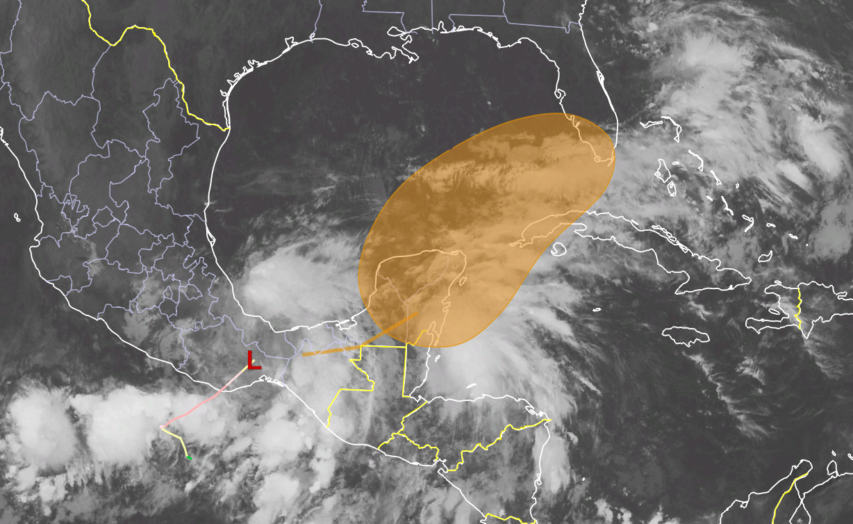
Infrared satellite image of Tropical Depression Agatha centered over the Isthmus of Tehuantepec.  The past track is shown by the colored line, and the latest region of potential development within the next 5 days as highlighted by NHC is indicated by the orange shading. 

These "crossover" storms (Pacific to Atlantic or vice versa) occur now and then; it's certainly not unprecedented.  Last year, Grace (Atlantic) crossed into the Pacific and became Marty.  Similarly for Nana -> Julio in 2020... and the last time a storm went from the Pacific and redeveloped in the Atlantic was Amanda -> Cristobal in 2020.

Even if this system ends up not taking the first name, 2022 can already claim the latest first named storm formation since 2014!

As far as model guidance goes, the European model has consistently been more aggressive than the American model in re-developing it and bringing higher rainfall totals to Florida.  This doesn't necessarily mean it will be right, but it has been the most consistent for several days now.  Other models keep it more diffuse and complicated, actually extending the period over which heavy rain is possible.  The map below shows the probability of a tropical cyclone strike (at least a tropical depression) in the coming five days from the European model ensemble.


Regardless of development, a swath of heavy rain is likely across west Cuba and then south Florida in the coming days.  The low pressure or tropical cyclone could reach south Florida as early as Friday, or as late as Sunday, with the highest likelihood on Saturday.  Models are indicating the potential for extremely heavy rainfall in south Florida, perhaps in the 6-12 inch range. The graphic below is the latest 7-day rainfall forecast from the NOAA Weather Prediction Center (Tuesday morning through Tuesday morning).  That little light-yellow blotch over the south tip of the peninsula is the 10-15-inch category.


The Atlantic hurricane season officially begins tomorrow.


25 May 2022

Hurricane season officially begins in one week, but will it start early AGAIN?

The official Atlantic hurricane seasons spans June 1 through November 30, but nature is of course not bound to those arbitrary dates.  In fact, there have been "pre-season" named storms every year since 2015 -- this would be the eighth consecutive year if it should occur!
So, what are the chances of something developing before June 1? Pretty slim, but it could be close.  Models have been persistently showing the possibility of development in the southern Gulf of Mexico in 7-10 days.  In this latest European model ensemble plot (below), the probability of a tropical cyclone existing before June 1 is shown on the top and before June 3 on the bottom.  From this, the chances appear to be minimal before the official start of the season, but then jump up in the days that follow.  And this is for any tropical cyclone -- if we raise the bar to tropical storm intensity (a named storm), the peak values in the Gulf are in the 10-20% range.  


In short, this is nothing to be concerned about, but something to at least keep an eye on as we head into the first week of the season, and especially if you're in any of the areas surrounding the Gulf of Mexico.

The seasonal forecasts of overall activity indicate that yet another above-average season is likely.  There are a few large-scale environmental signals that go into that outlook, but a notable player is the persistent La Niña.  La Niña is defined to exist when the water temperatures in the equatorial eastern Pacific Ocean are significantly cooler than average, and one of the teleconnections that has is to reduce the vertical wind shear across the tropical Atlantic, making hurricanes more likely to develop and intensify (all other things being equal).

But what makes this expectation of another active season remarkable is that it would be the seventh consecutive above-average season!  If we look at ACE (Accumulated Cyclone Energy), the past six seasons all had values of 132+.  The average over the past fifty years is 104.  But, never in recorded history were there more than three consecutive seasons with 130+ ACE, let alone six or seven.  This is an unprecedented prolonged span of elevated activity.


The name list this season begins with Alex, Bonnie, and Colin, and new names on it are Martin and Owen.  There are six lists of names that are used cyclically, unless a name gets retired due to a particularly devastating impact somewhere.

This list first appeared in 1980, and 9 of the 21 original names have been replaced at some point in the past 42 years.  This table shows the evolution of the list, with retired storm names in red bold font, replacement names in blue italics, and the single occurrence of a retired replacement name (Igor in 2010) in purple bold italics. Unused names that season are indicated by gray font.  Time well tell how far down the list 2022 will go!


Finally, if you missed my post in early April on the Cone of Uncertainty Update and Refresher, please check that out too.