24 September 2018

Storms fester in the Atlantic — including remnants of Hurricane Florence

This past weekend saw a flurry of activity across the Atlantic, but most of it is already gone!  My summary and outlook for the coming week are available on the Capital Weather Gang blog:

Storms fester in the Atlantic — including remnants of Hurricane Florence


16 September 2018

'Florence the Terrible' rewrites North Carolina's history books

As of Sunday morning, Tropical Depression Florence is located just 230 miles from where it was on Friday morning when it made landfall... that's an average speed of 4.8 mph.  This slowing to a drift right near the coastline was well-predicted several days prior to landfall, so while it's a success for the weather models, it's a disaster for the affected areas.

Estimated three-day rainfall totals, from Thursday morning through Sunday morning.
At 5am Eastern on Sunday, Florence was centered near Columbia SC and had peak winds of 25 mph.  Of course, it's not the winds that were or are the concern, it's the RAIN. "Florence the Terrible" has smashed the record for North Carolina's wettest tropical cyclone... Floyd (1999) held the record at 24.06 inches, but Florence's maximum so far (it's still adding up) is at 30.59 inches as of Saturday night.  Large swaths of eastern NC have received over 20 inches since Thursday morning.

And this is not over yet.  The outlook for the next three days includes even more rain focused on North Carolina.  And even after the rain departs, the rivers will keep rising as they feed into each other and accumulate. (If you are near a river in the affected areas, check https://water.weather.gov/ahps/ for forecast flood stages... the crest could still be several days away).

Three-day rainfall forecast, valid from Sunday morning through Wednesday morning.
It's worth repeating again today that "there's more to the story than the category".  What does that mean exactly? The category rating we hear about refers only to the peak wind in the storm -- it says absolutely nothing about the size of the storm, the storm surge potential, or the rainfall potential. So while you may still have a roof on your house because "it's only a Category 1", you may also be desperately hoping to get rescued from that same roof because of the flooding.

Tornadoes are always a threat in rainbands, and so far there have been two tornado reports in southeast NC, with the threat still active today. Tornadoes embedded in rainbands are typically on the weak end of the scale, but move extremely fast and with little to no warning. Plus, with saturated ground, it doesn't take much wind to topple trees.

Locations of the two tornado reports as of 6am Sunday (left) and tornado risk for the rest of Sunday (right).
This long regional radar loop starts on Wednesday night and runs through Sunday morning... it gives an idea of how slow the motion has been, and how the warm ocean provides an endless fuel source to keep intense rainbands energized that can dump rain at a rate of 2-3 inches/hour for hours at a time over a given location.  The latest version is available at http://andrew.rsmas.miami.edu/bmcnoldy/tropics/radar/


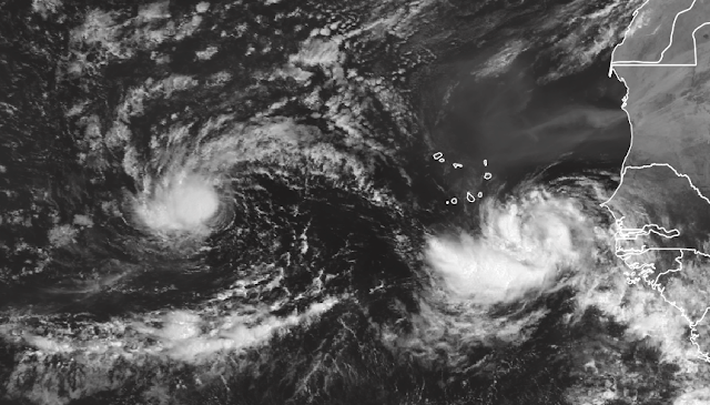
Elsewhere, Helene and Joyce will both be "terminated" today as they become extratropical cyclones, and advisories were ended for Isaac on Saturday morning, though the remnants are being monitored for potential redevelopment.

(EUMETSAT)


14 September 2018

Florence makes landfall but life-threatening storm surge and rainfall lingers


Radar image from the time of landfall.
Florence made landfall around Wrightsville Beach NC at 8am on Friday as a Category 1 hurricane. As expected and feared, the flooding from both storm surge and rainfall has been terrible and will continue throughout the weekend. Widespread catastrophic wind damage is the only aspect of the storm that was avoided because of its pre-landfall weakening.

Satellite image from the time of landfall.
PRELIMINARY TOTALS: From Thursday morning through Friday morning, Morehead City up near Cape Lookout has received 30" of rain, and down by Cape Fear, Wilmington is at 17" so far and Wrightsville Beach is at 18.5".  Unfortunately, there's lots more to come. Additionally, the storm surge up in the New Bern area has been reported at 10-15 feet, just to give an idea of the severity of this.

24-hour rainfall totals, spanning Thursday morning through Friday morning (https://nc.water.usgs.gov/realtime/rainfall.php)
The storm surge and rainfall will continue today and into tomorrow.  Coastal areas will experience multiple peaks in the storm tide (that's the total observed water level which is a combination of the astronomical tide and the storm surge) because the strong onshore winds will persist through several high tides. Florence is just drifting to the west at 6 mph -- at that rate, it will move less than 100 miles by tonight.

Storm surge warnings still cover a lot of the NC coast and the northern SC coast. Inland flooding due to excessive rainfall is likely from today through the weekend.
After a slow, drawn-out landfall from southern NC to northern NC, Florence will eventually start pulling out of the Carolinas by Monday morning.  The storm surge will have ended by then, but not the flash flooding. Beyond that, it should turn toward the northeast and dissipate... but still bring gusty winds and heavy rain to the northeast on Monday and Tuesday.


A key phrase and message that needs to be repeated over and and over is "there's more to the story than the category!".  The category rating of a hurricane only refers to the peak sustained winds in the eyewall, so it does not account for the storm's size or the tremendous impacts from storm surge and rainfall.  There are many examples of Category 1 and 2 hurricanes being far more destructive, deadly, and costly than the rarer, stronger "major hurricanes" (Category 3+).

These non-wind-related risks have been emphasized for many days... pulling from some of my posts over the past 8 days:

Sept 6: "an inland track would bring multiple hazards, including torrential rain and damaging winds over coastal and some inland areas, and a substantial rise in water above normally dry land in coastal zones. A storm hugging the coast offshore would result in heavy rain and strong winds near the coast, dangerous surf, beach erosion and coastal flooding" 

Sept 7: "coastal areas will deal with a damaging wind threat, flooding rain and a substantial storm surge — which is a rise in ocean water above normally dry land. Some areas further inland could also contend with damaging winds and flooding rain."

Sept 8: "impacts such as rainfall and storm surge will blanket a large portion of the coastline regardless of if and where it makes a direct landfall."

Sept 9: "threat in the Carolinas and Virginia: a life-threatening storm surge at the coast [and] life-threatening freshwater flooding from a prolonged and exceptionally heavy rainfall event” from the coast to interior sections."

Sept 10: "storm surge and coastal flooding will almost certainly be a big problem from North Carolina up into the Long Island area. ... models suggest ... a stalled tropical cyclone producing incredible and dangerous amounts of rain over the mid-Atlantic region."

Sept 11: "This could be an unprecedented disaster for North Carolina ... enormous rainfall totals could be in store for coastal areas as well as inland ... Storm surge is a very big concern ... large swells, elevated water levels, and coastal flooding will affect Florida through Massachusetts over the coming days"

Sept 12: "Florence is still expected to reach the coast early Friday morning as a major hurricane, but could actually drift southward along the coast, delivering a destructive storm surge to hundreds of miles of coastline, as well as feet of rainfall at the coast and inland."

Sept 13: "The storm has grown in size over time as they typically do, so although the peak winds are weaker than they were, the storm surge threat has actually increased for more of the coastline. Rainfall has been and continues to be a significant danger.  A tropical cyclone of any intensity can dump feet of rain if it moves slowly, and Florence is no different. 20-40 inches of rain could fall over parts of eastern North Carolina which would easily induce tremendous flash flooding. Even further west into the mountains, 6-10 inches of rain could fall. The rain will persist for a few days in this region."

The public must get beyond the "it's only a Category 1" mentality.  Wind is one of the three primary hazards associated with tropical cyclones, and in the US, it's by far the least deadly and costly.

The rest of the tropics can be summarized in a single map... Helene is quickly losing its tropical characteristics over the cold eastern Atlantic but could bring stormy conditions to the Azores, Isaac has entered the eastern Caribbean and weakened to a tropical depression, and Joyce is a tropical storm that will orbit around and get obliterated by Helene in the near future.  This surge in activity will come to an abrupt end this weekend.


13 September 2018

Florence's wind and rain reaching eastern North Carolina; also watching Helene, Isaac, Joyce


It's been two weeks since Florence formed, and early Thursday morning, the first rainbands and tropical storm force winds from this long-track hurricane have reached Cape Hatteras and Cape Lookout (lots of radar loops).  At 8am, the storm was centered 170 miles east-southeast of Wilmington NC and moving toward the northwest at 12 mph.  Maximum winds in the eyewall fell to 110 mph, making it an upper-end Category 2 hurricane.  It is not expected to strengthen anymore, even as it passes over the warm Gulf Stream today.


However, THERE'S MORE TO THE STORY THAN THE CATEGORY. While the peak winds have fallen, they are still strong enough to be destructive to houses and trees, and the water-related threats (storm surge and rain) remain a very big concern.  Tropical storm force winds extend up to 200 miles from the center.

The storm has grown in size over time as they typically do, so although the peak winds are weaker than they were, the storm surge threat has actually increased for more of the coastline. The storm surge warning from Cape Fear to Cape Lookout still includes a potential for 9-13 feet of storm surge, on top of the normal tides (flooding will be worse around high tide, and a slow-moving storm will stick around for at least one tide cycle). Now that the landfall trajectory is fairly locked in, here are some storm surge inundation maps for the Cape Lookout and Cape Fear areas, but I encourage you to peruse it in more detail at https://www.nhc.noaa.gov/refresh/graphics_at1+shtml/093018.shtml?inundation#contents
You can also monitor relevant tide gauges at https://tidesandcurrents.noaa.gov/quicklook/view.html?name=Florence


Rainfall has been and continues to be a significant danger.  A tropical cyclone of any intensity can dump feet of rain if it moves slowly, and Florence is no different. 20-40 inches of rain could fall over parts of eastern North Carolina which would easily induce tremendous flash flooding. Even further west into the mountains, 6-10 inches of rain could fall. The rain will persist for a few days in this region.  The latest forecast does not indicate quite as much of a prolonged stall, but rather a gradual drift westward then turning northward out of the Carolinas by Monday.


Only 29 hurricanes have made landfall within 100 miles of Wilmington since 1851... the most recent was Arthur in 2014, and the most intense was Hazel in 1954.  Florence will become the 30th tonight.


A brief overview of the rest of the tropics, which are bursting with activity.  Hurricane Helene is quickly disintegrating as it heads north over cool water, Tropical Storm Isaac remains disorganized as it passes over the Leeward islands, Subtropical Storm Joyce is spinning innocently well west of the Azores, and that pesky disturbance in the Gulf of Mexico is still a rainfall threat for Texas this weekend.

Since Joyce formed yesterday, the season is up to 10 named storms, 5 hurricanes, and 1 major hurricane.  In an average season by this date, we'd have 7 named storms, 3 hurricanes, and 1 major hurricane. In terms of ACE (Accumulated Cyclone Energy), the season is at 127% of average for the date.


12 September 2018

Florence will likely impact the Carolinas from Thursday morning through Monday


We are another day closer to Florence's landfall, and the trends in model guidance are actually even worse for more people. As of Wednesday morning, Florence is still a Category 4 hurricane and very little stands in its way to weaken it. It is centered 540 miles southeast of Wilmington NC and moving quickly to the west-northwest at 17 mph.

For 2-3 days, models have been hinting at a dramatic slowdown as the storm approaches the coast, perhaps stalling for days, or meandering. The bad news is that trend is solidifying. Florence is still expected to reach the coast (central NC to central SC) early Friday morning as a major hurricane, but could actually drift southward along the coast, delivering a destructive storm surge to hundreds of miles of coastline, as well as feet of rainfall at the coast and inland.


Taking a look at the most recent model guidance, we can see how this stall and southward drift is looking more certain.  It's extremely important to note that this is not a dramatic shift in NHC's "cone of uncertainty".  The entire South Carolina coast has been within the 66% probability cone since Saturday morning (with the exception of a brief window from Monday morning through early Tuesday morning when the southern part of SC wasn't in it)... but now the Georgia coast is also inside the cone while the NC Outer Banks is not. Note that hurricane warnings still extend up to Virginia -- the cone does not imply anything about impacts, which will be extensive.


In terms of storm surge and rainfall, a drifting track like this would be worse than a direct hit and inland push. Elevated water levels and coastal flooding are ALREADY being observed along the mid-Atlantic coast up to Virginia and it will only get worse. As of Wednesday morning, the track and intensity forecast supports a 9-13-foot storm surge between Cape Fear and Cape Lookout. Although the peak storm surge is extremely sensitive to the exact track, several feet of storm surge will impact the coastline for hundreds of miles away from the center.


Elsewhere in the Atlantic, Helene has turned northward is and is weakening over cooler water... now a Category 1 hurricane. Isaac is still a tropical storm and it appears that it may not ever regain hurricane status, which is great news for the Leeward Islands. It's expected to cross the Leewards on Thursday as a weakening tropical storm.


There is still some interest in the disturbance heading into the Gulf of Mexico from the western Caribbean. It's poorly organized and messy now, but could develop slightly this weekend as it heads for Texas. At this point, there does not seem to be any reason for concern, but it will bring gusty winds and heavy rain there regardless of development. If named, it would be Tropical Storm Joyce.


11 September 2018

Florence closing in on Carolinas; watching Helene, Isaac, and Gulf of Mexico


Florence regained Category 4 hurricane status on Monday afternoon, and is not forecast to weaken much if at all prior to landfall.  This could be an unprecedented disaster for North Carolina. Hurricane and storm surge watches now blanket much of the South Carolina and North Carolina coasts, and enormous rainfall totals could be in store for coastal areas as well as inland. Check the NHC website for the most recent watches, warnings, and forecasts.


As of 8am EDT on Tuesday, Florence is centered 940 miles southeast of Wilmington NC and is moving toward the west-northwest at 15 mph.  It is expected to turn slightly more to the north and pick up speed in the coming days, reaching the coast late Thursday night.  Impacts such as storm surge, rainfall, and strong wind will start to arrive at least a day before the eye does, so preparations and evacuations should be complete by Wednesday night.  The current maximum sustained winds are 130 mph and are expected to increase. It could become a Category 5 hurricane (155mph+) at some point, though not necessarily maintain that through landfall.


[Technical note: Overnight, Florence underwent what's called an "eyewall replacement cycle".  ERCs are normal periodic restructuring events that major hurricanes go through. The original eyewall contracts, a new larger eyewall forms outside of it, the inner eyewall dissipates, and the new eyewall takes over.  While this is happening and shortly after, the storm tends to weaken slightly and look more ragged on satellite images, but the end result is almost always a stronger storm with a broader wind field.  We will see more of these take place in the coming days.]

Storm surge is a very big concern with intense hurricanes, and Florence will be no different.  Storm surge is extremely sensitive to the track, so this far out, it's not worth trying to pinpoint where and how much the maximum will be. But large swells, elevated water levels, and coastal flooding will affect Florida through Massachusetts over the coming days (i.e. a BIG portion of the east coast).

Models are still in disagreement on the stall. Some have Florence making landfall and moving inland like "normal", while others paint a scenario where shortly after landfall, the dominant steering features in the atmosphere leave the storm without anywhere to go, so it sits for days in the same place. That would certainly be the worse of the two options. The image below shows the 7-day rainfall forecast on the left and the 3-day flash flood potential on the right.


Hurricane Helene is nearly a major hurricane now, which would be the second of the season.  It is located west of the Cabo Verde islands and is forecast to turn northward into the open Atlantic. There's a chance it could reach the Azores over the weekend, bringing rain and gusty winds even it's not technically a tropical cyclone by then.


Isaac has been battling dry air and losing, and has been downgraded to a strong tropical storm.  But, it is forecast to at least maintain that intensity and impact the Lesser Antilles in a couple days.  Tropical storm force winds should reach the Leeward islands by Wednesday night, and the storm could cross the islands on Thursday night possibly as a Category 1 hurricane (coincidentally, the same timing as Florence and the Carolinas). I'd guess that hurricane watches will be issued later this morning. There is significant disagreement in the models regarding what happens to Isaac beyond Friday, so there's almost no point in even discussing it yet.


Finally, the disturbance in the western Caribbean remains disorganized and heavily sheared. Models do not favor development into a tropical cyclone, but as it oozes toward the northwest, the chances for heavy rain in Texas still exist through the end of the weekend.


10 September 2018

Three hurricanes and two areas of interest pepper the Atlantic

This week is the climatological peak of hurricane season, and it's certainly living up to that expectation. There are three active hurricanes: Florence, Helene, and Isaac, as well as two areas of concern for future development.


The last time we saw three simultaneous hurricanes was in 2017, and there were actually *four* simultaneous hurricanes in 1998.  So this is active, but far from unprecedented.  Now on to business...

For the first time since Thursday, Florence is a major hurricane (Category 3+) with 115 mph sustained winds.  The appearance on satellite is spectacular, indicating that it is now in an ideal environment for rapid intensification.  This was expected, but certainly not good news for the southeast and mid-Atlantic U.S. coast.  The atmosphere and ocean ahead of it can easily support a Category 4 or 5 hurricane.  This is an extremely dangerous situation for the Carolinas.


In fact, this is shaping up to be a historic event.  The official forecast from NHC has Florence making landfall between Charleston SC and Norfolk VA with 66% probability (the definition of the cone of uncertainty) as an upper-end Category 4 hurricane.  Tropical storm force winds should arrive as early as Wednesday evening, while storm surge and rainfall will be joining the winds between Wednesday afternoon and Thursday morning.  It's too early to have a sense of maximum storm surge placement since it is so sensitive to the track. However, storm surge and coastal flooding will almost certainly be a big problem from North Carolina up into the Long Island area, including the Delmarva peninsula and New Jersey through the weekend.


Since 1851, the continental U.S. has only experienced 29 direct landfalls from Category 4 and 5 hurricanes, and the northernmost was on the SC/NC border (Hazel in 1954). See https://twitter.com/BMcNoldy/status/1038903174172688389 for a map. North Carolina has never experienced a Category 4 or 5 hurricane landfall, and only three Category 3 landfalls on record.  Events such as this are infrequent -- testing people, structures, vegetation, resources, and plans.

Ensemble guidance from the U.S. and European models still have some spread, ranging from a landfall in northern Florida to recurving just before reaching the coast. Unfortunately, this is how predicting the future works... best expressed as probabilities rather than certainties. As the saying goes: prepare for the worst and hope for the best.


Another aspect of the forecast is what happens to Florence after landfall?  Does it keep moving inland and dissipate while spreading rain over a larger area, or does it stall for several days and unleash rain measured in feet. As of now, most models suggest the latter... a stalled tropical cyclone producing incredible and dangerous amounts of rain over the mid-Atlantic region.

Seven-day rainfall forecast, valid from Monday morning through next Monday morning... and it could still be raining beyond this in the same areas. (NOAA/WPC)
Further east, Helene became the season's 4th hurricane on Sunday afternoon, and Isaac became the season's 5th hurricane on Sunday night. Climatologically, the 5th hurricane forms on October 6th, so this is ahead of par.

It appears very likely that Helene will maintain hurricane status for another three days or so, but make a sharp turn to the north over cold water and dissipate quickly in the middle of the Atlantic.

Isaac is a growing concern for the storm-ravaged Lesser Antilles.  Although its a bit disorganized now, the forecast is for it to continue westward as a hurricane, reaching the islands on Thursday. It does not appear that it will be too strong though, as wind shear should start affecting it by Wednesday.  Nothing like Maria last September.


In terms of ACE (Accumulated Cyclone Energy), the season was above average up until August 21 when it finally slipped below average.  As of this morning, it is at 89% of average for the date. Remember that it takes a lot of action this time of year to keep up with climatology!  Unfortunately, some of that action can occur near land.


The other two areas of interest are located in the western Caribbean and over the north-central Atlantic. The disturbance in the western Caribbean is expected to drift through the Gulf of Mexico from Wednesday through Friday, eventually bringing rain to Texas... but models generally do not indicate significant strengthening -- maybe a tropical storm. The north-central Atlantic system is a non-tropical low that could gradually acquire subtropical or even tropical characteristics, but also does not appear to be anything to watch too closely (it could actually interact with and get absorbed by Helene!).

09 September 2018

Outlook becoming dire for southeast U.S. coast as Hurricane Florence closes in

Sunday's update on Hurricane Florence, Tropical Storm Helene, and Tropical Storm Isaac primarily looks at Florence and the associated threats arriving later this week for the U.S. east coast.  It is available on the Washington Post's Capital Weather Gang blog:

Florence strengthens to hurricane and poses extreme threat to Southeast and Mid-Atlantic


08 September 2018

Peak week of hurricane season features Florence, Helene, and pre-Isaac

If it seems like there's a lot going on in the tropics now, you'd be right. Climatologically, the second week of September is the most active part of the entire six-month season, and 2018 is falling right into place.  (recall last year at this time, we were dealing with hurricanes Irma, Jose, and Katia)

Tropical Storm Florence will threaten the U.S. east coast later in the week, Tropical Storm Helene is affecting the Cabo Verde islands right now, and Tropical Depression Nine is poised to become Tropical Storm Isaac very soon, though not immediately affecting land.

Enhanced infrared satellite image of the tropical Atlantic. Florence, Tropical Depression Nine, and Helene are scattered across the basin. (tropicaltidbits.com)
First: Florence.  Florence formed nine days ago near the Cabo Verde islands, and has been watched very closely ever since then.  As the days ticked by, the threat to the U.S. east coast has grown, and a landfall is now the most likely scenario in the Thursday timeframe. As of Saturday morning, it is centered 1550 miles southeast of Wilmington NC and has peak sustained winds of 65 mph.


Although it is still just below hurricane strength, the environment is expected to favor substantial intensification in the next five days, and the official forecast from the National Hurricane Center brings a strong Category 4 Hurricane Florence ominously close to the southeast and mid-Atlantic coast by Thursday morning.  If you are in the Jacksonville to Cape Hatteras line, now is the time to begin the preliminary preparations.  As time goes on, the area of greatest concern will become more focused, but impacts such as rainfall and storm surge will blanket a large portion of the coastline regardless of if and where it makes a direct landfall.


Both the European and U.S. global models and their ensembles support this, with very few outliers missing the United States coast now.  They have been consistent (or trending) with this for several days.


For some historical perspective, I created a map showing the tracks of all major hurricanes (Category 3+) that made a direct landfall between Jacksonville and Cape Hatteras since 1851. There have been only ten: Fran 1996, Hugo 1989, Gracie 1959, Hazel 1954, and six unnamed hurricanes prior to 1900.  This would be a rare event, and plenty of residents have probably never experienced anything like it.

Tracks of the ten major hurricanes that made landfall between Jacksonville and Cape Hatteras since 1851.
Much further east, Tropical Depression 8 and 9 formed in the far eastern Atlantic on Friday afternoon.  Tropical Depression 8 has since been upgraded to Tropical Storm Helene, and Tropical Depression 9 is well on its way to becoming Tropical Storm Isaac.

The visible satellite image below shows TD9 (pre-Isaac) and Helene, and the animated map of ensemble forecasts above gives you an idea of which way each is likely to go in the coming days. Future-Isaac looks like it will remain at low latitudes, reaching the Lesser Antilles by Wednesday night, probably as a hurricane.  Helene will likely find a weakness in the subtropical ridge and slide northward into the open Atlantic this week.

Tropical Depression Nine (left) and Tropical Storm Helene (right). (EUMETSAT)
Stay tuned!


07 September 2018

Florence is predicted to restrengthen and is a hurricane threat to the East Coast

Florence is the big topic of interest, especially to the U.S. East Coast next week, but a couple other systems are picking up steam off the coast of Africa. Today's full update is available on the Capital Weather Gang blog:

Florence is predicted to restrengthen and is a hurricane threat to the East Coast


04 September 2018

Gordon to hit Gulf coast tonight, Hurricane Florence remains far from land


Tropical Storm Gordon has been picking up steam in the Gulf of Mexico since forming over the Florida Keys on Monday morning.  It is now packing 65mph sustained winds and is expected to become the season's fourth hurricane later today before it makes landfall. It is moving at 15mph toward the west-northwest -- on that trajectory, the center should cross the coastline just before midnight local time. There are a couple active radar loops to monitor Gordon at http://andrew.rsmas.miami.edu/bmcnoldy/tropics/radar/


Hurricane warnings, tropical storm warnings, and storm surge warnings plaster the north-central Gulf coast where 4-6 inches of rain is expected along its path and coastal areas in the Gulfport-Biloxi-Mobile area can expect up to a 3-5-foot storm surge (on top of the regular tides).

The previous hurricane to make landfall on the U.S. was Nate last October, and it hit exactly where Gordon will tonight.

And then there's recently-upgraded Hurricane Florence.  Recall that Florence formed on August 31, very quickly after leaving the African coast.  It became the season's third hurricane today.


Fortunately, over the past few days, a westward track that would bring it close to the U.S. by the middle of next week appears less likely. Both the ECMWF and the GFS ensembles now have very few members with tracks that maintain a U.S.-bound course. So it can't be ruled out, but it's unlikely. Bermuda should be paying close attention though.


As is typical for this time of year, Africa is alive with potent easterly waves. Global models indicate that the next two waves could become tropical cyclones this week, and the next couple of names on this year's list are Helene and Isaac.