23 June 2023

Bret and Cindy usher in a historic day for the tropical Atlantic

Named storms forming in June are not that uncommon -- in the past three decades there have been thirty of them.  But of those thirty, only two formed in the deep tropics east of the Caribbean (Bret 2017 and Bonnie 2022).
Having two simultaneous named storms in June is exceptionally rare -- it's happened just once before in 1968 (Brenda and Candy).
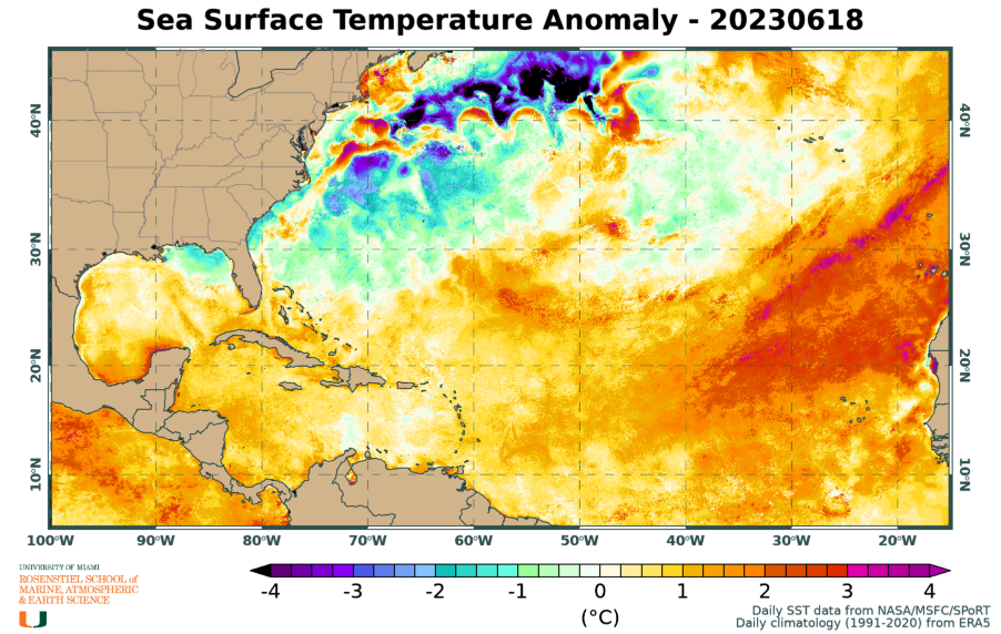
Now in 2023, not only are there two named storms during June in the Atlantic, they're active simultaneously and both formed from African easterly waves east of the Caribbean.  This unprecedented event is undoubtedly enabled by the record-breaking ocean temperatures in the eastern tropical Atlantic and the related relative dearth of dry Saharan air plumes.


Tropical Storm Bret crossed the Lesser Antilles on Thursday night as a strong tropical storm as forecast, and is now in the eastern Caribbean Sea where a much more hostile environment awaits it.  Tropical Depression Four was upgraded to Tropical Storm Cindy on Thursday night and will almost certainly miss the Lesser Antilles.

The satellite loop below shows Bret as of Friday morning, but the NHC forecast (and most model guidance) indicates that the storm will dissipate by Sunday as the wind shear picks up significantly.  The track forecast takes it due west, so impacts to land in its final days will be minimal.


Cindy, on the other hand, has several days of activity ahead of it before it reaches an area of high wind shear.  Model guidance generally keeps it below hurricane intensity, but there's a shot at it this weekend before it begins to weaken again.  The official NHC forecast as of Friday morning is shown below, and the track guidance from models is pretty tightly clustered.


Given that these two storms have limited time before wind shear overwhelms them, this will likely be my last update on them.  Elsewhere across the basin all is quiet, but the next name on this year's list is Don.  Cindy formed *40 days* before the average date of third named storm formation, so there's no doubt this season is off to a strong start.  If Cindy does manage to become the season's first hurricane this weekend, you can see just how anomalously early that would be!


22 June 2023

TS Bret and TD Four keeping the tropical Atlantic active


Tropical Storm Bret, which formed on the 19th from an easterly wave that left the African coast on the 15th is now about to cross the Lesser Antilles and enter the Caribbean Sea.  Then, newly-upgraded Tropical Depression Four is trailing just 1000 miles east of Bret.  The location of this activity is something we don't typically see "turn on" for another couple of months.

Bret is very close to hurricane intensity as it nears the Lesser Antilles... the center should pass over Martinique or St. Lucia on Thursday night, though squally weather will of course extend further away than that (primarily to the north of center).  A tropical storm warning is in effect for Dominica, Martinique, and St. Lucia, and a hurricane watch is in effect for St. Lucia.  You'll find the most current information at https://www.nhc.noaa.gov/graphics_at3.shtml?start#contents


The storm is already experiencing moderate vertical wind shear, so the low-level circulation is displaced to the west of the mid-level center and the bulk of the thunderstorm activity.  The wind shear is expected to increase as Bret enters the Caribbean, so it has likely peaked in intensity and will gradually get ripped apart this weekend.
Radar loop from Barbados, available at https://bmcnoldy.earth.miami.edu/tropics/radar/

Then, the wave behind it which left the African coast on the 18th was upgraded to Tropical Depression Four on Thursday morning.  Although it's following closely in Bret's footsteps, the steering pattern has evolved and this storm will most likely turn to the north before reaching the Lesser Antilles and eventually weaken in the face of strong wind shear early next week somewhere south of Bermuda.  It is forecast to strengthen to a tropical storm later today, and the next name is Cindy.

This map below shows track forecasts from three global model ensembles, ending Tuesday morning. The black line is the mean of all three ensembles. The intensity guidance generally keeps this below hurricane intensity.


Elsewhere, the basin is quiet for now, but this is certainly a bizarre couple of storms to be writing about so early in the season.

20 June 2023

Bret heading for Lesser Antilles, Cindy could also form this week


We are still watching two features of interest in the deep tropics between the Caribbean and Africa: Tropical Storm Bret and Invest 93L.  As strange as it would be to have just one such system in June, having two is extraordinary.  Anomalously-warm ocean temperatures and a lack of the typical Saharan dust in the eastern Atlantic have allowed the Cabo Verde season to begin about two months early.

Tropical Depression 3 was upgraded to Tropical Storm Bret on Monday afternoon and is centered about 1000 miles east of the Lesser Antilles on Tuesday afternoon.  The latest NHC forecast no longer brings Bret up to hurricane intensity, and dissipates it in the central Caribbean over the weekend.  That closely follows most of the model guidance, with the notable exception of the HWRF model which has consistently been clinging to a strong hurricane in the eastern Caribbean. 


Bret will reach the Lesser Antilles on Thursday night, most likely as a struggling tropical storm.  Wind shear is going to increase quite a bit as it enters the Caribbean, so it probably will not make it to the western Caribbean intact.  In the slim chance that HWRF has had the right solution all along, the big divergence in forecasts between that and the others happens on Thursday; if it starts showing signs of intensifying as it crosses the Lesser Antilles, there's reason for concern in Puerto Rico and surrounding islands.

Invest 93L is being given an 80% chance of formation within the next seven days (70% within the next two days)... it would be Tropical Depression 4 or Tropical Storm Cindy if it does become a tropical cyclone.  It's trailing just 900 miles east of Bret, but as of now, the track model guidance is showing a turn to the north well before it reaches the Lesser Antilles. For intensity, no models show it reaching hurricane intensity.

As I wrote yesterday, using the 1991-2020 climatology, the average dates of the second and third named storms are July 15 and August 2.  If Bret becomes a hurricane in the coming days it would really be exceptional -- the average date of first hurricane formation is August 11!


19 June 2023

Tropical Depression 3 forms in deep tropics, another potential storm on its heels

As I mentioned in Saturday's post (What month is it?), the location of this activity is extremely unusual for mid-June... it's what we would typically see in another 2-3 months.  But anomalously-warm water in the tropical east Atlantic is accelerating the Cabo Verde season.


On Monday, Invest 92L was upgraded to Tropical Depression 3, and it's fully expected to become a tropical storm soon and the season's first hurricane by Thursday... the next name on the list is Bret.

This nice super-ensemble track density map (combines four global model ensembles) from Tomer Burg shows that the vast majority of model tracks go into the Caribbean, with a few stragglers turning to the north before reaching the Lesser Antilles. It's worth noting that those few stragglers are on the stronger end of the guidance (in other words, scenarios that include quicker intensification generally are quicker to turn north).


For the most part, the intensity shown by models is on the low end as it enters the Caribbean on Friday (tropical storm, maybe Cat1 hurricane), but one notable exception is the skillful HWRF model which turns 16 years old this year.  It brings future-Bret into the central Lesser Antilles as a Category 3 hurricane on Friday morning then into Puerto Rico as a Category 4 hurricane on Saturday night.  Granted, this is just one model, but it's not just one cycle; it's been consistently showing a strong hurricane reaching the Lesser Antilles.  It's absolutely worth considering as a plausible (though not likely) scenario.

The official NHC forecast (as of Monday morning) is shown below and brings future-Bret into a Caribbean as a Category 1 hurricane, but they include an important sentence in the discussion: "This intensity forecast is also more uncertain than normal, due to the differences in the model suite, along with the aclimatological nature of this system."


Then, not far east of TD3 is another area of interest, Invest 93L.  Model guidance so far indicates it could take a similar track to what TD3 will, though perhaps a little more likely to turn to the north before reaching the Lesser Antilles.  I won't spend much time on it yet, but if it continues to develop, there will be more detail in future posts.  If it also becomes a tropical storm, the name would be Cindy.  It's just very bizarre to be seeing this in June!

Visible satellite loop over TD3 (left) and Invest 93L (right).

Using the 1991-2020 climatology, the average dates of the second and third named storms are July 15 and August 2, so just getting Bret this week would be exceptional.  Even more exceptional would be if TD3 becomes a hurricane in the coming days -- the average date of first hurricane formation is August 11!


17 June 2023

What month is it? Next storm likely to form from African wave

A tropical wave that left the African coast a couple days ago is strongly favored to become the next named storm, Bret, in the coming days.  This would not be unusual at all in August or September, but it's mid-June.  It could even become the season's first hurricane next week.


A key player in this accelerated "Cabo Verde" season is the Azores High, a quasi-permanent feature of the subtropical North Atlantic Ocean. It gets its name because it's typically centered near the Azores Islands (about 1000 miles west of Portugal)... though it does have some variability in its position and strength.  However, if we look at the average surface pressure over the past couple of weeks and compare that to its normal position and intensity, we clearly see that it is significantly weaker and displaced to the southwest.

Average sea level pressure from June 1 - June 14 during 2023 (top) and during a climatological period of 1991-2020 (bottom).  Pressure values (in millibars) are plotted on the same scale for easy comparison.

This huge difference is allowing the easterly winds that blow across Africa and across the tropical ocean to be weaker, resulting in less Saharan dust transport from the continent (those dust plumes are good at intercepting the sun's energy before it reaches the ocean) AND in reducing the evaporative cooling of the water.  The combined effect has been to create alarming and record-smashing sea surface temperature anomalies in the tropical east Atlantic.  This has turned that part of the basin from what would typically be too cool for tropical cyclone development to plenty warm for development.  We're seeing a 2-month boost to the Cabo Verde season as a result.

Daily SST anomaly relative to a 1991-2020 climatology.  The warm anomalies in the eastern tropical Atlantic are accelerating the onset of the Cabo Verde season.  The approximate location of Invest 92L on Saturday morning is circled in white.  Available at  https://bmcnoldy.earth.miami.edu/tropics/sectors/

Back to the feature of interest, which is tagged as Invest 92L.  With this unusually-favorable environment to work with, the National Hurricane Center is giving it a 40% chance of development within the next two days and a 70% chance within the next seven days. The area of potential formation within the next seven days is illustrated by the red shape on this map.  This is not a track forecast or a "cone of uncertainty", just an envelope of potential formation as the disturbance plods along.


The outlook from some of the earliest model guidance available for Invest 92L is very bullish, with two reliable hurricane models, HMON and HWRF, bringing this to nearly a Category 3-4 hurricane in a week.  Most models are not that high, but still a hurricane appears likely as it nears the Leeward Islands next weekend.  This is definitely something to watch closely. 


02 June 2023

Tropical Storm Arlene forms on Day 2 of Hurricane Season

The official Atlantic Hurricane Season spans June 1 through November 30, and coincidentally, Tropical Depression 2 formed on June 1... and was just upgraded to Tropical Storm Arlene on June 2.  Although it's located right off the Florida peninsula, there is no cause for concern.  There is zero guidance suggesting this will intensify beyond where it's at now.


As you can see in the satellite animation above, the low-level circulation (the swirling part) is almost entirely exposed and the strong thunderstorm activity (the bright white part) occupies a small portion of the area to the northeast of the center.  This is indicative of strong vertical wind shear, and that is expected to increase.  So, Arlene will not be around for long, but its moisture will be.

Arlene will track generally south toward Cuba today and Saturday, then whatever is left is forecast to head east toward south Florida.  The only likely impact is elevated chances of heavy rain on Sunday-Monday.  The map below shows the forecast rainfall accumulation through Monday evening from the GFS model -- don't take the details literally, but you get a sense of the areas that could potentially see some flooding rains.


You may recall last hurricane season also had a prompt start with Tropical Storm Alex forming on June 5.  However, for the seven years before that, the first named storms all occurred before June 1.  Over the past fifty years, the trend of the date of first named storm is decidedly getting earlier.

The next name on the list is Bret, but there's no hint of that happening anytime soon.  The 2023 list of storm names in the Atlantic is List 3 (out of 6), which was first used in 1981 and every six years since.  10 of the 21 original names are still on the list.  New names on it this time around are Harold, Idalia, Margot, and Nigel.

This list has had 12 names retired from it (Floyd '99, Lenny '99, Dennis '05, Katrina '05, Rita '05, Stan '05, Wilma '05, Irene '11, Harvey '17, Irma '17, Maria '17, Nate '17). Hopefully we don't add to that infamous list this year...