31 August 2019

Dorian now near Category 5 intensity and threatening southeast U.S. coast

Dorian intensified dramatically on Friday and Friday night, and as of Saturday at 11am EDT it has peak sustained winds of 150 mph -- making it an extremely strong Category 4 hurricane, and just 10 mph shy of Category 5 status. Recall that two days ago it was 85 mph and one day ago it was at 110 mph. There is virtually nothing in its way.


Hurricane Dorian is centered about 415 miles east of West Palm Beach FL and moving toward the west at 8 mph.  Tropical storm force winds now extend an average of 105 miles from the center. It is headed for the western Bahamas on Sunday, and then is forecast to have significant impacts along Florida's east coast on Monday-Tuesday.  Beyond that, places further north into Georgia and the Carolinas should be starting to prepare for hurricane conditions by Tuesday-Wednesday.

Over the past few model cycles, the forecast tracks have generally slowed and nudged north.  This has been a consistent trend that all models agree on. That does not preclude the opposite trend from happening this weekend (not likely, but not impossible), and all of the Florida peninsula should still be prepared for at least tropical storm force winds on Sunday-Monday.  For now, the threat to south Florida has decreased, though it should be noted that south Florida was never even under a tropical storm watch and was always on the far southern periphery of the model guidance.

The map below shows the latest rainfall guidance over the coming week.  This is not welcome news to eastern SC and NC where Florence dumped record-breaking rainfall last September.


With this shift in model guidance, many more people are in harm's way.  A major hurricane tracking along the southeast coastline is a big problem.  And even if the center never technically crosses the coastline and makes landfall, strong winds will affect land, and storm surge will impact every coastal city along the way.  A direct major hurricane landfall in South Carolina (think Hugo 1989) or North Carolina (think Floyd 1999) would be catastrophic.

The map below shows the 50-member European model ensemble forecast tracks through the next 7 days:


The history of major hurricanes passing within 150 miles of Dorian's current position includes several "recurvers", but also some infamous names like Floyd '99, Andrew '92, Hugo '89, Gloria '85, and Betsy '65 that have all been retired.

Tracks of historic hurricanes that were all at least Category 3 intensity and within 150 miles of Dorian's location.
Elsewhere, the two waves near/over Africa are still favored by models to eventually develop, and the western one that's near Cabo Verde has a 60% chance of becoming at least a tropical depression in the next five days.  Most long-range model forecasts start recurving this to the north by the time it reaches 50W or so, but I'll continue to watch it closely. The next name on the list is Fernand.


30 August 2019

Dorian nearing Category 3 intensity and still has Florida in its sight

Hurricane Dorian is strengthening, and should become the season's first major hurricane later today as it tracks north of the Bahamas. As of 8am EDT, peak sustained winds are up to 110 mph and it is centered 520 miles east of Andros Island (Bahamas) and 660 miles east-southeast of West Palm Beach (Florida).


In terms of impacts, clearly the wind will be a catastrophic impact wherever a Category 3+ eyewall lands, but dangerous tropical storm force winds cover hundreds of miles and even that is unsafe to be outside in due to trees breaking and downed power lines.  As of Friday morning, the tropical storm force winds extend an average of 75 miles from the center, and hurricane wind fields tend to expand with time.


Additionally, storm surge will be a problem over a span of hundreds of miles, but especially near the northern eyewall with the onshore winds. Storm surge guidance along with watches and warnings will start coming in this weekend. There are also exceptionally high tides this weekend due to a new moon, so flooding will be exacerbated.  And speaking of flooding, a big swath of heavy rain is expected in association with Dorian -- adding to an already drenched month across a good chunk of Florida.


Uncertainty remains in where and when landfall will be. Model guidance has trended to slow the storm down as it approaches Florida, and as such, may not even reach the coast until Tuesday.  A slower storm just allows for more time over the warm ocean and more coastal impacts over numerous high tide cycles. The ensemble guidance has come into somewhat better agreement; although quite a bit of spread exists, the two major ensembles are presently clustered between Fort Lauderdale and Vero Beach.


Beyond the immediate threats in the Bahamas and Florida, Dorian does not just suddenly disappear unfortunately... there is a decent chance that it will recurve and track up the U.S. east coast next week/weekend, so anyone up there should also be paying very close attention and think about preparedness.

Assuming Dorian hits Florida, it will be the 4th hurricane landfall in that state in as many years (Hermine '16, Irma '17, Michael '18, Dorian '19), and if it hits at Category 3 status or higher, it will be the third consecutive year with a major hurricane landfall in the state (Irma, Michael, Dorian).  While that is a fairly active period, it doesn't break any records -- there have been more active periods in Florida's extensive hurricane history, such as 1944-1950 with 11 hurricanes and 2004-2005 with 7 hurricanes.

Finally, we can't neglect to keep our eyes on the rest of the basin as the peak of hurricane season approaches.  There is a strong tropical wave just leaving the African coast today and one that is about five days behind it.  Models generally develop both of them, and NHC is giving the western one a 30% chance of development within the next five days. The next two names on this year's list are Fernand and Gabrielle.


29 August 2019

Hurricane Dorian expected to intensify as it heads toward Florida

On Wednesday, Dorian did end up tracking far enough east of Puerto Rico that the storm's circulation was not affected at all... in fact, it strengthened into the season's second hurricane right as it passed by the island.  As of 8am EDT on Thursday, it is a Category 1 hurricane with 85 mph sustained winds and is centered 150 miles north of Puerto Rico, and 1000 miles southeast of Cape Canaveral FL.  Tropical storm force winds only extend an average of 60 miles from the center, but storms typically gradually expand with time.


All environmental indicators suggest that Dorian will strengthen substantially in the next few days before reaching land. While there's a small probability that the storm turns north before reaching the southeast U.S. coast, by far the most probable outcome is a landfall along the Florida peninsula. The European (ECMWF) and American (GFS) models and their ensembles continue to indicate a spread spanning all of Florida and up into the Carolinas and some are even offshore.  In other words: be prepared.  The most probable area as of now is central Florida though.

Track density from the ECMWF ensemble (left) and the GFS ensemble (right). In both maps, the individual ensemble members are the thin gray lines and the NHC forecast is the thick black line.  On the left, the ensemble mean is not shown but the deterministic forecast is the red line.  On the right, the ensemble mean is the red line, and the deterministic forecast is the green line.  Graphics courtesy of Brian Tang at UAlbany. 
Regarding wind impacts, the timing of the onset of tropical storm force winds is what's important, because all outdoor work and preparation should be completed by then. As of now, that could be as early as Saturday evening along the east coast of Florida.  Landfall, which is when the center crosses a coastline, would most likely be Monday morning, but the timing has uncertainty too.  It could be at least a Category 3 hurricane when it makes landfall.  The irony of a Florida Labor Day Hurricane is not lost on us (for anyone who doesn't know, the Labor Day Hurricane of 1935 is still the most intense landfalling hurricane not just in Florida, but in the entire US).


Based on this, we could start seeing tropical storm and hurricane watches be issued for Florida tonight or Friday morning.  You should always consult the NHC website for the most current information.

Suppose Dorian is tracking due west when it hits the Florida peninsula. Not only is there the first impact along the east coast, but shortly after, the west coast of Florida will also get a hurricane, complete with rain, wind, and storm surge.  The Florida peninsula is flat and narrow and is barely an obstacle for hurricanes.  Then, you have a hurricane in the Gulf of Mexico which will inevitably hit somewhere else.

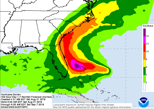
A hurricane hazard to never overlook is rain... and Dorian is no exception. Although this depends a bit on the exact track, heavy flooding rain occurs for hundreds of miles away from the storm center. This map shows the forecast rainfalls over the coming week.


28 August 2019

Strengthening Dorian passing east of Puerto Rico today, Erin forms west of Bermuda

Tropical Storm Dorian remains the primary feature of interest in the Atlantic. It is strengthening in the northeast Caribbean and will pass close to Puerto Rico today as a borderline hurricane. As of 11am EDT, the sustained winds are up to 70 mph and it's centered over St. Croix.


On Tuesday, the storm took an unanticipated turn to the north, which not only threw off the model runs, but changed the bigger picture for the worse. Even today, the storm is tracking more north than most forecasts. In fact, it won't even hit Puerto Rico head-on but rather pass to its east, which means it will not get significantly weakened by mountainous Hispaniola OR Puerto Rico, and it dramatically increases the odds of a hurricane landfall in the southeast U.S.

The map below shows the full history of NHC track forecasts for Dorian, and if you look in the eastern Caribbean, the observed track in black has been consistently north of forecasts.  That also is reflected in the longer-range forecasts, which show a steady northward trend in Florida.


The environment ahead of Dorian is favorable for intensification, so with obstacles out of its way, it is poised to become the season's second hurricane.  In fact, model guidance has recently been quite aggressive with intensification in the coming 2-4 days, and a major hurricane (Category 3+) is not at all out of the question.  The NHC official forecast brings Dorian up to Category 3 intensity in four days, but that will evolve. Based on the current forecast, tropical storm conditions could reach Florida as early as Saturday afternoon. Anyone from south Florida up into North Carolina should take this threat seriously and stay aware of changes in the forecast.


There are a couple subtle features that will be responsible for steering Dorian in the coming days: a ridge near Bermuda (the stronger that is, the more westward the track will go) and a trough moving through the midwest and eastern US (the stronger that is, the more northward the track will go).  The balancing act between them is what governs a south Florida landfall, a north Florida landfall, or even a Carolinas landfall.  The difference between those scenarios is not at much as it sounds like -- because of the curvature of the coast. Never focus on a specific model or a specific run; there can be quite a bit of variability.

A suite of dynamical global and regional models (colored lines) and the NHC forecast (black line).
As always, rainfall will be a big deal when it comes to a tropical cyclone of any intensity. Hefty accumulations are possible over all of Florida in the coming days.


It has now been a week since we started watching a disturbance over the Bahamas that passed over south Florida last weekend, then became Tropical Depression 6 on Monday, and was upgraded again to Tropical Storm Erin on Tuesday night.  It has since been downgraded to a depression again. Erin is the season's 5th named storm.  It is a highly-sheared tropical depression centered about 430 miles west of Bermuda and is forecast to track off to the northeast toward Nova Scotia on Thursday.


27 August 2019

Dorian forecast to strengthen, but big question mark lurks beyond Thursday


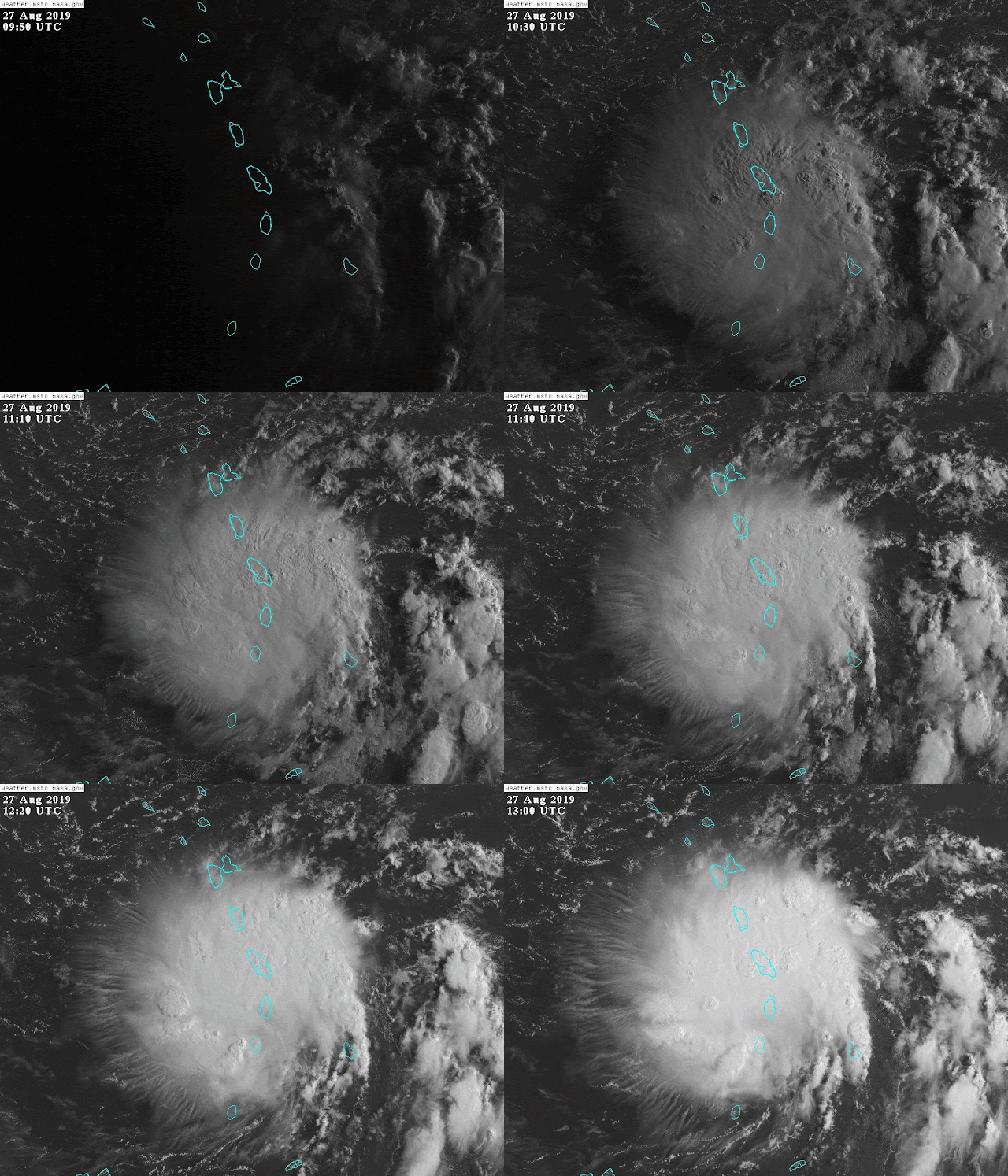
Dorian has weakened a little since yesterday, and is crossing into the eastern Caribbean as of Tuesday morning.  At 8am EDT, it's a tropical storm with 50 mph sustained winds, and its tropical storm force winds only extend an average of 32 miles from the center -- it's tiny.  It's in range of a radar in Martinique, and that confirms a ragged structure but recently getting better organized:


However, the satellite presentation is beginning to tell another story.  In the satellite loop at the top of the post, that presentation is referred to as a "Central Dense Overcast", or CDO.  It features a dome of whispy cirrus outflow clouds neatly radiating away from the center, and a couple curved rainbands forming, but still no open eye. It can be a precursor to intensification and formation of an eye, so let's watch for that today.  It still has a LOT of dry air surrounding it to contend with though.

The latest official forecast from NHC no longer brings Dorian up to hurricane intensity within the next five days, but it's important to understand that not only are there error bars around intensity forecasts (just like there's a cone around track forecasts), the upcoming encounter with Puerto Rico and Hispaniola introduces an enormous amount of uncertainty. Will it dissipate or rebound on Thursday?  I wish I knew!
And while you're thinking about the "cone of uncertainty" graphic, don't forget to check out my previous post about the cone -- it often gets misinterpreted.


Based on the NHC track and intensity forecast (and historic error distributions of both), this product shown below is the probability of tropical storm force winds within the next five days (shaded) and the most likely arrival time of those winds (lines). This threshold is important because all outdoor preparations should be completed by the time tropical storm force winds begin.


The same global model ensembles that I included in yesterday's update are included again here for reference. They have trended a bit stronger, and bit more into the Gulf rather than up the US east coast. We'll see how the next cycle looks... it's important to never take individual models or runs literally.


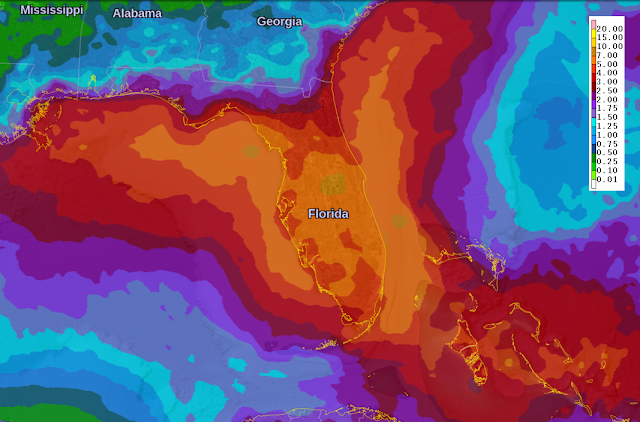
Regardless of what Dorian does in terms of intensity, it's very likely to at least provide a very wet weekend across Florida.  The map below shows forecast seven-day rainfall totals; the bulk of that comes on Friday through Sunday.


Elsewhere, that pesky disturbance that was over south Florida last weekend (Invest 98L) was finally upgraded to Tropical Depression 6 on Monday afternoon. It's presently centered about 400 miles west of Bermuda, and will zip up toward Nova Scotia and Newfoundland on Friday into Saturday.  If it does strengthen just a little more, it would be Tropical Storm Erin (or Subtropical).


26 August 2019

Dorian will enter the Caribbean on Tuesday with a very uncertain future

Since my previous update on Friday, the disturbance in the deep tropics was upgraded to Tropical Depression 5 on Saturday morning, then to Tropical Storm Dorian on Saturday afternoon.  Dorian is the 4th named storm of the Atlantic season.


The wave that would become Dorian left the African coast a week ago today and has been a feature of interest since then. This is the time of year when most of the named storms have an African pedigree.

As I mentioned on Friday, this storm has not had the most ideal of environmental conditions to deal with, so it has been slow to develop. As of 8am EDT on Monday, it's a tropical storm with 60 mph sustained winds and is centered about 300 miles east of the Windward Islands in the Lesser Antilles.  The latest forecast from NHC indicates that it could reach hurricane intensity later this week in the  central Caribbean. However, model guidance is very split on its future beyond Thursday.


This also seems like a good time to bring back the Cone of Uncertainty Update & Refresher... many people misinterpret what the cone shown above is intended to tell them and what's it's NOT intended to tell them!  The key messages:
- The forecast not is not an impacts cone.
- The forecast cone does not show the size of the storm.
- The forecast cone is identical for every forecast of every storm all season long, so it does not represent actual uncertainty/predictability of a specific storm.
- The forecast cone only shows where the center of the storm could track 2/3 of the time, using the previous five years of NHC average track errors.
Please read the blog post linked above for more details.

OK, back to Dorian.
It is getting better organized on Monday, and it has another couple of days before the vertical wind shear is expected to become more hostile, which is also roughly when it would start interacting with Puerto Rico and/or Hispaniola. Those mountainous islands will further disrupt Dorian's circulation. In the meantime, it will also have to contend with a lot of dry air that has has surrounded it for days. So it remains to be seen what's left intact by Friday morning, and that will have consequences for the Bahamas, south Florida, and other nearby places.

Long-range models have been in good agreement for several days that something will track over the Bahamas and toward or over Florida, but that "something" varies from a tropical wave to a minimal hurricane, with the most likely somewhere in between (tropical depression or tropical storm).  The timing for Florida would be Saturday-Sunday, but at this point, it's no cause for concern.

In the maps below, track and intensity forecasts from two global models and their ensembles (the European ECMWF and the American GFS) are shown. The tracks are color-coded by intensity. As always, keep in mind that these are not official forecasts, but the most recent possible scenarios from two leading models going out ten days. The spread in track and intensity -- and its trend -- is useful information when interpreting the output and how much to trust it.


So, for now, the primary threat is in the Lesser Antilles where tropical storm watches and warnings are in effect, and could even be upgraded to hurricane watches and warnings today if Dorian continues to intensify.

Elsewhere, the basin is relatively quiet. The disturbance that was off the southeast Florida coast on Friday is still close to becoming a tropical or subtropical cyclone, but is now centered well off the southeast US coast and headed toward Bermuda. It could get upgraded to TD/STD 6 or TS/STS Erin any time now.


23 August 2019

Watching two disturbances for potential development

The wave I mentioned in Wednesday's update near the Bahamas has indeed gotten better organized, and the odds of it becoming at least a tropical depression are higher.  As of Friday morning, it's centered just 40 miles southeast of Miami.  While it won't have time to have a big impact on Florida (aside from rain), places further up the coast into the Carolinas should be paying attention.


So far, the bulk of the rain and thunderstorms associated with it have remained offshore, and some models indicate that may continue, which would leave the Florida peninsula much drier than one might expect with a tropical system so close.  Otherwise, parts of the peninsula could see periods of very heavy rain today and Saturday.

Looking ahead 2-3 days, The European global model ensemble has many members indicating this will become Tropical Storm Dorian off the southeast U.S. coast, but without making a direct impact.  The American GFS global model ensemble generally keeps it weaker, moves it more over Florida, and has very few members indicating a tropical storm will form.  A fair balance would suggest that the Florida peninsula and eastern North Carolina will have higher-than-average chances of heavy rain in the coming days, but no hurricane alarm bells should be ringing.


South Floridians: Remember other visitors this time of year? Issac (8/26/12), Fay (8/19/08), Ernesto (8/30/06), Katrina (8/25/05), Jerry (8/23/95), Andrew (8/24/92), Cleo (8/27/64), Florida (8/26/49).  At least this visitor is quite innocent.

Shifting our attention to a fairly healthy wave in the deep tropics, about 1300 miles east of the Lesser Antilles, we remember that this is the time of year when Africa "wakes up" and we need to start paying close attention to the waves that exit the coast.  This wave left the African coast back on Monday and has been a feature of interest since then.


It's at a very low latitude (below 10°N) and is surrounded by dry air, so it's far from a sure thing that it will develop.  Regardless of development, the wave will move toward the west-northwest, bringing it to the Leeward Islands around Tuesday-Wednesday.  *IF* it does shrug off the dry air in the next couple of days, it will definitely be a feature to pay close attention to.  

By the way, if you're curious, Chantal is still lingering in the far northern Atlantic as a tropical depression.


21 August 2019

Chantal forms as active part of hurricane season begins

Chantal, the season's third named storm, formed on Tuesday night in the north-central Atlantic.  As of Wednesday morning, it's a tropical storm with 40 mph sustained winds centered 450 miles south of Newfoundland.


Similar to Barry back in July, Chantal's origins were over land, and it eventually acquired tropical cyclone characteristics once over water long enough.  Last Thursday (15th), the disturbance that would become Chantal was over the Florida panhandle, and it subsequently meandered its way across Georgia, South Carolina, North Carolina, then out over the ocean where it began to take shape.


It is forecast to marginally maintain tropical storm status for a couple days before weakening in the face of dry air, strong vertical wind shear, and cooler water.

So far this season, the southernmost named storm was Barry at about 28°N... nothing has formed or existed in the tropics yet. But we're just now entering the peak of the "Cabo Verde" season, where we closely watch disturbances coming from Africa for development (Cabo Verde is the archipelago off the west coast of Africa). The vast majority of major hurricanes have an African pedigree.

Over the past fifty years, the average date of third named storm formation is August 13, so this is about a week late. Using the same climatology, 84% of the season's ACE (Accumulated Cyclone Energy) occurs after August 20. As of today, 2019 is at just 22% of average for the date. But things should start waking up soon.


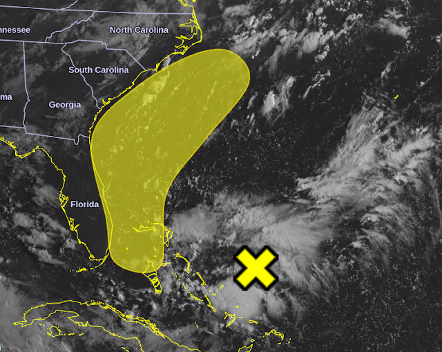
Closer to home, there's a disturbance near the Bahamas that has a slim chance of becoming a tropical cyclone and will approach Florida this weekend. If nothing else, it will bring elevated chances of heavy rain to the Florida peninsula starting on Friday.  (Miami has already had its 9th wettest August on record, with 11 days to go!)

The yellow X marks the approximate center of the disturbance today, while the yellow filled "blob" is the area where tropical cyclone formation might occur in the coming five days.