30 November 2017

The Atlantic hurricane season from hell is finally over

Today is the last official day of the Atlantic hurricane season. Since I started writing and sharing updates on tropical Atlantic activity in 1996, I've written approximately 1,160 updates spanning 345 tropical cyclones, including 163 hurricanes, 75 major hurricanes, and 40 retired storm names. I was honored to have been invited to write blog posts for the New York Times for four years and then for the Washington Post for six years and counting.  Thank you for your continued interest!

My 22nd annual season summary is available on WaPo's Capital Weather Gang blog, and is a tag-team effort with long-time friend and colleague Phil Klotzbach and CWG founder/editor Jason Samenow:

The Atlantic hurricane season from hell is finally over


06 November 2017

After a one-week hiatus, the tropics have sprung back to life

Not surprisingly, another tropical cyclone has formed in the Atlantic.  Tropical Depression 19 is located in the central Atlantic, far from land; it is centered about 850 miles east of Bermuda and 1400 miles southwest of the Azores.  The Depression is embedded in moderately strong vertical wind shear, as evident in the satellite image below (the thunderstorm activity is displaced east of the low-level circulation center).


It is expected to continue to strengthen to a tropical storm as soon as later today, at which point it will become Tropical Storm Rina, the season's 17th named storm.  While that storm count is well above average for a season, 2010, 2011, and 2012 each had 19 named storms. The official hurricane season ends at the end of the month, but as I mentioned in a previous post, these hyper-active seasons are also more prolific in the late-season and post-season timeframes.

TD19 is forecast to strengthen slightly as it heads off toward the northeast, but then transition to an extratropical cyclone by mid-week.  It *could* contribute just enough ACE (Accumulated Cyclone Energy) to push the 2017 season into 6th place overall, nudging out 2004, but still behind 1933, 2005, 1893, 1926, and 1995.  It will be close.


The name "Rita" was retired after the 2005 season, and replaced with "Rina" (how creative, right?) for the 2011 list. In 2011, Rina became a major hurricane in the western Caribbean in late October, and now, assuming this system does get upgraded, 2017's Rina will innocently come and go, allowing the name to show up again on 2023's list.


31 October 2017

Hurricane season usually winds down in November, but this hasn’t been a normal season

NOAA’s definition of hurricane season spans half the year, from June 1 through November 30. Those dates were chosen to encompass the vast majority of storms and activity, but it doesn’t always catch everything. During these hyper-active seasons, we are nearly four times more likely to get a named storm after Halloween.
More details on the climatological tail end of active seasons is available on the Capital Weather Gang blog: 

Hurricane season usually winds down in November, but this hasn’t been a normal season


27 October 2017

A tropical disturbance is brewing in the Caribbean, will impact South Florida on Saturday

The same tropical disturbance I've been watching for over a week (and the subject of the previous post on Tuesday) is now getting somewhat more organized and will head northward.  The full update is available on the Capital Weather Gang blog:

A tropical disturbance is brewing in the Caribbean, will impact South Florida on Saturday


24 October 2017

The western Caribbean is a hot spot for October tropical storms, and one soon could form

An update on a developing disturbance in the southwestern Caribbean Sea, as well as a reminder of the 12-year anniversary of Hurricane Wilma's Florida landfall, is available on the Capital Weather Gang's blog:

The western Caribbean is a hot spot for October tropical storms, and one soon could form


18 October 2017

21st Anniversary

I was reminded that this week marks the 21st anniversary of this blog... it started in mid-October 1996 during Hurricane Lili as a simple email to a handful of interested friends and family.  I was a junior in college with no formal education in tropical meteorology (I was majoring in physics and astronomy).

The emails offered a "one-stop shopping" experience for people who didn't want to go hunting for the current activity and forecasts themselves (there were no smartphones, and the internet and web browsers weren't what they are now).  There were no images or graphics in the updates back then.  The email distribution list that I started in 1996 is still in use today, and even has some of the original subscribers! At the time, I had no intention of continuing it into 1997, let alone 2017.

This is now the 22nd consecutive year that I've been doing this, and it's been fun!  The nearly 1200 updates have spanned 344 Atlantic tropical cyclones, in case anyone was counting.

Incidentally, I saved all of the hurricane-related newspaper articles in the Reading Eagle from 1996, and here is one from October 18, 1996:


I also printed basin-wide satellite images most days that season (and still have all of them)... The Weather Channel had them available on their website.  Here is one from October 17th showing Hurricane Lili south of Cuba:


11 October 2017

09 October 2017

Tropical Storm Ophelia forms west of the Azores


The season's 15th named storm, Ophelia, formed about 860 miles west-southwest of the Azores on Monday.  This has been a feature of interest for several days, and it finally consolidated and took on tropical characteristics.  It is forecast to remain over the open ocean and is absolutely no threat to land.  Right now it is embedded in strong vertical wind shear and is disorganized.

The environment should become more favorable later in the week, and Ophelia could easily become the season's 10th hurricane. Not too many seasons ever get that many hurricanes: 2012 had 10, 2010 had 12, 2005 had 15, 1998 had 10, 1995 had 11, etc.  If it does become a hurricane, it would incredibly be the 10th *consecutive* storm this season to reach hurricane status! The steering currents are weak in the region, so we could still be taking about Ophelia next Monday and beyond... and still near the Azores.

After Nate and now the beginning of Ophelia, the season's total Accumulated Cycle Energy (ACE) is up to 254% of average for the date.  And we are just at the beginning of October, a month that historically has proven that it cannot be dismissed; some of the strongest hurricanes on record have occurred during October.


Deeper in the tropics, an easterly wave that we've been watching since it left Africa on Oct 2nd continues to track quietly across the tropics, and is still expected to reach south Florida this weekend (the model consistency on this is remarkable, going back to the middle of last week).  Models bring the disorganized wave north of the Leeward Islands, across the Bahamas on Thursday-Friday, then across the Florida peninsula on Friday-Sunday.  As of now, there is no indication that it is anything of concern, but it's worth keeping an eye on it and at least expect a breezy and wet weekend in south Florida.


07 October 2017

Hurricane Nate racing toward landfall, bringing big storm surge concerns


Nate strengthened as it passed through the Yucatan Channel and was upgraded to the ninth hurricane of the season late Friday night.  As of Saturday's 5am EDT advisory, maximum sustained winds are 80mph and tropical storm force winds extend 115 miles from the center on the east side. Those TS-force winds will arrive on the coastline by mid-late afternoon, so all preparations and evacuations must be carefully rushed to completion.

Landfall is expected to occur late Saturday night near Biloxi, putting Gulfport, Mobile, New Orleans, and Pensacola also at risk for significant impacts.  It is moving rapidly to the north at 22mph so impacts such as storm surge will be much greater to the right/east of where it makes landfall... such as Mobile Bay which could see up to a 9-foot storm surge. Unfortunately, locations from Grand Isle LA to Panama City FL will have high tide around midnight, coinciding with landfall and peak storm surge... maximizing coastal inundation anywhere east of the landfall point.


Hurricane Nate could reach Category 2 intensity today, but if it takes full advantage of the hot Gulf water and low wind shear, it could even reach Category 3 intensity (115mph+). Long, updating radar loops from the Gulf coast are available at http://andrew.rsmas.miami.edu/bmcnoldy/tropics/radar/

Nate's incredible similarity to the infamous 1916 Gulf Coast Hurricane so far is haunting:
https://twitter.com/BMcNoldy/status/916386485363978241

This is also now the first season to have 9+ hurricanes since 2012 (which had 10), and then before that there were 12 in 2010, 15 in 2005, etc.

Elsewhere, an area way out over the northeastern Atlantic, west of the Azores, could become a subtropical cyclone in the coming days, but is no threat to land.  The next name on the list is Ophelia.

Water vapor image of Invest 91L, a developing low pressure system southwest of the Azores.


04 October 2017

Tropical Storm Nate expected to form Wednesday and may strike U.S. Gulf Coast as a hurricane Sunday

The system in the southwestern Caribbean that we've been watching for a WEEK has finally developed and is now Tropical Depression 16... could become Tropical Storm Nate later today.  My full update is available on the Capital Weather Gang blog:

Tropical Storm Nate expected to form Wednesday and may strike U.S. Gulf Coast as a hurricane Sunday


26 September 2017

Back in gear, and watching two active hurricanes

The last update and blog post I wrote was on September 7.  Between Hurricane Irma house preparations, subsequent loss of power and internet, then a 10-day vacation to Ireland, I have been largely offline since then. I started writing these updates in 1996, so this is the 22nd year, and in all that time, I never had a lapse this long during such heightened activity.  But I have no doubt that if you needed the most current information and forecasts that the NHC website was your place to go, and for blog posts to summarize activity, the Capital Weather Gang is a great stop.  I hope everyone reading this who was affected by the recent tropical cyclones is doing well and getting back to normal, but I realize that in some places, that may take a long time.

A lot has happened since the 7th (Katia's Mexico landfall, Irma's Florida landfall, Jose's long loop, Lee's little loop, Maria's landfall on the northern Leewards and Puerto Rico).  To summarize the activity from Irma through Maria, here is a map showing all of their tracks... note that Lee (14L) and Maria (15L) are still active and are both hurricanes:


For current activity, Category 1 Hurricane Maria is centered just off the North Carolina coast... tropical storm and storm surge warnings are in effect for the Outer Banks.  It is forecast to move away from the U.S. east coast.  Category 2 Hurricane Lee is centered about 1200 miles east of Maria and is not a threat to any land.

Hurricane Maria and Hurricane Lee on Tuesday afternoon.
Additional tropical cyclone development is unlikely within the next five days, but there is a disturbance that will crawl across south Florida from Friday through Monday.  It will bring elevated chances of thunderstorms and heavy rain... though the odds of it becoming even a tropical depression are slim.

Seven-day rainfall forecast, valid Tuesday morning through next Tuesday morning. (NOAA/WPC)
The season has now had 13 named storms, 8 hurricanes, and 4 major hurricanes... and in terms of ACE (Accumulated Cyclone Energy), the season is at a whopping 242% of average for this date. We are on par to compete with the hyper-active 1995 and 2004 seasons (the 2005 season is in a league of its own).  Unfortunately, the season has also come with numerous landfalls -- only Arlene, Don, Gert, Jose, and Lee have not passed directly over land.


07 September 2017

Category 5 Irma stays on perilous path toward Florida, hurricane watch issued

My Thursday morning update on Hurricane Irma and other activity across the tropics (Hurricane Jose and Hurricane Katia) is available on the Capital Weather Gang blog:

Category 5 Irma stays on perilous path toward Florida, hurricane watch issued

I will probably post something on Friday, and perhaps Saturday, but I do not expect to have power or an internet connection by Saturday evening. Please stay tuned to the National Hurricane Center for the latest.


06 September 2017

Extreme Category 5 Irma crashes into Caribbean, sets sights on Florida and Southeast U.S.

My Wednesday morning update on Hurricane Irma is available on the Capital Weather Gang blog:

Extreme Category 5 Irma crashes into Caribbean, sets sights on Florida and Southeast U.S.

Tropical Storm Jose is also out there east of Irma, and Tropical Storm Katia is in the Gulf of Mexico.  You can get the scoop on those at http://www.nhc.noaa.gov/


05 September 2017

Irma becomes monster Category 5 hurricane as it heads for Leeward Islands


Hurricane Irma continues to strengthen over the warm tropical Atlantic ocean, and is now a rare Category 5 hurricane with 175 mph winds.  It is also closing in on the northern Leeward Islands, where it is forecast to make a direct impact early Wednesday. Beyond that, Irma also threatens the Virgin Islands, Puerto Rico, the Dominican Republic, Haiti, Cuba, the Bahamas, and the United States.  South Florida is on high alert for major hurricane conditions this weekend.


Hurricane warnings are in effect for the northern Leeward Islands, the Virgin Islands, and Puerto Rico... new warnings will be added to the west as the storm tracks just north and parallel to the Greater Antilles. Storm surge heights of 7-11 feet are possible in the warning areas, as well as heavy rain that can produce flash flooding and mudslides.

The environment will support an extremely intense hurricane for the foreseeable future, and Irma could dip in and out of the Category 5 classification (sustained winds in the eyewall exceed 157 mph) over the next few days. But regardless of the exact category rating, it will be extremely dangerous and will produce the full gamut of hurricane hazards from huge storm surges to torrential rain to severe winds capable of causing catastrophic damage.

The longer-range ensemble guidance is in strong agreement on a sharp northward turn on Sunday morning, but the precise timing and location of the turn has huge implications for Florida.


As of Tuesday morning, it is impossible to say with certainty if Irma will track up along the eastern side of the Florida peninsula, the western side, or straight up the peninsula.  For a major hurricane, the exact track of the relatively small eyewall is really important -- the largest storm surge will occur to its right and the most violent winds in the storm are confined to that annulus around the calm eye. All of Florida, and especially south Florida, should be preparing for a major hurricane landfall on Sunday.  Tropical storm force winds will arrive later on Friday at which point outdoor activities are dangerous.

Beyond the weekend, the scenarios really depend on which side of Florida it tracks. But for now, it's safe to say that the southeast U.S., including the Florida panhandle, Georgia, and the Carolinas should also brace for potential impacts such as flash flooding, storm surge, strong winds, etc.


04 September 2017

Irma will start affecting land every day from Wednesday onward


Irma is still a Category 3 hurricane and is centered just 600 miles east of the Leeward Islands as of Monday morning.  The outermost rainband is about 250 miles from the islands as of this writing (and satellite loop below). Hurricane watches will be upgraded to hurricane warnings later today as dangerous tropical storm conditions should begin in those islands later tomorrow with the worst conditions arriving on Wednesday.


Over the past couple of days, the key feature that will determine how soon Irma turns toward the north -- the subtropical ridge -- has been expected to remain stronger for longer, keeping Irma stuck to the south. The pre-US recurvature scenario looks less likely all the time now.

Five-day track forecasts from the National Hurricane Center over the past couple of days (Saturday morning through Monday morning).
This is bad news for a lot of places... from the Leeward islands, Puerto Rico, Dominican Republic, Haiti, Cuba, the Bahamas, and then the U.S.

Before diving into the specifics, the latest model ensemble guidance does indicate a later northward turn than was the case a couple of days ago.  One tidbit to be aware of is that the mechanism that will provide a break in the ridge is a trough coming in from off the U.S. west coast.  Days ago, that feature was not very well sampled with data to feed into the models.  Now that it is entering the western U.S., it is coming into a more data-rich environment and models get a better grip on its structure.  It is forecast to dive from the Pacific northwest down to the southeast US between Wednesday and Monday, eroding the ridge as it does so.

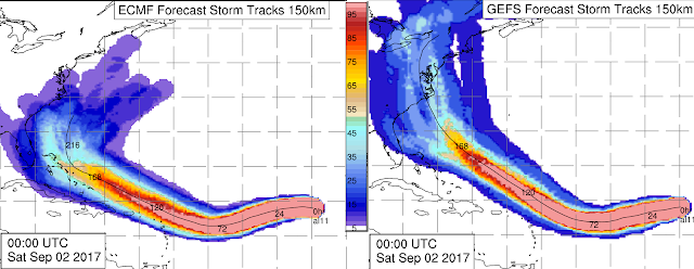
Ten-day track probabilities calculated from the ECMWF ensemble (left) and the GFS ensemble (right). (B. Tang, UAlbany)
Both the European and the U.S. global model ensembles still include a sharp turn to the north, but the most recent runs are near the Florida peninsula, and they differ slightly on the timing.  At this point, Florida is definitely at risk from at least a close encounter if not a direct landfall from a major hurricane. The southeast U.S. coast is also still at an elevated risk of significant impacts.

As far as timing goes, south Florida would be looking at the worst conditions on Sunday-Monday (10th-11th), with tropical storm force winds arriving on Saturday (9th).  It remains to be seen what "worst" means as that is dependent on precisely how close the eyewall gets to a certain location.

If it turns north just prior to reaching the Florida peninsula, the Carolinas become a likely target, and the worst conditions would be on Monday-Tuesday (11th-12th) with tropical storm conditions arriving Monday (11th).

At this point, a westward track into and across the Gulf of Mexico seems very unlikely, but given the model trends, I wouldn't rule it out completely just yet.  However, note the scenario where the storm turns north just after passing the Florida peninsula and tracks up the west coast of Florida.  This threat cannot be ignored either.

If it seems like the "I" storms are historically troublesome, you'd be right.  Storms that begin with "I" are in fact the most retired of all the storms.  Names are permanently retired from the rotating lists if they were particularly deadly or devastating.


Breaking it down by month, storms that made their impact during September have also been the most commonly retired.


And finally, breaking it down by peak intensity, storms that reach Category 4 intensity are also the most frequently retired.


02 September 2017

Irma still a strong hurricane and forecast to strengthen more

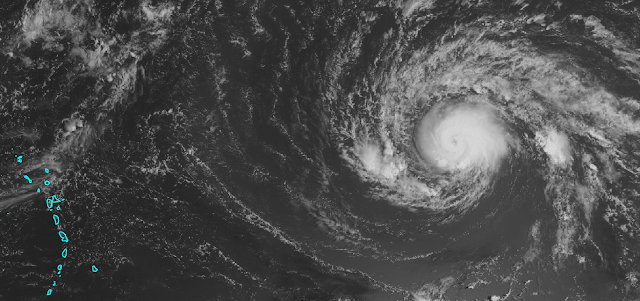
Regional satellite image with Hurricane Irma on the right and the Lesser Antilles on the left. (NASA)
As of early Saturday morning, Irma was a Category 2 hurricane packing 110 mph winds.  It is centered about 1300 miles east of the Lesser Antilles and tracking toward the west at 14 mph.  It is forecast to maintain a general westward motion through early next week then gradually turn toward to the northwest, hopefully before reaching the Leeward Islands.


The National Hurricane Center forecast brings it up to Category 4 intensity by Wednesday, but it could happen sooner.  From this point forward, it will encounter warmer and warmer ocean temperatures, and the vertical wind shear remains quite low.

The long-range model guidance has shifted slightly north again, meaning an earlier recurvature appears more likely -- though not certain.  Recurvature is when storms in the deep tropics that move generally westward start turning toward the north and the mid-latitudes.

Both the European and the U.S. global models and their ensembles have significantly backed off on the threat of this storm entering the Caribbean and the Gulf of Mexico, shifting the highest probabilities toward the U.S. east coast or offshore.

Ensemble-based track probabilities out to 10 days from the ECMWF (left) and GFS (right). (A. Brammer, UAlbany)
It is absolutely too soon to place much weight on these projections right now, but there is decent inter-model agreement through the next four days.  Beyond that, the spread increases, with some heading toward the Bahamas and some up toward Bermuda.

For the U.S. east coast, **IF** the storm were to head that direction, the Sep 9-11 timeframe is the most likely as of now for landfall or a close encounter, with options ranging from south Florida (earlier in that window) to New England (later in that window).  Early next week, the Leeward Islands and Puerto Rico could be affected, then the Bahamas, the entire U.S. east coast, and Bermuda should be watching this as the days go on, and to take care of routine hurricane preparedness tasks now, before it's urgent.

You can always find the most recent NHC forecast at http://www.nhc.noaa.gov/


30 August 2017

After disastrous rain around Beaumont and Port Arthur, Harvey surges inland

I did not have a chance to write a full update on Harvey today, but it made another landfall in the early morning hours near Cameron, LA.  Extremely heavy rain sat over the Beaumont and Port Arthur (TX) area for hours, producing even worse flooding than what Houston experienced.

Radar and satellite images from the second landfall:
https://twitter.com/BMcNoldy/status/902828833690222593

Archived and ongoing long radar loops:
http://andrew.rsmas.miami.edu/bmcnoldy/tropics/radar/

A more detailed update on Tropical Storm Harvey, written by Capital Weather Gang editor and colleague Jason Samenow is available at:

After disastrous rain around Beaumont and Port Arthur, Harvey surges inland


Tropical Storm Irma forms in Atlantic, and still watching Gulf of Mexico early next week

An update on newly formed Irma in the far eastern Atlantic and the potential for another storm early next week in the Gulf of Mexico is on the Capital Weather Gang blog:

Tropical Storm Irma forms in Atlantic, and still watching Gulf of Mexico early next week


29 August 2017

Forecasters warily watching the eastern Atlantic and Gulf of Mexico for new tropical storms

Aside from Harvey, there are other areas of the Atlantic basin that need to be watched closely... my second update today focuses on these two systems and is available on the Capital Weather Gang blog:

Forecasters warily watching the eastern Atlantic and Gulf of Mexico for new tropical storms


Maps of rainfall totals in Texas look like maps of snowfall totals after a Nor'easter

Rainfall totals from Friday morning through Tuesday morning. (SERCC)
As we enter Day 5 of heavy rain in Texas, the totals are staggering and still accumulating.  As of late Tuesday morning, several stations are referenced in a NWS list that are now at over three feet of rain:

MARYS CREEK AT WINDING ROAD      49.20
CEDAR BAYOU AT FM 1942           48.64
CLEAR CREEK AT I-45              47.20
DAYTON 0.2 E                     46.08
SANTA FE 0.7 S                   45.02
HORSEPEN CREEK AT BAY AREA BLVD  44.96
FRIENDSWOOD 2.5 NNE              42.76
PASADENA 4.4 WNW                 42.58
HOUSTON WEATHER FORECAST OFFICE  42.11
WEBSTER 0.4 NW                   41.77
LEAGUE CITY 2.7 NE               41.66
BAY AREA BLVD AT HORSEPEN CR     40.64
BERRY BAYOU AT NEVADA            40.32
BERRY B FOREST OAKS              40.28
VINCE BAYOU AT PASADENA          39.29
LITTLE VINCE BAYOU AT JACKSON    39.00
TURKEY CK AT FM 1959             37.96
MIDDLE BAYOU GENOA RED BLUFF     37.76
AMAND BAYOU AT NASA ROAD 1       37.68
JACINTO CITY                     37.60
LITTLE CEDAR BAYOU AT 8TH ST     37.32
TELEPSEN                         36.60
FIRST COLONY 4 WSW               36.34
BEAMER DITCH HUGHES RD           36.32
LA PORTE 1 N                     36.24
TAYLOR LAKE AT NASA ROAD 1       36.23

The report of 49.2" became the all-time record holder for highest rainfall amount associated with a landfalling tropical cyclone in the continental United States. The previous top three in the U.S. were...

Amelia 1978: 48.00" (Medina, TX)
Easy 1950: 45.20" (Yankeetown, FL)
Claudette 1979: 45.00" (Alvin, TX)

Storm-total rainfall maps for Amelia 1978, Easy 1950, and Claudette 1979. (David Roth, NOAA/WPC)
The accumulation map looks more like inches of snow after a strong Nor'easter, not inches of rain in a few days. A huge area is blanketed (or submerged in this case) by totals of 1 foot or greater.  Maxima are now over 4 FEET!!

The primary reason for these incredible amounts is that Harvey has barely moved.  The center is now just 150 miles from where it made landfall on Friday night.  It has also been a tropical storm or hurricane for 84 hours AFTER making landfall. If you add up all of the time it was a named storm prior to landfall (including the eastern Caribbean part) you get 90 hours.  Later today, it will have spent more time as a tropical storm or higher after landfall than it did prior to landfall.

Typically, storms make landfall and keep moving.  People have calculated bulk averages for "typical" rainfall amounts from landfalling storms.
 - In the late 1950s, R. H. Kraft introduced a rough guideline for maximum rainfall totals from a landfalling tropical cyclone: divide 100 by the forward speed of the storm in knots.  So for Harvey which was moving at 6 kts (7 mph) when it made landfall, you would get a maximum of 16.7 inches (if it kept moving at that speed).
 - David Roth (NOAA/WPC) created a chart using storms from 1991-2005 and found that the average landfalling storm produced 13.3 inches of rain.

(David Roth, NOAA/WPC)
But when a storm does not keep moving, these climatology-based estimates break down.  Or do they?  Using the Kraft rule, and Harvey's motion since landfall (150 miles in 84 hours = 1.6 kt), you would get a maximum of 64.4 inches.  We're still 14 inches shy of that extremely crude estimate, but it's also not over yet.
The forecast over the next 3 days still includes impressive totals over eastern Texas.


Today through Thursday, the flooding risk remains high in eastern Texas but also expands eastward to Louisiana, Mississippi, and Alabama.  Strong rainbands will affect these areas in the coming days as Harvey continues to tap into the endless moisture supply in the Gulf of Mexico.


With the center back over water now, it should draw in less dry air than it did on Monday, and a second landfall is forecast to occur on Wednesday afternoon near Lake Charles, LA. Tropical storm warnings and storm surge watches cover much of coastal eastern Texas and Louisiana.  The storm is expected to finally get kicked out of the area on Thursday then accelerate off to the northeast.


28 August 2017

Tropical storm warning for N.C. Outer Banks as Irma may soon form

The update on a disturbance off the northeast Florida coast is available on the Capital Weather Gang blog:

Tropical storm warning for N.C. Outer Banks as Irma may soon form


Tropical Storm Harvey moving back over water, new wave emerging from Africa

Since Sunday, Harvey has barely moved; in fact it has actually drifted back toward the south... back toward the warm Gulf water.  As of Monday morning, the center is indeed over water again... and Harvey has incredibly maintained tropical storm status continuously since making landfall on Friday night.


However, something that is sparing the hardest-hit areas for now is the storm's circulation is wrapping in drier air from the west which is greatly diminishing rainband development.


Models are in agreement that Harvey will re-intensify slightly over the Gulf of Mexico during the next couple of days before making another landfall on eastern Texas on Wednesday morning.  Given the current structure and dry air intrusion, it is very unlikely that Harvey will regain hurricane status... but the threat of heavy rain and additional flooding lingers.

The Houston area could receive at least another 20 inches of rain, on top of the 25-30 inches that has already fallen there. The flood risk will also migrate eastward into Louisiana this week. As the National Weather Service stated on Sunday morning, "This event is unprecedented and all impacts are unknown & beyond anything experienced."


The tropical disturbance I've been discussing for the past couple of weeks that approached south Florida last week is finally moving along, and may also finally become a named storm as it heads for the Carolinas.  My update on what may become Tropical Storm Irma will be on the Capital Weather Gang blog later today, and I'll have a separate post on that... stay tuned.

Much further east, a new healthy tropical wave has just exited the African coast — model guidance indicates that there is a good chance it will become the next named storm later this week (Irma if the Carolinas low doesn’t get it first, or Jose if it does).


Over the past 50 years, the average date for formation of the ninth named storm is September 30, and the tenth is October 14.  In terms of Accumulated Cyclone Energy, or ACE, the season is now at 97 percent of average for this date.


27 August 2017

Forecasts of Harvey's impact have been spot-on, which is really bad news for Texas

Since last Tuesday, the key message associated with Harvey was that historic rainfall and catastrophic flooding was expected over a large area in eastern Texas.  That message remained steady, even when Harvey was a tropical depression, and through its Category 4 hurricane landfall.  Unfortunately, now we are seeing the beginnings of that outlook come to fruition.

Overnight, the Houston area experienced unimaginably heavy rain, over 20 inches in some places in just a few hours.  The city is literally underwater today.  And there are days more of rain to come.  This is far from over.

Rainfall totals from Friday morning through Sunday morning.
Harvey is still forecast to remain stationary for the next few days... perhaps starting to drift northward on Wednesday.  The heavy rainfall we've been seeing is not going to end anytime soon.  The forecast for the next five days shows that areas around Houston could see an additional 1-2 feet of rain.


As of Sunday morning, Harvey is still a tropical storm with 45mph winds, and is centered about 65 miles east-southeast of San Antonio, 130 miles west-south of Houston, and 80 miles north of Corpus Christi.  But the specific storm center is not the concern, it's the sprawling rainbands that extend outward for hundreds of miles. Since the storm is still so close to water, the circulation is drawing in tropical moisture from the steamy Gulf of Mexico... an endless fuel source.


Aside from the torrential rain that rainbands produce, they are also well-known to produce tornadoes.  At least a dozen tornadoes have been reported in eastern Texas and western Louisiana since Saturday morning.

The latest forecast and warnings can be found on the National Hurricane Center website.  I have long regional radar loops available at http://andrew.rsmas.miami.edu/bmcnoldy/tropics/radar/

There have been the usual "this came out of nowhere" and "we didn't think it would be this bad" statements from officials.  This is very unfortunate and irresponsible... this event was very well forecast and advertised for several days in advance.  Forecasts of widespread 15-20" totals with some areas seeing 40 inches or more will verify.

As someone who tries to get this information out, it's frustrating and infuriating when people who should know better claim they had no warning.  The general public seems to fear the category rating of a storm more than the rainfall forecast, yet rain is historically responsible for 3.3 times more fatalities than wind for hurricanes hitting the United States.  Storms like Harvey may help to make the public more aware that rain is a very big deal, even though it's not a part of the Saffir-Simpson category rating.

To give an idea of how consistent the messaging has been, here are some quotes from my posts since Friday the 18th (still lots of uncertainty on the 18th):

Aug 18: "Beyond the Yucatan peninsula encounter, things get hazy... but the possibility exists that it could become a hurricane in the Gulf of Mexico in about a week."

Aug 22: "Even if Harvey does not reach hurricane intensity, the rainfall associated with it is still expected to be a big problem. Over coming week, large areas from the Mexico border over to the north-central Gulf coast could see very substantial rainfall totals."

Aug 23: "By far, the hazard of greatest concern with this system is its rainfall. While the center of the storm is expected to reach the coast Friday afternoon, heavy rain is likely to begin in the morning. Because of weak atmospheric steering currents, computer models indicate Harvey will stall over the Texas-Louisiana area through most of the weekend, at least, dispensing potentially incredible amounts of rain. ... Some computer model forecasts suggest the storm could linger over Texas through early next week, producing astronomical rainfall amounts between 30 and 50 inches in areas."

Aug 24: "In addition to damaging winds, the National Hurricane Center said it expects “catastrophic and life-threatening” flash flooding along the middle and upper Texas coast. An incredible amount of rain, 15 to 30 inches with isolated amounts of up to 40 inches, is predicted because the storm is expected to stall and unload torrents for four to six straight days. In just a few days, the storm may dispense the amount of rain that normally falls over an entire year, shattering records."

Aug 25: "The impacts from this storm are anticipated to be almost unfathomable.  A storm of this intensity would be bad enough, but all guidance suggests that it will stall for several days right near the coast due to a lack of mid-level steering winds.  The rainfall forecasts are ominous, and if they come even close to verifying, this will be a storm for the history books. In this map below, which shows the cumulative rainfall forecast over the coming week, a large area is saturated at the >20 inches contour, but specific locations could see 3-4 FEET of rain.  Widespread and prolonged life-threatening flooding appears inevitable."

Aug 25: "Hurricane Harvey could be on par with 2005’s Hurricane Katrina in terms of economic impact. The Houston area and Corpus Christi are going to be a mess for a long time."

Aug 26: "A stationary tropical cyclone is a very bad thing... and widespread life-threatening flooding is anticipated over the coming days.  The latest 5-day rainfall forecast places over 20 inches of rain in the same areas that have been getting heavy rain since Friday morning. Locations within this area could see up to 40 inches.  Flooding might not be as dramatic as a hurricane making landfall, but it's more deadly."

The point of rehashing this is certainly not to say "I told you so", but rather to discredit the irresponsible and inaccurate messages coming out now that the event is actually happening.  This did not catch anyone offguard.  It could be the greatest flooding disaster in U.S. history.


26 August 2017

Harvey made landfall as Category 4 hurricane, but the disaster is far from over

At about 10pm local time on Friday, Harvey made landfall near Rockport, TX.  It rapidly intensified for two days leading up to landfall, and ended up crossing the coastline with 130 mph winds... a Category 4 hurricane.  It was the strongest hurricane hit the U.S. since Charley in 2004, and the strongest hurricane to hit Texas since Carla in 1961.

Infrared satellite image of Hurricane Harvey at the time of landfall.
Just two days prior to this, Harvey was a tropical depression with 35 mph winds.  Although it was forecast to become a hurricane by landfall, this extreme rate of intensification is unpredictable.  Hurricane watches were issued on Wednesday morning for the appropriate section of coastline... that is the maximum lead time used in tropical cyclone watches.
Hurricane watches were issued for Texas coast on Wednesday morning for a forecast landfall on Friday night.  Harvey was a tropical depression at this point.
As of early Saturday afternoon, Harvey is still a Category 1 hurricane and has already stalled over Texas.  It's extremely important that people in the area do not breathe a sigh of relief now that landfall is behind them.

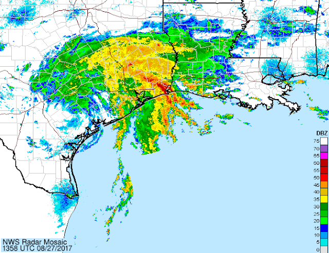
Regional radar image from midday Saturday.
The big story has been and still is the rain.  This part of the event is just beginning to unfold.  The forecast still calls for Harvey to remain essentially stationary for at least the next five days.  From Friday morning through Saturday morning, rainfall totals are already impressive, especially in areas just north of Corpus Christi.  I have numerous long radar loops available at http://andrew.rsmas.miami.edu/bmcnoldy/tropics/radar/

Observed rainfall totals from midday Friday through midday Saturday.
A stationary tropical cyclone is a very bad thing... and widespread life-threatening flooding is anticipated over the coming days.  The latest 5-day rainfall forecast places over 20 inches of rain in the same areas that have been getting heavy rain since Friday morning. Locations within this area could see up to 40 inches.  Flooding might not be as dramatic as a hurricane making landfall, but it's more deadly.

Cumulative rainfall forecast over the coming five days.
Like most major hurricanes, Harvey originated from Africa.  The easterly wave that went on to become Harvey left the African coast on August 12 and was a trackable feature and/or tropical cyclone the entire time.  Storms like this do not come out of nowhere.


Harvey was also the first major hurricane to hit the United States since Wilma in 2005, so it ended the astounding record span of nearly 12 years between such landfalls.