At 03Z today, the area of disturbed weather that was east of Puerto Rico yesterday was upgraded to Sub-tropical Storm Olga. Intensity is now estimated at 40kts and 1005mb, and since the strongest winds are still quite far from the center of circulation, it is it classified as purely tropical. STS Olga is forecast to weaken as it heads W not only over Jamaica, but also into much stronger vertical wind shear.
There's a long radar loop showing Olga's development near Puerto Rico available at: http://einstein.atmos.colostate.edu/~mcnoldy/tropics/olga07/Olga_10-11Dec07.gif
Please visit my tropical Atlantic headquarters.
11 December 2007
10 December 2007
New disturbance near Puerto Rico...
Although the Atlantic hurricane season officially ended ten days ago, the tropical atmosphere still has a little kick in it yet. A potent yet asymmetric 1010mb Low is presently located just a couple degrees east of Puerto Rico. It is in weak southwesterly wind shear, and has a window of opportunity of about 24-36 hours to organize before shear increases. It's over 27.5C water and should remain over that for the next few days as it heads WNW at 10kts. If this gets named, it would become Olga, the 15th named storm of the season.
You can track the precipitation around this disturbance from the San Juan long-range radar: http://einstein.atmos.colostate.edu/~mcnoldy/tropics/olga07/Olga_10Dec07.gif
If you recall, the season started off on May 9 with Andrea... three weeks before the official beginning of Atlantic hurricane season. Should Olga form in December, we'd really have a long tropical season!
Up through this potential storm, and using the currently available "best track" data from NHC (not all storms have been reanalyzed post-season yet), we had 14 tropical storms, 6 of which became hurricanes, and 2 of those became major hurricanes. Combining these numbers and their respective longevities allows us to compare the season to a "normal" season (net tropical cyclone activity = NTC). In this comparison, 2007 was 95.1% of normal, or about as average as it gets! If the current disturbance gets named, let's suppose for a day, that percentage goes up to 97.2. Furthermore, neither Dean nor Felix have final reports completed yet, and any change in the major hurricanes could change the NTC a bit.
Please visit my tropical Atlantic headquarters.
27 September 2007
Karen weakens, Lorenzo forms...
The much-anticipated vertical shear has finally met Karen head-on. The low-level center is now displaced 3 degrees to the west of the deep convection and completely exposed, thanks to 25kts+ of westerly vertical wind shear (defined as the vector difference between the 850mb winds and the 200mb winds over the system). The intensity has fallen to 55kts and 1004mb. It's tracking WNW at 10kts, and the forecast is for heading NW and weakening/maintaining intensity. However, after this confrontation with the trough (5+ days) Karen could warrant a much more cautious watch as a ridge moves over the storm and decreases the shear and steers it more toward the west.
At 18Z today, TD13 was upgraded to TS Lorenzo based on aircraft recon into the storm. This is the twelfth named storm of the season, already above the long-term average of 10 for the season, and there are still 2 more months in the Atlantic hurricane season. Lorenzo has become much more compact, with a very vigorous central core and CDO with cloud tops hitting -80C.
The circulation is still visible from the Alvarado radar at http://smn.cna.gob.mx/radares/radares.html
The latest intensity is 50kts and 1004mb and it still appears to be intensifying. The forecast brings it up to 55kts prior to landfall on Friday night. The primary problem with this storm is the motion: almost none. It is drifting at 2-3kts toward the Mexican coast, and in the meantime will begin to spread very heavy rain throughout central Veracruz and even further inland.
There's a new healthy tropical wave near the Cape Verde Islands (~25W) which exited the African coast on Tuesday. Perhaps of more note is a wave still over land that should exit the coast tomorrow... that one is favored to develop quickly by several global models.
Please visit my tropical Atlantic headquarters.
26 September 2007
Karen strengthening, TD13 forms...
Karen has made surprising strides in organization over the past 24 hours. A struggling 35kt storm yesterday at this time, it's now a compact 60kt storm with a developing eye... nearly a hurricane. It now has centralized deep convection, but the outflow is asymmetric owing to the westerly vertical shear. The estimated central pressure is 990mb, and Karen is now expected to reach hurricane strength later today. It's moving WNW at 11kts, and that motion should continue over the next several days, perhaps becoming more NW at times. The stronger vertical shear is still forecast to impinge on the storm late this week into the weekend, which could weaken it a bit, but by early next week, the trough will pass by and Karen might find itself on a strengthening trend again.
VIS satellite image of Karen: http://www.ssd.noaa.gov/goes/flt/t1/vis-l.jpg
The area of disturbed weather in the Gulf that I first mentioned on Monday has been upgraded to TD13, and is very close to being upgraded to TS Lorenzo. Intensity is 30kts and 1006mb and is forecast to drift very slowly toward the west into Mexico as a strong tropical storm on Friday. You can keep an eye on it from Alvarado's radar at http://smn.cna.gob.mx/radares/rad-alva.gif
The other area I was discussing before that was near Puerto Rico is now over the Dominican Republic: poorly organized and highly sheared. However, as I pointed out yesterday, this should not be dismissed in the long term. IF the circulation can survive the trip over Hispaniola, the hurricane "sweet spot" near the Bahamas could re-energize the system in a few days.
Lastly, a new area of interest has popped up off the southern Florida peninsula that warrants a close eye. It is in an environment conducive for genesis, and this could track across the peninsula as a VERY rainy tropical storm. If this does rapidly organize, the name/number on deck is 14/Melissa.
Radar image of this disturbance: http://radar.weather.gov/radar.php?rid=amx&product=N0Z&overlay=11101111&loop=no
Please visit my tropical Atlantic headquarters.
25 September 2007
Karen forms in deep tropics...
At 03Z today, the tropical wave near 35W was upgraded to TD12, then to Tropical Storm Karen just six hours later. It remains a minimal 35kt tropical storm now, and convection is fairly shallow and scattered. The vertical shear is very low right now, but is forecast to become excessive by the weekend, halting any attempts at a significant hurricane for the next several days. There is a buffer timeframe however, while the SSTs are warm and wind shear is low enough and before the subtropical jet comes in and kicks up the shear, when the storm could reach hurricane intensity (or after crossing north of the subtropical jet in a few days). It's located near 11N 40W and tracking WNW at 13kts.
Elsewhere, the other two areas of interest are still out there, but not in any rush to get organized. The one near 65W is entering a high westerly vertical shear zone near the northern Leeward Islands, and has a slim chance of making it through intact. BUT, if it does survive the next 2-3 days, it would be one for Floridians to monitor in case it develops near the Bahamas. And the third, now in the west-central Gulf of Mexico, is a 1009mb Low close to Depression status as it drifts very slowly to the west toward the Tampico area. It's over 30C SSTs, in a low-shear environment, and could become TD13 later today or tomorrow.
VIS image of system near northern Leeward Islands: http://www.ssd.noaa.gov/goes/flt/t2/vis-l.jpg
VIS image of system in western Gulf of Mexico: http://www.ssd.noaa.gov/goes/flt/t4/vis-l.jpg
Please visit my tropical Atlantic headquarters.
24 September 2007
Atlantic getting active...
Since my last message, Ingrid, TD10, and Jerry formed. Ingrid began on Sep 12 from an African easterly wave, and struggled against vertical shear and dry air for 5 days until degenerating to a low-level swirl then open wave near the Leeward Islands. TD10 was only around for a few hours on Friday and formed and dissipated near the western Florida panhandle.
Jerry formed this past weekend in the far north central Atlantic, first as a subtropical depression, then transitioned to a weak tropical storm, and is presently undergoing a transition to extratropical. None of the three systems were terribly noteworthy.
Now, there are several interesting items to discuss across the basin, each about 30 degrees apart.
First, there's a 1011mb Low in the southern Gulf of Mexico associated with a larger-scale trough. It's quite active, but strongly sheared. However, the shear is expected to lessen over the next day or two and perhaps allow this system to organize and drift westward toward Mexico. http://www.ssd.noaa.gov/goes/flt/t4/vis-l.jpg
A potent easterly wave that left Africa on Sep 16 has been convectively active the whole trip across the Atlantic, and today is no exception. It's crossing the Windward Islands now, and heading WNW toward Hispaniola. Conditions are favorable for continued strengthening. As it passed by Barbados earlier today, they recorded a pressure of 1009mb and winds of 18kts. You can monitor the passage of the wave from the Martinique/Guadeloupe radar at http://www.meteo.fr/temps/domtom/antilles/pack-public/animation/animMOSAIC2.html. The latest visible satellite image is at
http://www.ssd.noaa.gov/goes/flt/t2/vis-l.jpg
The most well-organized system is an easterly wave out by 9N 35W (exited African coast back on Sep 21). This is in an environment conducive to tropical cyclogenesis: SSTs of 28C and increasing along the future track, moderate vertical wind shear, and an embedded 1007mb Low. It is tracking WNW at 12kts. It should be able to gradually intensify; the only inhibiting factor is increasing shear as a trough nudges its way toward the system in the next few days. Depending on how close the two get, this could be a hurricane or suffer the same fate as Ingrid.
http://www.ssd.noaa.gov/goes/flt/t3/vis-l.jpg
Please visit my tropical Atlantic headquarters.
13 September 2007
TD9 becomes Humberto in a hurry, TD8 treks across deep tropics...
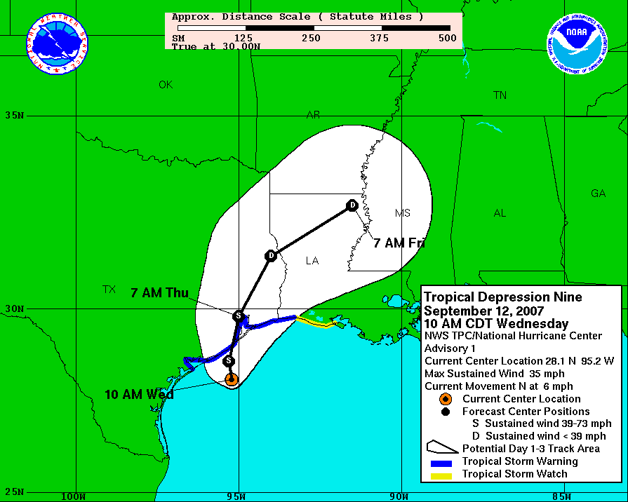
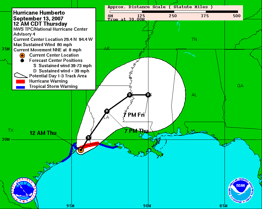
Well, Humberto was a surprise for everyone. There is not a forecaster I know of who would have called for a weak Depression to reach hurricane strength in less than a day and just miles offshore. Wednesday at 15Z, tropical storm warnings were posted for the areas near the newly-formed TD9 (http://www.nhc.noaa.gov/archive/2007/graphics/al09/AL092007_3W_001_0.GIF). The first hurricane warning was posted at 05Z on Thursday morning, just 2 hours before landfall, and without a hurricane watch ever being issued (http://www.nhc.noaa.gov/archive/2007/graphics/al09/AL092007_3W_004_0.GIF). It made landfall at about 07Z as a 75kt hurricane --10kts beyond minimal hurricane strength-- near High Island TX.
This intensification rate is astounding and unprecedented for a storm so close to land. Sustained winds went from 45kts to 75kts in just 18 hours, AND did so near the metropolitan area of Galveston/Houston. Rapid intensification is a challenge to predict, but when it's so close to land, a lot is at stake, and a wrong forecast can cost lives. So far in this storm, one death has been reported: a man outside watching the weather had a metal roof fall on him. It also doubtlessly affected some of the many unprepared oil refineries in that area.
There is a radar loop available at http://einstein.atmos.colostate.edu/~mcnoldy/tropics/humberto07/Humberto_12-13Sep07.gif which shows the whole evolution of Humberto... from weak tropical storm at about 1530Z Wednesday through a 75kt hurricane at 09Z Thursday and ending as a weakening hurricane over land at 13Z Thursday.
TD8 is still holding its ground as a depression, and struggling against hefty vertical wind shear. If and when the shear lets up even a little, all other conditions appear very favorable for it to intensify substantially. It should track a bit north of the Caribbean Sea, which leaves it in the southwest part of the basin by early next week, at which point, the US should a close eye on it. The next name on the list is Ingrid.
Please visit my tropical Atlantic headquarters.
12 September 2007
TD8 and TD9 form...
The African easterly wave I've been mentioning since Friday has finally been upgraded to a Depression. TD8 is now about 1100 miles east of the Lesser Antilles and tracking WNW at 10kts. The estimated intensity is 30kts and 1007mb. It is no immediate threat to any land... over the next 5 days it is forecast to slowly intensify and head WNW-NW, probably missing the Caribbean Sea, unlike Dean and Felix.
Also, an area of disturbed weather that has been meandering westward across the Gulf of Mexico for a few days was also upgraded to a Depression today. TD9 is now heading north and is just off the Texas coast, heading for Houston. It is very close to Tropical Storm intensity, and should be named before landfall later tonight. This could be a huge flooding problem for a very flood-prone metro area.
You can view a radar loop of TD9s approach into Houston at http://einstein.atmos.colostate.edu/~mcnoldy/tropics/humberto07/Humberto_12Sep07.gif
and data from a moored buoy near the mouth of Galveston Bay at
http://www.ndbc.noaa.gov/station_page.php?station=42035
Please visit my tropical Atlantic headquarters.
10 September 2007
Gabrielle forms and hits NC... another storm brewing in deep tropics...
On Wednesday and Friday of last week, I wrote about a potentially developing storm off the southeast coast of the US. On Friday night, it was upgraded to Sub-Tropical Storm Gabrielle and by Saturday afternoon had transitioned to Tropical Storm Gabrielle. It was heading west toward the coast as expected, and made landfall near Cape Lookout, NC midday Sunday as a 45kt tropical storm. It's since been downgraded to a Depression and is getting strongly sheared from the west. The remnant low-level circulation is located about 300 miles east of the DelMarVa peninsula and is being whisked northeastward by an encroaching trough.
Now, the primary area of concern shifts to a strong easterly wave tracking across the deep tropics, presently near 10N 40W.
It exited the African coast last Wednesday, and has been fairly slow to pull itself together. Satellite imagery reveals an anticyclone in place aloft, and a developing low- and mid- level cyclonic circulation. The latest sfc analysis shows a 1010mb Low with the wave. Given current appearance and trends, this could become TD8 later today. As far as its future is concerned, there appears to be little in its way to hinder further intensification, so another named storm is more or less expected out of it. The track could be influenced by a deep trough in the central Atlantic, allowing it to move a bit northward over the next few days, maybe giving the Caribbean nations a break. The next name on the list is Humberto.
Please visit my tropical Atlantic headquarters.
07 September 2007
Storm forming east of Georgia??
As I suggested in my last update on Wednesday, the US east coast should be on alert. Although not a named storm yet, the storm between the Bahamas and Bermuda has persisted through some rough times of strong vertical wind shear and is now beginning to show signs of organization. As the high pressure ridge to its north builds, not only will vertical shear lessen, the storm will also head west... toward the Carolinas. Should this get named, it would become Gabrielle. The future would take it generally W-NW, toward the Outer Banks of North Carolina during the weekend, possibly as a strong Tropical Storm or even a hurricane.
Another area of interest is near the Cape Verdes in the far eastern Atlantic. A potent easterly wave has exited the African coast and is favored by several reliable computer models to develop. Although these waves/disturbances can travel the entire width of the basin and hit the US or Mexico, this one (should it form) looks like it would recurve fairly far east due to a weakness in the subtropical ridge.
Also, you can follow along with tropical Atlantic activity on a blog run by the New York Times... I'm quite honored to be among such great company as Hugh Willoughby, Dave Nolan, and Bob Hartwig as co-contributors.
http://www.nytimes.com/2007/09/04/science/04hurricaneblog-web.html
There you'll find periodic updates from any or all 4 of us.
(If you're not already registered to view content at nytimes.com, registration is easy and free.)
Please visit my tropical Atlantic headquarters.
05 September 2007
Felix tears through Caribbean, US east coast on alert...
First of all, sorry for the lack of updates recently... I was on vacation and missed Felix completely. However, it was an amazing storm. Not only did it become the second hurricane of the season, it was also the second CAT5 hurricane of the season! It reached a peak intensity of 145kts and 929mb, which included an intensification rate of 26mb/6hr and 63mb/24hr. Another tidbit is that it went from a tropical storm to a CAT5 hurricane in 27 hours. This very rapid intensification was due to deep warm water (oceanic heat content) and very low vertical wind shear. It made landfall on the Nicaragua/Guatemala border on Tuesday morning as a 140kt CAT5 hurricane. Together with Dean, this marks the first time in recorded history that central America has been hit by two CAT5 storms in one year. It is still too early to comment on damage and fatalities, as reports have not yet made it out, and there is still a huge flood danger ahead.
Elsewhere, there's a subtropical circulation with a 1007mb central pressure in the northwestern Atlantic, about halfway between the Bahamas and Bermuda (29N 71W) that is presently quite sheared, but has also been gradually acquiring tropical characteristics. What's strange about it is the forecast track. Most storms in that location would be caught up in the mid-latitude westerlies and head out to the open ocean. BUT... a strong ridge is expected to build north of the system which could send it back west toward the US (Carolinas?) over the next few days, perhaps as a hurricane. A QuikSCAT (active microwave scatterometer that remotely senses ocean surface winds) overpass detected 25-30kt uncontaminated winds nearly wrapping around it. This could be upgraded to STS or TS Gabrielle within the next 24-36 hours.
Please visit my tropical Atlantic headquarters.
22 August 2007
Dean makes second Mexico landfall...
At about 17Z today, Hurricane Dean made landfall (again) between Tampico and Veracruz. Dean exited Yucatan as a 70kt storm, barely holding onto hurricane status, but reintensified to an 85kt CAT2 storm prior to this morning's landfall. So far, 11 deaths have been blamed on Dean throughout the Caribbean and Central America. It spent 4 full days as a major hurricane, which is nearly the normal SEASONAL total of "intense hurricane days".
The strip in the Caribbean along Dean's path is now 1-3C cooler than it was a week ago, a feature refered to as a "cold wake". This happens for slow and/or intense storms, particularly over warm water that doesn't extend very deep. The monstrous waves do a lot of mixing, and although the top several meters might be very warm, the ocean is cooler below, and after an extreme mixing event (like a CAT4 hurricane), the cooler waters below are upwelled, leaving the cold wake. This time of year, the waters can be quick to recover (perhaps a week or so).
http://einstein.atmos.colostate.edu/~mcnoldy/tropics/sectors/sst/carib15.php
That page shows a 15-day loop of SSTs in the Caribbean; areas with persistent cloudiness during that day do not have retrieved SSTs and are shown as white blotches. You can easily track the cloudiness associated with Dean across the Caribbean from the 17th-20th.
Please visit my tropical Atlantic headquarters.
21 August 2007
Dean hits Mexico as a CAT5 storm...
At around 09Z this morning, Dean hit the Yucatan Peninsula near the town of Mahahual as a Category 5 hurricane with 145kt sustained winds. The minimum central pressure was 906mb, and the eye was 15 nautical miles across. To put that in perspective, if you were floating (passively) in the eyewall, you'd make a full trip around the eye in just 17 minutes!! There's a radar loop of landfall available here:
http://einstein.atmos.colostate.edu/~mcnoldy/tropics/dean07/Dean_20-21Aug07.gif
This is the most intense hurricane in the Atlantic since Wilma 2005 (which coincidentally also hit Yucatan).
Fortunately, coastal residents had been evacuated, and the storm passed through a rather unpopulated section of the peninsula, and as of this writing, no casualties have been reported in Mexico.
The buoy that I mentioned yesterday to the north of Dean's track recorded a peak significant wave height of 37 feet! By definition, "significant wave height" is the average height of the highest 1/3 of the waves... NOT the highest wave height reached.
http://www.ndbc.noaa.gov/show_plot.php?station=42056&meas=sght&uom=E
Dean will exit the peninsula in a few hours and enter the Bay of Campeche, then make a second Mexican landfall in central Veracruz tomorrow morning as a CAT2-3 hurricane. As of 15Z, the intensity is 90kts and 950mb, and continuing to weaken as it traverses the land.
The easterly wave I pointed out yesterday has been tracking WNW, and is now east of the Bahamas and north of Dominican Republic (~26N 67W). It is still not very well organized, but most statistical models and a few dynamical models develop it and bring it NW toward the US, so it will be watched over the coming days.
Please visit my tropical Atlantic headquarters.
20 August 2007
Update on Dean
There's a radar loop showing Dean's approach to the Yucatan Peninsula available at: http://einstein.atmos.colostate.edu/~mcnoldy/tropics/dean07/Dean_20Aug07.gif
Dean will also pass about 75 miles south of a buoy in a few hours (around 23Z)... the buoy reports wave height, pressure, wind speed/gusts, etc. Although it won't be a direct overpass, we'll get some idea of the near-core environmental surface conditions.
Wave height:
http://www.ndbc.noaa.gov/show_plot.php?station=42056&meas=sght&uom=E
Surface Pressure and winds:
http://www.ndbc.noaa.gov/show_plot.php?station=42056&meas=wdpr&uom=M
The intensity as of 18Z is 130kts and 924mb.
Storm surge along the northern Yucatan Peninsula is expected to reach 12-18 feet above normal. Dean is forecast to become a CAT5 hurricane later today/tonight.
Please visit my tropical Atlantic headquarters.
Dean hits Jamaica, heads for Yucatan...
Over the weekend, Dean achived maximum CAT4 intensity (130kts) with a low central pressure of 918mb. It scraped by Jamaica yesterday afternoon/evening, with the eye remaining offshore but the northern eyewall brushing the island. Jamaica faired rather well, with the primary damage being infrastructure. Dean has claimed at least 7 lives so far though, in Martinique, St. Lucia, Dominica, and Haiti.
The position at 15Z was 17.9N 82.4W and heading west at 18kts. Intensity is 130kts and 925mb. Hurricane warnings are in effect for the Caymans, the Yucatan Peninsula (east and west sides), and Belize.
Dean is in an environment that could barely be more conducive to strengthening. It is expected to reach CAT5 status in time for landfall on the Yucatan Peninsula and northern Belize Tuesday morning. SSTs are presently around 29C and expected to increase to 30C by landfall. Vertical shear is minimal, but should pick up quite a bit in the Bay of Campeche, limiting Dean's intensity for its second Mexican landfall.
http://einstein.atmos.colostate.edu/~mcnoldy/tropics/hovmoller/atlantic/ shows a nice progression of Dean and the waves behind Dean. The images on there are slices of IR imagery 12 degrees high by 80 degrees wide, every 12 hours for 7 days, with the newest on top.
There's a potent easterly wave trying to get organized in the central Atlantic; it left the African coast back on August 15 and is now located about 2000km east of the Bahamas and is moving west at 18kts. Most models do not develop it, but the few that do REALLY do... the next name on deck is Felix.
Please visit my tropical Atlantic headquarters.
17 August 2007
Dean rapidly intensifying west of the Lesser Antilles...
At about 10Z this morning, Hurricane Dean crossed the Lesser Antilles, between Martinique and St. Lucia (one side of the eyewall on each).
Martinique experienced severe conditions, with wind gusts up to 120mph, 30-foot waves, and 4"/hr rainrates.
http://einstein.atmos.colostate.edu/~mcnoldy/tropics/dean07/Dean_16Aug07.gif
Dean is now in the west central Caribbean and gaining strength very quickly. The latest intensity as of 18Z is 110kts and 961mb, making it a strong CAT3 hurricane (almost CAT4). There appears to be almost nothing to hinder further intensification this weekend.
In the past 24 hours, the maximum sustained winds have increased 30kts and the central pressure fell 18mb. The hurricane now has an open eye 15 nautical miles across.
It is expected to travel WNW across the Caribbean, hitting Jamaica on Sunday evening and Cancun on Tuesday morning, both as a very powerful and dangerous hurricane. By mid-late next week, all interests in the western Gulf should be prepared for Dean, from Mexico to Louisiana.
Please visit my tropical Atlantic headquarters.
16 August 2007
Dean rapidly gaining strength, Erin makes landfall...
Dean has internsified substantially over the past 24 hours, and at 09Z this morning was upgraded to the first hurricane of the season. In the past day, maximum sustained winds have increased by 30kts and the MSLP fell 18mb. The satellite presentation is nearly flawless now, with symmetric outflow aloft, deep covection over the center, and an eye that's 90% formed.
Hurricane Dean is presently located at 13.9N 55.5W and as of the 15Z advisory from NHC the intensity was 80kts and 979mb. It's moving briskly to the west at 21kts. The forecast is for continued intensification, crossing the Leeward Islands tomorrow morning as a strong CAT2 hurricane, then passing near Jamaica on Sunday as a strong CAT3 hurricane. The current forecast has a direct hit on Cancun as a CAT4 storm early Tuesday morning. Hurricane Watches and Warnings are in effect for nearly all of the Leeward Islands.
For those who are interested, you can view a radar loop (adding new frames every 15 minutes) of Dean's passage through the central Leeward Islands at:
http://einstein.atmos.colostate.edu/~mcnoldy/tropics/dean07/Dean_16Aug07.gif
It should pass over the islands at about 6am EDT.
Erin made landfall early this morning near Corpus Christi, TX as a minimal Tropical Storm. The storm is now inland and weakening quickly, with the remaining threat being heavy rain.
There is a radar loop of Erin making landfall available at
http://einstein.atmos.colostate.edu/~mcnoldy/tropics/erin07/Erin_16Aug07.gif
Please visit my tropical Atlantic headquarters.
15 August 2007
Dean and Erin both strengthening...
TS Dean has shown a solid trend of intensification, though not rapid yet. An important transition has taken place where scattered deep convection has given way to more concentrated centralized deep convection. The core appears to be trying to form the beginnings of an eyewall at the time of this writing (18Z).
Dean's intensity was estimated at 50kts and 997mb at 15Z. The heading is W at 17kts. Vertical wind shear is fairly low (10kts) from the north and should decrease as time goes on. SST is around 27.5C and will increase to 30C over the next 5 days.
The latest long-range forecast takes Dean through the central Lesser Antilles in two days, south of Hispaniola in 4 days, and near Jamaica in 5 days, all as a strong or major hurricane. Recent model runs suggest that the trough off the US east coast will not be as potent as suspected yesterday, which means that the hurricane is less likely to be nudged northward out of the Caribbean Sea.
At 15Z today, TD5 was upgraded to TS Erin in the central Gulf of Mexico. Intensity as measured by aircraft is 35kts and 1005mb. It's over 30.5C water which is more than ample for a storm to fuel itself, and vertical shear is neglibly small. However, the thing working against it for further intensification is time. In one day, it will be onshore near Brownsville TX. A Tropical Storm Warning is already in effect for the southern half of the TX coast.
Please visit my tropical Atlantic headquarters.
14 August 2007
TD4 upgraded to TS Dean...
Yesterday's new Depression continued to get better organized, and despite the moderate easterly wind shear, has strengthened into the season's 4th named storm, Dean. Convection has been deep and persistent over the center, though still slightly displaced to the west. At 15Z today, TS Dean was located at 11.7N 39.4W (about 2100km east of the Lesser Antilles) and heading due west at a brisk 20kts. Satellite-estimated intensity is 35kts with 1004mb MSLP.
The forecast is seemingly easy over the next several days: keep moving W-WNW and intensify. The latest forecast models indicate a significant trough forming off the US east coast, allowing Dean to nudge northward over the weekend, perhaps over the Virgin Islands and Puerto Rico as a major hurricane. Dean could also pose a threat to the mainland US late next week. I should note that the NHC forecast track is a northern outlier compared to computer model forecast tracks... meaning that they are subjectively putting a lot of confidence on that trough being very influential.
Elsewhere, the disturbance I mentioned in the southeast Gulf of Mexico is still getting its act together, and is drifting northwest toward the US/Mexico border. It's near the northwest tip of the Yucatan Peninsula with a 1007mb Low. It doesn't seem too likely now that it will be a major threat, but certainly must be watched very closely. It could become a TS within the next 24-36 hours and make landfall as TS Erin.
Please visit my tropical Atlantic headquarters.
13 August 2007
Forth Tropical Depression forms in deep tropics...
At 15Z today, the easterly wave that exited the African coast on Friday was upgraded to Tropical Depression 4 based on satellite imagery.
TD4 is presently experiencing moderate vertical shear (15-20kts) which is keeping the low-level center east of the coldest cloud tops. The shear should lessen over the next few days, and combined with SSTs in the 28-29C ballpark, allow it to drastically intensify. It's located at 12.0N 31.6W (about 600km southwest of the Cape Verdes) and zipping along to the west at 18kts. The estimated MSLP is 1005mb and winds are 30kts.
The present forecast track shows continued movement toward the W-WNW, reaching the Leeward Islands by Friday night into Saturday morning. The forecast intensity from NHC is a tad conservative in my opinion, but reasonable. It shows gradual intensification, reaching minimal hurricane intensity on Friday morning, and CAT2 by Saturday. Off the official record though, the potential exists for much more rapid development. The next name on the list is Dean.
Also of great interest is an area of disturbed weather in the southeast Gulf of Mexico near the western tip of Cuba, being invigorated by a cold upper-Low to its northwest. This sort of system is not well predicted, and can develop fairly quickly, so I'd venture a guess that Floridians would want to keep a close eye on things there.
Please visit my tropical Atlantic headquarters.
02 August 2007
Strong wave enters the Caribbean...
The system is now in the southeast Caribbean, south of Puerto Rico, and sporting a very large cold CDO. It has sped up, tracking W at 20kts, and entering a climatologically unfavorable area for development due to strong vertical wind shear (home of the 20-30kt Caribbean low-level jet AND sometimes an upper-level TUTT, or Tropical Upper Tropospheric Trough). However, there is a remote chance that it could develop there (not unprecedented); otherwise, wait until it's through and in the western Caribbean.
With the exception of the temporary increased shear in its near future, conditions are very favorable for intensification to a TS and hurricane during the weekend. The model track guidance suggests a W-WNW path toward Mexico.
An easterly wave on the coast of Africa will also bear watching over the coming days.
Please visit my tropical Atlantic headquarters.
01 August 2007
Chantal dissipates... TD4 in the making?
The final advisory was written on TS Chantal last night, at an intensity of 45kts and 994mb. The storm was absorbed by the mid-latitude trough as expected and the remnants are near Newfoundland now.
However, the easterly wave approaching the Leeward Islands has gotten much better organized, with a more compact mid-level circulation and more persistent deep convection. It's now near 13N 58W or very close to Barbados and an aircraft recon flight into it is scheduled later today. Conditions are favorable for it... fairly low vertical shear, and SSTs are presently 27.5C and will increase to 28.5C+ over the next few days as it tracks westward through the Caribbean. This has the potential to be a TS by tomorrow and the season's first hurricane by the weekend. The next name on the list is Dean.
The wave that exited Africa yesterday is now near the Cape Verde Islands and shows signs of increased organization; a 1009mb Low is associated with it with spotty convective bursts.
Please visit my tropical Atlantic headquarters.
31 July 2007
Bermuda disturbance upgraded to Tropical Storm Chantal...
At 03Z this morning (11pm EDT), the disturbance I mentioned yesterday near Bermuda was upgraded to TD3, then to TS Chantal just twelve hours later. The latest intensity estimate is 45kts and 999mb. It's located at 40.2N 62.7W, or about 1000 miles east of New Jersey, and heading NE at 25kts.
It is forecast to continue zipping off to the northeast as a tropical storm, but gradually lose its identity over the next 24 hours as it gets absorbed by an encroaching trough.
The tropical wave approaching the Lesser Antilles is looking much less organized today, with minimal convection and only a poorly-defined mid-level circulation presently located around 12N 51W. It's tracking W at 12kts and still has a fairly good chance at further development. The central pressure is estimated at 1010mb but is in a very favorable environment for intensitification.
The wave behind the aforementioned one is still notable in the satellite imagery and surface analyses, and is now at about 12N 36W, tracking W at 12kts. And lastly, an easterly wave with some mid-level vorticity is just exiting the African coast now.
Please visit my tropical Atlantic headquarters.
30 July 2007
Three areas to watch...
There is an area of disturbed weather that migrated northward from Cuba and is now just west of Bermuda. It's moving NE at 12kts and will only have a brief time to get organized before getting absorbed by an approaching trough and SSTs plummet below 20C. The present structure suggests that it's subtropical, and a transition to tropical is possible, but not likely.
There is also a potent easterly wave near 11N 47W. It's moving W at 10kts and has a 1009mb Low embedded within it. It left the African coast about a week ago, and has not been terribly impressive until today. SSTs are around 27-27.5C and will be increasing with time as the wave heads westward (up to 28-28.5C). It's in very little vertical shear, and cloud tops over the center have been sustained at -60C. This has the potential to become the season's first hurricane later this week.
In addition, a second easterly wave at about 29W is on the heels of the first... it left Africa earlier this weekend. I was unable to find a single model that forecast development of this wave, but it still bears watching.
Should any or all of these get named, the next names on the list are Chantal, Dean, and Erin.
Please visit my tropical Atlantic headquarters.
03 July 2007
Disturbance in deep tropics...
An African Easterly Wave that left the coast of Africa on June 28 has been making its way across the deep tropical Atlantic, presently at about 11N 40W. It's heading WNW at 12kts, is over 26.5C SST, and there's little vertical wind shear. The MSLP is estimated at 1014mb.
Over the next few days, the system is expected to continue tracking WNW toward the Lesser Antilles. If a closed circulation and persistent central deep convection exist, it will be upgraded to TD3, and if sustained winds in the circulation reach 35kts, it will become TS Chantal. For reference, TD3 formed on this date in 2005 (became Cindy). 2005's season was memorable for its FOUR Category 5 hurricanes: Emily (formed July 11), Katrina (formed August 23), Rita (formed September 18), and Wilma (formed October 15).
Please visit my tropical Atlantic headquarters.
01 June 2007
Atlantic Hurricane season begins, and TS Barry forms...
Today is the first day of the Atlantic Hurricane Season. There was already a sub-tropical storm back in May named Andrea, and today, a new tropical storm has formed off the northwest tip of Cuba.
It's over the warm Loop Current in the Gulf of Mexico, but will head toward Florida and over colder waters. The vertical wind shear is the main inhibiting factor now... 40kts of southwesterly shear makes it difficult for a storm to organize. Under this hefty shear, the low-level center is exposed, and the deep cold cloud tops are all being whisked away to the northeast.
Based on aircraft recon, the system was upgraded to TS Barry at 21Z today. It is located at 24.2N 85.5W and tracking N at 10kts. The intensity is 40kts and 1000mb. It is forecast to continue moving northeast and maintain minimal TS intensity. Most track guidance models bring it northeast toward the FL coast by Saturday afternoon, somewhere between Tallahassee and Tampa (centered near Cedar Key). A Tropical Storm Warning has been issued for parts of the northern west coast of FL. Keep tuned to the NHC for the latest watches and warnings.
Please visit my tropical Atlantic headquarters.
11 May 2007
Andrea struggles off the southeast coast...
Since Wednesday, little has happened; the vortex has mostly remained devoid of deep convection, despite sitting over the Gulf Stream. At 15Z today, the final advisory was written on the subtropical cyclone, barring any redevelopment. It was downgraded to a Subtropical Depression yesterday morning. Its intensity at the final advisory is 30kts and 1004mb, with a stubborn gasp of convection near the center. It's presently just a 80 miles east of Cape Canaveral, FL. You can track it on radar at http://radar.weather.gov/ridge/radar.php?rid=MLB&product=N0Z&overlay=11101111&loop=no
It's over 26C water, and in 10kts of westerly vertical shear. Several reliable models do regenerate it, so we may not have heard the last from Andrea. Even if it does manage to make a comeback, it should begin to drift back east toward the open (and much colder) Atlantic.
This system will doubtlessly stir up some confusion in the future. It never was a tropical cyclone (as of now), yet was named because of the convention of naming subtropical systems. For the purists who count only tropical cyclones, this won't count. For the rest, who go solely by the number of named systems, it will count toward the seasonal totals.
Please visit my tropical Atlantic headquarters.
09 May 2007
First named storm of the season forms right off the US coast...
Subtropical Storm Andrea formed this morning at 15Z just 150 miles offshore based on aircraft recon into the circulation. The intensity is 40kts and 1003mb, creeping W at 4kts. Although it has not yet transitioned to purely tropical, it is expected to do so in the next day. This is an early storm for the basin, since hurricane season doesn't officially begin until June 1.
A Tropical Storm Watch has been issued for the section of coast between central GA and Flagler Beach FL. The storm is not forecast to intensify prior to landfall near Daytona Beach early in the weekend.
Please visit my tropical Atlantic headquarters.
A Tropical Storm Watch has been issued for the section of coast between central GA and Flagler Beach FL. The storm is not forecast to intensify prior to landfall near Daytona Beach early in the weekend.
Please visit my tropical Atlantic headquarters.
Subscribe to:
Posts (Atom)