29 August 2021

Ida makes landfall, Julian forms, TD10 forms


As expected, Ida did indeed rapidly intensify in the Gulf of Mexico, and strengthened from a tropical depression on Thursday morning to nearly a Category 5 hurricane early Sunday afternoon.  Peak winds at landfall were 150 mph, and it's too early to know the aftermath because it is still coming inland as I write this.

Ida is among the strongest hurricanes to ever make landfall in Louisiana, and it the eyewall will pass just west of New Orleans and possibly right over Baton Rouge. We know without a doubt that it will be bad... very bad.  Today is the 16th anniversary of Hurricane Katrina's landfall in roughly the same location, and although Ida is smaller, it's stronger.  


Aside from the wind and storm surge damage, Ida is going to dump a LOT of rain, likely much more than Katrina did, in eastern LA.  Then it will leave a swath of heavy rain along its track through the country over the next five days.


On Saturday night, Tropical Depression 11 formed in the north-central Atlantic, and that was upgraded to Tropical Storm Julian just twelve hours later.  Julian is the season's tenth named storm, and formed 25 days ahead of the average date of the 10th named storm formation.  It is forecast to track to the northeast, then turn north into the cold north Atlantic... not a threat to land at all.


Tropical Depression 10 formed on Saturday morning and is expected to become the season's eleventh named storm, Kate, on Monday.  It is subject to the same generally steering patterns as Julian, so it's also going to track north and remain far away from land.


Finally, for now, there's a strong easterly wave still centered over western Africa that has a lot of support in the model guidance for development in the coming days.  If that one becomes a tropical storm, it would be the season's twelfth: Larry. The long-range outlook indicates that it could become a fairly strong storm, but as of now, the odds favor it recuring to the north well before reaching the Lesser Antilles.


In terms of ACE (Accumulated Cyclone Energy), the 2021 season is at about 153% of average for the date, using the past 50 years as the baseline.  Recent seasons that were this high by this point in the season were 2020, 2012, 2008, 2005, 2004, etc.


27 August 2021

Ida expected to become major hurricane before Gulf coast landfall


Invest 99L in the central Caribbean was upgraded to Tropical Depression 9 on Thursday morning, then again to Tropical Storm Ida on Thursday afternoon.  Ida is the season's ninth named storm, and formed 17 days ahead of the average formation date of the ninth named storm (using the 1991-2020 "climate normal").  Ida will make landfall very close to where Katrina did sixteen years ago, and on the same date: August 29th.

It is currently a mid-range tropical storm located between the Cayman Islands and western Cuba, but is forecast to become the season's fourth hurricane once it enters the Gulf of Mexico on Saturday.


Then, there does not appear to be much of anything in its way... and rapid intensification to a major hurricane is certainly possible prior to landfall on Sunday.  There are some statistical models that use environmental conditions and historical data to create a probability of rapid intensification, and the numbers are exceptional for Ida.  First, "rapid intensification" is conventionally defined to be an intensity increase of at least 35 mph in a day.  That rate is way out on the wings of what storms can do... the top 5% or so.  That model is showing a 28% probability of the intensity increasing by 65 mph in the next two days, which is an incredible 6x more likely than climatology.

NHC is currently forecasting Ida to reach major hurricane status (Category 3+) by midday Sunday, and make landfall shortly thereafter in Louisiana.  Storm surge will be a huge threat to the east of where the center makes landfall, and early surge forecasts indicate the potential for 7-11 feet in eastern Louisiana, but that will be refined with each new forecast cycle.


In addition, heavy rain will affect a much wider area, and much farther inland. Much of Louisiana and Mississippi could see flooding rains, and then up into Tennessee where a major flash flood disaster just occurred last Saturday.


As I've mentioned several times before, "I" storms have a bit of infamy associated with them... that letter happens to be the most frequently retired since storms were first given names in 1953.  Over that time period (1953-2020), the average date of the ninth named storm formation is September 26th, certainly still in the prime of the season.  Curious what those 11 storms were? Check out https://twitter.com/BMcNoldy/status/1430840243066863617


Elsewhere, there's a strong easterly wave tagged as Invest 98L that's located about 1000 miles east of the Lesser Antilles. It's likely to become the season's next named storm, Julian, this weekend.  Model guidance shows it turning to the north well before reaching the islands though, and remaining in the open central Atlantic.


25 August 2021

Significant threat brewing for Gulf coast

As we enter the second tropical-cyclone-free day in the Atlantic after two weeks of non-stop activity, things are expectedly starting to heat back up. There are three areas of interest peppered across the basin: one in the central Caribbean Sea (Invest 99L), one well east of Bermuda (Invest 97L), and one west of Cabo Verde (Invest 98L).  It's the one in the Caribbean, 99L, that is raising eyebrows.


The National Hurricane Center is giving 97L and 99L an 80% chance of becoming tropical cyclones within the next five days, and 30% for 98L.  Both 97L and 98L are strongly favored by model guidance to remain far from any land.  But 99L poses a significant threat to areas in the western Gulf of Mexico, so I will focus this blog post on that one.

It's hard to say at this point which could become a tropical storm first, but the next three names on the list are Ida, Julian, and Kate. Julian is a new name in the list, replacing Joaquin from the 2015 season. 

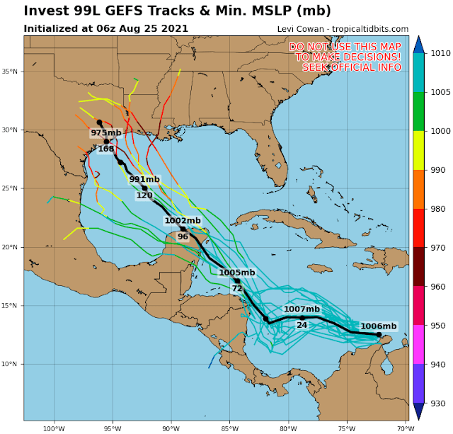
Invest 99L is currently a disorganized tropical wave hugging the northern coast of Colombia and is forecast to move into the western Caribbean on Thursday-Friday, then over the Yucatan peninsula on Saturday.


Then, there is divergence in the model guidance, with tracks as far south as Tampico and as far east as Mobile, but the heaviest clustering is currently from Corpus Christi to Lafayette. The timing for a potential landfall is looking like Monday into Tuesday.


And although the track guidance will inevitably shift around in the coming days, one thing has consistently been shown: a LOT of rain is expected.

7-day rainfall outlook (inches), valid through next Wednesday morning.

An obvious analog to this scenario is Harvey from the 2017 season. Harvey was also a disorganized easterly wave that tracked through the southern Caribbean in late August, passed over the Yucatan, then quickly developed and rapidly intensified and made landfall as a Category 4 hurricane in a matter of 2.5 days.  Then, it stalled over eastern Texas for another three days and dumped up to five feet of rain.  This system is not currently expected to intensify or stall quite like that, but models do show it moving relatively slowly as it tracks inland, and some models show it strengthening to a strong hurricane over the Gulf of Mexico.

Since a landfall is possibly just five days away, people in that section of the Gulf coast should be on high alert right now.


23 August 2021

A welcome late-August pause in activity

Track map of Atlantic tropical cyclones through August 23. The peak wind and minimum pressure for each are listed in the upper-right corner.

Grace made landfall in Mexico as a Category 3 hurricane on Saturday, Henri made landfall in Rhode Island on Sunday as a tropical storm, and there are just a couple of long-range areas of interest to watch for development. This seems like a good time to summarize where the season stands.

Grace ended up dissipating over the mountains of Mexico, and then reformed on the East Pacific side, earning a new name: Marty.  If it had maintained at least tropical depression status, it would have kept the name Grace.  Grace was the season's first major hurricane, and first case of rapid intensification (which unfortunately occurred just prior to making landfall).

Henri was the season's third hurricane, but it weakened to a tropical storm just before landfall in Rhode Island.  Although the storm surge was not as bad as feared, Henri produced (and still is producing!) a lot of rain in the northeast.  Flood watches and warnings are still in effect in several states in the northeast.

Three-day rainfall estimates, valid from Friday morning through Monday morning.

This 2-day radar loop covers Henri from hurricane status to landfall to weakening and drifting around.

This and other radar loops are available at http://bmcnoldy.rsmas.miami.edu/tropics/radar/

Through August 23rd, the season's total Accumulated Cyclone Energy (ACE) is at 171% of the average value over the past fifty years. It's 1.2x what 2020 was on August 23rd, and it's the highest since 2008 at this point in the season.  This time of year is climatologically very active, so every day without a named storm, the 2021 line will get closer to "average" -- it will reach average on September 1st if nothing else forms by then.


Now on to the next areas of interest.  There are two: one is currently over the Windward Islands and has a chance of development in the western Caribbean by the weekend, and the other is just west of Cabo Verde and has a chance of development east of Bermuda by the weekend.  As of Monday morning, the National Hurricane Center is giving both areas a 30% chance of becoming a tropical depression within the next five days.


When the time comes, the next name on the list is Ida.  Trivia tidbit: "I" storms are historically the most-frequently retired.


21 August 2021

Grace becomes season's first major hurricane, Henri upgraded to hurricane

There's a lot of activity going on just between Grace and Henri.  On Friday night, Hurricane Grace rapidly intensified right before making landfall in Mexico, reaching peak wind speeds of 125 mph (Category 3 hurricane)... the peak winds were just 70 mph (tropical storm) one day prior. That makes Grace the first major hurricane of the season. Then on Saturday morning, Henri finally became the season's third hurricane.

But before digging in to the storms, let's put both of those events in context.  The average date of the third hurricane formation is September 7th, and the average date of the first major hurricane formation is September 1st.  The ACE (Accumulated Cyclone Energy) is now at an impressive 181% of average for the date, well ahead of 2020's pace. The last year to top this level of activity by August 21st was way back in 2008.


I'll start with Grace since it will be brief. There was always a decent chance of rapid intensification (RI) with Grace, either before reaching the Yucatan peninsula or afterward in the Bay of Campeche. It waited until the very last possible moment to do it. RI can be defined several ways, but the conventional threshold is an intensity increase of at least 35 mph in a 24 hour period.  Grace easily reached that with a 55 mph increase in a day. Now that it made landfall, it's rapidly weakening, already down to a minimal tropical storm.  If it survives intact and reforms in the East Pacific, it will maintain the name Grace.


Now on to Henri.  This is going to be a significant storm for the northeast, perhaps the most impactful in three decades since Hurricane Bob left imprints on the area's memory in 1991.  There are hurricane warnings in effect for Long Island and Rhode Island and Connecticut for the first time in a decade (hurricane warnings were issued ahead of Irene in 2011, though it weakened to a tropical storm before reaching there).  There will be coastal flooding from storm surge, inland flooding from rainfall, and lots of wind-related destruction and power outages across several states.

I will simply share some of the great products from the National Hurricane Center, starting with the track forecast and wind-related watches and warnings (left), and the probability of tropical storm force winds and their most likely arrival times (right). Notice that landfall is expected sometime on Sunday evening in the Long Island area, but damaging conditions should begin about half a day ahead of that. Such widespread strong winds will be devastating to trees, resulting in power outages, blocked roads,  and crushed properties.


Storm surge will absolutely be a problem along hundreds of miles of coastline. As of now, peak surges are forecasted to be in the 3-5 feet ballpark.  But, this brings me to storm tide, the sum of the regular astronomical tide and the storm surge.  In October 2012, Sandy made landfall right at high tide, on a full moon... that exceptionally poor timing added about 3.3 feet to the resulting water levels. Henri will make landfall in the 6-8pm timeframe on Sunday, and several stations in the area have their high tide right around then too.


And finally, as people who remember Irene in 2011 can vouch for, heavy rain is a significant hazard that will also affect several states.  Widespread areas could see 3-6 inches of rain, and isolated locations could see up to 10 inches.  Rather than showing a map of forecast rainfall amounts, the map below is the flash flood risk over the next three days.  This takes into account the expected rainfall, rainfall intensity, and existing ground conditions (i.e. Fred's recent heavy rain matters for flash flood potential).


You can find the most recent version of all of these maps and more at the NHC website for Henri: https://www.nhc.noaa.gov/graphics_at3.shtml?start#contents, and if you live in an area at risk, you can consult the forecast for your specific location at WEATHER.GOV and enter your zip code in the upper-left text box.

20 August 2021

Henri poses major threat to northeast US and Grace set to make final landfall

Since my previous update on Wednesday, Grace made landfall on the Yucatan Peninsula as expected, weakened to a tropical storm, then regained hurricane intensity over the Bay of Campeche on Friday morning. Henri is centered east of northern Florida but is forecast to make a right turn and head toward New England.


Grace is a Category 1 hurricane again, and will make a second landfall on Mexico later tonight.  It is likely to strengthen more over the very warm water and in minimal wind shear, but time is running out for it.  *IF* if maintains at least tropical depression status across Mexico and reforms in the East Pacific, it would keep the name Grace; but if it dissipates and then reforms, it would take the next name in the East Pacific list: Marty.


Henri is very close to becoming the season's third hurricane, which would be 19 days ahead of average if it happens today (other years in recent memory with three hurricanes by August 20 are 2012, 2005, 2004, 2003, 1996, 1995...).  And while it has been facing moderately strong northerly wind shear, that shear is expected to relax starting today which would allow the anticipated strengthening to commence.


The large-scale steering pattern changes today as well, and Henri will start traveling north rather than west, and that is a really big problem for the mid-Atlantic and New England coasts over the next 2-3 days.  Hurricane watches and storm surge watches are already in effect for much of the area from Long Island to Cape Cod. Keep in mind that the "cone of uncertainty" is constructed using the past five years of track errors and is designed to include the track of the storm 2/3 of the time... and it does NOT show where impacts will be experienced.


One of the hazards that will affect several states is storm surge and the resulting coastal flooding.  It seems inevitable at this point that areas from Maryland to Maine will see elevated water levels and heavy surf, with the worst expected on Sunday from Long Island to Cape Cod. Henri does not even need to make landfall to generate this, as strong onshore winds will impact the area regardless.


There is a relatively small list of sixteen hurricanes that made landfall from Long Island to Cape Cod since 1851, and they are all infamous in the area: Bob 1991, Gloria 1985, Belle 1976, Donna 1960, Edna 1954, Carol 1954, etc. Even the most recent was three decades ago though.

Tracks of the 16 hurricanes to make landfall from Long Island NY to Cape Cod MA since 1851.

In terms of ACE (Accumulated Cyclone Energy), and with one advisory remaining, the season is at 154% of the average of the past 50 years. The 2021 season has been above average since it began on June 1.


18 August 2021

Grace is season's 2nd hurricane, Henri almost there too

The tropical Atlantic remains active with two named storms, Grace and Henri.


On Wednesday morning, NOAA and the Air Force had aircraft flying through Grace, and found it had reached hurricane intensity, making it the season's second hurricane (Elsa was the first, way back on July 2).  It just passed over the Cayman Islands and will reach the Yucatan Peninsula by early Thursday morning.  The forecast is confidently for it to continue the westward track and make a second landfall on Mexico on Friday night.


As I pointed out previously, the ocean heat content (an integrated measure of the ocean's temperature, not just the surface) is extremely high over the western Caribbean, so Grace will access that today.  Then, land interaction with the Yucatan will weaken it, and the ocean heat content is still high in the southern Gulf of Mexico, but not nearly as high. However, the surface temperature is very high and will be plenty to fuel reintensification.

Current map of ocean heat content (left) and sea surface temperature (right).  Daily images always available at http://bmcnoldy.rsmas.miami.edu/tropics/sectors/.

Moving on to Henri, it is approaching hurricane intensity, and is also starting to look a little more problematic for the northeast U.S. in the coming days.  It's making a slow loop around Bermuda, but by the time it's on the west side of the island, it could also be much stronger, and much closer, to the New England region.


In terms of model guidance, there is reason for some concern in the Sunday-Monday timeframe.  The GFS ensemble has had consistency in showing some members not only getting close to the U.S. coast, but actually making landfall as a hurricane. Other deterministic dynamical models have also shown this, so it should be taken seriously -- it's only 4-5 days out.


Looking further east, there is some model guidance indicating that a wave just exiting western Africa could develop in the coming 5-7 days.  The next name on the list is Ida. (Ida was introduced to the list in 2009, after Isabel was retired from the 2003 season).

 
With Grace now a hurricane, that is 8 days ahead of the average date of second hurricane formation, which is August 26th.


17 August 2021

Fred hits Florida, Grace strengthens, Henri forms

Infrared satellite image from Tuesday morning with the forecast track and "cones of uncertainty" for Fred (blue), Grace (red), and Henri (green).

Tropical Storm Fred intensified prior to making landfall on the Florida Panhandle east of Panama City on Monday afternoon, but only up to a mid-range tropical storm... fortunately it wasn't worse because that's right about where Category 5 Hurricane Michael hit in 2018. It is now tracking inland, centered over Georgia, but will bring rain from that area up into PA and NY by later in the week.

Radar animation of Tropical Storm Fred making its third and final landfall... just east of Panama City, FL. This and other loops are available at http://bmcnoldy.rsmas.miami.edu/tropics/radar/.

Grace tracked just barely south of Hispaniola as a disorganized tropical depression, but keeping its center over very warm water. It's now about to pass over Jamaica and has regained tropical storm intensity for the first time since Sunday morning. As of Tuesday morning, Grace was centered between Jamaica and the tip of Haiti's Tiburon Peninsula with peak sustained winds of 45 mph. Strong thunderstorms are bubbling around the center and it looks poised to intensify.


The ocean ahead of it is extremely favorable for tropical cyclones -- very deep and very warm water (high values of Ocean Heat Content) from Grace's current position over to the Yucatan Peninsula. This, combined with fairly low vertical wind shear, could allow Grace to become the season's second hurricane in the next couple of days.


There is a hurricane watch in effect for the northeastern tip of the Yucatan Peninsula, along with the tropical storm watches and warnings in Haiti, Jamaica, Cuba, and the Cayman Islands. Grace will weaken once over the Yucatan Peninsula on Thursday, but will very likely re-intensify over the southern Gulf of Mexico on Friday. 


And finally, Tropical Storm Henri formed near Bermuda on Monday, becoming the season's eighth named storm... yes,it's Henri the 8th.  In the reliable satellite era of the past 55 years or so, only two other seasons had the 8th named storm form so early: 2020 and 2005, so this is exceptional. Henri is forecast to make a loop around Bermuda over the next several days, but not strengthen much.


Elsewhere, the basin is quiet, but when the time comes, the next name on the list is Ida.