30 November 2019

The 2019 Atlantic Hurricane Season comes to an end


Another hurricane season is in the books... and while the official season is six months long, the climatologically most active period can be narrowed down to a third of that: mid-August through mid-October.  This was year no exception to that, as 89% of the season's ACE was racked up during those two months.  The season ended with 18 named storms, 6 of which became hurricanes, and 3 of which became major hurricanes (Category 3+ on the Saffir-Simpson scale).

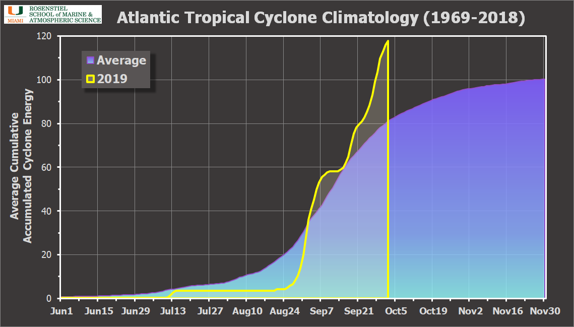
In terms of ACE (Accumulated Cyclone Energy), the season ended up at 129% of the average over the past fifty years.  Two storms, Dorian and Lorenzo, contributed an impressive 61% of the tally.


The season was dominated by a lot of weak, short-lived storms.  8 of the 18 named storms were of at least tropical storm intensity for two days or less!  The most destructive among them was Imelda, which was named for just six hours as it impacted parts of eastern Texas with nearly four feet of rain. Remember, "there's more to the story than the category!"

For the fifth year in a row, a pre-season storm jump-started things. Andrea was a subtropical storm that formed on May 20th and dissipated on the 21st.

By far, the most infamous storm of the season was Dorian, which stalled over the northern Bahamas as a Category 5 hurricane for nearly two days and gave south Florida a good scare as the monster storm refused to leave the area (see "The Unimaginable").

Hurricane Dorian on September 1, as it made landfall on Marsh Harbour. (CIRA/RAMMB)
It was the strongest hurricane to have ever impacted the Bahamas and tied the record for strongest hurricane landfall anywhere in the Atlantic (the 1935 Labor Day Hurricane was the other). It ended up following the curve of the southeast US coastline -- while the strongest winds remained offshore, significant impacts were still felt in Florida, Georgia, South Carolina, and North Carolina (but not Alabama).

I have the full-sized version of this radar loop and many others from Dorian at http://bmcnoldy.rsmas.miami.edu/tropics/radar/index.html#dorian19

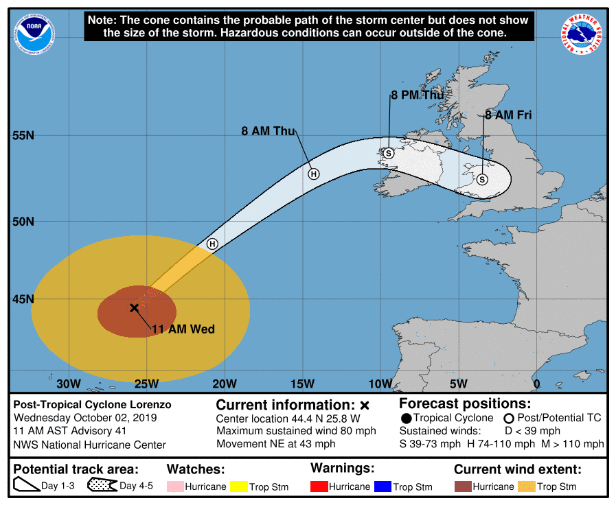
Then later that month, Lorenzo became the easternmost Category 5 hurricane.  The third major hurricane was Humberto, which passed by Bermuda as a Category 3 hurricane on September 18.

A noteworthy void of hurricane activity in the track map at the top of this post is the Caribbean Sea and Gulf of Mexico.  Only Dorian and Barry were hurricanes in those areas, and for just a few hours each.

The final storm of the season was Sebastien, which stuck around as a tropical storm for a little over five days in the central Atlantic.  The last time a season reached the "S" name was 2012: Sandy.

Since I started writing and sharing updates on tropical Atlantic activity in 1996, I've written approximately 1,250 posts spanning 381 tropical cyclones, including 177 hurricanes, 80 major hurricanes, and 44 retired storm names. Thank you for your continued interest!  Next year's list begins with Arthur, Bertha, and Cristobal, and there are no new names being introduced since none were retired in 2014.


19 November 2019

Tropical Storm Sebastien forms with 11 days left in hurricane season


The disturbance that was east of the Leeward Islands for the past 7-10 days has finally developed into the 18th named storm of the season: Sebastien.  It is not a threat to land.  The last time we reached the "S" storm in a season was 2012 (Sandy).

As I mentioned in yesterday's post, Sebastien could easily be the 9th storm this season to last for two days or less, a remarkably high percentage of weak, short-lived storms.  With nearby dry air and strong vertical wind shear approaching by Wednesday, it won't be a named storm for long.


While the official hurricane season starts on June 1 and ends on November 30, nature does not always obey those artificial bounds -- so while this is likely the last storm of the season, we can't say for certain just yet!

18 November 2019

Disturbance near Leeward Islands could become 18th named storm


With twelve days remaining in the official hurricane season, the Atlantic may not have run out of steam yet.  A lingering low pressure system east of the Leeward Islands is getting better organized and could become the 18th named storm of the season this week: Sebastien.  It has been sitting nearly stationary for at least a week now in an area of very weak steering flow.  By the way, the last time we reached the "S" name in a list was 2012 (Sandy).

It's still not even a Depression, and as you can see in the satellite image above, it's not looking too impressive today. However, environmental conditions are marginally favorable today through Wednesday.  All models agree on a northwestward track, then recurve to the northeast as it gets picked up by a cold front.  It will not affect any land.


It only has a brief window of opportunity to develop before strong vertical wind shear comes along on Wednesday-Thursday and it transitions to a strong extratropical low pressure system.  This also means that if it develops and earns a name, it would be the *9th* storm to be named for two days or less this season! You read that right: if this forms and dissipates shortly thereafter, half of the season's storms (9 of 18) will have been a tropical storm or hurricane for two days or less.

Here is a map of the season's activity through today... if Sebastien forms it would be near where Karen dissipated in late September.  One feature that looks quite obvious on that map is the lack of activity in the Caribbean Sea and Gulf of Mexico.  Only Barry and Dorian were hurricanes in those two regions, and for a combined total of just a few hours, and both as Category 1 hurricanes.


18 October 2019

Gulf storm strengthening but disorganized... impacts beginning along coast

Rainfall from Potential Tropical Cyclone 16 is reaching Louisiana over to the northern Florida peninsula as of Friday morning.  This will continue and become more widespread, and storm surge will also begin to increase for places to the right of the storm's track (with onshore wind).  Although it narrowly lacks the organization to be classified as a tropical or subtropical cyclone and earn a name, it now has peak sustained winds of 60 mph.  If it does get named, it would be Nestor.


As anticipated, it is looking less tropical and more subtropical with time, which doesn't really change the impacts, just the formal classification if it ever gets that far.  The center is still expected to reach the coastline near Panama City early Saturday morning with tropical storm force winds.  This is the same area where Category 5 Hurricane Michael made landfall last October and the long road to recovery has just begun.


Looking at the winds, the map below shows the probability of an area experiencing tropical storm strength winds over the coming three days along with the most likely arrival time of those winds.  Note that the whole southeast U.S. coast from central Florida up to North Carolina should be preparing for some potentially damaging winds (mostly damaging to trees). 


Perhaps the biggest hazard posed by this will be storm surge, and just because of where it's headed. The Big Bend area of Florida is shaped perfectly to allow winds to bulldoze water onshore.  The rainfall could be locally problematic, but overall, the storm's relatively quick forward speed will limit the amount of rain that will fall.  As of Friday morning, it's moving toward the northeast at 22mph and that is expected to increase with time.  And to round out the big 4 hazards, there is an elevated tornado threat to the right of the forecast track.  The NWS Hurricane Threats & Impacts (HTI) graphics as of Friday morning are shown below:


If you missed this on Twitter yesterday, it's worth pointing out that this system has been "on the radar" since last Thursday, just oozing its way up from central America and very slowly trying to get organized. And even as of today, it still has not developed, but is very close.
https://twitter.com/BMcNoldy/status/1184879258071494657


17 October 2019

Gulf storm will bring rain, storm surge to northern Gulf coast on Fri-Sat

The disturbance that has been a feature of interest for one full week now is finally taking shape in the western Gulf of Mexico.  Although it is not forecast to become very strong, it will bring the threats of flooding rain and storm surge to areas from Louisiana to the northern Florida peninsula in the coming days.


Identified as "Invest 96L" for now, it could get transitioned to Potential Tropical Cyclone 16 before it forms which would facilitate tropical storm and storm surge warnings to be issued if warranted. If it does become a tropical or subtropical cyclone, the next number on deck is 16 and the next name is Nestor.

This 3-day rainfall forecast is valid through Sunday morning and highlights areas that could see some heavy rain:

Three-day rainfall forecast, from Thursday morning through Sunday morning. (NOAA/WPC)
The latest 50-member European model ensemble has some members with trackable low pressures, and they are all with wind speeds in the depression-to-storm range... and all other model guidance agrees with this type of track and limited intensity.  Although impacts will begin prior to landfall, landfall should occur early Saturday in the area between the mouth of the Mississippi River (LA) over to the Big Bend area (FL).


This intensity, track, and month, all closely resemble Tropical Storm Josephine in 1996.  It formed in the west-central Gulf, tracked toward the northeast, and made landfall in Florida's Big Bend area which is especially sensitive to storm surge.  Below is a newspaper clipping I have from October 9, 1996; it documents a 5-7 foot storm surge with no wind damage near Steinhatchee (on the coast, west of Gainesville). As a resident said, "I guess it don't have to be too bad to get bad. Things like this happen around here."

Newspaper from October 9, 1996 regarding Tropical Storm Josephine. (Reading Eagle)
Elsewhere in the basin, things are quiet, so all eyes are watching Invest 96L in the Gulf.


16 October 2019

Odds increasing of Gulf storm this weekend

Surface wind streamlines as of Wednesday morning. Two circulation centers are apparent: one on each side of the Isthmus of Tehuantepec. (earth.nullschool.net)
Since yesterday's update, the disturbance over central America has drifted into the southern Bay of Campeche.  It's still disorganized, and is really close to another disturbance on the Pacific side of the low-lying 130-mile-wide Isthmus of Tehuantepec!  This has been a feature of interest going back to last *Thursday* when it was a disorganized blob off the east coast of Nicaragua.  These things can take a long time to cook (remember watching Michael for about a week last year before it became a Depression?).  While it could end up near where Michael made landfall last October, there are zero indications that this will intensify much.


The most recent European model ensemble indicates a pretty decent chance of this developing in the coming days as it heads north to northeast. Some of the ensemble members have a trackable low pressure center near the northern Gulf coast on Saturday, but none are strong (shown here).  If this becomes a tropical storm, the next name on the list is Nestor.  Nestor was introduced to this list in 2013 after Noel '07 was retired.


As I shared yesterday, there's a short list of seven named storms that developed in the western Gulf of Mexico after October 1 since 1960.  The one that took off toward the northeast into Florida's Big Bend region was Josephine in 1996.


Tropical Depression 15, the one that was way out by Cabo Verde, has dissipated and never reached tropical storm status and so was never named.

As of today, the Atlantic has had 13 named storms, 5 of which became hurricanes, and 3 of those became major hurricanes (Category 3+).  I whipped up a seasonal tracking map through today to refresh your memories on when and where things happened.


15 October 2019

TD 15 forms by African coast, also closely watching Gulf of Mexico

Enhanced satellite image of Tropical Depression 15. (EUMETSAT)
On Monday afternoon, a very strong and late African wave developed into Tropical Depression 15, way out at 20.2°W -- just 200 miles offshore! The Cabo Verde season, in which tropical waves exit the African coast near the Cabo Verde islands, typically spans mid-August through mid-October... but by mid-October it's pretty meager. As Phil Klotzbach at CSU pointed out, this is the easternmost tropical cyclogenesis this late in the year on record.

The forecast is not very threatening to anyone though. It may never reach tropical storm status as it passes by the Cabo Verde islands then off toward the northwest where it is forecast to dissipate.


Elsewhere, a disturbance over central America has some potential for development in the Gulf of Mexico later this week.  The National Hurricane Center is giving it a 40% chance of development into at least a depression by the end of the weekend.


Global model ensembles are divided on the system developing on the west side of Mexico or the east, but the trend has been shifting eastward, favoring the Gulf.  At this point, model guidance does not suggest that it becomes anything too strong, but that can change at this long lead time. So we will just keep a very close eye on it and model trends... especially interests in the western Gulf this weekend.  The next name on the list is Nestor.


Looking back to the start of the satellite era in 1960, I could find just seven named storms that developed in the western Gulf after October 1.  The two most recent were Marco (2008) and Matthew (2004). Jerry (1989) is the one that made landfall near Galveston as a Category 1 hurricane on October 16.

Tracks of seven named storms that formed in the western Gulf after October 1 (1960-2018).
Today is also the 14th anniversary of Hurricane Wilma's formation (Tropical Depression 24 at the time).  If you missed it on Twitter, there's a thread with new and interesting graphics at https://twitter.com/BMcNoldy/status/1184106020299104261


12 October 2019

Melissa forms off northeast U.S. coast


Tropical Storm Melissa, the season's 13th named storm, began its journey over North Carolina on Monday, then left the coast on Tuesday and continued to slowly organize... it was finally upgraded to a subtropical storm on Friday morning.  However, it may only be around for another day or so. Melissa will be yet another short-lived and messy storm this year, similar to Andrea, Chantal, Erin, Fernand, and Imelda -- those five storms combined were named for less than four days!


Peak sustained winds are at 50 mph and further weakening is expected as it accelerates toward the east into higher wind shear and colder water.  There are no associated tropical storm or storm surge watches/warnings. The storm is very tiny; the tropical storm force winds extend an average of just 45 miles from the center!

The recent transition from a subtropical cyclone to a tropical cyclone is nicely illustrated in this cyclone phase space diagram. It's a bit technical, but the low starts at location A on Wednesday, it's presently at location C on Saturday, and the forecast is at location Z on Friday. In this model-based analysis of the storm's structure, we see that it began as an asymmetric warm-core system (subtropical), it migrated into the symmetric warm core realm (tropical), is currently in a near-neutral zone, and is headed for the asymmetric cold core realm (extratropical).  So, while these classifications have a bit of subjectivity to them, there is also an objective foundation on which the transition is based.

Cyclone phase space diagram for Tropical Storm Melissa. (FSU)

Elsewhere, the Atlantic basin should be quiet for the foreseeable future. But don't tune out just yet... even late October has a history of producing some infamous storms!


02 October 2019

Lorenzo's trip to Ireland


Large and powerful Lorenzo has just passed the Azores and is headed toward Ireland.  It still has peak sustained winds of 80 mph and is racing toward the northeast at 43 mph. Tropical storm force winds extend as far as 390 miles from the center, while hurricane force winds extend as far as 150 miles from the center.

It will undoubtedly be a major problem in Ireland, with destructive winds and significant storm surge.  Port cities such as Galway will experience severe flooding on Thursday. Tropical storm force winds should arrive in Ireland on Thursday morning, followed quickly by hurricane force winds and a rapidly rising storm surge.  I have a long radar loop from Ireland at http://bmcnoldy.rsmas.miami.edu/tropics/radar/.


I found 18 tropical or post-tropical cyclones that passed within 100 miles of the Irish coast since 1851, and the most recent was Ophelia in October 2017, which made landfall as a post-tropical cyclone with sustained hurricane-force winds (80mph).  Debbie was the same intensity and was debateably still a hurricane when it made landfall in northwest Ireland in September 1961.  Edna was a little stronger than Ophelia and Debbie (85mph), and made landfall in northwest Ireland in September 1953 as a post-tropical cyclone.  Then the strongest on record was a post-tropical cyclone with nearly Category 2 sustained winds (90-95mph) that made landfall in southwest Ireland in September 1883.  We will see on Thursday where Lorenzo will fit into history.

Tracks of tropical and post-tropical cyclones that passed within 100 miles of Ireland since 1851. The gray lines indicate the storm was post-tropical.
Lorenzo formed back on September 23, and it alone has generated 27% of the season's total ACE (Accumulated Cyclone Energy) so far.  With this boost, the ACE is at 145% of average for this date, using the past 50 years as a climatology.


Elsewhere, the Atlantic basin remains relatively quiet for the foreseeable future.  There is a disturbance south of Cuba that has a low chance of development as it heads west toward the Yucatan Peninsula, and there's a wave still over Africa that models indicate could develop early next week in the far eastern Atlantic.

29 September 2019

Amazing Lorenzo becomes season's 2nd Category 5 hurricane

Late Saturday night, Lorenzo beat the odds and was upgraded to a Category 5 hurricane... the second of the season. The last season with two Category 5s was 2017 (Irma and Maria), and then 2007 before that (Dean and Felix).  In my previous blog post on Thursday when Lorenzo was a Category 3 hurricane, I mentioned this possibility and included the historical odds: "It will almost certainly keep going into Category 4 status, and could even reach Category 5 intensity (160+ mph) at some point.  Only about 2% of Atlantic named storms ever achieve Category 5 status".

Enhanced infrared satellite image of Hurricane Lorzeno from around the time it was upgraded to Category 5 intensity. (NOAA)
Not only did it beat the odds, it did so extremely far east; in fact, as Phil Klotzbach at Colorado State University nicely illustrated on a map, it reached Category 5 status about 600 miles further east than the previous easternmost: Hugo (1989).  I added labels to point out the three frontrunners.

Locations where all known Category 5 hurricanes first reached that intensity. (Phil Klotzbach, CSU: https://twitter.com/philklotzbach/status/1178137123687284737)
While this seems quite far north to have such an intense hurricane, the ocean temperatures in that area are normally quite warm this time of the season, and this year they're even warmer.  The water under Lorenzo when it was a Category 5 hurricane is about 28°C (82.4), which is about 1°C (1.8°F) warmer than average... just enough to give it that extra jolt.

Sea surface temperatures (°C), with Lorenzo's Category 5 position marked by a black X. (NASA)
As of 5am EDT on Sunday, it has weakened just slightly to an upper-end Category 4 hurricane with 155 mph sustained winds. The large hurricane (tropical storm force winds extend an average of 205 miles from the center), is forecast to continue tracking to the north then turn northeast, which will bring it near the Azores early Wednesday.  Beyond that, it is expected to begin the transition to an extratropical cyclone, but it will remain quite strong as it heads toward the British Isles on Friday. Both areas could easily experience hurricane conditions including destructive winds and significant storm surge.


Looking back at the history of NHC intensity forecasts for Lorenzo and comparing them to the observed intensity, we can see that the first peak was fairly well-anticipated, but the second and even stronger peak was certainly not.

Elsewhere across the basin, things will remain quiet for the foreseeable future.

26 September 2019

Karen battling dry air as Lorenzo becomes season's 3rd major hurricane

In the far eastern Atlantic, Lorenzo has rapidly intensified to become the season's 3rd major hurricane (Category 3+), with peak sustained winds of 125 mph as of 6am EDT -- just yesterday morning it was at 80 mph.  It will almost certainly keep going into Category 4 status, and could even reach Category 5 intensity (160+ mph) at some point.  Only about 2% of Atlantic named storms ever achieve Category 5 status, so don't hold your breath.

By the way, curious about other percentages? Of all 1637 known named storms (subtropical storms, tropical storms, and hurricanes) in the Atlantic from 1851 to 2019 so far:
  - 58% become Category 1 hurricanes
  - 20% become Category 3 hurricanes
  - 2% become Category 5 hurricanes
The forecast continues to confidently include a turn to the north beginning tonight which will keep this large and very intense hurricane far from land.  The exception to that could be the Azores... Hurricane Lorenzo has a chance to pass near or even over the Azores next Wednesday-Thursday.

Karen is now a minimal tropical storm.  Dry air has taken its toll on the tiny storm, and even after a slight resurgence in thunderstorm activity overnight, its days appear to be numbered.


The forecast from NHC still shows a northward motion through Friday morning, followed by a turn and/or loop toward the west, but continuing to weaken the whole time.  It could dissipate by the end of the weekend.  There is no model guidance that shows any threat to the Bahamas or the U.S. now.

Elsewhere, the basin is quiet, and no new development is expected in the foreseeable future.


25 September 2019

Karen moving away from Puerto Rico, Lorenzo upgraded to 5th hurricane


Karen made landfall on the eastern side of Puerto Rico on Tuesday afternoon as a tropical storm and is now centered about 240 miles north of the island.  As of 11am EDT, the peak sustained winds are 45 mph and it is moving toward the north at 15 mph. The northward motion is expected to continue roughly through Friday, at which point things get messy.


The NHC forecast is in line with most of the model guidance, and shows a stall sometime around Friday, followed by a sharp left turn (there could easily be a little loop in the process) toward the west. That stall-and-turn or loop-and-turn depends on a subtropical ridge building and strengthening to its north, but it also depends on how strong the storm itself is since storms of different intensities are generally steered by different layers of the atmosphere.


Models all agree on a stall and/or loop of some sort, and the large majority show some degree of westward track after that.  But what's not shown on the map above are the intensities.  In some cases, there's barely a trackable system, and there's really no support among dynamical models for anything of hurricane intensity. Clearly, given the potential for impacts in the Bahamas and the southeast US, we'll be watching model trends very closely, but as of now, it's not a cause for concern.

Lorenzo became the season's 5th hurricane on Wednesday morning, and is fully expected to become the season's 3rd major hurricane in a few days.  It is far from land in the deep tropics west of Cabo Verde, and models all agree on a north turn to begin later this week which will keep it out in the middle of the ocean. As of Wednesday morning, the peak winds are 85 mph and the official forecast brings it up to 125 mph (Category 3) by Friday evening.


Tropical Storm Jerry has been transitioned to a post-tropical cyclone, but is still headed toward Bermuda.  It is nearly devoid of rain and thunderstorms, but does have tropical storm force winds associated with it.  It will make its closest approach to Bermuda late Wednesday night. If any rain showers or thunderstorms develop in it, there are radar loops at http://bmcnoldy.rsmas.miami.edu/tropics/radar/. Recall that Jerry formed last Tuesday and peaked as a Category 2 hurricane northeast of the Leeward Islands.