30 November 2020

The record-smashing 2020 Hurricane Season ends today

The 2020 Atlantic hurricane season officially ends today, and it has certainly been one for the record books.  As of today, there were 30 named storms, 13 of which became hurricanes, and 6 of those became major hurricanes (Category 3+ on the Saffir-Simpson Scale).  For context, the average of those same quantities over the past fifty years is 12.2, 6.3, and 2.5.

This also marks the end of my 25th year writing these updates on tropical Atlantic activity.  During that time, I have written approximately 1305 posts spanning 412 tropical cyclones, 190 hurricanes, 86 major hurricanes, and close to 50 retired storm names (2019 and 2020 TBD). I was honored to have been invited to write for the New York Times hurricane blog for four years, and then for the Washington Post's Capital Weather Gang from to 2012 to present.


The previous record number of named storms was 28, set in 2005.  And not only did 2020 beat that record, it did so quickly.  With the exception of the 1st, 2nd, and 4th storms, the remaining 27 were all the earliest formation dates on record! 

A common metric used to describe overall activity is the Accumulated Cyclone Energy, or ACE.  It is independent of the number of storms and their tracks, but essentially measures a cumulative intensity and duration of all storms.  14 of the 30 named storms were around for three days or less, and coincidentally 14 of the 30 never got stronger than a mid-range (50-knot) tropical storm.  So despite the large number of named storms, 17 of them were fairly short-lived and/or weak -- a handicap for generating a lot of ACE.  The 2020 season is in 10th place in terms of ACE, and is at 178% of an average season.


For the sixth year in a row, there was pre-season activity. 2020 came out of the gate strong, with Arthur and Bertha forming during May. Then Cristobal formed on the first day of the official season and it never let up after that.  A record ten named storms formed during September.  The regular list of 21 names was exhausted by mid-September, and the Greek alphabet was utilized for only the second time ever... beginning with Alpha on September 18 (which strangely enough was Portugal's first named storm landfall).  As of today, nine letters of the Greek alphabet have been used.

Two things stand out to me in that track map at the beginning of the post. The first is that only one hurricane (Teddy) existed in the tropics between the central Caribbean and Africa. That is not a trait we tend to think of with very active seasons.  The second is the high concentration of tracks in the western Caribbean and Gulf of Mexico.  I'm not exactly sure what caused this pattern, but some large-scale atmospheric/oceanic forcing was at work.  I don't think the weak La Nina alone explains this. Unfortunately, storms in the western Caribbean Sea and Gulf of Mexico almost always make landfall... there's no way out.

A record-breaking twelve named storms made landfall in the contiguous U.S., easily surpassing the previous record of nine set in 1916. Five of those twelve hit Louisiana alone, and three of those five were hurricanes (Laura, Delta, and Zeta). The Yucatan peninsula had three landfalls, including two hurricanes (Delta and Zeta), and then there's Nicaragua. Two Category 4 hurricanes made landfall at the same location (technically seven miles apart) just two weeks apart: Eta and Iota. Iota, a mid-November storm, became the season's strongest storm, rapidly intensifying to reach Category 5 status.  Not only was it the season's only Category 5 hurricane, it made 2020 the fifth consecutive year to have a Category 5 hurricane. November 2020 was the only November to have two major hurricanes.

Tracks of the landfalling tropical storms and hurricanes in the western Caribbean Sea and Gulf of Mexico during 2020.

Although the final reanalysis of the season won't be completed for a few more months, the preliminary track and intensity verification of forecasts made by the National Hurricane Center are shown below.  To arrive at these, all 24-hour forecasts are evaluated against all observed values at that time, and so on out to 120 hours.  The average error over the prior five seasons is included for reference. Overall, track forecasts were extremely close to the average out to four days, then slightly higher at five days (Paulette was a big reason for that drift at five days). Intensity forecasts were near-average out to two days then better than average for three, four, and five-day forecasts.


Of course, the bounds of the official hurricane season (June 1 through November 30) are arbitrary, and nature could still throw in more storms during December.  Years with post-season storms include 2013, 2007, 2005, 2003, 1984, 1975, etc. so it's certainly not unheard of; in fact, there have been sixteen known named storms to form during December since 1851, five of which became hurricanes.  The next two names would be Kappa and Lambda. Otherwise, the 2021 regular list will kick off with Ana and Bill.

Tracks of the 16 known storms that became tropical storms or hurricanes during December since 1851.

17 November 2020

Iota becomes Category 5 hurricane before landfall in Nicaragua

Enhanced satellite image of Hurricane Iota as it made landfall in Nicaragua on 17 November 0400 UTC.

From bad to worse... Category 4 Hurricane Eta made landfall in Nicaragua two weeks ago today, spreading catastrophic wind, flooding, and mudslides far inland through Central America. On Monday, Iota rapidly intensified to become the season's strongest hurricane, reaching Category 5 intensity just prior to making landfall in the same location as Eta. It "weakened" only slightly to a top-end Category 4 hurricane as the eye crossed the coastline early Tuesday morning. It's impossible to imagine two such hurricanes in two weeks at the same location. Iota will now dissipate over the mountainous terrain of Central America, dumping huge amounts of rain along the way. 


Iota was the only Category 5 hurricane of the 2020 season (so far), but it also claimed the title of being the latest Category 5 hurricane on record.  The one and only other candidate was in early November of 1932.  It also marks an unprecedented string of five consecutive years with Category 5 hurricanes in the Atlantic. This map below shows the tracks of the seven Category 5 hurricanes that have occurred over the past five years: Matthew (2016), Irma (2017), Maria (2017), Michael (2018), Dorian (2019), Lorenzo (2019), and Iota (2020).  Then there were ZERO from 2008-2015, then eight from 2003-2007. They definitely come in surges.


Unfortunately, there's a hint of another tropical wave right behind Iota, and there is some support for its development in the models -- the National Hurricane Center is giving it a 40% probability of forming later this week as it approaches Central America. This map shows a forecast of minimum surface pressures of trackable lows from the American GFS model ensemble on Friday, and that clustering of ensemble members near Costa Rica and Nicaragua is very troubling. Should this become a tropical storm, it would be the season's 31st and be named Kappa.


While the season continues to obliterate records for the number of named storms, the earliest formation date of the Nth named storm, and also for number of landfalls, it just now snuck into 10th place in terms of ACE (Accumulated Cyclone Energy).  ACE is a common metric used which basically accounts for overall intensity and duration, not the number of storms or where they go. The nine years that had more ACE are all very familiar to tropical cyclone enthusiasts: 1933, 1926, 2005, 1893, 1995, 2004, 2017, 1950, and 1961. It's fitting that 2020 now joins the top ten list.


15 November 2020

Hurricane Iota threatens recently-devastated Nicaragua

Since my previous update on Wednesday, the tropical wave in the Caribbean was upgraded to Tropical Depression 31 on Friday morning, then again to Tropical Storm Iota on Friday afternoon, making it the season's 30th named storm. On Sunday morning, it was upgraded to Hurricane Iota, the season's 13th hurricane.  The only other known season with 13 hurricanes was 2005 -- it ended up with 15.


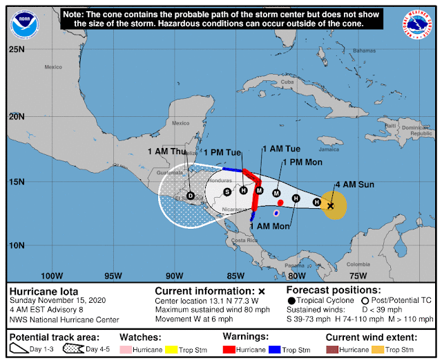
Iota is tracking toward the west, which will bring it to northern Nicaragua in a couple days. You may recall that Eta just made landfall in this same part of Nicaragua on November 3 as a Category 4 hurricane; another Category 4-5 landfall only two weeks later is just unthinkable, but that appears to be exactly the situation. The wind, the flooding rain, the storm surge... all coming back to the same places in Central America. Unlike Eta, there is no indication that Iota will turn north out of Guatemala and head back over the western Caribbean.


Also, Eta made landfall in the Big Bend area of Florida on Thursday as a tropical storm, and Tropical Depression Theta is hours away from dissipating as a low-level swirl north of the Canary Islands. There are no other features of interest on the map right now, but when the time comes (and I'm sure it will), the next name on the list is Kappa.


To call the 2020 track map crowded would be an understatement. It's literally two seasons crammed into one, and it's not over yet.  While the official season spans June 1 through November 30, these hyper-active seasons tend to ooze out of those artificial start and end bounds.

11 November 2020

Eta a hurricane again, Theta forms, Iota on the horizon

No, it's not September 11, it's November 11 and we are watching a hurricane in the Gulf of Mexico, a tropical storm out by the Azores, and a potent tropical wave in the Caribbean.  This is not normal.

First, after a stall by the western tip of Cuba, Eta began moving north and has regained hurricane intensity just west of Fort Myers, FL.  It is forecast to start a turn toward the northeast which will bring in to landfall north of Tampa, FL on Thursday.  Although it's been ingesting huge amounts of dry air into its circulation from the west, the low wind shear and warm water below it are enough to not just keep it going, but to allow it to intensify!


As such, hurricane watches are in effect for a portion of western Florida, along with storm surge warnings (check https://www.nhc.noaa.gov/graphics_at4.shtml?start#contents for the latest). Tampa Bay could see at least a 3-5-foot storm surge from this when it makes landfall on Thursday and the area could see up to a half foot of rain. If we rewind back to the beginning, the storm that is now Eta left the African coast as a tropical wave back on October 24th!! What a long strange trip it's been.


The strong low pressure system that was located southwest of the Azores was upgraded to Subtropical Storm Theta on Monday night, making it the season's record-breaking 29th named storm. It has since transitioned to a tropical cyclone and is forecast to slide between the Azores and the Canary Islands this weekend as a tropical storm.


And the wave in the Caribbean is still a feature of great interest -- NHC is giving it an 80% probability of developing into a tropical cyclone by the end of the weekend. This is quite unusual to be watching a vigorous tropical wave in the Caribbean in NOVEMBER. Unfortunately, it's on a trajectory that would take it near where Category 4 Hurricane Eta just made landfall a week ago.


If this does in fact develop and become a tropical storm, it would be named Iota and would be the season's 30th named storm.  If it becomes a hurricane, it would be the season's 13th hurricane. Only one other season in known history had 13+ hurricanes, and that was 2005 (it had 15).

09 November 2020

Eta brushes by Florida, now watching for Theta and Iota this week

After crossing over central Cuba, Tropical Storm Eta made the anticipated west turn and brushed by south Florida late Sunday night.  The center made landfall in the middle Keys, but the storm's large wind and rain shield extended far to the north. And just to keep the season going at record-crushing pace, there are TWO other features of interest in the Atlantic right now; the next two names on the list are Theta and Iota and they'd be the 29th and 30th named storms of the season.


Regarding Eta, the two-panel image below shows the approximate size of the tropical storm wind field as it crossed the Keys and the estimated two-day rainfall totals over south Florida.


The storm is poorly organized now and is centered just north of the western tip of Cuba. Its future is amazingly uncertain as its about to enter an area of weak steering currents. Depending on what subtle features nudges it next, it could go northeast toward Florida, nowhere, north toward the central Gulf coast, or southwest toward the Yucatan! The official NHC forecast opts for something slow and north, but be alert for changes as the days go by. It appears very unlikely that it will regain hurricane intensity in the Gulf.


Shifting our attention way east to near the Azores, a well-developed low pressure system could acquire subtropical or even tropical chatacteristics in the coming day or two.  If it does, it would earn the name Theta, the eighth letter of the Greek alphabet. Regardless of development, it's forecast to pass south of the Azores on Thursday-Friday.


Finally, there's a late-season tropical wave near the Lesser Antilles that the National Hurricane Center is giving a 50% probability of becoming a tropical cyclone later this week. There's not tremendous model support for this, but among the ones that do develop it, they track it westward into Central America in about a week -- unfortunately right where Eta just made landfall as a Category 4 hurricane. Should this also become a tropical storm, it would be named Iota (assuming the one near the Azores becomes Theta).


08 November 2020

Eta has crossed Cuba, hurricane conditions possible in south Florida tonight

So far, forecasts of Eta's evolution over the western Caribbean and into Cuba have been very good. The center crossed over central Cuba on Sunday morning, and it's back over water -- roughly 220 miles south-southeast of Miami as of 10am on Sunday.  It has intensified to a strong tropical storm, and it's forecast to attain Category 1 hurricane status as it passes between Florida and Cuba.


Tropical storm warnings, storm surge warnings, flood warnings, and/or hurricane warnings are plastered over south Florida, the western Bahamas, and Cuba.  Eta's wind field is asymmetric, with the bulk of the wind and rain displaced to the east and north of the center. As it turns toward the west during Sunday, the area of tropical storm force winds will extend far to the north (as indicated by the tropical storm warnings outlined in blue on the map below).

All of south Florida is also under a hurricane watch (the pink outline), meaning that hurricane conditions are possible... the extreme southern tip of Florida is under a hurricane warning, meaning that hurricane conditions are expected. I have several long and updating radar loops of Eta available at http://bmcnoldy.rsmas.miami.edu/tropics/radar/


In south Florida, the strongest winds will occur on Sunday evening into Monday morning, with gusts in the 50-70 mph range (stronger in the Keys) -- quite capable of causing significant damage to trees. Along with the wind, several inches of rain on top of already-saturated ground will result in widespread flooding.


The four hazards associated with tropical cyclones are summarized in this "Hurricane Threats and Impacts" graphic for south Florida (which has been produced routinely for every tropical cyclone affecting the U.S. since 2015). 


Beyond Monday, the storm will continue to become more asymmetric (losing its purely tropical cyclone characteristics and look) and very gradually turn back in toward Florida throughout the week. This lingering feature in its substantial envelope of moisture will keep rain chances up in the entire region.  It's not expected to become a strong hurricane in the eastern Gulf of Mexico -- one advantage of a November storm!

The last time south Florida had a tropical storm encounter during November was in 1998... Mitch passed over the area on November 5th.

06 November 2020

With Eta back over water, threat to Cuba and Florida increases

Tropical Depression Eta has re-emerged over the very warm water of the western Caribbean and is fully expected to strengthen back to a tropical storm later today.  It's centered about 60 miles east of Belize and 120 miles north of Honduras. The bulk of the thunderstorm activity associated with it is displaced to the east of the center as of this writing and satellite image below.


Model guidance continues to show the storm tracking northeast toward Cuba, reaching the island on Saturday-Sunday. Beyond that, some impact in south Florida is basically inevitable on Sunday-Monday. The hazards definitely include heavy rain with widespread flooding, and could include sustained tropical storm force winds (even a slim shot at hurricane force winds). Always check https://www.nhc.noaa.gov/graphics_at4.shtml?start#contents for the most recent information.

In this map, track forecasts from several dynamical models, ensemble means, consensus, and the NHC are shown. Keep in mind that these evolve with each new run, and that these are only the center lines of the track... impacts extend quite far from the center.


Tropical storm force winds could arrive in south Florida by Sunday evening, even if the center of the storm remains well south -- it is a large circulation and the stronger portion of it will the northern half. At this point, given the normal uncertainty in intensity forecasts 2-3 days in advance, a low-end hurricane cannot be ruled out in south Florida either.  For perspective, Irma in September 2017 produced "only" upper-end tropical storm conditions in the urban corridor of southeast Florida.


Beyond Monday, Eta is forecast to enter the Gulf of Mexico where environmental conditions are unlikely to nurture intensification, but given the large number of tropical cyclone landfalls along the Gulf coast this year, this is certainly not welcome news.

The official hurricane season ends on November 30, but active years like this don't always respect that artificial bound, so stay tuned.  Elsewhere across the basin, there is no hint of new activity in the foreseeable future... but if and when the time comes, the next name on the list is Theta.

05 November 2020

Eta inland, but may have Cuba and U.S. in its future

Since Monday morning's update, Eta did indeed continue to rapidly intensify, reaching an upper-end Category 4 hurricane that slowly drifted in to make landfall in Nicaragua on Tuesday afternoon.  It has expectedly weakened significantly over the mountainous terrain of Nicaragua and Honduras and is now a very disorganized tropical depression centered over Honduras.  The question is: what happens next?!


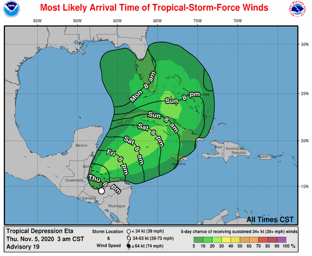
As of Thursday morning, Eta is a sprawling and struggling tropical depression... in fact, perusing some surface observations and satellite data, it's hard to even identify a surface center anymore. But there's at least a defined mid-level circulation. Whatever is left of Eta is expected to drift toward Belize in the coming day and the center should be back over warm water by Friday morning -- at which point it could start re-organizing. But will it? Probably.


A deep trough over the central U.S. will guide the storm northeast toward Cuba and then toward the Gulf of Mexico and/or Florida.  It's difficult to say anything meaningful about the intensity at that point because that all hinges on how quickly it rebuilds on Friday-Saturday. But one thing that is shaping up to look like a big threat is extremely heavy rain over Cuba and south Florida.  This 7-day forecast rainfall accumulation map (Thursday morning through next Thursday morning) shows some rather high values from West Palm Beach down to Key West! Some locations in there have already had among their wettest years on record.


Taking the latest NHC forecast as-is (there's a lot of uncertainty), tropical storm conditions *could* arrive in south Florida in the Sunday evening to early Monday morning timeframe, but heavy rain will begin well before that.  This forecast will definitely evolve, so Cuba and south Florida: pay close attention to updated forecasts at https://www.nhc.noaa.gov/graphics_at4.shtml?start#contents


Addressing the uncertainty... there's still quite a bit of spread in model guidance. Regarding south Florida, I would not rule out a slim possibility that Eta could visit as a hurricane, though a tropical storm or less is far more likely. And some models bring it north much faster, with a closest approach early Sunday; while others are slower and have a closest approach on Monday afternoon. Be prepared and alert.

These two ensemble runs from the European and American models show relatively good agreement in the next 3-4 days, then rapidly-growing spread 5-6 days out, and huge spread 7-10 days out. So don't take any long-range forecast literally; there's a lot of uncertainty!


South Florida has had just one known hurricane encounter during November, and that was November 4, 1935.  But there have been a few tropical storm encounters during November, the most recent being Mitch on November 5, 1998.

02 November 2020

Hurricane Eta rapidly strengthening before Nicaragua landfall

Since my previous update on Friday morning, the wave in the eastern Caribbean was upgraded to Tropical Depression 29 on Saturday afternoon, then to Tropical Storm Eta on Saturday night. This made it the season's 28th named storm which ties the 2005 record.  Then, on Monday morning, it was upgraded again to Hurricane Eta, the 12th hurricane of the season.  It is less than a day from making landfall on Nicaragua.
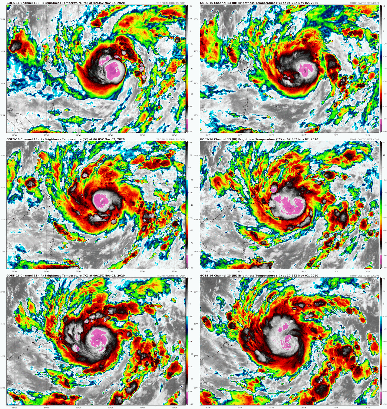

It is getting organized in a hurry now... this swath of microwave satellite data from earlier today reveals the precipitation structure under the cloud tops, and there's most definitely a compact eye and eyewall in there. It's not out of the question that this sneaks in at Category 3 intensity (it would be the season's 5th major hurricane if it does).


 Once it slams into Nicaragua tonight, it will pass over Honduras, weaken quickly over the mountainous terrain, and slow down as it loses the environmental steering currents in a few days. Aside from the immediate threats of storm surge and hurricane-force wind along the Nicaraguan and Honduran coasts, the flooding and mudslides caused by heavy rain are a major concern in the entire region. 


It's that slowing down so close to the western Caribbean powder keg that actually presents some challenging uncertainty. For the past few days, long-range global models have been indicating that Eta might not simply dissipate over Central America. It (or its remnants) could eventually get tugged northward, back over the steamy water in the western Caribbean, and toward Cuba in a week or so.

Here is what such a complicated scenario looks like at the moment. The left panel is from the 50-member European model's ensemble and the right is from the 20-member American model's ensemble. Both have tracks displayed out to 10 days where possible (240 hours). Both agree on the track into Honduras, and the slowing down. Then, the majority of members from both turn the storm north in 4-5 days, followed by a re-intensification and track toward Cuba. 


Should that happen, the door is open for it to enter the Gulf of Mexico, hit south Florida, or pass further east over the Bahamas sometime early next week. But first, we need to see if it survives its encounter with central America.

Only three prior hurricane seasons are known to have had 12 or more hurricanes: 2010, 2005, and 1969. So with a month still remaining in the official hurricane season, this is quite impressive.

30 October 2020

Eta, 28th named storm, expected to form soon

All signs point to 2020 getting its 28th named storm very soon.  Invest 96L is located in the eastern Caribbean and is a late-season wave that left the African coast back around October 24th.  But only now is it encountering an environment that's allowing it to develop.  If it becomes a tropical storm and earns a name, it would be Eta, and would tie 2005's record of 28 named storms. 


As of Friday morning, the wave is centered about 140 miles west of Grenada, or 300 miles east of Bonaire.  It is expected to track westward through the Caribbean and reach Nicaragua/Honduras sometime around Tuesday. The National Hurricane Center is giving it a 70% probability of development within the next couple of days, and models unanimously favor its development too. The red shaded area on the map below indicates the potential area in which the NHC is expecting Invest 96L to develop into a tropical cyclone (don't confuse it with the "cone of uncertainty").


While the majority of model guidance favors a tropical storm or minimal hurricane heading west, the ensembles have some notable outliers, so we shouldn't get too confident in the outcome just yet.


If it should reach hurricane intensity, it would have plenty of company, historically. November hurricanes are not that rare, especially in the western Caribbean.  For some context, this map shows the 23 known November hurricanes over the past 50 years. The list includes some infamous storms such as Paloma '08, Michelle '01, and Lenny '99. The strongest U.S. hurricane landfall during November was Kate in 1985.  The official hurricane season ends on November 30th, but storms can and have formed after that artificial bound.


28 October 2020

Zeta will be Louisiana's fifth landfalling storm this season

Hurricane Zeta is poised to make landfall in Louisiana on Wednesday afternoon.  This will be the state's fifth landfalling storm this season, its third landfalling hurricane, and the sixth along the northern Gulf coast. And there's still another month left of the official hurricane season.


As of Wednesday morning, Zeta is centered 300 miles south of New Orleans and is accelerating as well as intensifying.  It's almost a Category 2 hurricane with 90 mph peak sustained winds in the eyewall and is moving north at a brisk 17 mph.  


That forward motion will increase throughout the day, resulting in an amplified and dramatic storm surge to the right of where the center crosses the coast.  The coast of Mississippi could see a 6-9-foot storm surge, while Lake Pontchartrain by New Orleans could see a 3-5-foot storm surge.  The storm's rapid forward motion means heavy rain will be less of a problem, but still not anything to ignore (heavy rain will extend far inland across the southeast and mid-Atlantic states).

These Hurricane Threats and Impacts maps highlight the areas at risk from the four hurricane hazards: wind, storm surge, flooding rain, and tornadoes. The "cone of uncertainty" is overlaid for reference, and to show that impacts always extend far beyond the cone (it is not intended to show impacts at all).


To help illustrate the statement in the opening paragraph, here is a map of the previous five landfalling storms in the area, with Zeta's forecast track added as the thick pink line.