31 July 2020

Hurricane Isaías poised to strengthen over the Bahamas


Late Thursday, after the center had spent a few hours over the ocean north of Haiti, Isaías was upgraded to a hurricane, the second of the season.  It is expected to strengthen some more over the warm water around the Bahamas. The numerous small flat islands that comprise the Bahamas do not offer resistance to a tropical cyclone like Puerto Rico and Hispaniola do. Hurricane warnings are in effect for the Bahamas, and a tropical watch for the southeast Florida peninsula. We can expect the watches to crawl northward along the US east coast as the day goes on, and parts of southeast Florida could see their watches get upgraded to warnings.

Confidence is growing that the center of Hurricane Isaías will remain just off the east coast of Florida, but be close enough to bring wind, rain, and storm surge, particularly in the central and northern portions (where a landfall is not out of the question). There is also increasing confidence from consecutive model cycles that South Carolina or North Carolina could be looking at a hurricane landfall on Monday. Very few deterministic model runs or ensemble members keep the center of the hurricane completely offshore now. The following map shows the probability of locations experiencing tropical storm force winds within the next five days as well as the most likely arrival times of those winds.


Prior to reaching the network of U.S. radars, there will be radar coverage of it from Cuba and the Bahamas: http://bmcnoldy.rsmas.miami.edu/tropics/radar/

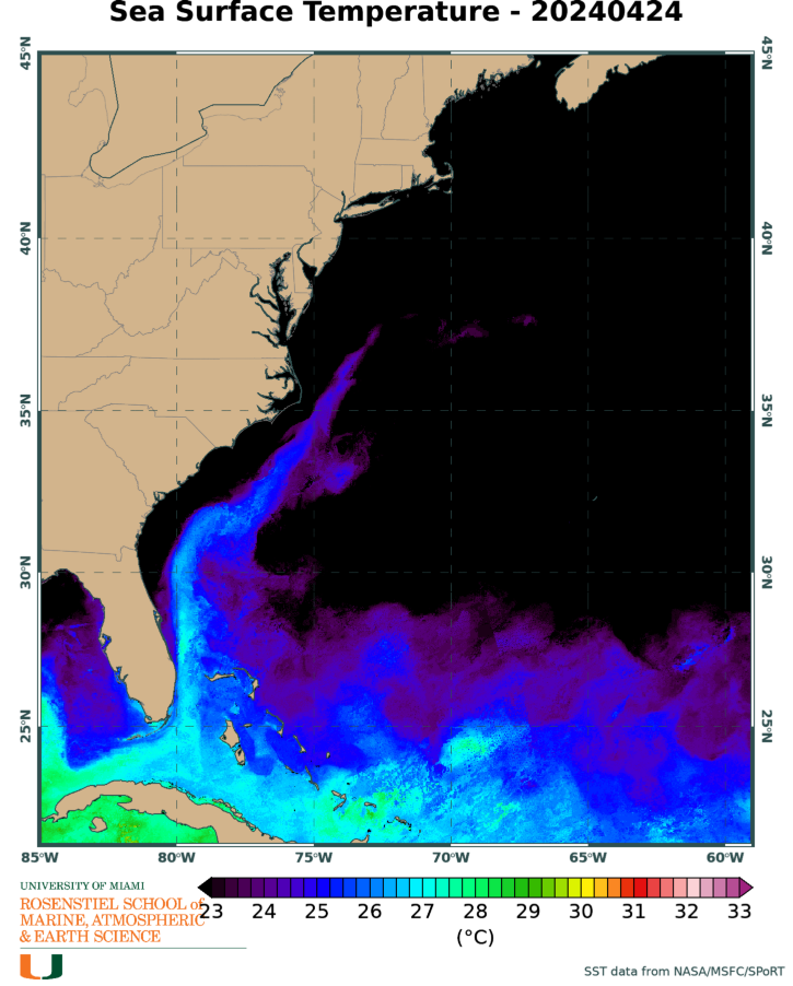
As of Friday morning, the official forecast shows Isaías reaching Category 2 intensity over the central Bahamas, then starting to weaken. There's actually not even much model support for it reaching the Category 2 mark. While the ocean temperatures are plenty warm to sustain a very strong hurricane, increasing vertical wind shear should limit how much intensification will take place, and there is a band of dry air ahead of it which could start to work its way into the circulation.

In terms of Accumulated Cyclone Energy (ACE), the 2020 season is at about 238% of average for this date, using the past fifty years as the baseline for the average.  The last season to be higher than 2020 by now was 2008 and then 2005 before that.  ACE is a commonly-used metric for tropical cyclone activity, and is calculated by adding up the squares of the intensities of every storm, every six hours -- it's a crude way of measuring the combination of intensity and duration, and is independent of the actual number of named storms.


30 July 2020

Isaías finally forms near Puerto Rico

A week after departing the African coast, the tropical wave we've been patiently watching was finally upgraded to Tropical Storm Isaías on Wednesday night.  This is the season's ninth named storm and the earliest ninth named storm on record -- the old record was set on August 7th, 2005 by Irene. So not only did it break the record by over a week, the *average* date of the ninth named storm formation (over the past fifty years) is September 26th, nearly two months from now! So, 2020 has now bumped 2005 off the record list for the earliest E, F, G, H, and I storms.


As of Thursday morning, Isaías is nearly on the shores of Hispaniola and has 60 mph peak sustained winds. Some strong rainbands have been impacting Puerto Rico resulting in flash flooding and power outages. The wind field is very large for a new tropical storm, but also very lopsided. It will undoubtedly weaken during the day as the center passes over the large mountainous island. Then it is expected to emerge over the southern Bahamas on Friday morning and have the opportunity to start re-organizing.  

Tropical storm warnings cover the Virgin Islands, Puerto Rico, Dominican Republic, Haiti, and the southern 2/3 of the Bahamas... the northern 1/3 of the Bahamas is under a tropical storm watch. A chunk of southeast Florida will likely be added to that watch list shortly. Long radar loops from Puerto Rico and the Bahamas are available at http://bmcnoldy.rsmas.miami.edu/tropics/radar/


Models are gradually coming together in showing a track that recurves toward the north over the Bahamas and scrapes the east coast of the Florida peninsula. Like Matthew four years ago, just a little wiggle makes a difference in what is experienced on land. But unlike Matthew, this isn't a Category 4 hurricane! Based on the current NHC intensity and track forecast, which are admittedly highly uncertain because of the upcoming interaction with Hispaniola, here are the most likely arrival times and probabilities of tropical storm force winds along the track.


The intensity guidance from the dynamical models has been fairly consistent with showing this becoming a strong tropical storm or Category 1 hurricane, but it's a tough call not knowing what condition it will be in by Friday morning.

The ocean temperature along the forecast track is very warm (>29°C, 0.5-1.5°C above average), including the energy-rich Gulf Stream that follows the shape of the southeast US coastline. However, a limiting factor to keep Isaías in check is vertical wind shear which is expected to ramp up beginning this weekend as a trough approaches from the west.


Since the forecast is more uncertain than usual, we need to pay extra close attention to this storm for any changes and to be prepared if it comes your way.  You can always find the latest at https://www.nhc.noaa.gov/graphics_at4.shtml?start#contents

Turning our eyes eastward, there's a weak tropical wave near 40°W that has a slight chance of developing in the coming days, but should also remain over the ocean... it's something to be aware of anyway. The next name on this year's list is Josephine.

29 July 2020

Tropical disturbance crosses into Caribbean

Potential Tropical Cyclone Nine (formerly Invest 92L) has still not developed into a tropical storm, but crossed over the Leeward Islands on Wednesday morning.  Aircraft and radar data confirmed the lack of a closed low-level circulation -- a key requirement for any tropical cyclone. It's quite close to being classified as a tropical storm though, and that could easily happen later today. If named, it would be Isaías.


The forecast beyond Thursday is extremely fuzzy with this, because 1) models don't generally handle disorganized tropical disturbances too well and 2) it will encounter Hispaniola on Thursday. This large mountainous island could be the end of something that barely got started (remember Erika in 2015?). Looking at the latest batch of ensemble tracks from the global model ensembles, we see none that reach hurricane intensity south of northern Florida. Members that stay further south and cross over more land stay very weak, while members that turn north are able to intensify more. For the south Florida concern: very few end up near south Florida, and among the ones that do, they are weak. If it were to reach south Florida though, it would be Saturday, or as late as Sunday morning.


Moving on to the suite of deterministic model runs, more of these pass south of the Bahamas and eventually travel roughly along the Florida peninsula. But, although not shown here, these are all tropical depressions or tropical storms the entire time.


And to summarize everything, I'll wrap up with the official forecast from NHC. They have the unpleasant task of making a 5-day deterministic forecast for all the world to see. The tropical storm warnings (blue) and watches (yellow) are pretty straightforward, but the track and intensity forecast from Thursday onward is in their words "more uncertain than usual". Keep in mind that the size of the cone of uncertainty is fixed for every forecast of every storm all season long, so it does not reflect actual current uncertainty. Similarly, the intensity markers (D, S, H, M for Depression, tropical Storm, Hurricane, Major hurricane) do not reflect any intensity uncertainty.


28 July 2020

Warnings issued ahead of tropical disturbance

The tropical wave I first mentioned last Thursday has still not developed into a tropical cyclone, but it's getting close. Now centered about 550 miles (1 day) east of the Leeward Islands, this disturbance is forecast to become Tropical Storm Isaías this week. (that's pronounced ee-sah-EE-ahs)


"Potential Tropical Cyclone 9" (formerly "Invest 92L") is moving quickly toward the west; tropical storm warnings have been issued for the Leeward Islands, Puerto Rico, and Dominican Republic.  Note that a "potential tropical cyclone" is the same critter as an "invest"... both are disorganized systems that are not yet tropical depressions. However, the PTC label was developed in 2017 to facilitate the issuance of watches and warnings related to a system that had not yet formed (like this one). Prior to that invention, they had to wait until something formed to be able to warn on it.

Model guidance is pretty scattered with this, so the static-sized cone doesn't adequately capture the present level of track uncertainty, and the "S" doesn't adequately capture the intensity uncertainty. The positions and intensities on Friday, Saturday, and Sunday are big question marks, so don't take them literally. A reconnaissance flight into the area is planned for Tuesday afternoon, and that will reveal some details on the structure and the data that are collected will be assimilated into the evening's suite of model runs.


One big thing working against PTC9 is a huge mass of dry air... a Saharan Air Layer surge.  It has been battling against that since it left the African coast, and it doesn't seem like it will escape it any time soon. This map shows the center of the developing storm with a red I (Invest), a background satellite image, and then the yellow-orange-red shading indicates increasing amounts of dry, dusty air.  Forecast models keep that dry air really close for the next several days.


Furthermore, if it takes a track close to or over the big islands like Puerto Rico and/or Hispaniola, that will also disrupt intensification.  If it tracks a bit north of those islands, it could get stronger. That leads to the track scenarios. The more southern tracks that pass over Puerto Rico, Hispaniola, and even Cuba show a storm that remains very weak, or even dissipates.  A nudge northward includes some land interaction, then over the Bahamas. And further north misses most land interaction but still passes over the Bahamas.

Then there's a lot of spread regarding a track that continues into Florida, one that recurves slightly up into the southeast US, or one that recurves completely before reaching the U.S. Since we don't even have a tropical cyclone yet, it's too early to have confidence in forecasts that far out.  But for timing purposes, a south Florida encounter would be on Saturday-Sunday, while a Carolinas encounter would be Monday-Tuesday.

These track maps show output from the ECMWF and GFS global model ensembles; the tracks are colored by intensity, with Category 1 hurricanes starting at yellow. In addition to these, there are several deterministic runs that are used, but I haven't shown them here yet.


26 July 2020

As Hanna makes landfall, focus shifts to east Atlantic

Hanna made landfall on Saturday afternoon at about 5pm local time on Padre Island, Texas as an upper-end Category 1 hurricane.  It continued to intensify right up until landfall, reaching peak sustained winds of 90 mph. The Corpus Christi area was in the northern eyewall (with the onshore winds) and as a result experienced the worst of the storm surge, which was about 6 feet.


Over the past two days (Friday morning through Sunday morning), preliminary rainfall estimates show a peak of about a foot near Brownsville, with scattered rain gauge data showing 8-10 inches, and a larger swath of at least 3 inches.


These storms that rapidly intensify as they're about to make landfall are a challenge, to say the least. This chart shows the 6-hourly observed intensity in the thick black line (note that these are not necessarily the intensities at the advisories), then each forecast made by the National Hurricane Center is shown in the colored lines. I added the time of landfall as a reference point.  This storm far exceeded model guidance and human forecasts.  Fortunately, it didn't have more time to work with or it certainly would have gotten even stronger.


Hanna is now a weakening tropical storm over northeast Mexico, and continues to dump rain but will lose tropical cyclone characteristics by Monday. There are a couple long radar loops covering Hanna's landfall at http://bmcnoldy.rsmas.miami.edu/tropics/radar/

Now on to the tropical wave I've been mentioning for a few days... it left the African coast on Friday and continues to show signs of gradual organization.  NHC is giving it a 60% probability of becoming a tropical cyclone within the next two days, and a 90% probability within the next five days. Models support this high likelihood.  It looks ragged on satellite images so far on Sunday, but regardless, it's on track to reach the Lesser Antilles on Wednesday-Thursday, likely as a tropical storm.


Water temperatures are very warm ahead of it and across the deep tropics, quite a bit warmer than average for this time of year (2-3°F). We think of ocean temperatures warmer than about 26°C as sufficient, 28°C as plenty warm, and 30°C+ as rocket fuel. 

http://bmcnoldy.rsmas.miami.edu/tropics/sectors/

Long-range models are trending toward keeping Invest 92L (likely future Isaias) toward the north end of the Lesser Antilles, then Puerto Rico and Hispaniola, as opposed to remaining in the deep tropical Caribbean. This latest example from the 50-member European global model ensemble illustrates the general behavior: members that remain far south tend to dissipate or remain very weak in the Caribbean, but roughly 1/3 of members pass north of Hispaniola and are able to become stronger. Among those, some turn northward more quickly and other more slowly. The "L" symbol positions on this map are valid on August 3rd. As with any long-range model product, never take it literally. The details are irrelevant, but the patterns and trends are useful.


25 July 2020

Hanna becomes first hurricane of the season as Gonzalo falls apart

As alluded to in yesterday's post, Hanna did indeed reach hurricane intensity, and with just hours remaining until landfall, it's still strengthening. As of the 15 UTC advisory, peak sustained winds are up to 80 mph.  It is moving toward the west at 7 mph, which brings it to landfall in the mid-afternoon timeframe. I have a variety of long radar loops available at http://bmcnoldy.rsmas.miami.edu/tropics/radar/


Storm surge could reach 3-5 feet north of the center (where the wind is onshore) and parts of south Texas could see rainfall totals up to 18 inches.


Over the past fifty years, the median date of the first hurricane is August 6th, so Hanna is about two weeks ahead of par (the average date is August 15th).  There's virtually no trend over this period in this date, and in the fifty years from 1971-2020, no hurricane has formed prior to the start of hurricane season (I omit Alex in January 2016 because meteorologically, it was a post-season storm of the 2015 season).

It's quite rare to get hurricane landfalls in this stretch of the Texas coast between Brownsville and Corpus Christi... the last three were in 2008 (Cat2 Dolly), 1999 (Cat3 Bret), and 1980 (Cat3 Allen).  Now we can add Hanna (Cat1 in 2020) to the list. Harvey made landfall as a Category 4 hurricane just north of Corpus Christi in 2017.

Further east, and on the other end of the spectrum, Tropical Storm Gonzalo is disintegrating as it reaches the Windward Islands. It is still officially clinging to tropical storm status, but it is hard to spot if you didn't know where to look!  It is forecast to degenerate into an open wave later this weekend off the coast of Venezuela.


Finally, Invest 92L remains a feature of interest in the far eastern Atlantic. It will be slow to get going, but there is solid agreement among models that it will develop and track through the deep tropics. It will reach the Lesser Antilles on Wednesday, and then in the 7-10-day range, the track spread naturally increases dramatically, so it's certainly something to keep an eye on. If named, it would be Isaías (ees-ah-EE-ahs).  This name was introduced in the 2014 season (Ike was retired in 2008), but never used because that season ended with Hanna.


24 July 2020

Two landfalls on Saturday, and watching far eastern Atlantic


Gonzalo is approaching the Windward Islands, and has been unable to intensify to a hurricane due to its proximity to dry and dusty air.  It's still a small storm (tropical storm force winds extend an average of about 17 miles from the center!!), and peak sustained winds are presently at 45 mph. A tropical storm warning is in effect for Barbados, St. Lucia, and St. Vincent & Grenadines.


It will cross over the Windward Islands on Saturday, then face an even more hostile environment in the central Caribbean. In fact, the NHC forecast is for it to dissipate completely within four days.  This is a rough time for tropical cyclones to take this track... we can be thankful it's not a month later!

Tropical Depression 8 was upgraded to Tropical Storm Hanna on Thursday night and it has continued to intensify.  Peak winds are up to 50 mph as of 2pm on Friday, and it's clearly getting more organized by the hour. It too will make landfall on Saturday, in the vicinity of Corpus Christi, Texas.  With minimal wind shear and toasty water temperatures, there is a very real chance that Hanna becomes a hurricane prior to landfall, though that is not in the official forecast.  I have several updating radar loops to cover the landfall, all available at http://bmcnoldy.rsmas.miami.edu/tropics/radar/


This comes with the regular suite of hazards, including wind, inland rainfall flooding, and coastal storm surge flooding.


And that wave I mentioned yesterday is still a feature to watch in the coming days.  It's six days away from reaching the Lesser Antilles (Thursday), but there is model guidance to suggest that it is likely to develop. The National Hurricane Center has also increased the probability of it developing within the next five days to 40%. Conditions ahead of it are marginal now and for the next 1-2 days, but beyond that, there appears to be little in its way. It is officially tagged as Invest 92L ("Invest" is the term given to systems of interest that are not yet tropical cyclones, 92 is part of the revolving sequence of numbers given to invests (90-99), and L is for atLantic).


The next name on the list is Isaias.  The record earliest date for the ninth named storm is August 7, so if this becomes a tropical storm within the next 13 days, it will break that record and join Cristobal, Edouard, Fay, Gonzalo, and Hanna this year!


23 July 2020

Hurricane watch for Windwards, tropical storm watch for Texas

Shortly after my post yesterday, Tropical Depression 7 was indeed upgraded to Tropical Storm Gonzalo, making it the earliest seventh named storm on record by two days. Centered about 850 miles east of the Windward Islands (the southern portion of the Lesser Antilles), it has peak sustained winds of 65 mph. It is right on the southern periphery of a Saharan Air Layer, and appears to be ingesting some of the dry and dusty air into its circulation.  It's quite anemic on satellite images today, especially compared to yesterday.


Its future is anything but certain.  Many model solutions indicate that it will dissipate completely in the Caribbean, while a few indicate a respectable Category 1-2 hurricane in the near future. There are a few reasons for the extreme differences. 1) Gonzalo is really small, so courser-resolution models struggle with that, 2) it is tracking on a knife's edge of really dry air, and 3) the exact track forecast could bring it into really strong vertical wind shear, or only moderate shear.


But, in the meantime, tropical storm force winds are expected to arrive in the Windward Islands on Saturday. A hurricane watch is in effect because of the possibility (and official forecast) that Gonzalo could be a hurricane at that point.


The disturbance in the central Gulf of Mexico was upgraded to Tropical Depression 8, and could soon be upgraded again to Tropical Storm Hanna.  The average date of 8th named storm formation is September 17th, and the record earliest is August 3rd (Harvey in 2005).  Recall that 2020 already set the record for earliest 3rd, 5th, 6th, and 7th named storm formation... why not keep going? 


It's centered south of central Louisiana and moving toward the west-northwest at 9 mph. It is expected to reach the Texas coast on Saturday morning, but heavy rain and tropical storm force winds will arrive throughout the day on Friday.  The greatest risk of flash flooding exists along the LA and TX coastline through the end of the weekend.


Much further east, a new tropical wave is just exiting the African coast today and there is some model guidance that supports it developing in a few days, but the large-scale environment is likely too hostile for the next 2-3 days.

When the time comes, the next couple of names on this year's list are Isaias (introduced in the 2014 list after Ike was retired in 2008, but 2014 only got to Hanna, so Isaias has not been used yet) and Josephine.


22 July 2020

Watching two systems in the tropics... could become Gonzalo and Hanna?

Tropical Depression 7 formed on Tuesday afternoon from an easterly wave that left the African coast back on July 15th. As of Wednesday morning, it's centered about 1250 miles east of the Windward Islands and moving toward the west-northwest at 12 mph.  It is very close to tropical storm intensity, and when that happens, it will be named Gonzalo.


If this indeed becomes a tropical storm today or tomorrow, it will be the earliest 7th named storm formation on record, beating Gert from July 24, 2005. It's also worth pointing out that this is the first tropical cyclone to develop in the deep tropics this season.

Most model guidance shows some further strengthening in the next 3-4 days, but then weakening (or even dissipating) as it enters the high wind shear environment in the Caribbean. The storm, most likely at tropical storm intensity, will reach the Windward Islands on Saturday.  The National Hurricane Center's forecast is in line with this. This product is not the cone of uncertainty, but rather, the tropical storm force wind speed probabilities and their most likely time of arrival.


Beyond that timeframe, uncertainty continues to increase, naturally. The American and European global model ensembles are in fairly good agreement on it staying in the Caribbean (and weakening), though there are a few outliers that bring it north of the Greater Antilles. These maps depict the track density from the ensemble members (50 for ECMF and 20 for GEFS). Don't focus on exact tracks from long-range ensemble forecasts, they're just useful to look for patterns and probabilities.


Elsewhere, a tropical wave in the central Gulf of Mexico has a decent shot at becoming a tropical cyclone before it reaches Texas later on Friday. If it becomes a Tropical Depression, it would be the 8th, and if it gets named, it would be Hanna.


The environment ahead of it is marginal for development, but regardless of formation, it will be a rain-maker as they all are.  This map shows the accumulated rainfall forecast through the next week.


09 July 2020

Fay becomes earliest 6th named storm on record

A low pressure system that tracked over the southeast U.S. the past few days emerged over the ocean on Wednesday, and finally gained enough organization to get upgraded to Tropical Storm Fay.  Fay is the 6th named storm of the 2020 season; it formed 12 days before the previous record-holder (Franklin on July 21, 2005) and 8 *weeks* ahead of the average 6th named storm formation.


Of course, having a bunch of named storms is one thing, but it's important to keep them in perspective. So, far, the six of them have been around for a total of 10 days, and the strongest one topped out at about 58 mph (mid-range tropical storm).  This is nothing like 2005 which already had a Category 4 hurricane and a Category 5 hurricane was in the making on this date! 

Fay is centered just 40 miles off the North Carolina coast, and has peak sustained winds of 45 mph, though those are found offshore to the east of the center.  It is moving toward the north at 7 mph and that motion is expected to continue. That will bring it to landfall near NJ/NY on Friday afternoon.  As such, tropical storm warnings have been issued for coastal NJ, NY, and CT.


In terms of timing and planning, the graphic below shows the most likely arrival time of tropical storm force winds (lines), and the probability of a location receiving those winds (shading). Coastal areas can expect elevated tides and some flooding.


The rainfall outlook for the next couple of days is shown below:


Elsewhere in the basin, no activity is expected in the foreseeable future, but the next name on this year's list is Gonzalo.