Wanda won't be affecting land in its future, but has peak sustained winds of 50 mph and is located about 1800 miles east of North Carolina and 1900 miles west of southern Portugal -- truly the middle of Atlantic! It is not forecast to reach hurricane intensity, and should transition back to an extratropical cyclone by the end of the week.
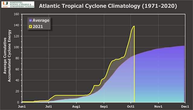
The cumulative ACE (Accumulated Cyclone Energy) is at about 143% of average for the date, and Wanda won't contribute too much more to the overall tally.
With one month remaining in the official Atlantic hurricane season, there's a chance that Wanda won't be the last. If anything should form, we'll switch over to the auxiliary list, shown below. This list was chosen to replace the use of the Greek alphabet. Only 2005 and 2020 ever exhausted the regular list of 21 names before, so to happen in two consecutive years now is extraordinary!
There is actually an easterly wave that just left the African coast, and NHC is giving it a 30% probability of becoming a tropical cyclone in the next five days. It has been tagged as Invest 95L. This would be a very late-season Cabo Verde storm should it form.


