Fiona is passing over the Turks and Caicos islands on Tuesday, while intensifying. Peak sustained winds are up to 115 mph and some additional strengthening is likely as it makes its way toward Bermuda. It is expected to pass very close to Bermuda on Thursday night, possibly as a Category 4 hurricane, then continue north and reach Nova Scotia and Newfoundland on Saturday. Even if it is no longer technically a hurricane by then, it would be a potent extratropical cyclone -- the impacts would be the same.
Tropical Depression 8 is a small and lopsided storm located about 900 miles southwest of the Azores, or 1100 miles east of Bermuda. Although conditions do favor some brief intensification to a tropical storm, it is forecast to stall and transition to an extratropical cyclone by the weekend without affecting any land. The next name on this list is Gaston.
Invest 98L, the easterly wave that exited the African coast back on September 15, is now centered about 500 miles east of Trinidad. It has not been a particularly energetic wave so far, but that is expected to change. Given its proximity to the Windward Islands and the potential for development, this could be re-classified as Potential Tropical Cyclone 9 soon, but that's still a disturbance, or Invest. If it's tagged as a PTC, then tropical storm watches/warnings could be issued ahead of it before it forms.
It will hug the northern coast of South America for the next few days, gradually gaining latitude as it moves west. By Saturday into Sunday, models are in strong agreement on it being south of Haiti or Jamaica, but the intensity is a much bigger question mark. Some ensemble members barely develop it at all by then, while others have a hurricane.
After that, uncertainty naturally increases, and there's a broad spread in ensemble-based track scenarios... ranging from Nicaragua to eastern Cuba or even further east. It's always important not to focus on any specific model or any specific cycle, but rather, look for consistency and trends. These plots below show forecasts from the European model ensemble (left) and the American model ensemble (right); the thick black line is simply the ensemble mean.
The environment ahead of 98L looks to be quite favorable for development as we head into the weekend. At this point, the best one can say is that a lot of people need to be paying close attention to this because it's not leaving the Caribbean without hitting somewhere. If you're in the Yucatan, Jamaica, Cuba, Florida, or the US Gulf coast, don't tune this out. Assuming TD8 becomes Gaston, this system would take the next name, Hermine (pronounced her-MEEN). By the way, at this point in 2020, we were already one storm name into the Greek alphabet!
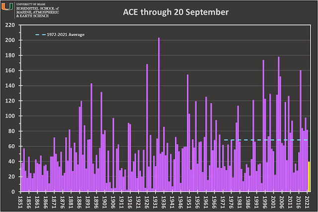
In terms of ACE (Accumulated Cyclone Energy), the season is at roughly 58% of the average value for this date, using the past fifty years as the baseline. Of course, there is plenty of room left in the season for some significant hurricanes, so even a "slow" season doesn't mean we can let our guard down.


No comments:
Post a Comment