

Tropical Storm Fiona crossed into the Caribbean Sea on Saturday and is centered just south of St. Croix as of Saturday afternoon. A hurricane warning has been issued for Puerto Rico and a hurricane watch for eastern Dominican Republic. If the fragile inner core manages to avoid passing directly over Puerto Rico and Hispaniola, it could intensify more rapidly than previously expected. The ocean temperature is plenty warm in that area, and the vertical wind shear has decreased a bit today as expected. Fiona was quick to take advantage of the slight change in environmental conditions.


You can find the latest version of this radar loop at http://bmcnoldy.rsmas.miami.edu/tropics/radar/
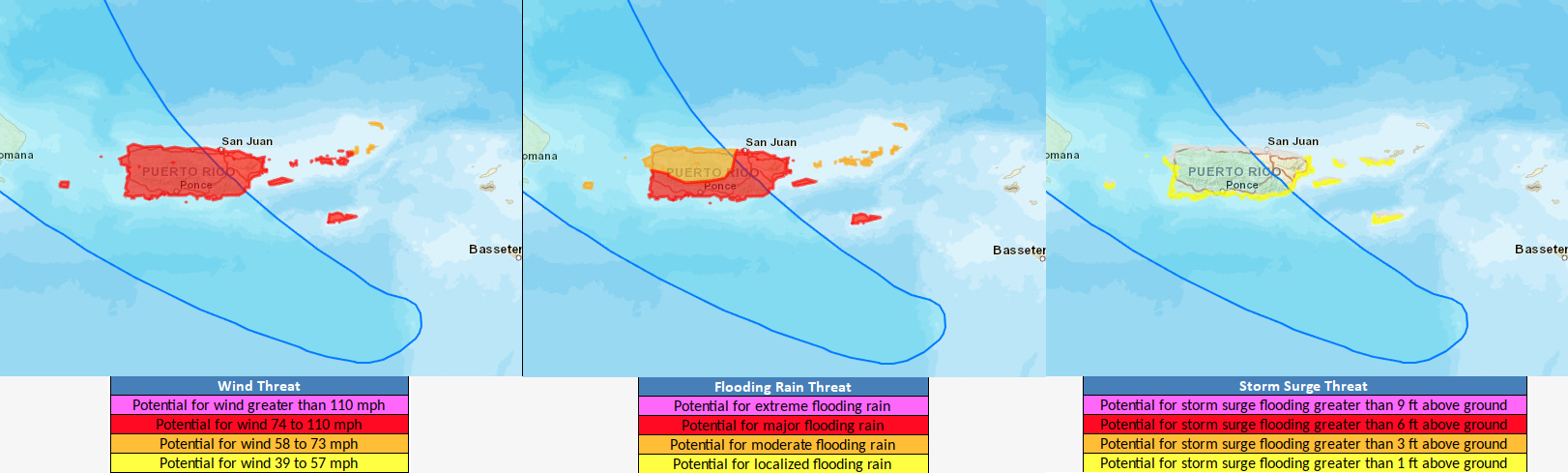
The current suite of wind-rain-surge HTI products is shown here; the Hurricane Threats and Impacts graphics have been an operational NWS product for all tropical cyclones affecting the US since 2015 and provide a valuable threat assessment for the hazards associated with hurricanes. The threats shown on these maps are valid through midday Monday, and the current "cone of uncertainty" is shown for reference.
Although a turn to the north looks quite likely on Monday, there is still a huge amount of uncertainty because of the interaction with the Greater Antilles. This multi-model ensemble provides a nice visualization of the uncertainty in position after it passes north of Hispaniola. That large mountainous island is one of the greatest wildcards that exists in the Atlantic basin. It's far too soon to take the southeast US coast out of the realm of possibilities, though the threat to Bermuda is far greater.

Although that plot doesn't show intensities, there's a lot of agreement among models that Fiona will become a strong hurricane after the Hispaniola encounter, perhaps becoming the season's first major hurricane as early as Monday. Climatologically, over the 1991-2020 period, the season's third hurricane forms on September 7 and the first major hurricane forms on September 1, so by both of those metrics 2022 is slow. Additionally, in terms of ACE (Accumulated Cyclone Energy), this season is at about 44% of average for the date.

No comments:
Post a Comment