
.gif)
Unfortunately, the expectations of rapid intensification in the eastern Gulf of Mexico were met and even exceeded. Ian left the northern coast of Cuba as a low-end Category 3 hurricane and hit the west-central Florida peninsula as an upper-end Category 4 hurricane, just 7 mph shy of Category 5 status. The landfall point is where the center of the eye crosses the coastline, and that was right by Boca Grande, which is about 25 miles north of Fort Myers and 40 miles south of Sarasota.
Keep in mind that a post-season reanalysis is always performed and intensities assigned operationally can be adjusted up or down as necessary. It's possible that Ian was a Category 5 hurricane, it just takes more scrutiny of observations and hindsight than real-time work allows.
For those not familiar with the layout and city names in the area, this map provides a reference, with the approximate landfall point marked by a red dot and the eyewall by a red circle. Areas just south of the landfall point such as Cape Coral, Fort Myers Beach, and Fort Myers experienced the southern eyewall, the full power of the hurricane with onshore winds... maximum wind and storm surge.

Breaking down some numbers, here is an abridged timeline of peak sustained winds (times are EDT, intensities are mph):
Sun 11pm - 65 mph tropical storm
Mon 5am - 75 mph Category 1 hurricane
Mon 5pm - 100 mph Category 2 hurricane
Tues 5am - 125 mph Category 3 hurricane, landfall in Cuba
Tues 11am - 115 mph Category 3 hurricane, exiting Cuba
Wed 5am - 140 mph Category 4 hurricane
Wed 9am - 155 mph Category 4 hurricane
Wed 3pm - 150 mph Category 4 hurricane, landfall in Florida
The hurricane went through an eyewall replacement cycle on Tuesday evening into Wednesday morning... this is a typical process that intense hurricanes go through. The big picture is that the storm's eyewall contracts, dissipates, and gets replaced by a larger eyewall. Hurricanes tend to weaken slightly during this transition, but once it's complete, the overall wind field expands and the storm is primed to re-intensify. That's exactly what Ian did, and it did so just hours before making landfall. In this 36-hour animation from the Key West radar, you see Ian's eye pass over western Cuba, then the eyewall falls apart and a new larger one replaces it.
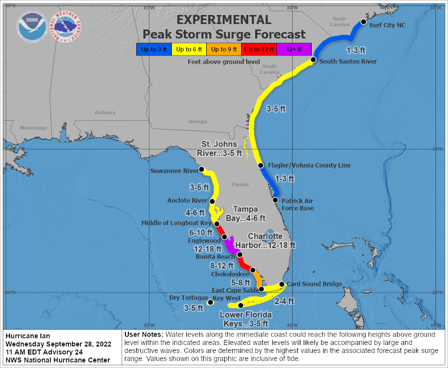
It's hard to say now what the aftermath will look like near the landfall point, but it's impossible for it to not be catastrophic. The last storm surge forecast made before landfall included 12-18 feet in the Charlotte Harbor area, then decreasing away from there, but still extremely high. Wind gusts are estimated to be around 190 mph in the eyewall.
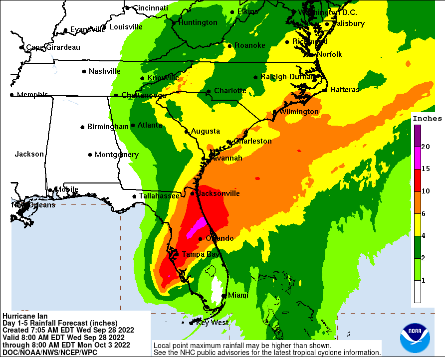
The rainfall forecast is also extreme in central Florida, and high totals extend up into the eastern Carolinas over the next few days as Ian makes its way northeast. It will travel slowly across the Florida peninsula, passing near Orlando and Jacksonville along the way, then re-emerge back over the ocean briefly on Thursday night to make another landfall (MUCH weaker) in Georgia or South Carolina on Friday evening.
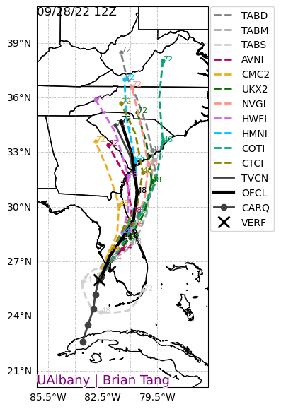
Looking back, the track forecasts from the National Hurricane Center were remarkably consistent; the eventual landfall point in Florida was in the "cone of uncertainty" for Ian's entire life, going back to when it formed last Friday. Just looking at the past three days, this graphic shows every cone overlaid on each other, with the most recent (Wednesday morning) in orange. Keep in mind that the cone is designed to show where the center of the storm might track, with 2/3 probability, and does not tell you where impacts will be experienced. [see "Cone of Uncertainty Update & Refresher"]

Elsewhere across the basin, Tropical Depression 11 formed today in the central Atlantic, but will be very short-lived and I won't go into more detail on it unless it ends up becoming a named storm. If it does, the next name is Julia.
No comments:
Post a Comment