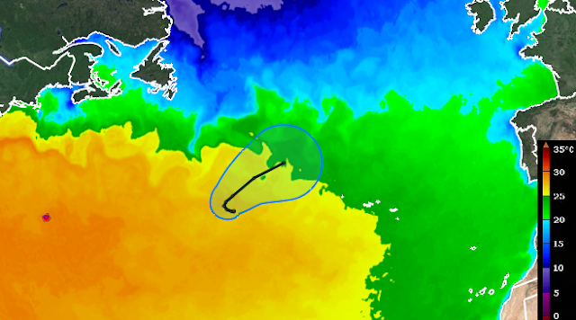
The 2022 Atlantic hurricane season finally has its first hurricane in the books, Danielle. But it didn't form in the tropics, or even the subtropics -- it's way up at 38°N, 700 miles west of the Azores!
Zooming way out, this track forecast and "cone of uncertainty" overlaid on a map of sea surface temperature puts this remote location in perspective. Hurricane Danielle is centered about 1800 miles due east of Delaware and 1800 miles due west of Portugal. Although it's forecast to strengthen more, perhaps a Category 2 hurricane this weekend, it will not affect any land.
Over the past fifty years, the median date of the first hurricane formation is August 6 so this is definitely on the late side. The last time it took longer to get the first hurricane: Hurricane Humberto on September 11, 2013. On this chart below, also notice that in the past fifty years there is virtually no trend in the date (dashed gray line) and no hurricanes formed prior to June 1 (solid cyan line). I don't count Hurricane Alex in January 2016 as the first hurricane of the 2016 season, but rather as the last of the 2015 season, meteorologically.
In terms of ACE (Accumulated Cyclone Energy), the season is now at 12% of average for the date, using that same 1972-2021 baseline. The last few seasons with such low levels of activity through September 2 are 1988, 1941, and 1929. But it's worth pointing out that in 1988, the 13th tropical cyclone of the season was Gilbert (yes, the first 12 were easily forgotten), and that formed on September 8 and went on to become one of the most intense hurricanes in Atlantic history on September 13.
There's still interest in Invest 91L too, which is just 300 miles east of the Leeward Islands. NHC has decreased its probability of formation to 70% in the next five days, but models are still strongly suggesting that it will become Tropical Storm Earl very soon and the season's second hurricane early next week.
This GFS ensemble forecast shows two very different paths the storm could take: remain weak and disorganized and keep tracking toward the west-northwest, OR intensify and turn to the north. It's about a 50/50 split! If it does intensify, the only land that might potentially be at risk is Bermuda next weekend.
Invest 94L, the one that was near Cabo Verde yesterday, is rapidly losing any hope of development and I won't go into detail on it unless it miraculously escapes the shroud of dry air it's in.
- Visit the Tropical Atlantic Headquarters.
- Subscribe to get these updates emailed to you.
- Follow me on Twitter


No comments:
Post a Comment