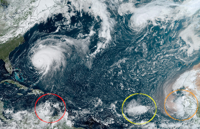
I will keep today's update relatively brief... although there is a lot of activity across the basin, none of it has evolved much since yesterday's post. Fiona is still a Category 4 hurricane about to pass close to Bermuda, Gaston is still a meandering tropical storm near the Azores, and none of the three areas of interest in the deep tropics have become tropical cyclones yet.
 |
| Large-scale satellite image of the Atlantic basin. Hurricane Fiona and Tropical Storm Gaston are the top, while Invest 98L, 99L, and 90L are circled along the bottom. |
Fiona continues to be a very powerful hurricane... it's now been a major hurricane for 2.5 days and it has more to go. It will pass just west of Bermuda tonight, close enough to produce destructive winds and storm surge. Peak sustained winds are still at 130 mph and tropical storm force winds extend an average of 175 miles from the center. In the loop below, Bermuda is the white speck northeast of Fiona's center.
The upcoming landfall in eastern Nova Scotia on Saturday morning is still expected to be historic. As I mentioned yesterday, the storm could break all-time record-low surface pressure values there, and with forecast sustained winds of 90 mph, it will also be one of the most intense storms that area has ever seen... comparable to Juan in 2003 which made landfall on the western end of Nova Scotia.
This most recent run of the HWRF model brings it to landfall with a central pressure of 914 mb, which is just unthinkable. For perspective, at lower latitudes that would be a Category 5 hurricane. This will be a storm for the Canadian history books.
I'm going to skip over Gaston and Invest 99L today and move on to Invest 90L next, which is the disturbance right on the coast of Africa. NHC is giving that a 60% probability of becoming a tropical cyclone within the next couple of days, but not only is it REALLY far east, the forecast is for it to move north!
I found just three other examples of this happening (a wave coming off of Africa, developing, and turning north, all before reaching Cabo Verde): Tropical Storm Becky in 1962, Tropical Storm Ginger in 1967, and an unnamed tropical storm in 1988.
In the satellite loop below, you can see that it has a very limited future -- it's ingesting huge amounts of dry, dusty Saharan air.
Finally, Invest 98L continues to hug the coast of Venezuela and is about to pass just north of Bonaire, Curacao, and Aruba. All of the model guidance indicates that it will begin to drift north away from land, gradually escape the strong wind shear, and likely become a named storm by Sunday when it's south of Jamaica. As hostile as the environment is now, that is likely to change real fast this weekend.
The magnitude of the vertical wind shear is expected to be half of what it is now by Sunday, and half of that again by Wednesday. The images below show the sea surface temperature and the ocean heat content as alternating frames to illustrate where the water is warmest AND where that warm water extends the deepest (ocean heat content values are missing where the water is too shallow). The western Caribbean is primed for whatever comes its way.
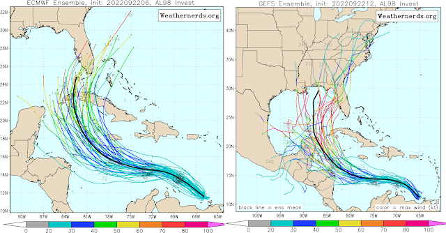
I'll use the same format of track forecasts as before to make comparisons easier. The European model's ensemble is on the left and the American model's ensemble is on the right. I'll point out that the European ensemble has not moved much, while the American ensemble has drifted westward over the past few cycles. Although not shown, the deterministic runs from the global models are not shy about creating a powerful hurricane by Monday. Most favor tracks toward Cuba and then Florida, while the American model tracks the storm into the central Gulf and north from there.
As before, anyone in the Yucatan, Jamaica, Cuba, Florida, and the northern US Gulf coast should be paying close attention and be prepared to begin preparations as the track forecasts narrow. This could be the type of storm that takes a long time to finally form but when it does, there's a short fuse until it makes landfall somewhere as a hurricane.
- Visit the Tropical Atlantic Headquarters.
- Subscribe to get these updates emailed to you.
- Follow me on Twitter


Thank you Brian. Isn't 98L the 9th tropical depression, to become Hermine ? Interesting that Hurricane Hermine was the 9th tropical depression in 2016, and 1st to hit FL since Wilma in 2005, as well as developing in the Gulf, same predicted for 98L. Lots of recurrences here. I'm a S. Fl resident so my hope is the American Model is right.
ReplyDelete