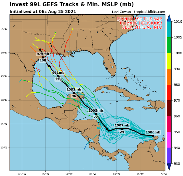
The National Hurricane Center is giving 97L and 99L an 80% chance of becoming tropical cyclones within the next five days, and 30% for 98L. Both 97L and 98L are strongly favored by model guidance to remain far from any land. But 99L poses a significant threat to areas in the western Gulf of Mexico, so I will focus this blog post on that one.
It's hard to say at this point which could become a tropical storm first, but the next three names on the list are Ida, Julian, and Kate. Julian is a new name in the list, replacing Joaquin from the 2015 season.
Invest 99L is currently a disorganized tropical wave hugging the northern coast of Colombia and is forecast to move into the western Caribbean on Thursday-Friday, then over the Yucatan peninsula on Saturday.
Then, there is divergence in the model guidance, with tracks as far south as Tampico and as far east as Mobile, but the heaviest clustering is currently from Corpus Christi to Lafayette. The timing for a potential landfall is looking like Monday into Tuesday.
And although the track guidance will inevitably shift around in the coming days, one thing has consistently been shown: a LOT of rain is expected.
 |
| 7-day rainfall outlook (inches), valid through next Wednesday morning. |
An obvious analog to this scenario is Harvey from the 2017 season. Harvey was also a disorganized easterly wave that tracked through the southern Caribbean in late August, passed over the Yucatan, then quickly developed and rapidly intensified and made landfall as a Category 4 hurricane in a matter of 2.5 days. Then, it stalled over eastern Texas for another three days and dumped up to five feet of rain. This system is not currently expected to intensify or stall quite like that, but models do show it moving relatively slowly as it tracks inland, and some models show it strengthening to a strong hurricane over the Gulf of Mexico.
Since a landfall is possibly just five days away, people in that section of the Gulf coast should be on high alert right now.


No comments:
Post a Comment