15 September 2023

Lee heading for Canada, Margot weakening, Nigel on the horizon

Since my update on Tuesday, Lee and Margot have "behaved" as forecast: Lee turned north, weakened, passed west of Bermuda, and is headed for Nova Scotia.  Margot maintained Category 1 hurricane intensity but just dropped back down to a tropical storm early Friday morning. Finally, Invest 97L became Tropical Depression 15 on Friday morning and will be named Nigel once it reaches tropical storm intensity.  On the satellite loop below, Lee is in the upper left, Margot is in the upper right, and TD15 is in the bottom middle.


Lee is now a Category 1 hurricane and a very large one at that.  Tropical storm winds extend as far as 320 miles from the center, and hurricane winds extend as far as 105 miles from the center. A storm surge of 1-3 feet is possible along much of the New England coast.

It is forecast to make landfall in western Nova Scotia midday Saturday though strong winds will arrive before that... it could be an upper-end tropical storm or Category 1 hurricane, and possibly no longer technically be classified as a tropical cyclone, but that does not change the expected impacts.  This process is called "extratropical transition", and it involves changes in the dynamic and thermodynamic structure and properties of the cyclone.  Extratropical cyclones can also be very intense and impactful (remember Sandy 2012?).


Margot could be around for a while longer, generally maintaining tropical storm intensity.  It found itself in an area of weak steering flow and is just circling around west of the Azores.  Even if it eventually reaches the Azores sometime in the middle of next week, it should not be too much of a concern.


Elsewhere, the Invest 97L and 98L merger happened and has been carried as just 97L... at 11am Eastern on Friday it was upgraded to Tropical Depression 15 and it's quite close to reaching tropical storm status. The next name is Nigel which is a new name on the list, replacing Nate from the 2017 season. 


TD15 is located about 1200 miles east of the Lesser Antilles in the deep tropical Atlantic.  There is strong agreement among the models that TD15/Nigel will continue tracking to the northwest for the next five days or so, then turn north by the time it reaches about 60°W.  The models also agree on it becoming a strong storm -- very likely a hurricane by Monday.


The Accumulated Cyclone Energy (ACE) is at about 148% of average for the date and is the highest value for the date since 2017, then 2008 before that.  In other words, pretty exceptional.


12 September 2023

Hurricane Lee about to turn north, widespread impacts expected in US and Canada

Lee is still major hurricane, and has been since Thursday afternoon ("major" is conventionally defined to be Category 3+).  It's moving toward the west-northwest but the long-awaited north turn should commence later today or early Wednesday.


It's likely going to bring tropical storm conditions to Bermuda on Thursday, then to eastern New England and eastern Canada on Saturday.  It's too soon to know exactly where the center of the storm will go, but it will be a large storm with a broad wind field... areas far from the center will experience impacts.  That said, the model consensus track has been unwavering with a landfall point near western Nova Scotia on Saturday night into Sunday morning.


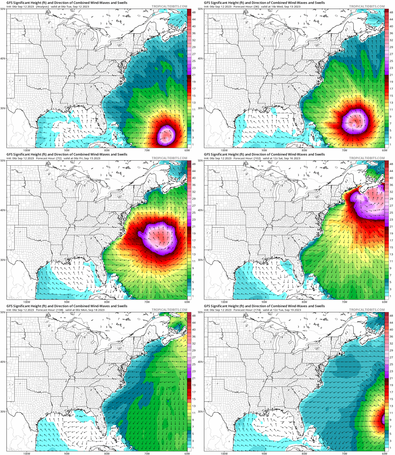
The U.S. east coast, Nova Scotia, and Newfoundland are going to experience some significant impacts from Lee in the coming few days: primarily coastal flooding from storm surge.  To add to the flooding, tides are amplified surrounding Thursday's new moon. The animation below shows the predicted "significant wave height" from the GFS wave model, out to next Tuesday morning.  With the new moon's assistance, this multi-day onshore swell energy is going to create big problems from Florida to Newfoundland.


Margot was upgraded to the season's fifth hurricane on Monday afternoon but it not going to affect land. It's intensifying and is nearly a Category 2 hurricane as of Tuesday morning. It will continue heading north into cooler waters and gradually dissipate in a week or so.


There was a little bit of a traffic jam leaving Africa, and two easterly waves (Invests 97L and 98L) are very close to each other and they might end up merging.  This sloppy beginning could still produce a tropical cyclone, and the model guidance supports that.  NHC is giving it a 70% chance of development within a week.  The GFS ensemble track forecast out to next Tuesday morning is shown below to give a sense of the spread with this so far.

It is certainly something to keep an eye on... should it become a tropical storm, the next name on this list is Nigel.  Nigel is a new name on the list, replacing Nate from the 2017 season.


Climatologically, September 12 is the halfway point of the season in terms of Accumulated Cyclone Energy (ACE).  Through today's date, this year's ACE is the highest since 2017, and actually exceeds the full-season total of many recent years (2015, 2014, 2013, 2009, 2007, 2006, 2002, etc).  It's at 143% of average for the date, and 73% of the full-season average value.


09 September 2023

Watching Hurricane Lee and TS Margot heading into peak week of hurricane season

Unfortunately, I did not get a chance to write a post on Friday... and the reason it's unfortunate is that a very rare explosive intensification had just concluded with Hurricane Lee.  Only two other storms intensified more rapidly than Lee did in the Atlantic: Wilma 2005 and Felix 2007.  The sustained winds increased by 85mph in a day, going from a low-end Category 1 hurricane (80mph) to a Category 5 hurricane (165mph).  There were frequent aircraft reconnaissance flights into the storm that sampled the intensity very well.

For posterity, the infrared satellite animation below spans the 24 hours from Thursday-Friday 5am EDT.  Another interesting and related bit of weather trivia came to life on Friday: 2023 is now the first year in recorded history in which a Category 5 hurricane (or equivalent) occurred in every tropical cyclone basin in the world... see WaPo's Capital Weather Gang article for details.  That's also rather remarkable.


In the meantime, some moderate wind shear and eyewall replacement cycles have weakened the storm a bit, though it's still a formidable major hurricane with 115 mph peak sustained winds.  As of Saturday at 5pm EDT, Lee is a Category 3 hurricane located north of the Leeward Islands and is forecast to regain Category 4 intensity on Sunday and Monday.  The visible satellite below brings us back to current time (Saturday afternoon):


The model guidance is solidly indicating that Lee will turn north on Wednesday, and the NHC forecast reflects that.  It should remain a Category 3-4 hurricane through at least the next five days.


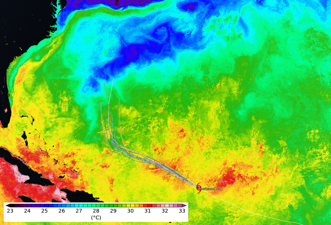
Then, on Friday-ish, Lee will pass over the cold wake that Hurricane Franklin left behind... and it's noticeably colder than the water it's been accustomed to so there is little doubt the hurricane will respond accordingly.  This map shows today's sea surface temperature analysis with some model forecast tracks overlaid.  Tranklin's cold wake is the blue streak that the tracks approach at the end of the forecast period.


Further east, and also on Friday, Tropical Depression 14 became Tropical Storm Margot, the 14th named storm of the season.  It is located in the middle of the tropical Atlantic, far from land, and its forecast track keeps it far from land.  It's expected to become the season's fifth hurricane by the middle of next week.


Not surprisingly, the Accumulated Cyclone Energy (ACE) got a big boost from Lee and will for the next week or so.  As of today, it's roughly 130% of average for the date.  Climatologically, the halfway mark of the season in terms of ACE is coming up on September 12.


As a side note, September 10 is the 6-year anniversary of Hurricane Irma's landfall in Florida... if you're interested in that storm's history, please visit https://bmcnoldy.earth.miami.edu/tropics/irma17/history.html