05 November 2022

Watching disturbance near Hispaniola for impacts in Florida

For several days, models have been hinting at the formation of a low pressure system east of the Bahamas, near Hispaniola and Puerto Rico.  That has finally happened, so it's time to take it seriously... the odds of this becoming a subtropical or tropical cyclone in the near future are high.


It's nothing but a large area of thunderstorms now, but models are abnormally confident about it developing and heading toward Florida by mid-week. We don't have any of the high-resolution hurricane-specific models available for it yet, so we have to rely on the global models and their ensembles.

From the latest cycle of the American and European ensembles, these are the tracks and positions of the low pressures on Thursday morning.


Then, switching to the deterministic runs from the same cycle, these are the surface pressures and winds valid on Wednesday evening.  Don't ever take the details of a 108-hour forecast literally, but these give you an idea of what the two models are doing.


Clearly there's a big difference in intensity, but they agree remarkably well on *something* reaching south-central Florida on Wednesday-Thursday.  Whatever it is by then, it will undoubtedly dump several inches of rain on the area.  The GFS solution is actually a Category 1-2 hurricane when it reaches the southeast Florida coast, so although not likely, it's not out of the question either.

Also notice the structure of it: it looks likely that the stronger winds (and heavier rain) will be north of the center, not symmetric like a classic tropical storm or hurricane.  

One final and significant impact to mention is widespread and prolonged coastal flooding.  The winds from this storm will be conducive for onshore flow from the Carolinas down to Florida, then you combine that with already-elevated tides for a few days around Tuesday's full moon, and there could be hundreds of miles of coastal flooding from Monday through Thursday.

Elsewhere, there's a strong low pressure system located east of Bermuda, tagged as Invest 97L.  This could also develop into a subtropical or tropical cyclone in the near future, but will innocently track off to the northeast into the north-central Atlantic.


The next two names on the list are Nicole and Owen.


02 November 2022

Two simultaneous hurricanes... in November

As eluded to in yesterday's post, both Lisa and Martin did indeed become hurricanes on Wednesday, and they're both active at the same time.  This would not be too noteworthy in the core months of August, September, or October, but it's absolutely exceptional in November.  In fact, it's only been observed twice before: in 2001 and 1932.

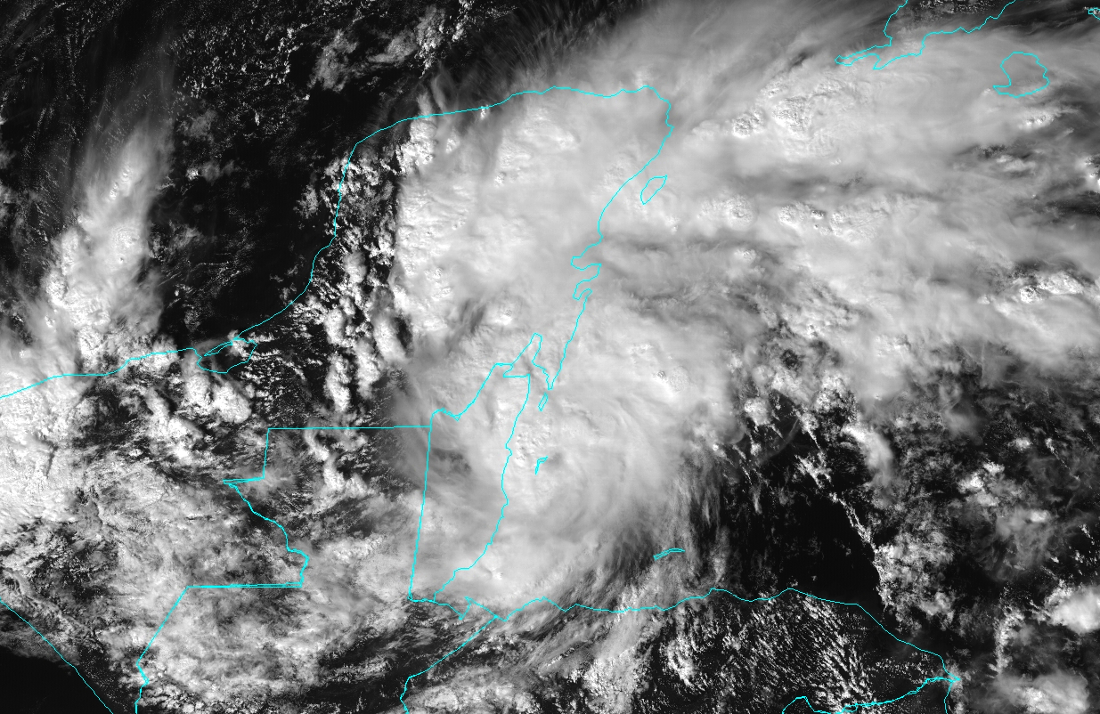
Lisa is going to make landfall in Belize as a Category 1 hurricane on Wednesday afternoon, that country's first such landfall since Nana in 2020.


Once it makes landfall it will quickly weaken, but produce significant rainfall over Belize, Guatemala, and southern Mexico before what's left of it moves back out over the Bay of Campeche.  The National Hurricane Center's forecast indicates a weak tropical depression moving out into the bay, then turning back to the southeast and dissipating over Mexico.


Martin is flourishing in a brief window of favorable conditions, but it is expected to transition to a strong extratropical cyclone sometime on Thursday as it travels over increasingly cold water.


In the forecast map below. the white-filled forecast positions mean that it will not be a tropical (or subtropical) cyclone anymore. 


It's worth a quick mention that the two examples of the "cone of uncertainty" shown in this post from Lisa and Martin are identical in size and in their construction.  All storms during the entire hurricane season have the same "cone" whose size is determined by track errors over the previous five seasons.  For a full refresher on this, please visit 2022 "Cone of Uncertainty" Update & Refresher.

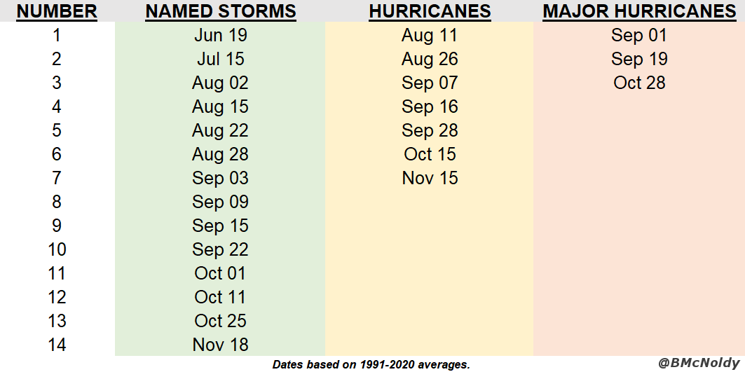
This mini burst of activity has provided a small boost to the season's total Accumulated Cyclone Energy (ACE), which is now at about 77% of average for the date.  Within 24 hours, both Lisa and Martin will likely no longer be contributing to the ACE tally.  In terms of storm numbers, the season has had 13 named storms, 7 hurricanes, and 2 major hurricanes... the climatological average for a full season is 14, 7, and 3. 


01 November 2022

November kicks off with Tropical Storm Martin as Lisa strengthens

Let this be a lesson in model confidence: one day ago Tropical Storm Lisa's prospects for intensification were not too high, and the rest of the Atlantic looked pretty quiet with just low chances of formation near Bermuda (I didn't even bother mentioning it).  Today, Lisa is a strengthening mid-range tropical storm and Tropical Storm Martin formed well east of Bermuda.


Although Lisa is still battling some westerly wind shear, the appearance is drastically more symmetric compared to yesterday, so the dry air I mentioned did not sneak into the circulation as much as expected, and the extremely warm ocean helped to give it a kick.

Lisa is still expected to make landfall in Belize on Wednesday evening, and the odds of it reaching hurricane intensity prior to then are higher now... several more dynamical models are on board with that scenario.  It could re-emerge over the Bay of Campeche on Friday-Saturday, but the model guidance is really scattered on how it evolves after a couple days over land.

The last few hurricanes to make landfall in Belize were Nana (2020), Earl (2016), and Richard (2010).

Martin, the season's 13th named storm, has been a trackable feature for several days now, but looked fairly benign and the models were not too bullish on it.  But in the past day it really got organized in a hurry and is a bona fide tropical cyclone.  


It too could become a hurricane in the near future, but its time is limited before it transitions to a potent extratropical cyclone over the far north-central Atlantic.

Martin is a new name in this list, replacing Matthew which was retired after the 2016 season.


Climatologically, the season's 13th named storm forms on October 25, so this is just a week behind that average date.  There have been five hurricanes so far this season, so if Lisa AND Martin make it, that would bring the total up to seven which is the average number during a full season.