
Milton continues its trek toward Florida, and very little has changed since yesterday's post.
.gif)
Overnight, there was an eyewall replacement cycle... this is a common process that intense hurricanes go through periodically in which a larger eyewall develops outside of the original smaller one. The smaller one decays away and the outer one becomes the only one. During this process the storm's intensity typically decreases and the wind field expands. Then, the new eyewall contracts, the storm re-intensifies, and another cycle may begin. It can happen multiple times in a storm's lifetime.
As of Tuesday afternoon, Milton is a strong Category 4 hurricane and appears to be back on an intensification trend again. Tropical storm conditions are expected to reach the Florida peninsula on Wednesday afternoon, with landfall in the Tampa area late Wednesday night. Destructive winds and storm surge will of course reach far beyond that area though.


The flooding threat from heavy rain is also extremely high through the central part of the peninsula, but then very little rain is expected in the coming days in the panhandle and down in urban southeast Florida. Fortunately, Milton will be moving rather quickly as it crosses the state, so the rainfall totals are not uncommonly high for a landfalling tropical cyclone. I also have a long, updating radar loop set up to monitor rainfall over the state as Milton comes through: https://bmcnoldy.earth.miami.edu/tropics/radar/

And not to throw yet another graphic at you, but this is pretty interesting: right before landfall,
Milton's inner core will pass over some of the warmest water of its entire journey: 30-31°C (86-88°F), which is 2-3°C (3.5-5.5°F) warmer than average for this time of year. Although some stronger wind shear should start to weaken the hurricane, it will still be very powerful and this last-minute bit of warmer water won't help.

Leslie weakened to a tropical storm on Tuesday morning after nearly six days a hurricane. It is forecast to continue weakening and dissipate in the central Atlantic in a very uneventful fashion.
Those two areas of potential formation that I pointed out in yesterday's post are still in the outlook and are both at a 20% probability for formation within a week.
.png)
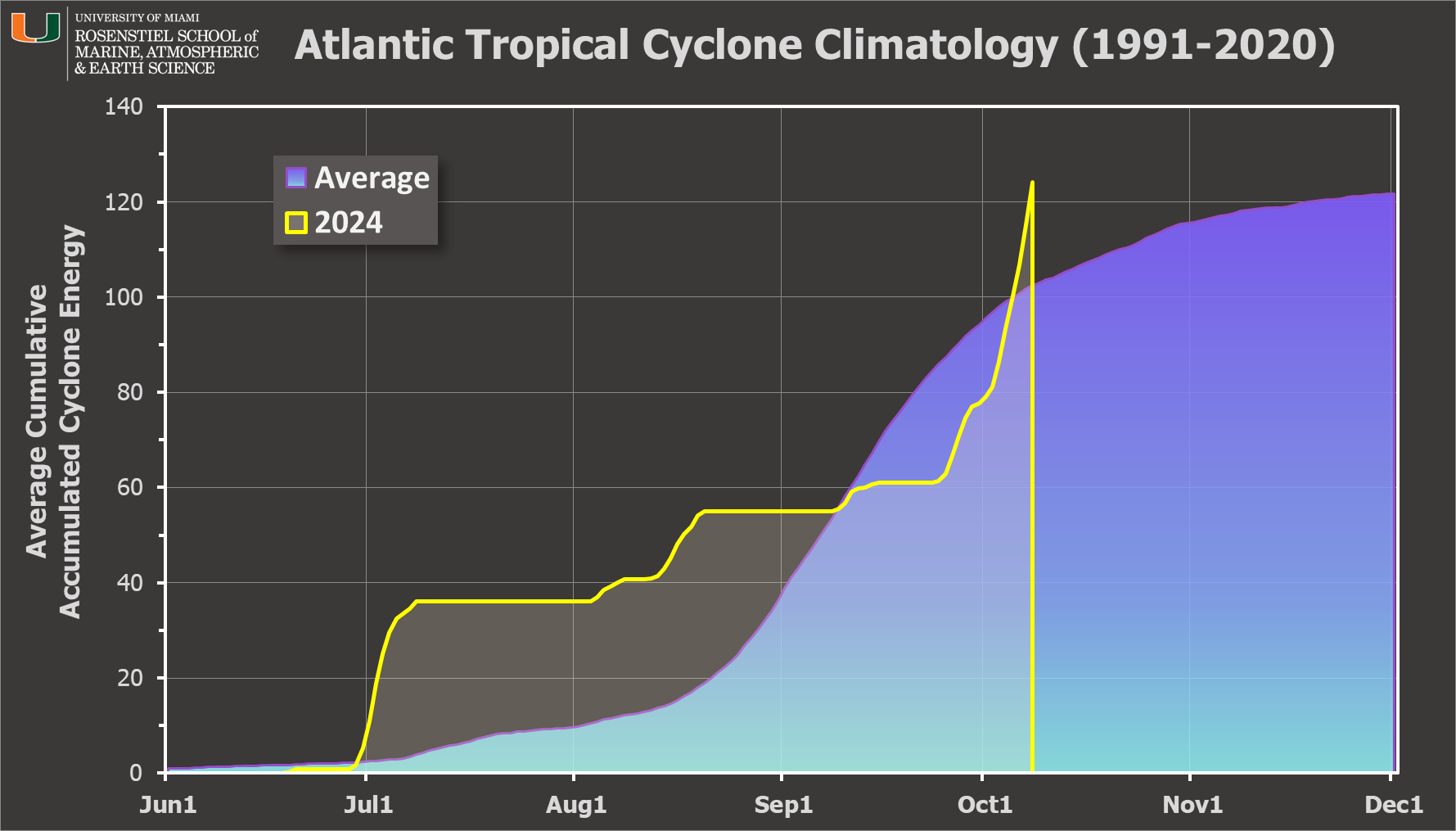
For those keeping track of Accumulated Cyclone Energy (ACE), today is actually a noteworthy day: the value accrued just surpassed the average amount during an entire average season today. So with Leslie and Milton still active, it will continue to climb.
Thank you Brian. Your information is always on point and trustworthy.
ReplyDeleteThanks Brian, you are the go to person to get the straight info on the storm.
ReplyDelete