Since my previous post on Friday morning, there have not been a lot of surprises. The disturbance of interest did indeed become Tropical Depression 4 on Friday night, then Tropical Storm Debby on Saturday afternoon when its center was west of the Florida Keys. It tracked northward and briefly attained hurricane status for twelve hours as it made landfall in the Big Bend area of Florida early Monday morning. From my post on Friday:
"Climatologically, the fourth named storm forms on August 15, and the second hurricane forms on August 26... so if Invest 97L does become Tropical Storm Debby OR Hurricane Debby, it will be well ahead of the normal pace."
 |
| 18-hour enhanced infrared satellite loop; landfall was at approximately 11:00 UTC. |
I didn't include it in this post, but I have a very long radar animation of Debby available at https://bmcnoldy.earth.miami.edu/tropics/radar/
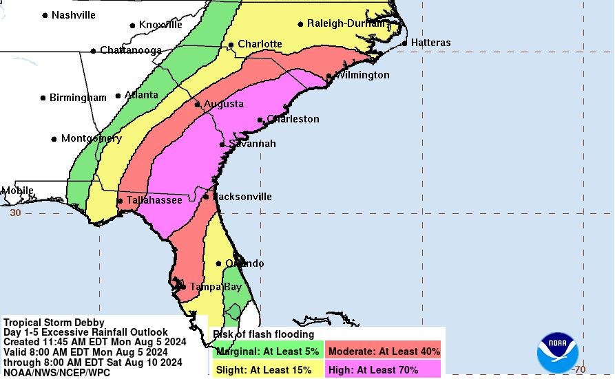
As of Monday afternoon, winds have decreased to tropical storm strength, but the forecast keeps it around for a few more days as it stalls near the coast of the Carolinas. That stall will be responsible for a very significant flooding threat this week. This map below shows the five-day rainfall forecast from Debby -- those high totals over northern Florida, Georgia, South Carolina, and North Carolina will undoubtedly be devastating in many locations.

Debby is another perfect example of two important lessons with tropical cyclones:
1) The storm doesn't stop at landfall. Quite often, there are days of flash flooding and/or tornado threats after landfall and far from the landfall location, so don't tune it out.
2) There's more to the story than the category. The only thing the category rating of a hurricane tells you is what the peak sustained wind is somewhere in the storm. However, the large majority of fatalities and damage comes from rainfall and storm surge (i.e., water). Even a tropical depression can easily produce catastrophic flooding.
Tropical storm warnings are still up for Florida's Big Bend region and then over in eastern GA and SC as Debby is expected to meander back out over the ocean to recharge.

Elsewhere, there's an easterly wave that just crossed the Windward Islands that has a small chance of development in the Caribbean this week... it should reach the Yucatan peninsula area on Friday-Saturday, but as of now it does not appear to be a threat. The next name on this year's list is Ernesto.

- Visit the Tropical Atlantic Headquarters.
- Subscribe to get these updates emailed to you.
- Follow me on Bluesky and X
No comments:
Post a Comment