The center of Tropical Storm Cristobal is just 60 miles from the Louisiana coastline as of 8am CDT, but storm surge and associated thunderstorms sprawl for hundreds of miles east of the center, affecting Mississippi, Alabama, Georgia, and Florida. Maximum sustained winds are 50 mph and it's moving to the north at 12 mph. This will bring it to landfall shortly after noon, local time. However, there's nothing too special about the technical landfall since the storm is so broad and disorganized... impacts extend far from the center all day.
(this and other long radar loops of Cristobal are available at http://bmcnoldy.rsmas.miami.edu/tropics/radar/)
One of those impacts is storm surge, which is water that gets pushed onto land by the storm's wind. Fortunately, Cristobal will generate only modest storm surges, peaking in the 3-5-foot range in eastern Louisiana. This below with the inset shows an example from Shell Beach, LA... the unfortunate part is that the maximum surge should arrive right around high tide, resulting in water levels that are perhaps 5 feet above the normal high tide.
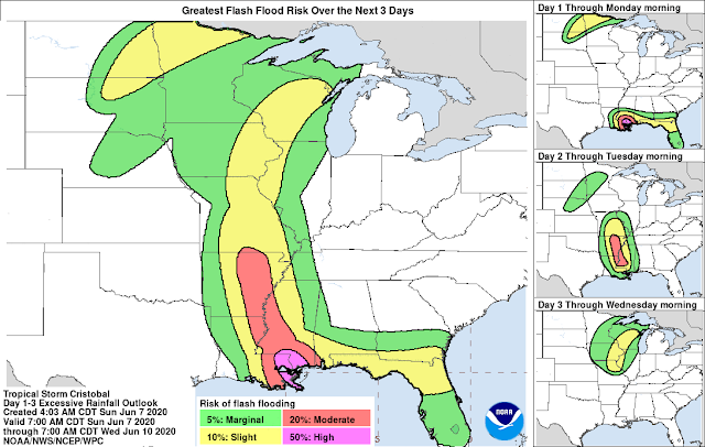
Another impact will be flooding due to heavy rain. And this is not limited to a coastal event like storm surge is. Flooding rainfall will follow Cristobal up into Mississippi, Arkansas, Missouri, Illinois, Iowa, etc. There will be an interaction with an approaching mid-latitude cyclone which will amplify the rainfall totals so far north.
Finally: tornadoes. All landfalling tropical cyclones are capable of spawning numerous tornadoes, and Cristobal is no exception. On Saturday night, there were seven tornado reports in the northern Florida peninsula near Orlando. More are possible today in eastern LA, south MS, southern AL, and the Florida panhandle. These are typically weak but fast-moving, so be on high alert today for warnings and have a shelter plan already in mind.


No comments:
Post a Comment