30 September 2022

Ian's third and final landfall in South Carolina


Fifteen days after leaving the African coast, Ian's last few hours are here.  It became a tropical depression on the 23rd, made landfall in western Cuba as a Category 3 hurricane on the 27th, then in central Florida as a Category 4 on the 28th, and now in South Carolina as a Category 1 on the 30th.


Although Ian is on the cusp of becoming an extratropical cyclone, it still poses the same threat (remember Sandy in 2012?).  It's a Category 1 hurricane with 85 mph peak sustained winds, and made landfall between Charleston and Myrtle Beach on Friday afternoon at about 2pm local time.  Ian will dissipate over the Carolinas and Virginia in the next day or so, and after dropping a few inches of rain over those areas, that will be the end of it.


Storm surge was and is the primary threat today, and some areas have definitely experienced severe coastal flooding today.


There is another wave of interest just moving off the African coast today.  Like Ian, it's coming off at a very low latitude, but unlike Ian, it's likely to turn to the northwest within a week.  After that, there's some divergence in the model guidance so it's just something we'll need to keep an eye on now and then -- it's very far from any land.  If it becomes a tropical storm, the next name is Julia.


September was extremely active... of the nine named storms so far this season, six of them formed in September.  In terms of ACE, September accounts for 94% of the total at this point, two-thirds of the way through the season.  And compared to the average over the past fifty years, 2022 is now at 97% of the average value for the date.


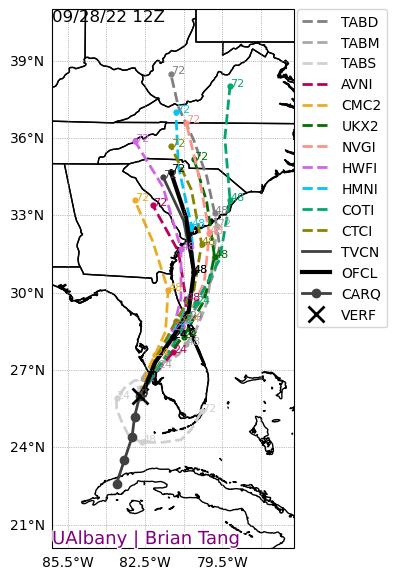
As of Friday afternoon, these next two images show the history of NHC forecasts for Ian: track on top then intensity below.  The observed track and intensity is the thick black line, and each six-hourly forecast is shown by a colored line.

As it relates to the Florida landfall, the "cone of uncertainty" always contained the eventual landfall point... every advisory for all five days from Ian's formation on the 23rd to its landfall on the 28th.  The cone is designed to show where the center of the storm should track, with 2/3 likelihood.  Having that long to prepare for what was forecast to be a major hurricane landfall is very good, but it doesn't stop the damage from happening, unfortunately.  All people can do is get out of its way.

29 September 2022

Back over water, Hurricane Ian is poised to make yet another landfall

After making landfall as an upper-end Category 4 hurricane on Wednesday afternoon, Ian took its time traversing the Florida peninsula.  It briefly weakened to a tropical storm, but the center of now Hurricane Ian re-emerged over the Atlantic Ocean midday Thursday.  It's interacting with a mid-latitude trough that is stretching its cloud shield out to England.  No, seriously... England!


This 3-day radar animation is quite amazing in what it covers in the lifecycle of a tropical cyclone.  You can find this and others at http://bmcnoldy.rsmas.miami.edu/tropics/radar/


Although Ian is back over water, it's in a very different environment than it was before reaching Florida.  It's now in high vertical wind shear and is well on its way to becoming an extratropical cyclone.  But before it does so, it regained hurricane status today before making landfall in South Carolina midday Friday.


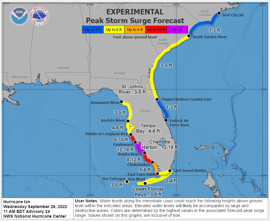
Regardless of the exact intensity, the outcome will be the same.  It will create a fairly high storm surge of 4-7 feet in the central part of the state, as well as 6-10 inches of rain.  This won't be nearly as severe of a landfall as the one in Cuba or Florida, but it is still extremely dangerous and life-threatening.  Seven feet of ocean coming at you with angry waves on top is very serious.


The current suite of Hurricane Threat & Impacts is shown here, and the "cone of uncertainty" is overlaid for reference.  Keep in mind that the cone is ONLY designed to show you where the center of the storm might track (with 2/3 probability).  Impacts can and always do extend far beyond the cone.


Now that' we're headed for a bit of reprieve in activity, here's an update on where the season stands in terms of Accumulated Cyclone Energy.  The current total is about 96% of average for this date if we use the past fifty years as the baseline.  The very quiet first half of the season was met with a very active September (the average ACE  September is 50 and we're at 74).


28 September 2022

Ian makes landfall as upper-end Category 4 hurricane in Florida


Unfortunately, the expectations of rapid intensification in the eastern Gulf of Mexico were met and even exceeded.  Ian left the northern coast of Cuba as a low-end Category 3 hurricane and hit the west-central Florida peninsula as an upper-end Category 4 hurricane, just 7 mph shy of Category 5 status.  The landfall point is where the center of the eye crosses the coastline, and that was right by Boca Grande, which is about 25 miles north of Fort Myers and 40 miles south of Sarasota.

Keep in mind that a post-season reanalysis is always performed and intensities assigned operationally can be adjusted up or down as necessary.  It's possible that Ian was a Category 5 hurricane, it just takes more scrutiny of observations and hindsight than real-time work allows.

For those not familiar with the layout and city names in the area, this map provides a reference, with the approximate landfall point marked by a red dot and the eyewall by a red circle.  Areas just south of the landfall point such as Cape Coral, Fort Myers Beach,  and Fort Myers experienced the southern eyewall, the full power of the hurricane with onshore winds... maximum wind and storm surge.


Breaking down some numbers, here is an abridged timeline of peak sustained winds (times are EDT, intensities are mph):
Sun 11pm - 65 mph tropical storm
Mon 5am - 75 mph Category 1 hurricane
Mon 5pm - 100 mph Category 2 hurricane
Tues 5am - 125 mph Category 3 hurricane, landfall in Cuba
Tues 11am - 115 mph Category 3 hurricane, exiting Cuba
Wed 5am - 140 mph Category 4 hurricane
Wed 9am - 155 mph Category 4 hurricane
Wed 3pm - 150 mph Category 4 hurricane, landfall in Florida

The hurricane went through an eyewall replacement cycle on Tuesday evening into Wednesday morning... this is a typical process that intense hurricanes go through.  The big picture is that the storm's eyewall contracts, dissipates, and gets replaced by a larger eyewall.  Hurricanes tend to weaken slightly during this transition, but once it's complete, the overall wind field expands and the storm is primed to re-intensify.  That's exactly what Ian did, and it did so just hours before making landfall.  In this 36-hour animation from the Key West radar, you see Ian's eye pass over western Cuba, then the eyewall falls apart and a new larger one replaces it.


It's hard to say now what the aftermath will look like near the landfall point, but it's impossible for it to not be catastrophic.  The last storm surge forecast made before landfall included 12-18 feet in the Charlotte Harbor area, then decreasing away from there, but still extremely high.  Wind gusts are estimated to be around 190 mph in the eyewall.


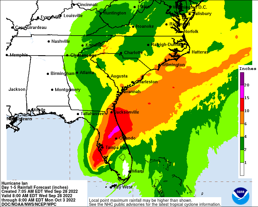
The rainfall forecast is also extreme in central Florida, and high totals extend up into the eastern Carolinas over the next few days as Ian makes its way northeast.  It will travel slowly across the Florida peninsula, passing near Orlando and Jacksonville along the way, then re-emerge back over the ocean briefly on Thursday night to make another landfall (MUCH weaker) in Georgia or South Carolina on Friday evening.


Looking back, the track forecasts from the National Hurricane Center were remarkably consistent; the eventual landfall point in Florida was in the "cone of uncertainty" for Ian's entire life, going back to when it formed last Friday.  Just looking at the past three days, this graphic shows every cone overlaid on each other, with the most recent (Wednesday morning) in orange.  Keep in mind that the cone is designed to show where the center of the storm might track, with 2/3 probability, and does not tell you where impacts will be experienced.  [see "Cone of Uncertainty Update & Refresher"]


Elsewhere across the basin, Tropical Depression 11 formed today in the central Atlantic, but will be very short-lived and I won't go into more detail on it unless it ends up becoming a named storm.  If it does, the next name is Julia.