29 September 2022

Back over water, Hurricane Ian is poised to make yet another landfall

After making landfall as an upper-end Category 4 hurricane on Wednesday afternoon, Ian took its time traversing the Florida peninsula.  It briefly weakened to a tropical storm, but the center of now Hurricane Ian re-emerged over the Atlantic Ocean midday Thursday.  It's interacting with a mid-latitude trough that is stretching its cloud shield out to England.  No, seriously... England!


This 3-day radar animation is quite amazing in what it covers in the lifecycle of a tropical cyclone.  You can find this and others at http://bmcnoldy.rsmas.miami.edu/tropics/radar/


Although Ian is back over water, it's in a very different environment than it was before reaching Florida.  It's now in high vertical wind shear and is well on its way to becoming an extratropical cyclone.  But before it does so, it regained hurricane status today before making landfall in South Carolina midday Friday.


Regardless of the exact intensity, the outcome will be the same.  It will create a fairly high storm surge of 4-7 feet in the central part of the state, as well as 6-10 inches of rain.  This won't be nearly as severe of a landfall as the one in Cuba or Florida, but it is still extremely dangerous and life-threatening.  Seven feet of ocean coming at you with angry waves on top is very serious.


The current suite of Hurricane Threat & Impacts is shown here, and the "cone of uncertainty" is overlaid for reference.  Keep in mind that the cone is ONLY designed to show you where the center of the storm might track (with 2/3 probability).  Impacts can and always do extend far beyond the cone.


Now that' we're headed for a bit of reprieve in activity, here's an update on where the season stands in terms of Accumulated Cyclone Energy.  The current total is about 96% of average for this date if we use the past fifty years as the baseline.  The very quiet first half of the season was met with a very active September (the average ACE  September is 50 and we're at 74).


28 September 2022

Ian makes landfall as upper-end Category 4 hurricane in Florida


Unfortunately, the expectations of rapid intensification in the eastern Gulf of Mexico were met and even exceeded.  Ian left the northern coast of Cuba as a low-end Category 3 hurricane and hit the west-central Florida peninsula as an upper-end Category 4 hurricane, just 7 mph shy of Category 5 status.  The landfall point is where the center of the eye crosses the coastline, and that was right by Boca Grande, which is about 25 miles north of Fort Myers and 40 miles south of Sarasota.

Keep in mind that a post-season reanalysis is always performed and intensities assigned operationally can be adjusted up or down as necessary.  It's possible that Ian was a Category 5 hurricane, it just takes more scrutiny of observations and hindsight than real-time work allows.

For those not familiar with the layout and city names in the area, this map provides a reference, with the approximate landfall point marked by a red dot and the eyewall by a red circle.  Areas just south of the landfall point such as Cape Coral, Fort Myers Beach,  and Fort Myers experienced the southern eyewall, the full power of the hurricane with onshore winds... maximum wind and storm surge.


Breaking down some numbers, here is an abridged timeline of peak sustained winds (times are EDT, intensities are mph):
Sun 11pm - 65 mph tropical storm
Mon 5am - 75 mph Category 1 hurricane
Mon 5pm - 100 mph Category 2 hurricane
Tues 5am - 125 mph Category 3 hurricane, landfall in Cuba
Tues 11am - 115 mph Category 3 hurricane, exiting Cuba
Wed 5am - 140 mph Category 4 hurricane
Wed 9am - 155 mph Category 4 hurricane
Wed 3pm - 150 mph Category 4 hurricane, landfall in Florida

The hurricane went through an eyewall replacement cycle on Tuesday evening into Wednesday morning... this is a typical process that intense hurricanes go through.  The big picture is that the storm's eyewall contracts, dissipates, and gets replaced by a larger eyewall.  Hurricanes tend to weaken slightly during this transition, but once it's complete, the overall wind field expands and the storm is primed to re-intensify.  That's exactly what Ian did, and it did so just hours before making landfall.  In this 36-hour animation from the Key West radar, you see Ian's eye pass over western Cuba, then the eyewall falls apart and a new larger one replaces it.


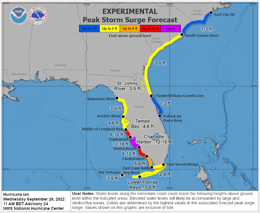
It's hard to say now what the aftermath will look like near the landfall point, but it's impossible for it to not be catastrophic.  The last storm surge forecast made before landfall included 12-18 feet in the Charlotte Harbor area, then decreasing away from there, but still extremely high.  Wind gusts are estimated to be around 190 mph in the eyewall.


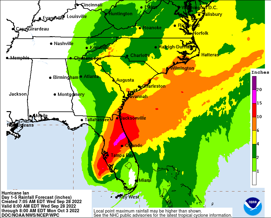
The rainfall forecast is also extreme in central Florida, and high totals extend up into the eastern Carolinas over the next few days as Ian makes its way northeast.  It will travel slowly across the Florida peninsula, passing near Orlando and Jacksonville along the way, then re-emerge back over the ocean briefly on Thursday night to make another landfall (MUCH weaker) in Georgia or South Carolina on Friday evening.


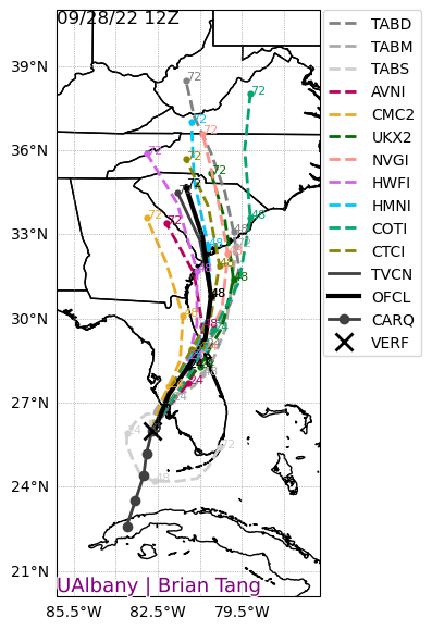
Looking back, the track forecasts from the National Hurricane Center were remarkably consistent; the eventual landfall point in Florida was in the "cone of uncertainty" for Ian's entire life, going back to when it formed last Friday.  Just looking at the past three days, this graphic shows every cone overlaid on each other, with the most recent (Wednesday morning) in orange.  Keep in mind that the cone is designed to show where the center of the storm might track, with 2/3 probability, and does not tell you where impacts will be experienced.  [see "Cone of Uncertainty Update & Refresher"]


Elsewhere across the basin, Tropical Depression 11 formed today in the central Atlantic, but will be very short-lived and I won't go into more detail on it unless it ends up becoming a named storm.  If it does, the next name is Julia.

27 September 2022

Major Hurricane Ian crosses Cuba and enters Gulf of Mexico

As expected, Ian rapidly intensified and became the season's second major hurricane on Tuesday morning.  (A "major hurricane" is simply defined to be a Category 3+ hurricane on the Saffir-Simpson Scale).  It crossed the western tip of Cuba and the eye is now back over water.  It is forecast to make landfall in the Tampa area as a Category 3-4 hurricane on Wednesday night.


Zooming in on the eye, it's amazing to watch it quickly clear out after leaving Cuba -- Ian wasted no time re-intensifying and it's undoubtedly well on its way to becoming a Category 4 hurricane.


Ian has been in continuous radar coverage since Sunday morning, and you can find the archived and current radar loops at http://bmcnoldy.rsmas.miami.edu/tropics/radar/.  This view shown below is a mosaic of many radars to create a regional-scale image.


It has now been 12 days since Ian left the African coast as an easterly wave, and 4 days since it became a tropical cyclone.  Now the final days are here, and they are extremely impactful.  Tropical storm, hurricane, storm surge, flood, and tornado watches and warnings plaster nearly all of Florida and even into Georgia and South Carolina.


The Tuesday afternoon suite of Hurricane Threats & Impacts (HTI) graphics are shown here.  These break the hurricane down into its four hazards (wind, surge, rain, and tornado) and provide relative threat levels from each hazard.  As you can see, the entire peninsula will experience impacts from Hurricane Ian, but the worst is focused on the central part of the west coast.  If you are anywhere that's covered by a threat in red or purple, be prepared for some serious and even life-threatening impacts from the corresponding hazard.


As far as winds go, tropical storm conditions will gradually work their way northward along the peninsula, beginning with Key West this afternoon, and wrapping up around Jacksonville on Thursday morning.  Although not shown here, the hurricane's large wind field will amplify coastal flooding issues on the east and west coasts... water levels were already running high because of the new moon and time of year.  The storm surge near landfall is quite different; that is far more dire and life-threatening than elevated tides elsewhere in the state.


Between the landfall in Cuba and then in Florida, there's little doubt that the name Ian will be retired after only its second use (it replaced Igor in 2016).  This would make it the 13th "I" name to be retired since tropical cyclones were given names in the Atlantic, by far more than any other letter.  To make the "Curse of the I" more complete, it's also in September and it's also likely going to peak at Category 4 intensity -- all three of these traits reinforce the existing leaders of retired names.