As I wrote in yesterday's post, a long-track major hurricane is a certainty. There is significant agreement among the models that Lee will turn north next Tuesday-Wednesday somewhere between 65-70°W. But a few stragglers from various ensembles and several model cycles stubbornly do not follow the pack and fail to make the north turn. The map below shows the tracks from the Thursday morning GFS model ensemble -- the forecast period of these tracks ends next Friday morning (Sept 15th).
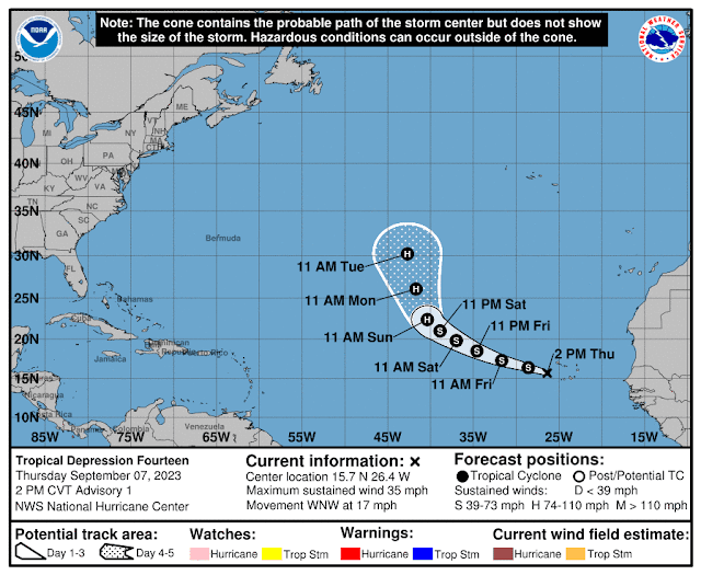
Former-Invest 96L is now Tropical Depression 14 and it's also getting its act together quickly; it'll probably be the 14th named storm later today or early Friday. The next name is Margot, which is a new name on this list... it replaced Maria after its retirement in 2017.The model guidance indicates a turn to the north by the time it reaches about 45°W, and the NHC forecast closely follows that. It has a shot at reaching Category 3 intensity in 4-5 days but will not affect land.
Climatologically (1991-2020), an entire season has 14 named storms, but we're not even to the halfway point of this season yet in terms of ACE (that's coming up on September 12). And just as a refresher, the 2022 hurricane season ended with 14 named storms.
 As expected, Lee is rapidly intensifying east of the Leeward Islands and is now officially forecast to be a Category 5 hurricane on Friday-Saturday. Additionally, the easterly wave I mentioned yesterday that was near Cabo Verde has been upgraded to Tropical Depression 14 and is likely to become the season's fifth hurricane this weekend. Its name will be Margot.
.gif)


No comments:
Post a Comment