Hurricane Dorian is centered about 415 miles east of West Palm Beach FL and moving toward the west at 8 mph. Tropical storm force winds now extend an average of 105 miles from the center. It is headed for the western Bahamas on Sunday, and then is forecast to have significant impacts along Florida's east coast on Monday-Tuesday. Beyond that, places further north into Georgia and the Carolinas should be starting to prepare for hurricane conditions by Tuesday-Wednesday.
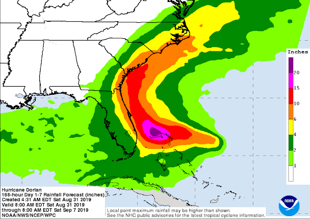
The map below shows the latest rainfall guidance over the coming week. This is not welcome news to eastern SC and NC where Florence dumped record-breaking rainfall last September.
With this shift in model guidance, many more people are in harm's way. A major hurricane tracking along the southeast coastline is a big problem. And even if the center never technically crosses the coastline and makes landfall, strong winds will affect land, and storm surge will impact every coastal city along the way. A direct major hurricane landfall in South Carolina (think Hugo 1989) or North Carolina (think Floyd 1999) would be catastrophic.
The map below shows the 50-member European model ensemble forecast tracks through the next 7 days:
The history of major hurricanes passing within 150 miles of Dorian's current position includes several "recurvers", but also some infamous names like Floyd '99, Andrew '92, Hugo '89, Gloria '85, and Betsy '65 that have all been retired.
 |
| Tracks of historic hurricanes that were all at least Category 3 intensity and within 150 miles of Dorian's location. |
- Visit the Tropical Atlantic Headquarters.
- Subscribe to get these updates emailed to you.
- Follow me on Twitter


Brian you are great. Thanks buddy!
ReplyDelete