
Large and powerful Lorenzo has just passed the Azores and is headed toward Ireland. It still has peak sustained winds of 80 mph and is racing toward the northeast at 43 mph. Tropical storm force winds extend as far as 390 miles from the center, while hurricane force winds extend as far as 150 miles from the center.
It will undoubtedly be a major problem in Ireland, with destructive winds and significant storm surge. Port cities such as Galway will experience severe flooding on Thursday. Tropical storm force winds should arrive in Ireland on Thursday morning, followed quickly by hurricane force winds and a rapidly rising storm surge. I have a long radar loop from Ireland at http://bmcnoldy.rsmas.miami.edu/tropics/radar/.
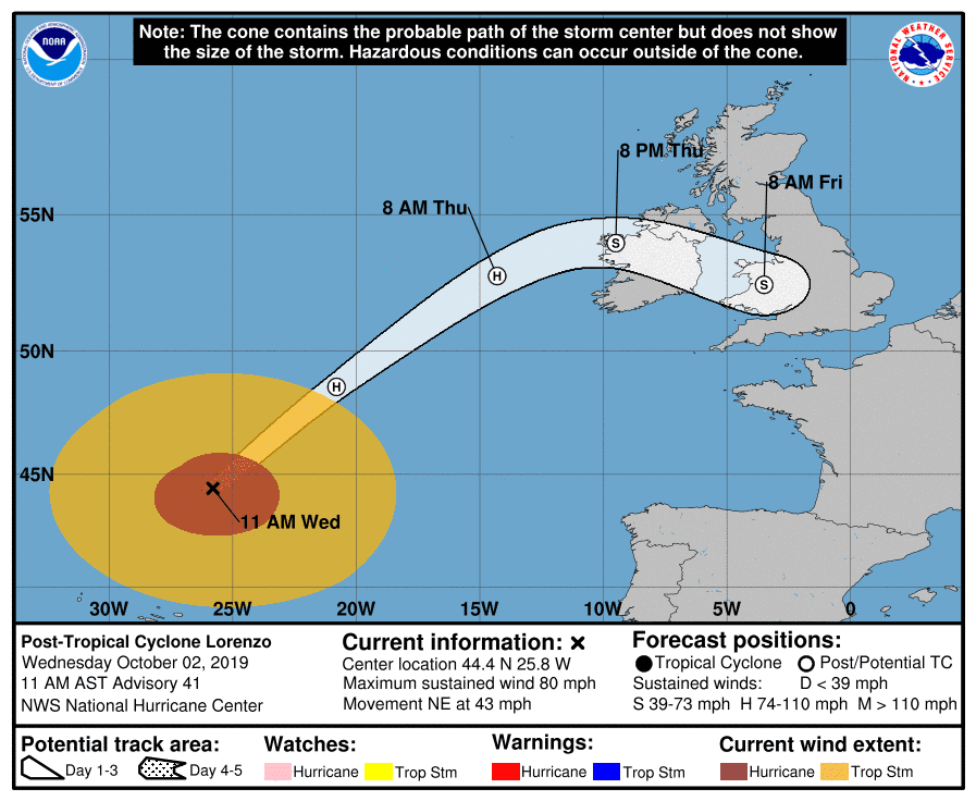
I found 18 tropical or post-tropical cyclones that passed within 100 miles of the Irish coast since 1851, and the most recent was Ophelia in October 2017, which made landfall as a post-tropical cyclone with sustained hurricane-force winds (80mph). Debbie was the same intensity and was debateably still a hurricane when it made landfall in northwest Ireland in September 1961. Edna was a little stronger than Ophelia and Debbie (85mph), and made landfall in northwest Ireland in September 1953 as a post-tropical cyclone. Then the strongest on record was a post-tropical cyclone with nearly Category 2 sustained winds (90-95mph) that made landfall in southwest Ireland in September 1883. We will see on Thursday where Lorenzo will fit into history.
 |
| Tracks of tropical and post-tropical cyclones that passed within 100 miles of Ireland since 1851. The gray lines indicate the storm was post-tropical. |
Elsewhere, the Atlantic basin remains relatively quiet for the foreseeable future. There is a disturbance south of Cuba that has a low chance of development as it heads west toward the Yucatan Peninsula, and there's a wave still over Africa that models indicate could develop early next week in the far eastern Atlantic.
No comments:
Post a Comment