30 October 2023

Monitoring two areas for formation in the coming week


There are two areas of interest in the Atlantic that could become tropical cyclones in the coming week.  The first is near the northern Bahamas and the second is just south of Puerto Rico.  The one near the Bahamas (Invest 96L) has a hostile environment ahead of it, but the one in the eastern Caribbean (should soon be tagged as Invest 97L) is one to keep a close eye on.  The next -- and final -- two names on this year's regular list are Vince and Whitney.   
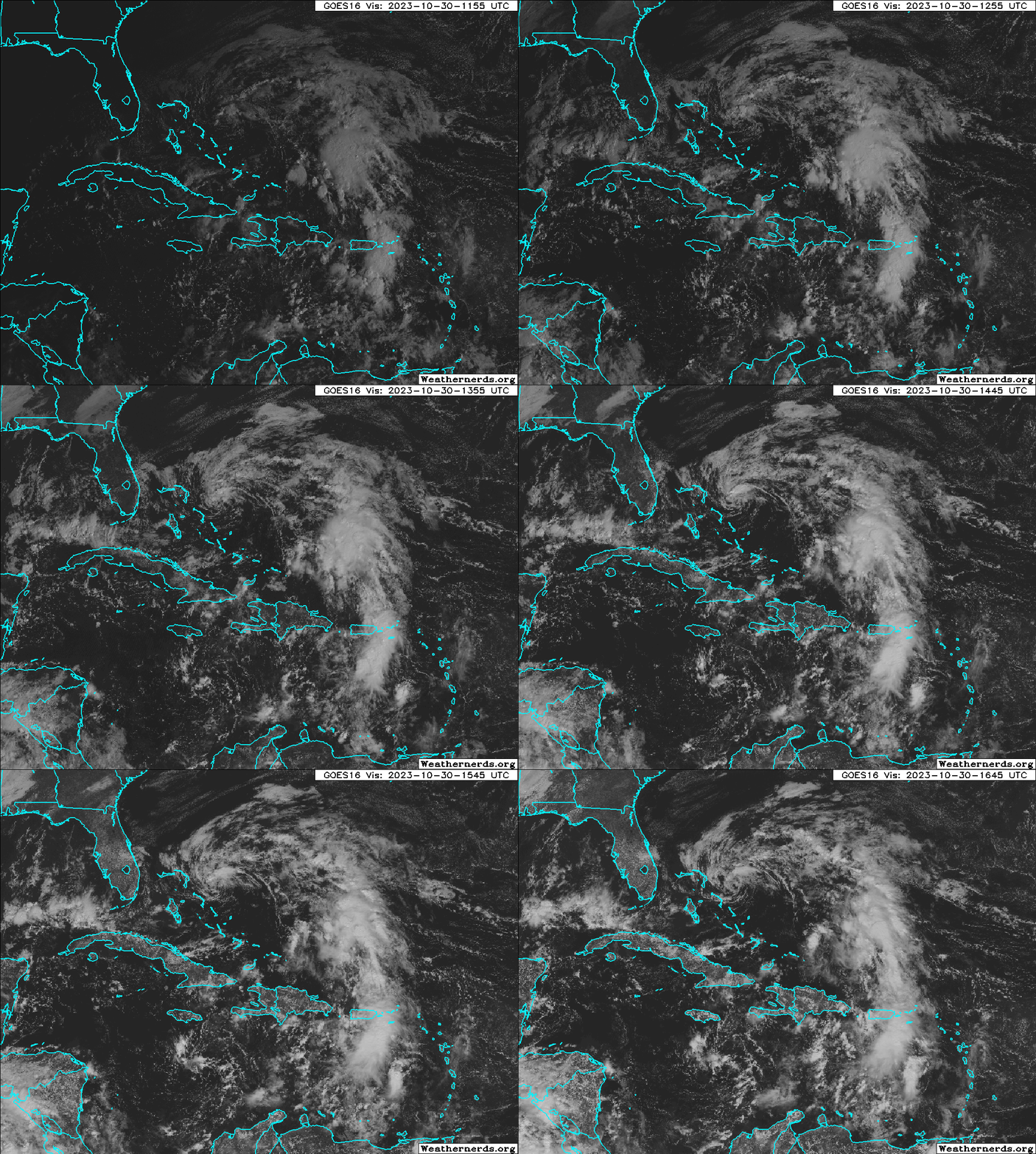

The discussion of Invest 96L will be very brief.  It's already encountering drier air and stronger vertical wind shear and both are expected to only become less favorable for development in the coming days.  Model guidance is in good agreement on it remaining very weak... either never form or perhaps briefly become a low-end tropical storm.  It will zip off to the northeast away from land and dissipate.


The feature in the eastern Caribbean is very poorly defined right now, but should gradually consolidate in the next couple of days.  There's a large difference between how the American and European model ensembles handle its future.  This first animation is a 10-day forecast from the American model's ensemble system.  The swarm of low pressures starts appearing on Wednesday and they track westward across the Caribbean.  The majority run into central America and subsequently dissipate, and about six of the members turn north and hit Cuba as a hurricane.  After Cuba, the Bahamas or even south Florida would be potential areas of concern.  The timing of the potential encounter in south Florida would be next Tuesday-Wednesday, but there is a LOT of uncertainty in this right now.


Switching over to the same animation from the European model ensemble, very few of the members do anything with it, and the ones that do are decidedly weaker than in the American ensemble.


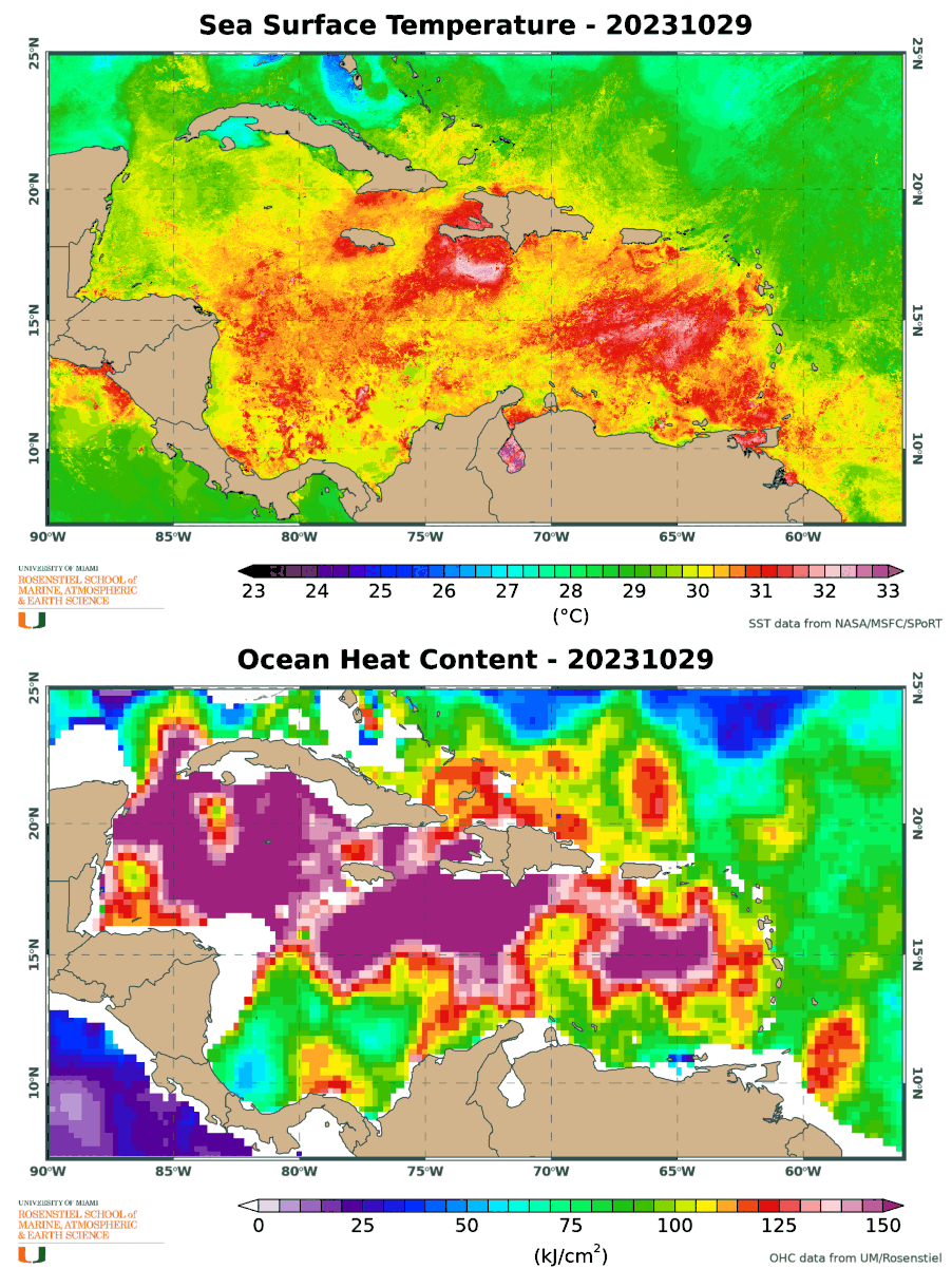
But one thing is for certain: the Caribbean Sea is still extremely warm (1-2°C warmer than average for the date) and that warm water is deep, resulting in huge values of ocean heat content.  These factors will give a nudge to development and intensification, and be able to sustain a storm of any intensity.

Without a named storm out there, the Accumulated Cyclone Energy (ACE) is no longer accruing, and as of today, the 2023 tally is about 126% of average for the date.  But, as described in this post, we probably aren't done for the year yet.  Hurricane season officially ends on November 30.


Historically, the 2023 season sits rather high in the ranking for the date (in the top 12%):


23 October 2023

Hurricane Tammy's very uncertain future could involve Florida


Since my previous post on Thursday, Tammy reached Category 1 hurricane intensity prior to its approach to the Leeward Islands, but the eyewall passed just barely to the east of the islands.  It has been tracking northwest -> north since then, and unfortunately, that enormous uncertainty in the track forecast I pointed out on Thursday has not gotten any closer to being reduced.


As of Monday morning, Tammy is a Category 1 hurricane centered about 250 miles north of the Virgin Islands and it's moving north at 7 mph.  But by mid-week, models diverge significantly on the track forecast.  Among global model ensemble members, roughly half bring Tammy west toward Florida and the other half stall or go east into the open Atlantic.  But the greatest "track density" (shown below) is near south Florida on the 29th.


For the batch that reaches Florida, the timing as of now looks to be as early as Friday and as late as Sunday, with most making the closest approach on Saturday the 29th.  It's worth pointing out that there is a full moon on the 28th, so water levels could create tidal flooding problems around every high tide for the few days surrounding that... even without help from Tammy. 

Although it's still a long way out, the intensity guidance ranges from a very weak remnant to a Category 1 hurricane, so a tropical storm seems like a reasonable best guess for now if it makes the west turn.  If it goes east, it has a chance at becoming a stronger hurricane.  Most models show a fairly hostile environment if it goes west, so the odds of Tammy still being a hurricane by the weekend are pretty slim.

The official forecast from NHC drops it to tropical storm intensity by Thursday, and their track forecast is a compromise between the west and east scenarios, with a slight lean to the western ones.  If one scenario starts to dominate in the model guidance, their track forecast will reflect that.


Elsewhere, Invest 95L is a disturbance brewing in the far western Caribbean... about to move inland over Nicaragua.  It appears to be very close to becoming a tropical cyclone, and if it reaches tropical storm intensity, the next name on the list is Vince.  Otherwise, it will cross Nicaragua and could become a tropical cyclone in the East Pacific.


Looking at the Accumulated Cyclone Energy (ACE) through today, it's about 125% of average for the date and climbing higher above climatology each day while Tammy is around.


19 October 2023

Tammy forms and triggers watches & warnings in Leeward Islands


Invest 94L was upgraded to Tropical Storm Tammy on Wednesday afternoon; Tammy is the 20th named storm of this very active season.  It is forecast to become the season's 7th hurricane on Saturday as it passes over or very near the Leeward Islands.

As of Thursday morning, a tropical storm watch covers islands from Barbados up through Anguilla; the tropical storm warning and hurricane watch are for Guadeloupe.  These will definitely evolve, so stay tuned to NHC for the latest.  [link to map for a refresher on the names of the islands in the Lesser Antilles]


A useful product from NHC is the arrival time of tropical storm winds, overlaid on the probability of those winds occurring.  This too is updated every six hours, so check back on the NHC website.


The last hurricanes to pass over these islands were Maria and Irma in 2017... both at Category 5 intensity and only two weeks apart.  Thankfully, this time won't be anything remotely like that.  Intensity guidance from the models is in the tropical storm and Category 1 hurricane range when Tammy is crossing over the Leeward Islands. 

Beyond the weekend, models are in absolutely no agreement on where Tammy will go.  In one week, the ensemble spread of track forecasts from the global models spans from Haiti to Ireland and everywhere in between. So, best to just focus on 3-day forecasts for now until there's more consensus.