30 August 2023

Idalia rapidly intensifies and makes landfall, Franklin weakening

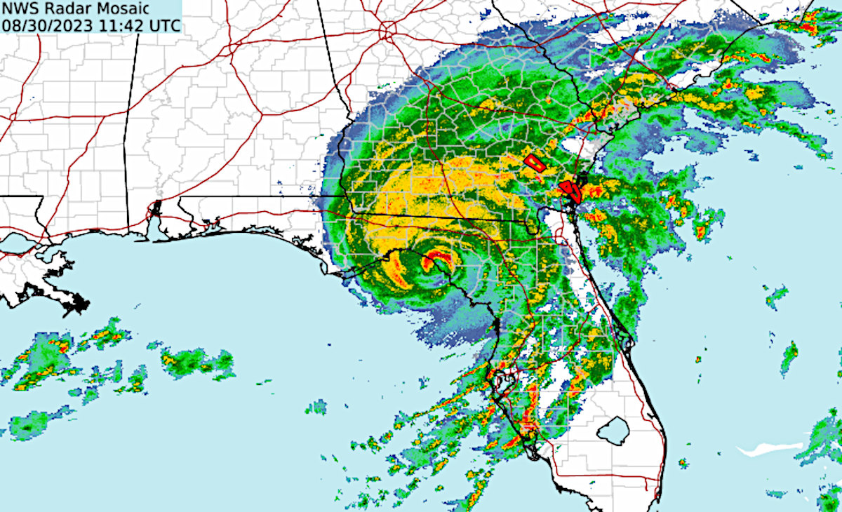
I unfortunately did not have time to write a post on Tuesday, but a lot happened.  On Tuesday morning, Idalia had just become a Category 1 hurricane.  By Tuesday night it was a Category 2 hurricane and by Wednesday morning it was a Category 4 hurricane.  The peak wind speed increased by 58 mph in 24 hours: rapid intensification.  The storm took full advantage of the hyper-hot water temperatures in the eastern Gulf and minimal wind shear.


It made landfall in the Big Bend region of Florida, and the last time that part of the state experienced anything like this was 1896.  The peak winds dropped slightly as it was making landfall so it was technically a Category 3, but at that point it was too little too late.  That part of the state is extremely surge-prone because of the concave shape of the coastline, though it will be a while until we know the official peak storm surge values.

It's not over of course, as the storm is tracking over Georgia, then South Carolina and North Carolina, creating rainfall flooding and coastal flooding issues along the way.  The full suite of NHC products is available at https://www.nhc.noaa.gov/graphics_at5.shtml?start#contents, but this map shows the probability and timing of tropical storm winds.


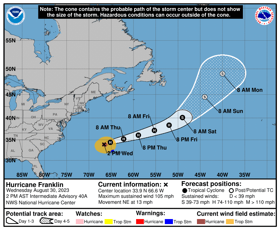
Franklin has passed west of Bermuda and is now weakening as it heads into the north-central Atlantic. It will become a strong extratropical cyclone this weekend over the cold ocean there.

But wait, there's more!  Tropical Depression 11 formed on Tuesday morning, though it's not expected to be around long.  Ex-Gert is actually still lingering out there and also has a dim future.  Then there's a new easterly wave that just left Africa yesterday, Invest 94L.  That is strongly favored to develop by the models, but almost certainly turn north into the open ocean.  I won't go into any detail now, but the wave behind that one looks like potential trouble in model-land.  That should leave the continent on Sunday or so...


Not surprisingly, the ACE has spiked due to these two major hurricanes and is now at 138% of average for the date.  If the activity magically switched off right now, the ACE would slip back to the average value in just one week: September 5.


As far as named storm counts go, here's the latest status.  Any way you slice it, this season is well ahead of average for the date.


28 August 2023

Idalia to bring significant impacts to Florida, Franklin becomes Category 4 hurricane

The two features of interest in the Atlantic, Idalia and Franklin, continue to strengthen...


Idalia is just a sneeze away from becoming the season's third hurricane as it nears the western tip of Cuba.  It is finally moving slowly to the north and will enter the Gulf of Mexico tonight.  It has been affected by some moderate northerly vertical wind shear which has kept the thunderstorm activity displaced to the south of the surface circulation, but as the day goes on, that displacement is decreasing and it appears that Idalia is close to beginning a period of rapid intensification.  We've been fortunate to have continuous radar coverage of the storm since Friday from Cancun in Mexico and from La Bajada in Cuba: https://bmcnoldy.earth.miami.edu/tropics/radar/


This set of Hurricane Threats and Impacts (HTI) graphics is from Monday morning but in the few hours since then, these maps have not changed much.  These graphics have been an operational NWS product for every single tropical cyclone near the U.S. since 2015, and I've been a big proponent of them because they put the focus on the hazards rather than the track.  There are four threat levels for each of four hurricane hazards: wind, storm surge, rainfall, and tornadoes.


Idalia is forecast to make landfall in Florida's Big Bend region as a Category 3 hurricane on Wednesday morning, with tropical storm conditions beginning Tuesday evening. There are too many evolving watches and warnings to put in here, but visit https://www.nhc.noaa.gov/graphics_at5.shtml?start#contents for the latest.  And remember, being outside of "the cone" does not mean you are safe... the cone has nothing to do with impacts -- that's what watches and warnings are for.

Meanwhile, south of Bermuda, Franklin was upgraded to the season's first major hurricane today, and subsequently strengthened even more to reach Category 4 status. As of early Monday afternoon, Franklin had 145 mph peak sustained winds and is still forecast to strengthen... perhaps briefly reaching Category 5 status later today.


Bermuda is under a tropical storm watch, and tropical storm winds could reach the island on Tuesday evening, with the storm's closest approach on Wednesday morning.  But Franklin's winds are also driving some hefty swells and elevated water levels along the US east coast, aggravating what are already-high tides this week around the full moon.


The ACE has just popped back above 100% of average for the date for the first time since August 18 (now at 107%).  The next 2-3 days will produce a big spike in the tally.


27 August 2023

Tropical Storm Idalia has eyes on Florida as Franklin strengthens south of Bermuda

On Sunday morning, Tropical Depression 10 was upgraded to Tropical Storm Idalia, the 10th named storm of the season.  Climatologically, the 10th named storm forms on September 22, so this is definitely ahead of that pace.  The storm is stalling between the Yucatan peninsula and Cuba as expected, and should start moving toward the Gulf of Mexico on Monday morning.  Hurricane watches are in effect for parts of Florida.


Sunday afternoon's model runs had the benefit of aircraft reconnaissance data.  Unfortunately, the guidance has trended stronger and it's now looking very likely that somewhere in the northern Gulf coast of Florida will experience a hurricane landfall, perhaps a major hurricane, on Wednesday.  Tropical storm force winds could begin Tuesday morning in parts of southwest Florida and then Tuesday evening in northwest Florida.  That means just two days of preparation time as of Sunday evening there.

The global model ensembles show a track toward Florida's Big Bend area and landfall centered around Wednesday morning.  However, it's important to note the spread to see the current realm of potential outcomes based on these models.  And then remember that a hurricane is not a point or a line, it's hundreds of miles across.  So as always, impacts such as flooding rain, storm surge, and strong winds occur well away from the center. 


We can also look at the latest suite of deterministic model tracks, and they include a couple that are on the far southern periphery of the ensemble spread shown above.


Then we have the official NHC forecast and the track forecast cone.  For this, remember that it's a deterministic forecast and the accompanying cone represents a 2/3 likelihood of the path of the center of the storm (using the error statistics from the previous five years).  So 1) there's still a 1/3 chance the center of the storm tracks outside of the cone and 2) the cone tells you nothing about where impacts will be experienced.  (see 2023 "Cone of Uncertainty" Update & Refresher).  Keep yourself updated on the latest forecast, watches, and warnings related to Idalia at https://www.nhc.noaa.gov/refresh/graphics_at5+shtml/174602.shtml?cone#contents.


After its encounter with Florida, Georgia, South Carolina, and North Carolina will have to contend with it, and one factor this coming week is an exaggerated risk of coastal flooding because of abnormally high tides around the Full Moon.

Franklin is still in the open ocean between Hispaniola and Bermuda.  It should avoid a direct hit on Bermuda, but the island now has a rather high chance of experiencing tropical storm conditions on Tuesday night.  It is forecast to become the season's first major hurricane tomorrow, which is just four days ahead of climatology.


With a tropical storm and a hurricane churning simultaneously, the Accumulated Cyclone Energy (ACE) is accruing at a pace just in line with climatology.  The ACE is at 93% of average for the date.