16 September 2016

Atlantic now has three named storms for first time in four years

Ian, Julia, and Karl are all tropical storms now, a level of activity not seen in the Atlantic since 2012 when Isaac, Kirk, and Leslie were all active. However, it will be hard to touch the record of four simultaneous hurricanes in the Atlantic: Georges, Ivan, Jeanne, and Karl in 1998 (note that Georges, Ivan, and Jeanne have since been retired).

Infrared satellite image of the Atlantic basin on Friday morning. (CIMSS)
Contrary to model guidance, nature decided that Julia was not finished yet, and it was re-upgraded to a tropical storm on Thursday afternoon.  The official forecast still calls for it to weaken and remain nearly stationary though, so it is not expected to become a threat to land.


Ian is still clinging onto tropical cyclone status, though barely.  This is the last you'll hear about it, but it did hang around long enough to assist with the "three simultaneous named storms" statistic!

And last but not least, Tropical Depression 12 was upgraded to Tropical Storm Karl, the 11th named storm of the season.  In an average season, the 11th named storm forms on October 28!  But as before, the overall activity as measured by ACE (Accumulated Cyclone Energy) is still lagging behind... roughly 74% of average for this date.  In other words, the season has had a lot of weak storms: they get named but don't get very strong or last for very long.


Karl is expected to remain relatively weak for the next several days, but by the middle of next week it could be in a position to intensify as it heads west. This graphic below shows a three-day forecast of the surface pressure and mid-level humidity -- Karl is the low pressure near 47°W surrounded by dry air (the next easterly wave behind it may also get named next week... it would be Lisa).


 In the longer range, most models still agree that it will get stronger and track toward the west-northwest.  It's too early to say if it will recurve toward Bermuda or keep a heading more toward the U.S.  Shown here is a plot of track forecasts from the GFS ensemble (a global dynamical model run multiple times with slightly different initial conditions to simulate uncertainty).  The lines are colored by intensity.  At this point, the majority have it recurving before it reaches 70°W, but that can change.


15 September 2016

Julia, Ian, and TD12 are scattered across the Atlantic

Today's update will be brief, as very little has changed since yesterday.

Surface wind field showing the circulations of the three active tropical cyclones in the Atlantic. (earth.nullschool.net)
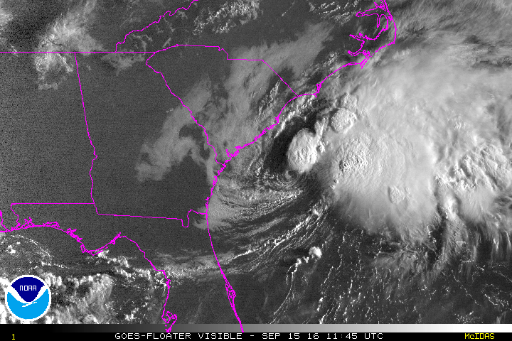
Julia did eventually drift offshore after I wrote yesterday's post, and it also weakened to a tropical depression. It is expected to dissipate this weekend, but should remain virtually stationary the entire time due to a lack of steering flow.  This morning it is centered 85 miles east of the SC/GA border, with the "business end" (heavy rain, and thunderstorms, and strongest winds) displaced to the east of the center and away from land.

Sunrise over Tropical Depression Julia on Thursday morning.
Ian is still a moderate tropical storm with 50 mph peak winds, but remains embedded in a high-shear environment. The center is about 750 miles south-southeast of Newfoundland, but as you can see in the satellite image below, a frontal boundary is forming to its south, a tell-tale sign that it is transitioning to an extratropical cyclone.  NHC will likely cease writing advisories on it today or tomorrow.


And finally, Tropical Depression 12 is still forecast to battle with dry air for the next few days, but probably have a shot at intensification next week.  Should it reach tropical storm status, the next name on the list is Karl. It's presently not looking very ominous... just a low-level swirl with some widely scattered thunderstorm activity to its south.


The long-range forecasts are worth paying some attention to, at least to start watching for trends and consistency.  The plot below shows track forecasts from a variety of dynamical models out to 5-7 days, as well as the NHC forecast (black line).  There is general agreement that it will continue its westward motion and reach the area north of the Leeward Islands by late next week.  It is far too early to say anything certain about the intensity at that time, but for what it's worth, today's model runs indicate it would not be a hurricane at that point.


Stay tuned!


14 September 2016

Julia forms over Florida, Ian still a tropical storm, TD12 forms over Cabo Verde Islands

The peak of hurricane season isn't failing this year.  There are two active tropical storms, and a new tropical depression off the coast of Africa.


The tenth named storm of the season, Julia, formed near Jacksonville FL on Tuesday night.  It actually formed over land, and the center has not spent any time over water, and probably never will.  This is extraordinary, and from what I can tell, unprecedented.  While there are a dozen examples of Atlantic tropical cyclones forming inland near a coastline (Agnes 1972 over the Yucatan Peninsula, Leslie 2000 over northern Florida are two examples), they did eventually track over water and strengthen. Julia can be traced back to an easterly wave that left the African coast on September 1st.

Tropical Storm Julia on Wednesday morning.  Previous center locations are marked with red dots.
Julia is expected to weaken to a depression later today over South Carolina... the primary threat is heavy rainfall, and parts of eastern SC could receive 6-10" of rain over the next few days as it crawls northward.

During an average season (using a 1981-2010 climatology), the 10th named storm forms on October 10th, so this season is now about 3.5 weeks ahead by that measure.  But in terms of ACE (Accumulated Cyclone Energy), the season is still at roughly 73% of average for this date.

In the far eastern Atlantic, over the Cabo Verde Islands, Tropical Depression 12 has formed and could get named in the next day or two.  The next name on the list is Karl, a name that was on one of the original six lists of names in 1980.


Models strongly favor this depression to develop to at least a tropical storm, and they also agree on a track toward the west over the next 5 days.  On this general trajectory, the system would reach the Lesser Antilles by late next week. But it will likely struggle with wind shear and dry air for the next three or so days.

A selection of global and regional dynamical model forecast tracks for TD12, valid out through Monday morning.
Finally, as expected, Tropical Storm Ian has not intensified, and is embedded in strong vertical wind shear in the middle of the Atlantic.  It is no threat to land, and is forecast to transition to an extratropical cyclone by the weekend.

Visible satellite image of Tropical Storm Ian on Wednesday morning.
Forecast track of Ian over the next five days. (NOAA/NHC)