
Since my update on Thursday, Franklin did eventually become the second hurricane of the season on Saturday morning and the disturbance that was over central America trekked north and is now Tropical Depression 10 near the northeast tip of the Yucatan Peninsula.

Franklin should manage to avoid land (west of Bermuda, south of Nova Scotia and Newfoundland) but is forecast to intensify further, perhaps becoming a major hurricane (Category 3+) on Monday-Tuesday. After that, wind shear will increase dramatically and the ocean temperature under it will become rather chilly for hurricanes. If Bermuda does get scraped with tropical storm conditions, it would be on Tuesday.

The disturbance we've been watching for several days in the western part of the basin was just upgraded to Tropical Depression 10 on Saturday afternoon, and it has certainly developed an ominous satellite presentation during the day. When this reaches tropical storm intensity, the next name on the list is Idalia (replacing Irma six years ago).

We also have the benefit of excellent radar coverage between Cancun in Mexico and La Bajada in Cuba (latest animations can be found at https://bmcnoldy.earth.miami.edu/tropics/radar/):

The NHC forecast brings this to hurricane intensity on Tuesday as it makes landfall somewhere in the northern Gulf coast of Florida. Model guidance has a pretty big spread though, with some models bringing it to Category 3 intensity at landfall. In terms of track, this map below shows the track density from four global model ensembles combined. Depending on the track it takes, notice that after Florida, areas to the north such as South Carolina and Georgia will also experience some impacts (the map doesn't explicitly show impacts, just track density).

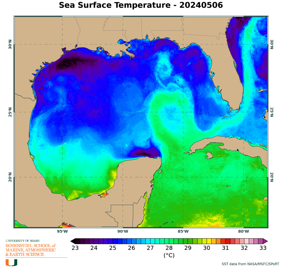
Keep in mind the water temperatures in the western Caribbean and eastern Gulf of Mexico are extremely warm -- even warmer than average for this time of year which is saying a lot. This will increase the odds of rapid intensification any time the center is over water. Rapid intensification is notoriously challenging to reliably forecast.
Based on the initial official forecast, here are the probabilities and most likely arrival times of tropical storm force winds. Remember, it's not a tropical storm yet, so the chances are relatively low near its present location. A key part of the forecast is an anticipated stall near the tip of the Yucatan peninsula... it should start moving again on Monday. A lot rests on where the inner core stalls (land vs water).

Given the uncertainty, anyone in Florida should be watching this extremely closely and be mentally preparing to start taking action on Sunday-Monday. A strong hurricane landfall on Tuesday-Wednesday is not out of the question.
Since this will inevitably come up, "I" storms are indeed the most frequently retired, and it's not even close. This is mostly just luck, because if it was related to the time of year, then "H" and "J" storms should be pretty high too (or "G" and "K" for that matter), and they're not. Of the 13 "I" storms that have been retired over the past 70 years, 7 of them have been just in the last 14 years (Ike, Igor, Irene, Ingrid, Irma, Ida, Ian). Let's hope we don't have a reason to add Idalia to the list.


No comments:
Post a Comment