Danny finally succumbed to the harsh environment it was in just as it reached the Leeward Islands. The National Hurricane Center wrote its final advisory on Danny at 11am EDT today, and regeneration is not expected as the remnants drift west into the Caribbean.
 |
| The remnants of Danny crossing into the eastern Caribbean. The Leeward Islands can still expect scattered rain showers and gusty wind. (NOAA) |
The easterly wave that I first mentioned in Saturday's post has indeed continued to develop, and is designated 98L for now. It could be upgraded to Tropical Depression Five or Tropical Storm Erika very soon. It formed over eastern Africa around August 16, and entered the Atlantic on August 20. 98L is located about 950 miles east of the Leeward Islands as is moving to the west at a brisk 20mph.
 |
| Large-scale enhanced infrared satellite view of the deep tropical Atlantic... with the remnants of Danny and the Lesser Antilles on the left, and 98L on the right. |
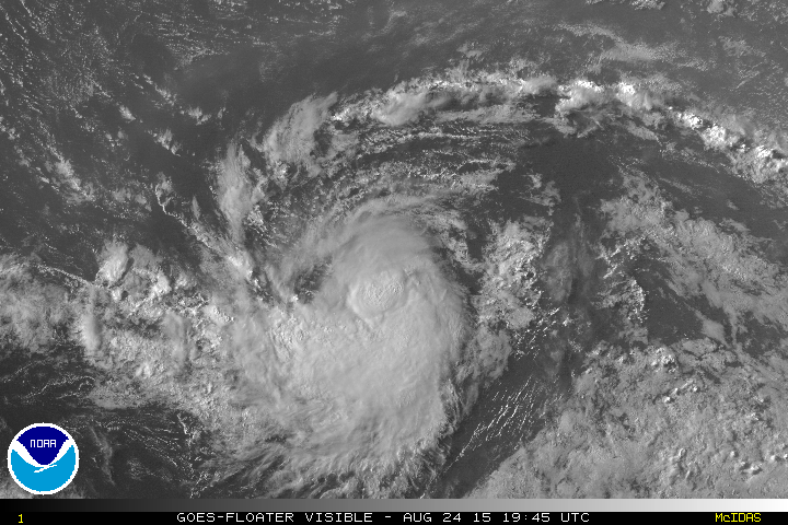
 |
| Zoomed-in view of 98L. |
The environment has not changed too drastically since Danny's trek last week, but even Danny was able to briefly attain Category 3 intensity! The latest ensemble of the global GFS model shows two general scenarios: the system remains weaker and tracks more toward the west, or it gets stronger and is more prone to recurve before even reaching the Leeward Islands. I advise against looking specifically at any single track here... it's just a single run from one model's ensemble. The idea is to just show patterns and trends. The tracks are color-coded by the intensity on this map.

This storm is moving twice as fast as Danny was, so even in its current location, it should reach the general area of the Leewards by Thursday.


 This storm is moving twice as fast as Danny was, so even in its current location, it should reach the general area of the Leewards by Thursday.
No comments:
Post a Comment