
The long-anticipated redevelopment of former-Hurricane Agatha is close to happening -- Potential Tropical Cyclone 1 is now centered near the northwestern tip of the Yucatan peninsula and already has tropical storm force winds, it's just lacking a well-defined surface circulation. Tropical storm warnings cover west Cuba, south Florida, and west Bahamas, but the primary concern is very heavy rainfall and flooding.

You can find long updating radar loops of PTC1 (future Alex) at http://bmcnoldy.rsmas.miami.edu/tropics/radar/
It is a sprawling and disorganized storm, with nearly all of the rain and thunderstorms displaced to the east of the surface circulation as a result of moderately strong westerly vertical wind shear. However, even as a low-end tropical storm, it is still capable of producing very heavy rain with significant impacts.
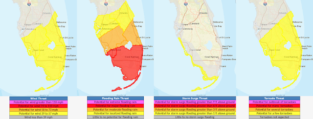
The categorization of a tropical cyclone (tropical storm, Category 1 hurricane, etc) depends only on the peak sustained wind speed in the storm, and contains no information about the other hazards or even the size of the wind field. A product that the National Weather Service has been creating operationally for every landfalling tropical cyclone since 2015 is called the "Hurricane Threats and Impacts" (HTI) graphics. These display the four hazards associated with tropical cyclones (wind, rain, storm surge, and tornadoes) on an interactive map using a four-tiered threat scale. The latest for south Florida is shown below, but you can also find them at https://www.weather.gov/srh/tropical.

In south Florida, the heaviest rain and strongest winds are expected to occur from the early morning hours on Saturday through midday Saturday, but conditions will gradually deteriorate/improve before/after then. At their strongest, winds could creep into low-end tropical storm force (sustained 40-45 mph with higher gusts), particularly along the immediate coastline. In low-lying areas, the tide cycle can make a difference in how well storm drains function, and on Saturday the high tides are at approximately 1am and 1pm, so heavy rain in the hours around then could be especially problematic. The western part of south Florida could experience minor storm surge flooding.
Once named, Alex will be the first named storm of the season, and will be the latest first named storm since 2014! Over the past fifty years (1973-2022), the median date of first named storm is June 19th, but there is definitely a trend to earlier in the year.

After Florida, PTC1 (Alex) is expected to strengthen some more, but remain over the water. However, it could bring heavy surf to the southeast US coastline, and have some impacts on Bermuda on Monday as it transitions to an extratropical cyclone.

- Visit the Tropical Atlantic Headquarters.
- Subscribe to get these updates emailed to you.
- Follow me on Twitter
No comments:
Post a Comment