The forecast beyond Thursday is extremely fuzzy with this, because 1) models don't generally handle disorganized tropical disturbances too well and 2) it will encounter Hispaniola on Thursday. This large mountainous island could be the end of something that barely got started (remember Erika in 2015?). Looking at the latest batch of ensemble tracks from the global model ensembles, we see none that reach hurricane intensity south of northern Florida. Members that stay further south and cross over more land stay very weak, while members that turn north are able to intensify more. For the south Florida concern: very few end up near south Florida, and among the ones that do, they are weak. If it were to reach south Florida though, it would be Saturday, or as late as Sunday morning.
Moving on to the suite of deterministic model runs, more of these pass south of the Bahamas and eventually travel roughly along the Florida peninsula. But, although not shown here, these are all tropical depressions or tropical storms the entire time.
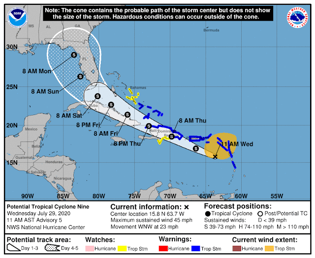
And to summarize everything, I'll wrap up with the official forecast from NHC. They have the unpleasant task of making a 5-day deterministic forecast for all the world to see. The tropical storm warnings (blue) and watches (yellow) are pretty straightforward, but the track and intensity forecast from Thursday onward is in their words "more uncertain than usual". Keep in mind that the size of the cone of uncertainty is fixed for every forecast of every storm all season long, so it does not reflect actual current uncertainty. Similarly, the intensity markers (D, S, H, M for Depression, tropical Storm, Hurricane, Major hurricane) do not reflect any intensity uncertainty.


No comments:
Post a Comment