A tropical disturbance is expected to form near Cuba or the southern Bahamas in the coming days... then drift across the northern Bahamas and potentially develop into a tropical or subtropical cyclone this weekend. If it earns a name, it would be Arthur, and 2020 would become the 6th consecutive year with a pre-season named storm.

As you can see in the chart above, the date of the first named storm in the Atlantic has decidedly been trending earlier over the past fifty years. This increases the odds of having pre-season (before June 1) activity. Since 1965, the bounds of the official Atlantic season are June 1 through November 30, but they were nudged around prior to that. There has been renewed debate regarding another nudge to the dates -- that's a topic for another day. Hurricane season was never intended to contain ALL activity, just the large majority.
Now on to the feature of interest, which doesn't exist yet. There has been agreement among global models of some sort of subtropical or tropical cyclone development over the Bahamas, but environmental conditions are marginal and the window of opportunity is brief. These forecasts from the most recent cycles of three global models are valid on Saturday evening, and are remarkably consistent with a weak but closed low pressure system over/near the northern Bahamas. Regardless of if it forms, it will track toward the northeast, away from land.
 |
| Forecasts of the low-level wind and surface pressure from the European (top), US (center), and Canadian (bottom) global models, all valid on Saturday evening. (tropicaltidbits.com) |
The primary impact from this in the U.S. will be elevated chances of heavy rain in the southern Florida peninsula on Thursday-Friday. There could also be higher surf all along the southeast US coast through Monday.
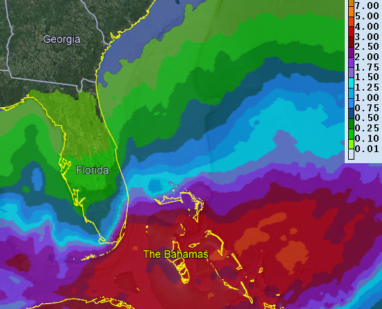 |
| Rainfall accumulation forecast through Sunday morning. (NOAA Weather Prediction Center) |
So, would it be subtropical or tropical if it forms? The difference is technical and purely academic, but since they are terms the public hears when storms are named and classified, what can it hurt to put this out there? The difference between the two types of cyclones is their structure: horizontal and vertical as well as thermodynamic and dynamic. Is the cyclone vertically aligned, are the strongest winds at the surface, are the strongest winds near the center, how deep is the cyclone, are there any frontal boundaries, etc, etc? So this next figure is technical, but the summary (from the U.S.'s global model) is that it is expected to be marginally tropical in nature, but hovering right around no man's land. Cyclone classification definitely has grey zones, since all of the defining parameters are on a continuous spectrum.
 |
| Cyclone phase space diagrams for the developing low pressure from the GFS model. Together, the two panels describe the key horizontal and vertical structure, both dynamically and thermodynamically. (Florida State University) |
- Visit the Tropical Atlantic Headquarters.
- Subscribe to get these updates emailed to you.
- Follow me on Twitter
No comments:
Post a Comment