08 July 2024

Hurricane Beryl makes its final landfall in Texas

After a 13-day journey from the west coast of Africa to the Gulf coast of Texas, Beryl made its final landfall early Monday morning near Matagorda, Texas as a Category 1 hurricane.  It was on a strengthening trend leading up to landfall, so thankfully it ran out of time before it could regain too much of its former intensity.


However, it is producing significant storm surge and flash flooding on Monday in Texas... this radar loop shows the few hours before and after landfall.  The full collection of land-based radar coverage of Beryl can be found at https://bmcnoldy.earth.miami.edu/tropics/radar/


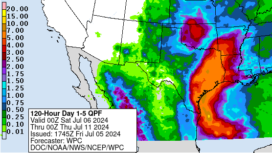
Beryl will continue to move inland... into northeast Texas, Arkansas, and beyond.  It will lose its tropical cyclone status but still be a major rain-maker along the way.


Beryl broke a lot of records related to where and when it formed, rapidly intensified, and achieved Category 3 and then Category 5 intensity.  It became the only Category 4+ hurricane on record to pass through the southern Windward Islands, and then it was the fifth Category 4+ hurricane to pass within 60 miles of Jamaica on record.

This type of incredible early-season activity is attributable to the record-warm water temperatures in the tropical Atlantic.  When Beryl formed, the sea surface temperature in the "Main Development Region" (MDR) was already warmer than it normally would be at the warmest time of year, and the ocean heat content in the same region looked like it normally would in mid-September.

We are likely going to see more extreme record-breaking storms this season as water temperatures continue to be very anomalously warm AND we transition to La NiƱa which generally acts to reduce vertical wind shear in the tropical Atlantic and therefore enhance hurricane activity.

In terms of ACE (Accumulated Cyclone Energy), Beryl has boosted the 2024 tally to an incredible level for so early in the season.  The ACE is higher than any other year on record by this date (even 1933), and is actually already higher than 14% of all entire hurricane seasons going back to 1851!  The ACE this season would finally meet up with the climatological value if no additional activity occurred through August 31.


05 July 2024

Tropical Storm Beryl about to enter Gulf of Mexico

After its very close and destructive encounter with Jamaica on Wednesday as a Category 4 hurricane, Bery weakened just slightly and tracked south of the Cayman Islands on Thursday at Category 3 intensity.  Then on Friday morning, it made landfall near Cozumel and Tulum at Category 2 intensity.  As of Friday afternoon, the intensity had decreased further to a tropical storm.


It will spend less than a day over land, then enter the Gulf of Mexico where it's expected to reintensify after the inland decay. How quickly it reorganizes will play a role in where it ends up for its final landfall.  A weaker storm exiting the Yucatan is more likely to stay further south, while a stronger storm is more likely to turn north, easily putting central Texas at risk... even eastern Texas has plenty of ensemble members near it.  At this point, the most likely still looks to be in the Brownsville to Corpus Christi span, but the trend has definitely been creeping northward, so keep a very close eye on updated forecasts.


As of now, there are no watches or warnings for the Gulf coast of mainland Mexico or Texas, but those should come later this evening or early Saturday.


And it's worth being aware that while the official forecast brings Beryl back up to Category 1 hurricane intensity by landfall, a stronger hurricane is not out of the question given Beryl's resilient and overachieving history. And as always, heavy rainfall will be a significant threat over a large area along the storm track:


I shared some preliminary NHC track and intensity verification stats on social media... spanning forecasts made through Friday morning:
Although NHC did correctly forecast rapid intensification, which is a notable achievement, Beryl blew past even those aggressive forecasts, so their intensity forecasts are overall biased low so far.  But the track forecasts have had very low error compared to their own 5-year average.

Looking at the Accumulated Cyclone Energy (ACE) so far this season, Beryl has contributed A LOT... more than any other season on record had by this date.  In fact, if Beryl disappeared right now and nothing else formed, 2024 would finally catch up to climatology on August 30!  (I wouldn't recommend betting that nothing will form until August 30.)


After Beryl, the basin looks quiet for a while.

03 July 2024

Beryl maintains Category 4 intensity as it hits Jamaica

Beryl has weakened from its peak 165 mph intensity, but not a lot... at 2pm EDT on Wednesday, the peak winds are still a hefty 140 mph... a Category 4 hurricane.  And that hurricane is hitting Jamaica on Wednesday afternoon before heading toward the Cayman Islands and then the Yucatan peninsula.


Vertical wind shear picked up noticeably on Tuesday, causing the storm to weaken only slightly and the satellite appearance to deteriorate a bit, but the ultra deep warm water in the Caribbean has given Beryl the boost it needs to overcome that shear.  The ocean heat content in the Caribbean has never been higher for this time of year, and looks more like the second week of September typically would.


Beryl's northern eyewall is scraping over the southern coast of Jamaica.  The radar in Jamaica has been inoperable for years, but there's a radar in Pilon, Cuba that is able to catch a glimpse of the eyewall over the mountainous terrain on Jamaica (so keep in mind you're seeing pretty high up by the time the radar beam is intercepting the eyewall).  As I write this, the western rainbands are just coming in range of the radar in Grand Cayman as well.  You can find these at https://bmcnoldy.earth.miami.edu/tropics/radar/


Jamaica only has three examples of Category 4+ hurricanes passing over/near it in the history books going back to 1851: Dean 2007, Ivan 2004, and Gilbert 1988.  So Beryl is only Jamaica's fourth encounter with a Category 4+ hurricane in at least 173 years.


The NHC forecast brings Beryl to the Yucatan peninsula on Friday, then somewhere along the Gulf coast on Sunday-Monday.  The intensity is very uncertain because each land interaction comes with its own unique set of weakening/reintensification scenarios.  In other words, you almost have to get past one to get a clearer picture of what you're headed to the next one with.


But, in 4-5 days, the track spread among global model ensembles spans the central Mexican Gulf coast through Texas and even into western Louisiana.  The highest clustering of tracks is near the US/Mexico border as of today.  In the maps shown below, the European model ensemble is on the left and the American model ensemble is on the right... in both cases, a similar spread exists, and they also both indicate that a stronger storm will be more prone to turn north, while weaker scenarios head straight west into Mexico.  Given Beryl's resilient history, one might be inclined to lean toward the stronger/northern solutions. 


Then, Invest 96L, the wave that's been tagging behind Beryl all along, is still struggling to develop, but there's occassional support in the models for eventual development in the Gulf of Mexico.  Far from a sure thing, but still something to pay attention to besides Beryl.  You can see its current appearance in the satellite loop at the top of the post; it just entered the eastern Caribbean, exactly in Beryl's footsteps.


02 July 2024

Running out of adjectives to describe Hurricane Beryl


Beryl has broken (at least?) two more incredible records in the past day: 
1) On July 2, it became the earliest Category 5 hurricane on record in the Atlantic, beating the previous date by fifteen days (Emily on July 17, 2005)
2) With 165 mph peak winds, it became the strongest hurricane ever observed during July, beating the previous strongest by 5 mph (also Emily on July 17, 2005).  It maintained that 165 mph intensity for six hours.  The infrared satellite image at the top of this post is from its peak intensity.

Beryl was first upgraded to a Category 5 hurricane on Monday night, and as of Tuesday afternoon, Beryl is just shy of that mark as an upper-end Category 4 hurricane.


However, the anticipated stronger vertical wind shear in the central Caribbean is beginning to take its toll on the storm's structure and some weakening is imminent.  It will pass south of Hispaniola on Tuesday evening, then approach Jamaica on Wednesday, bringing extremely destructive wind and storm surge to the island.  This will be the worst storm for Jamaica since Dean 2007 and then Ivan 2004 before that... so a very historic and devastating landfall (or near landfall) is coming tomorrow.

The radar in Jamaica has been inoperable for a while, but we will have some distant radar coverage from Cuba and then from Grand Cayman, which you'll be able to find at https://bmcnoldy.earth.miami.edu/tropics/radar/


As far as timing goes, the graphic below shows the probability of tropical storm force winds and their most likely time of arrival, at least through the end of the forecast period on Sunday morning.


It will reach the Yucatan peninsula on Friday morning and re-emerge over the Gulf of Mexico on Friday evening.  There's still uncertainty in the model guidance about how far north it might turn once it's in the Gulf... and at this point, anywhere from Mexico to Texas to Louisiana should be paying extremely close attention and taking preliminary precautions.  Although the current NHC forecast has it at tropical storm intensity in the Gulf, there is certainly model guidance that suggests it could be a strong hurricane again by its final landfall somewhere along the Gulf coast.


The system behind Beryl, Invest 96L, continues to struggle to organize and its formation probabilities are decreasing every day.  However, it will bring unwanted unsettled rainy weather to the Leeward Islands on Wednesday-Thursday... the same places that just got hit by a Category 4 hurricane on Monday.

01 July 2024

Beryl makes historic landfall in Windward Islands as Category 4 hurricane


Beryl continues its trek westward, and has now entered the eastern Caribbean.  The eye of the hurricane passed directly over the tiny island of Carriacou which lies between St. Vincent and Grenada in the southern Windward Islands.  The only other major hurricane that ever passed within 100 miles of Beryl's location on Monday morning was Ivan in September 2004, and that was at Category 3 intensity, making Beryl the first Category 4+ hurricane to pass through these islands in recorded history.  And again, it's only July 1.

It has actually intensified even more since yesterday, reaching peak winds of 150 mph on Monday -- nearly a Category 5 storm -- on July 1.  The previous earliest Category 4 hurricane was Dennis on July 8, 2005 (and the earliest Category 5 is Emily on July 17, 2005).


A long radar loop of the storm passing by Barbados is available at https://bmcnoldy.earth.miami.edu/tropics/radar/.

Beryl is unprecedented and record-breaking in several ways already, and it's only been around for three days.  Now it will spend the next 4 or so days in the Caribbean where the water temperature is as warm as (if not warmer than) what it would be at the peak of the season in mid-September.


Beryl is forecast to be near Jamaica on Wednesday, the Yucatan peninsula on Friday, then the southern Gulf of Mexico on Saturday.  Despite the extremely warm water ahead of it, some stronger vertical wind shear is likely going to knock the intensity down a bit by the time it gets to the central Caribbean in a couple days.  Once it enters the Gulf of Mexico, it's most likely going to continue westward, but there's some support in the model guidance for a gradual north bend which could potentially (though not likely) bring it into Texas.


The feature we've been tracking as Invest 94L was briefly upgraded to Tropical Storm Chris in the Bay of Campeche but has already moved inland into Mexico and dissipated.  It was a named storm for just 12 hours.

The easterly wave right behind Beryl, Invest 96L, has lower prospects for development now than in recent days.  NHC has dropped the odds of formation to 50%, and it looks very disorganized on Monday afternoon.

The next name on the list is Debby.