Zooming in on the eye, it's amazing to watch it quickly clear out after leaving Cuba -- Ian wasted no time re-intensifying and it's undoubtedly well on its way to becoming a Category 4 hurricane.
Ian has been in continuous radar coverage since Sunday morning, and you can find the archived and current radar loops at http://bmcnoldy.rsmas.miami.edu/tropics/radar/. This view shown below is a mosaic of many radars to create a regional-scale image.
It has now been 12 days since Ian left the African coast as an easterly wave, and 4 days since it became a tropical cyclone. Now the final days are here, and they are extremely impactful. Tropical storm, hurricane, storm surge, flood, and tornado watches and warnings plaster nearly all of Florida and even into Georgia and South Carolina.
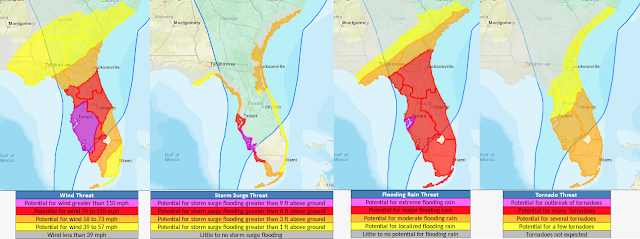
The Tuesday afternoon suite of Hurricane Threats & Impacts (HTI) graphics are shown here. These break the hurricane down into its four hazards (wind, surge, rain, and tornado) and provide relative threat levels from each hazard. As you can see, the entire peninsula will experience impacts from Hurricane Ian, but the worst is focused on the central part of the west coast. If you are anywhere that's covered by a threat in red or purple, be prepared for some serious and even life-threatening impacts from the corresponding hazard.
As far as winds go, tropical storm conditions will gradually work their way northward along the peninsula, beginning with Key West this afternoon, and wrapping up around Jacksonville on Thursday morning. Although not shown here, the hurricane's large wind field will amplify coastal flooding issues on the east and west coasts... water levels were already running high because of the new moon and time of year. The storm surge near landfall is quite different; that is far more dire and life-threatening than elevated tides elsewhere in the state.
Between the landfall in Cuba and then in Florida, there's little doubt that the name Ian will be retired after only its second use (it replaced Igor in 2016). This would make it the 13th "I" name to be retired since tropical cyclones were given names in the Atlantic, by far more than any other letter. To make the "Curse of the I" more complete, it's also in September and it's also likely going to peak at Category 4 intensity -- all three of these traits reinforce the existing leaders of retired names.
- Visit the Tropical Atlantic Headquarters.
- Subscribe to get these updates emailed to you.
- Follow me on Twitter
 As expected, Ian rapidly intensified and became the season's second major hurricane on Tuesday morning. (A "major hurricane" is simply defined to be a Category 3+ hurricane on the Saffir-Simpson Scale). It crossed the western tip of Cuba and the eye is now back over water. It is forecast to make landfall in the Tampa area as a Category 3-4 hurricane on Wednesday night.


No comments:
Post a Comment