28 November 2022

It doesn't take an active hurricane season to be a devastating one

This post marks the end of my 27th year writing these updates on tropical Atlantic activity.  During that time, I have written approximately 1380 posts spanning 460 tropical cyclones, 205 hurricanes, 94 major hurricanes, and 51 retired storm names. I know some of you reading this have been following along the entire time, but whether you've been reading these posts for 27 days or 27 years, I truly appreciate your continued interest!

The 2022 Atlantic Hurricane Season ends on Wednesday the 30th, and although it was much less active than initially expected, it definitely left its mark.

Track map of all sixteen tropical cyclones that formed during the season.  The storm's peak intensity and lowest central pressure are listed next to the names.

The season included 14 named storms, 8 of which became hurricanes, and 2 of those became major hurricanes.  Climatologically, those numbers are 14, 7, and 3.  But of course there's more to a hurricane season than the number of storms.

A commonly-used metric is the Accumulated Cyclone Energy, or ACE, and that is better at describing the overall duration and intensity of storms rather than the number of storms.  This season ended up with just 80% of an average season's ACE... the lowest since 2015.  


The distribution of activity was very unusual.  July and August were dead (with the exception of Colin which was around for a few hours on July 2 over land), while November ended up as the second-most-active month of the season.  On average, 22% of the season's ACE is accrued during August; this year it was 0%.  And 47% of the season's ACE historically occurs during September; this year it was 80%.

Of the fourteen named storms, four of them accounted for 74% of the total ACE and the other ten made up the remaining 26%.  The top four were Fiona (28%), Ian (18%), Earl (15%), and Danielle (13%).

This November was only the fourth on record to feature three hurricanes, the others were 2001, 1887, and 1870.  But two of the three were active simultaneously and the only other times that happened were 2001 and 1932.

On the flip side, this was only the fifth time since records began in 1851 that August went by with no activity; the last time was 1997.  But 1997 was during a strong El Niño -- this was the first August with no tropical cyclone activity during La Niña on record. Truly a bizarre season.

All other things being equal, La Niña acts to enhance Atlantic tropical cyclone activity... and La Niña has effectively been in place since the middle of 2020.  So what caused August to be so inactive even when it had that favorable background state?  There were three factors that all played a role, though their origins are not yet clear to me.  The mid-levels of the tropical and subtropical atmosphere were extremely dry, there was enhanced vertical wind shear over the tropical Atlantic, and the sea surface temperatures were anomalously cool over the tropical Atlantic.  They combined to overwhelm and suppress anything that tried to form.  Conditions quickly returned to normal once September began and then Danielle, Earl, Fiona, Gaston, Hermine, and Ian all formed during September.

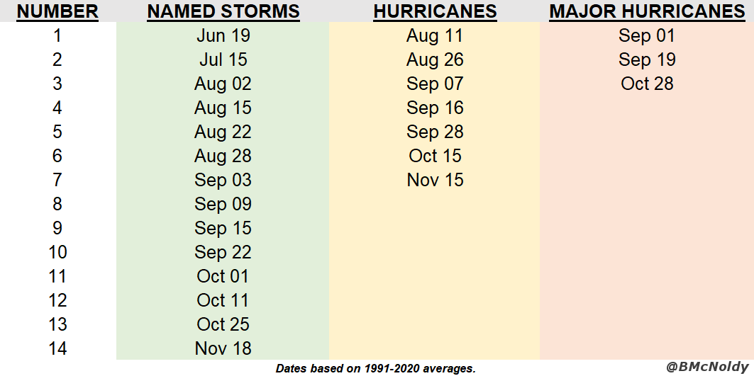
For the first time since 2014, the first named storm formed after June 1, the official beginning of the Atlantic hurricane season.  Even so, it formed a couple weeks earlier than average.  The chart below shows the date of first named storm formation over the past fifty years in blue... the cyan line is the beginning of hurricane season (June 1), the magenta line is the median formation date (June 19), and the dashed gray line is the linear trend through the dates.  There's a lot of interannual variability, but for a variety of reasons, this trend is decidedly getting earlier.


The most intense storm of the season as measured by peak wind speed was Ian, but Fiona had the lowest central pressure, the highest ACE, and the longest duration as a named storm.  Ian also tops the list as the season's most deadly and most destructive.  In a few months, the World Meteorological Organization's tropical cyclone committee will convene and debate which names should be retired from this list.  Factors generally include how deadly and how destructive a storm was.  Using preliminary numbers, the top five deadliest storms this season were Ian, Julia, Hermine, Fiona, and Nicole... the top five costliest storms were Ian, Fiona, Nicole, Julia, and Hermine.  The same five storms made both lists but are just ranked differently.

Six countries experienced a hurricane landfall this season: Nicaragua (Julia), Belize (Lisa), Cuba (Ian), Dominican Republic (Fiona), United States (Ian and Nicole), and Canada (Fiona).  Fiona was technically not a hurricane when it reached Nova Scotia, but was a Category-2-equivalent extratropical cyclone.  Fiona also didn't technically make landfall in Puerto Rico, but passed close enough to deliver a crippling deluge of rain that was extremely destructive and killed over two dozen people.  Although the the final counts are not yet known everywhere, there were approximately 350 people killed by tropical cyclones across the Atlantic during the 2022 season.

Finally, here is a preliminary look at how the National Hurricane Center's forecasts of track and intensity matched up against their own average errors over the previous five seasons.  The track forecasts were very good this season, beating their average error at every forecast lead time.  Out at five days (120 hours), the storm that made the greatest contribution to the errors was Gaston.


Moving to intensity, the forecasts were better than average out to three days (72 hours), then slightly worse at four days (96 hours) and noticeably worse at five days (120 hours).  Those 4-and-5-day errors were dominated by Fiona.


There are several radar animations of the storms near land from this past season, from Alex to Nicole... all are available at https://bmcnoldy.rsmas.miami.edu/tropics/radar/

The 2023 hurricane season is six months away, and the list of names begins with Arlene, Bret, and Cindy... the list that was first used in 1981 and every six years since then.  However, quite a chunk of the list has been retired and replaced:
1981: no names retired
1987: no names retired
1993: no names retired
1999: Floyd, Lenny
2005: Dennis, Katrina, Rita, Stan, Wilma
2011: Irene
2017: Harvey, Irma, Maria, Nate
2023: TBD


09 November 2022

Nicole set to make Florida landfall on Wednesday night

Tropical Storm Nicole is crossing over the northern Bahamas midday Wednesday, and is headed for the southeast Florida coast late Wednesday night, perhaps as a Category 1 hurricane.  If it does end up being a hurricane at landfall, it would be just the second hurricane to make landfall in south or central Florida during November in historical records... the one and only previous one was in 1935.


I have several updating radar animations that cover the Bahamas, eastern Florida, and there is one that will be longer and covers the US east coast: https://bmcnoldy.rsmas.miami.edu/tropics/radar/.  An example from the Bahamas is shown here.


Nicole is a very large storm, so heavy rain and stronger winds will arrive at locations long before the center is anywhere close, and those conditions will last longer too.  As of Wednesday morning, tropical storm force winds extend as far as 460 miles from the center.  It's forecast to travel northward along the east coast, dropping heavy rain along its path, and causing coastal flooding along the way too.  Although it will lose its tropical classification, it will still be capable of producing significant impacts!

One key point that seems like it can't be made too often is that the track forecast cone (a.k.a. "cone of uncertainty") is not used to show where impacts will be experienced.  Clearly, the vast majority of impacts are outside of the cone.  Never use the cone to determine what hazards you will be exposed to.


Impacts will be far-reaching, primarily in the form of flooding from heavy rain and storm surge-induced coastal flooding... winds will of course be fairly strong, but generally not very destructive.  This set of Hurricane Threats and Impacts (HTI) graphics is valid through midday Friday, and you can see the distribution and threat level of the various hurricane-related hazards: wind, surge, rain, and tornado. 


The rest of the Atlantic is quiet, so once Nicole is no longer tropical in a couple days, maybe that will be it for the season... maybe.  The Accumulated Cyclone Energy (ACE) is at about 79% of average for the date.


07 November 2022

Nicole forms north of Hispaniola, big impacts expected along southeast US coast

The disturbance I mentioned in Saturday's post was upgraded to Subtropical Storm Nicole early Monday morning.  This is the season's 14th named storm, which is the average number during a full season.


As a bit of an introduction, there are three classifications of cyclones based on their structure, energy source, and other factors: tropical, subtropical, and extratropical.  Those approximately correlate to the latitude bands in which they exist, but there's a lot of overlap... and even the classification can be tricky because the boundaries between the classifications are continuous, not discreet.  Anyway, a subtropical storm doesn't look like the classic symmetric, compact thing we associate with a tropical storm, but the impacts can be the same.  In other words, don't downplay a storm just because it's labeled "subtropical".


Nicole is presently centered about 450 miles north of Hispaniola, and 650 miles east of Miami, Florida.  The wind field is very large, but also very lopsided (that's part of the subtropical classification).  It is expected to transition to a tropical storm by Wednesday, and that means it should become more symmetric, but the wind field will still be expansive.

As always, do NOT use the "cone of uncertainty" for anything other than uncertainty in the track forecast. Notice that right now, almost the entirety of tropical storm conditions (the orange blob) is outside of the cone.


And it's that expansive wind field that is the big problem in the coming days.  We are looking at several days of significant coastal flooding from North Carolina to Florida from the storm, but then we also have already-high tides for a few days around Tuesday's full moon.  This is going to be a big deal, so it shouldn't be underestimated because it's "only" a tropical storm.  The animation below is a forecast of significant wave height (shaded contours), surface wind (maroon barbs), and swell direction (green arrows).

This product is updated every six hours; you can find the most recent at http://bmcnoldy.rsmas.miami.edu/wavewatch/

Tropical storm watches are in effect for extreme southeast and northeast Florida, with hurricane watches for the northern Bahamas and central and south Florida (from Broward County north).  Based on the 10am EST forecast, the tropical storm wind speed probabilities and earliest reasonable time of arrival are shown below.  


The ensemble spread in track forecasts spans from the Florida Keys to Cape Canaveral, with the most likely in the West Palm Beach area.  Impacts will be worse north of the center, and not as bad south of the center, so if it does end up making landfall in the West Palm Beach area, Miami and Fort Lauderdale would fare much better than places like Melbourne, Daytona, and Jacksonville.


Finally, in addition to the widespread threat of tidal flooding, Nicole will deliver a long swath of heavy rain from Florida up to New England over the next five days.


05 November 2022

Watching disturbance near Hispaniola for impacts in Florida

For several days, models have been hinting at the formation of a low pressure system east of the Bahamas, near Hispaniola and Puerto Rico.  That has finally happened, so it's time to take it seriously... the odds of this becoming a subtropical or tropical cyclone in the near future are high.


It's nothing but a large area of thunderstorms now, but models are abnormally confident about it developing and heading toward Florida by mid-week. We don't have any of the high-resolution hurricane-specific models available for it yet, so we have to rely on the global models and their ensembles.

From the latest cycle of the American and European ensembles, these are the tracks and positions of the low pressures on Thursday morning.


Then, switching to the deterministic runs from the same cycle, these are the surface pressures and winds valid on Wednesday evening.  Don't ever take the details of a 108-hour forecast literally, but these give you an idea of what the two models are doing.


Clearly there's a big difference in intensity, but they agree remarkably well on *something* reaching south-central Florida on Wednesday-Thursday.  Whatever it is by then, it will undoubtedly dump several inches of rain on the area.  The GFS solution is actually a Category 1-2 hurricane when it reaches the southeast Florida coast, so although not likely, it's not out of the question either.

Also notice the structure of it: it looks likely that the stronger winds (and heavier rain) will be north of the center, not symmetric like a classic tropical storm or hurricane.  

One final and significant impact to mention is widespread and prolonged coastal flooding.  The winds from this storm will be conducive for onshore flow from the Carolinas down to Florida, then you combine that with already-elevated tides for a few days around Tuesday's full moon, and there could be hundreds of miles of coastal flooding from Monday through Thursday.

Elsewhere, there's a strong low pressure system located east of Bermuda, tagged as Invest 97L.  This could also develop into a subtropical or tropical cyclone in the near future, but will innocently track off to the northeast into the north-central Atlantic.


The next two names on the list are Nicole and Owen.


02 November 2022

Two simultaneous hurricanes... in November

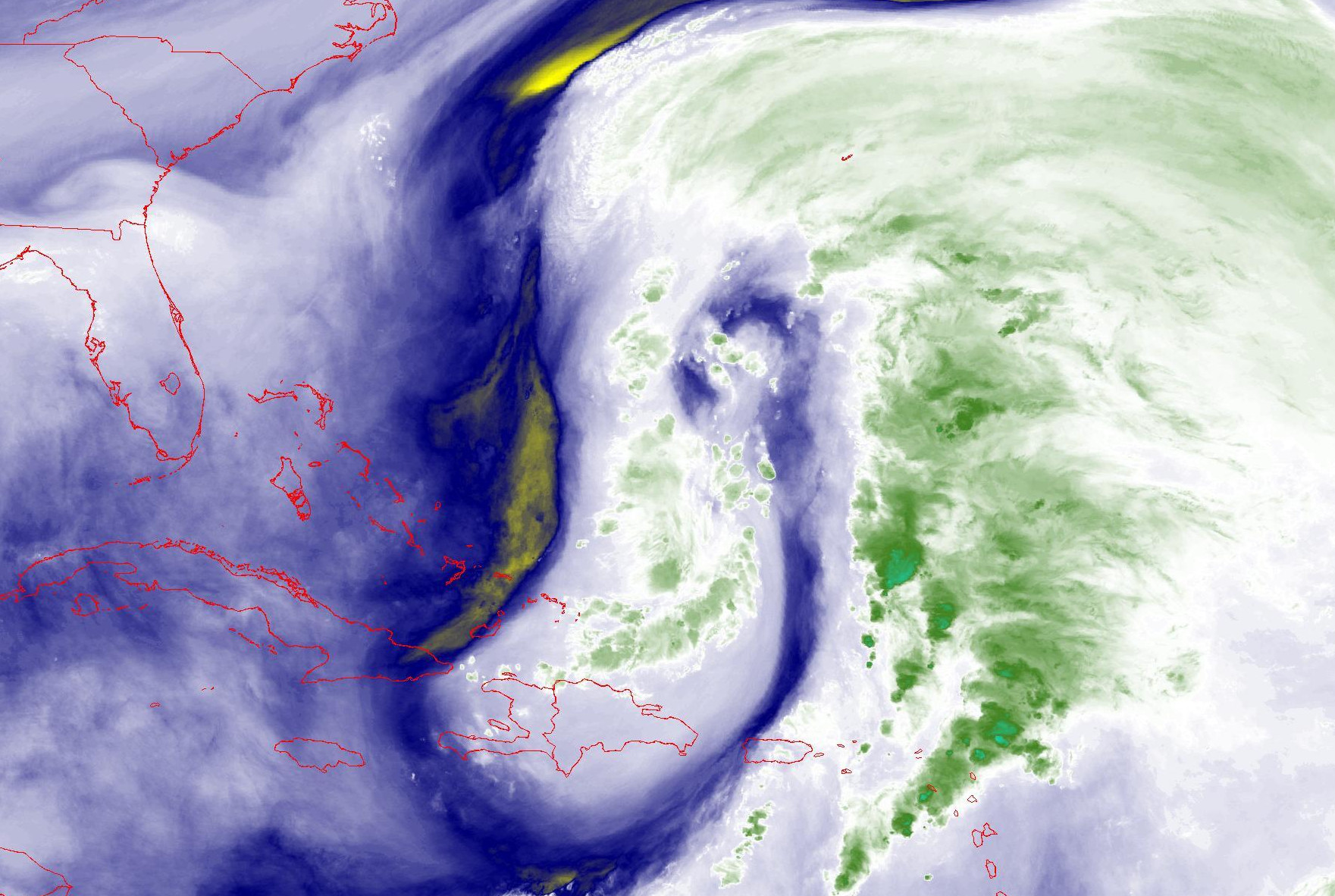
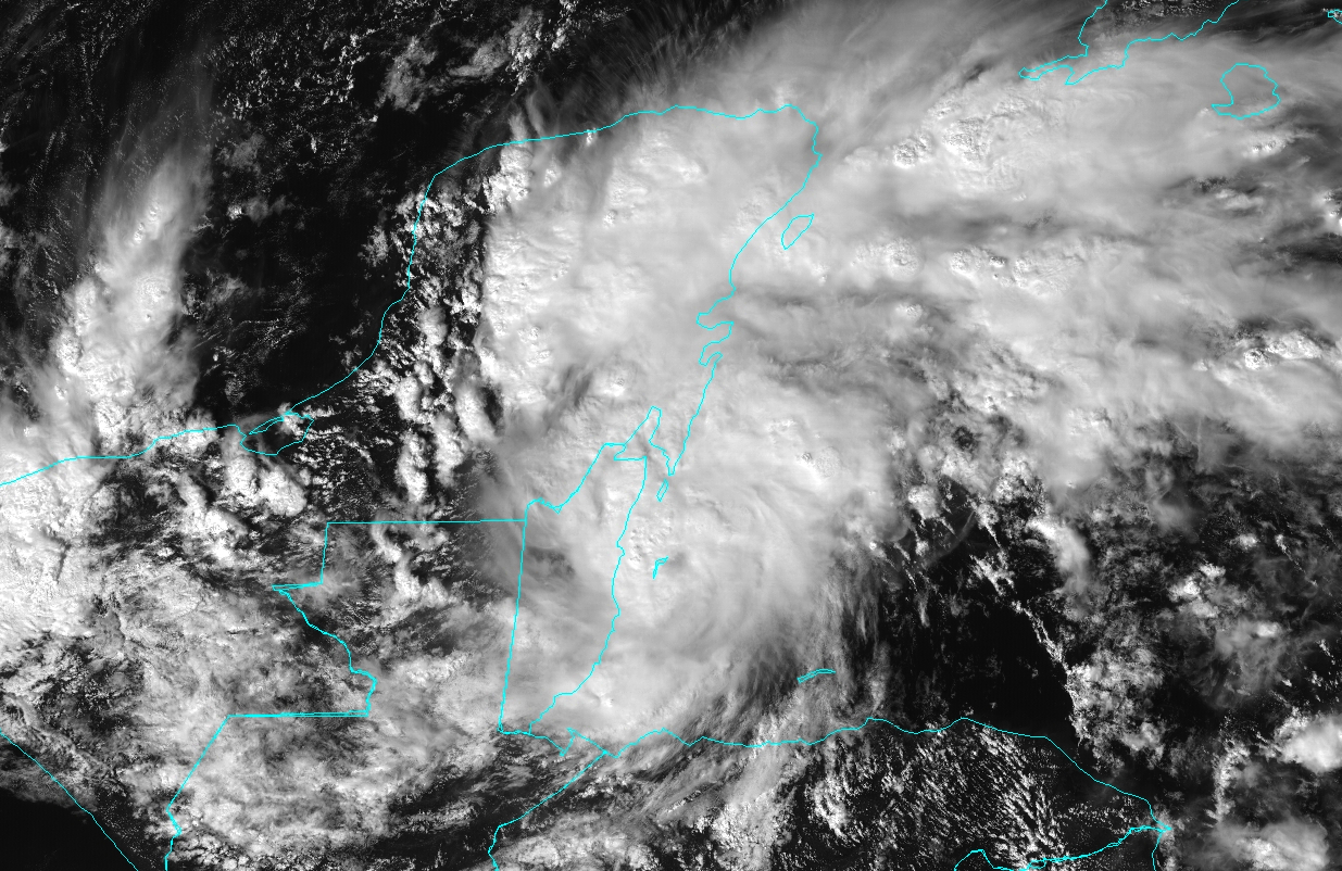
As eluded to in yesterday's post, both Lisa and Martin did indeed become hurricanes on Wednesday, and they're both active at the same time.  This would not be too noteworthy in the core months of August, September, or October, but it's absolutely exceptional in November.  In fact, it's only been observed twice before: in 2001 and 1932.

Lisa is going to make landfall in Belize as a Category 1 hurricane on Wednesday afternoon, that country's first such landfall since Nana in 2020.


Once it makes landfall it will quickly weaken, but produce significant rainfall over Belize, Guatemala, and southern Mexico before what's left of it moves back out over the Bay of Campeche.  The National Hurricane Center's forecast indicates a weak tropical depression moving out into the bay, then turning back to the southeast and dissipating over Mexico.


Martin is flourishing in a brief window of favorable conditions, but it is expected to transition to a strong extratropical cyclone sometime on Thursday as it travels over increasingly cold water.


In the forecast map below. the white-filled forecast positions mean that it will not be a tropical (or subtropical) cyclone anymore. 


It's worth a quick mention that the two examples of the "cone of uncertainty" shown in this post from Lisa and Martin are identical in size and in their construction.  All storms during the entire hurricane season have the same "cone" whose size is determined by track errors over the previous five seasons.  For a full refresher on this, please visit 2022 "Cone of Uncertainty" Update & Refresher.

This mini burst of activity has provided a small boost to the season's total Accumulated Cyclone Energy (ACE), which is now at about 77% of average for the date.  Within 24 hours, both Lisa and Martin will likely no longer be contributing to the ACE tally.  In terms of storm numbers, the season has had 13 named storms, 7 hurricanes, and 2 major hurricanes... the climatological average for a full season is 14, 7, and 3. 


01 November 2022

November kicks off with Tropical Storm Martin as Lisa strengthens

Let this be a lesson in model confidence: one day ago Tropical Storm Lisa's prospects for intensification were not too high, and the rest of the Atlantic looked pretty quiet with just low chances of formation near Bermuda (I didn't even bother mentioning it).  Today, Lisa is a strengthening mid-range tropical storm and Tropical Storm Martin formed well east of Bermuda.


Although Lisa is still battling some westerly wind shear, the appearance is drastically more symmetric compared to yesterday, so the dry air I mentioned did not sneak into the circulation as much as expected, and the extremely warm ocean helped to give it a kick.

Lisa is still expected to make landfall in Belize on Wednesday evening, and the odds of it reaching hurricane intensity prior to then are higher now... several more dynamical models are on board with that scenario.  It could re-emerge over the Bay of Campeche on Friday-Saturday, but the model guidance is really scattered on how it evolves after a couple days over land.

The last few hurricanes to make landfall in Belize were Nana (2020), Earl (2016), and Richard (2010).

Martin, the season's 13th named storm, has been a trackable feature for several days now, but looked fairly benign and the models were not too bullish on it.  But in the past day it really got organized in a hurry and is a bona fide tropical cyclone.  


It too could become a hurricane in the near future, but its time is limited before it transitions to a potent extratropical cyclone over the far north-central Atlantic.

Martin is a new name in this list, replacing Matthew which was retired after the 2016 season.


Climatologically, the season's 13th named storm forms on October 25, so this is just a week behind that average date.  There have been five hurricanes so far this season, so if Lisa AND Martin make it, that would bring the total up to seven which is the average number during a full season.


31 October 2022

Season's 12th named storm forms on Halloween

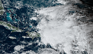
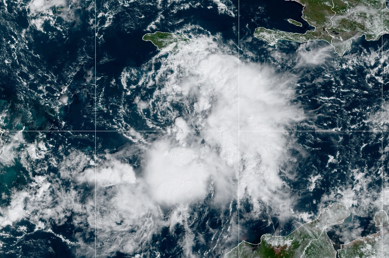
Tropical Storm Lisa formed today in the central Caribbean, just south of Jamaica.  This has been a feature of interest for about six days already, but it failed to develop near the Lesser Antilles and the eastern Caribbean. Even today, it looks marginal on satellite, but aircraft data confirmed the organization and intensity necessary to upgrade it to a tropical storm.


Despite the extremely warm ocean water in the western Caribbean, Lisa continues to face some environmental challenges to intensification.  There's quite a bit of dry air to the west, and some of that is wrapping into the circulation now and will continue to linger.  The storm is also in fairly strong vertical wind shear as evident in the satellite animation above -- the low-level center is completely exposed and the thunderstorm activity is all displaced to the east and south.  

Over the next couple of days, the shear is expected to relax somewhat, and that in turn will reduce the amount of dry air that reaches the storm center.  This 3-day forecast from the American GFS model shows the mid-level humidity in the colored shading, and it illustrates the gradual moistening of the storm environment before it makes landfall.


The model guidance is fairly clustered on the track, but more scattered on the intensity.  For track, Lisa will continue to head west across the Caribbean, reaching Belize midday Wednesday.  For intensity, the large majority of models keep it as a tropical storm, but there's an outside chance that it could reach hurricane intensity prior to landfall.  The official forecast (as of 11am EDT) is on that high end and indicates a minimal Category 1 hurricane at landfall... if model trends continue to drop, the subsequent NHC forecasts will certainly reflect that.


Lisa is the season's 12th named storm... you have to go back to 2015 to find so few storms by the end of October, and in terms of Accumulated Cyclone Energy (ACE), the season is at about 73% of average for the date.


Elsewhere, the Atlantic is quiet and there's no sign of new development within the next week or so.


12 October 2022

Karl forms and threatens Mexico with heavy rain

First, a bit of catching up: I was on vacation last week and didn't write anything about Hurricane Julia which formed near Aruba, tracked west and developed into a hurricane as it made landfall in central Nicaragua, and then had a complicated evolution over Central America.

Like Bonnie back in early July, Julia made landfall in Nicaragua and traversed the country intact, maintaining its identity as a tropical storm in the East Pacific.  Julia made another landfall in El Salvador then dissipated over Guatemala, but a part of the circulation split off to the west and is an area of potential development (Invest 99E) in the East Pacific while another part split off to the north and became Tropical Storm Karl on Tuesday afternoon.


The map above shows an infrared satellite image from Wednesday morning, but I superimposed the tracks of Hurricane Julia, Tropical Storm Karl, and Invest 99E for reference to illustrate the interesting split that Julia's remnants experienced.

Julia was the season's 10th named storm and 5th hurricane, so Karl is the season's 11th named storm -- it is not expected to reach hurricane intensity as it drifts back south into the Veracruz area of Mexico over the next couple days.  The greatest threat is heavy rain resulting in flooding and mudslides.


The season's storm tally as of October 12 is at 11 named storms, 5 hurricanes, and 2 major hurricanes (Category 3+).  This table shows the average dates by which these milestones occur... you can see that by now, an average season would have 12 named storms, 5 hurricanes, and 2 major hurricanes, so 2022 is really close to those marks.


We can also look at the season's activity in terms of Accumulated Cyclone Energy, or ACE, which is a metric that doesn't depend on the number of storms, but on the overall intensity and duration of whatever storms there are.  By this metric and the same baseline as before (1991-2020), the season is only 79% of average for the date.


Elsewhere, the Atlantic basin is quiet with no activity in the foreseeable future.

30 September 2022

Ian's third and final landfall in South Carolina


Fifteen days after leaving the African coast, Ian's last few hours are here.  It became a tropical depression on the 23rd, made landfall in western Cuba as a Category 3 hurricane on the 27th, then in central Florida as a Category 4 on the 28th, and now in South Carolina as a Category 1 on the 30th.


Although Ian is on the cusp of becoming an extratropical cyclone, it still poses the same threat (remember Sandy in 2012?).  It's a Category 1 hurricane with 85 mph peak sustained winds, and made landfall between Charleston and Myrtle Beach on Friday afternoon at about 2pm local time.  Ian will dissipate over the Carolinas and Virginia in the next day or so, and after dropping a few inches of rain over those areas, that will be the end of it.


Storm surge was and is the primary threat today, and some areas have definitely experienced severe coastal flooding today.


There is another wave of interest just moving off the African coast today.  Like Ian, it's coming off at a very low latitude, but unlike Ian, it's likely to turn to the northwest within a week.  After that, there's some divergence in the model guidance so it's just something we'll need to keep an eye on now and then -- it's very far from any land.  If it becomes a tropical storm, the next name is Julia.


September was extremely active... of the nine named storms so far this season, six of them formed in September.  In terms of ACE, September accounts for 94% of the total at this point, two-thirds of the way through the season.  And compared to the average over the past fifty years, 2022 is now at 97% of the average value for the date.


As of Friday afternoon, these next two images show the history of NHC forecasts for Ian: track on top then intensity below.  The observed track and intensity is the thick black line, and each six-hourly forecast is shown by a colored line.

As it relates to the Florida landfall, the "cone of uncertainty" always contained the eventual landfall point... every advisory for all five days from Ian's formation on the 23rd to its landfall on the 28th.  The cone is designed to show where the center of the storm should track, with 2/3 likelihood.  Having that long to prepare for what was forecast to be a major hurricane landfall is very good, but it doesn't stop the damage from happening, unfortunately.  All people can do is get out of its way.