31 August 2011

Katia intensifies, could become hurricane later today

Katia is still a tropical storm, but the central pressure has fallen 9mb in the past 24 hours... certainly not rapid by any measure, but on a decidedly strengthening trend.  The maximum sustained winds are estimated at 55kts as of the 15Z advisory, and additional (substantial) intensification is expected.
Forecast models are in excellent agreement on a continued WNW track for the next 5 days, which brings it near the northern Leeward Islands.  Beyond that, there is some divergence... with the majority recurving it well off the US east coast (perhaps bad news for Bermuda) and a minority bringing it very close to the US east coast.  There is plenty of time to refine the forecast track before it's a thread to any land.

The disturbance I mentioned in the western Caribbean continues to simmer, now near the northern tip of the Yucatan peninsula. 

Many models slowly develop this as it heads NW into the Gulf of Mexico, then by this weekend into next week, have it stall off the TX/LA coast... perhaps strengthening as it sits there.  Definitely something to keep an eye on.  The image below shows the total precipitable water (TPW... the total amount of water in an atmospheric column if it all condensed out), and the large envelope of high values surrounding this disturbance.  An environment of very moist air is healthy for tropical cyclones, both young and old.


Please visit my tropical Atlantic headquarters.

30 August 2011

Tropical Storm Katia forms in far eastern Atlantic

At 09Z today (5am EDT), TD12 was upgraded to TS Katia, the 11th named storm of the season, based on satellite presentation.  The 15Z intensity estimate is 40kts, with a 1003mb central pressure. It's centered near 12N 34W, or roughly 1800 miles east of the Lesser Antilles, and heading WNW at 16kts.

Katia is forecast to intensify fairly quickly, reaching Category 3 status within 5 days as it approaches the Leeward Islands.  The WNW motion is expected to continue, bringing it near 20N 60W by Sunday morning.  In 8-10 days from now (late next week), it could be on a similar track to Irene or perhaps further east over the ocean, so it will of course be watched very closely.  The graphic below shows the forecast intensity and track of the storm, as well as the vertical shear, SST, and RH in the storm's environment (left of the vertical lines is in the past, right of the vertical lines is the forecast... from the various models listed in the legends).  You can find the latest version (and full size) of this at http://rammb.cira.colostate.edu/products/tc_realtime/storm_model_data.asp?storm_identifier=AL122011

Climatologically by this date, we would have 4 named storms, 2 hurricanes, and 0 major hurricanes.  We are currently at 11, 1, and 1.

Elsewhere, there is a very slow-moving easterly wave festering in the western Caribbean that warrants attention.  Many models favor this for development, with a VERY gradual track toward the TX/LA coast; possible Gulf coast landfall in the middle of next week... IF it develops.

Please visit my tropical Atlantic headquarters.

29 August 2011

Irene and Jose dissipate, TD12 forms

The final advisory was written on Irene at 03Z today, located north of Maine and still producing heavy rain in eastern Canada. As of this writing, Irene is blamed for at least 24 deaths, tens of billions of dollars in property damage, major disruptions to the nation's transportation network, and about 3 million people without electricity.  The radar/raingauge precip totals during Irene's passage are shown below.  There are values approaching 20" near Albany NY, Suffolk VA, and Greenville NC, but very heavy totals from NC into northern New England resulted in widespread flooding.  The governor of Vermont summed up the weekend for many areas: "We prepared for the worst and hoped for the best and unfortunately got delivered the worst".


All of the radar loops that I've made for Irene can be found at http://einstein.atmos.colostate.edu/~mcnoldy/tropics/atlantic/ (News & Updates section, or in the CSU Atmospheric Science section).  This includes coverage from San Juan PR, Miami FL, Morehead City NC, Dover DE, and New York City NY.

The odds of the name Irene being retired are high, which would make it the 7th "I" storm in the past 11 years to be retired (joined by Iris, Isidore, Isabel, Ivan, Ike, Igor).  Quite unusual!

Short-lived TS Jose has already dissipated after being a named storm just a day.  It formed southwest of Bermuda and the remnants are now north of Bermuda.

The easterly wave that I mentioned yesterday is now near 28W and was upgraded to TD12 at 09Z this morning.  The environment should improve in the coming days, mostly in the form of decreased vertical shear.  The majority of models are quite aggressive in developing this, and it will likely become our next tropical storm and hurricane: Katia.


One additional tidbit: today is the 6th anniversary of Katrina's final landfall in LA.  The next name on this season's list, Katia, is the replacement name after Katrina was retired.

Please visit my tropical Atlantic headquarters.

28 August 2011

Irene near NYC, Jose near Bermuda, new wave near Cape Verdes

Since yesterday, Irene has been downgraded to a tropical storm with 65kt winds, and the center has just passed over New York City.  The rain shield is almost entirely on the north half of the storm, so from southern NY up into Canada there is widespread heavy rain, but south of there, coverage is pretty minimal.  Without going into immense detail from all possible locations, Irene has already been blamed for 10 deaths, and extensive coastal erosion and flooding in much of mid-northern Atlantic states.  It will be easier to summarize the rainfall amounts once it's done raining.  Here is a composite radar image showing the extensive rainfall as of 10am EDT this morning:

There is extensive flooding in Lower Manhattan, Philadelphia, the list goes on.  And, for those of you without power, or with a flooded basement/business, etc, just remember that this hurricane was a blessing, according to Glenn Beck.  (http://religion.blogs.cnn.com/2011/08/27/glenn-beck-hurricane-irene-is-a-blessing/)  Sorry, couldn't resist tossing that in.   If anyone cares to share stories or photos from Irene, I'd be happy to share them on here for you!

For some additional tidbits on Irene, check out this NYT article: http://www.nytimes.com/2011/08/28/us/28hurricane-irene.html

Earlier this morning Tropical Storm Jose formed on Bermuda's doorstep, prompting short-fuse warnings.  The intensity is 35kts, but is forecast to weaken.  It's located 100 miles southwest of Bermuda and heading north at 14kts.  This is a small weak system, but you can see the circulation on Bermuda's radar: http://www.weather.bm/radarLarge.asp

Elsewhere, another vigorous easterly wave exited the African coast yesterday (early on the 27th).  It's centered near 22W, and forecast to develop fairly quickly as it heads WNW over the next several days.  It's no immediate threat to anyone, and the next name on the list is Katia (replaces Katrina from 6 years ago).


Please visit my tropical Atlantic headquarters.

27 August 2011

Irene makes first US landfall in NC

At about 12Z today (8am EDT), Irene made landfall near Cape Lookout, NC as a Cat 1 hurricane.  The radar image from the approximate time of landfall is shown here.

The northeast is still in the crosshairs, and although Irene is weakening, that will only minimally affect the storm surge and not affect the rainfall...  the category rating is only for wind, not water (though a stronger storm will generally generate a larger storm surge).  The Chesapeake Bay, Delaware Bay, Long Island Sound, and all inlets, bays, and sounds along the northeast coast should still be ready for some major flooding.  The latest storm surge model output for the northeast metro areas is shown below:
And, in addition to this, the entire northeast can expect huge amounts of rain in the next 36 hours.  The graphic shown here is the forecast accumulated rainfall over the next 3 days (in inches).  This will be a very historic storm, even if it's only a tropical storm by the time it reaches New York!  As of this update, the rain is already beginning to fall as far north as CT and RI, including VA, PA, DE, MD, NY, NJ.  As the storm progresses, you will be able to find current and additional long radar loops at http://einstein.atmos.colostate.edu/~mcnoldy/tropics/atlantic/

Please visit my tropical Atlantic headquarters.

26 August 2011

Irene forcing evacuations in nine states

Hurricane Irene has weakened a bit more this afternoon in terms of maximum sustained wind speed in the core, but as I mentioned earlier, the main threats are the storm surge and the rain... the exact intensity should not be the focus when it comes to preparations and evacuations.  At 21Z today, the maximum sustained winds were 85kts, making it a Cat 2 storm.  It is located 265 miles south of Cape Hatteras NC and moving N at 12kts. 

I first mentioned this disturbance on Aug 16, one day after it exited the African coast.  Now, 10 days later, it's getting a bit more attention!  Here is a satellite image from Aug 15 showing pre-Harvey approaching the Lesser Antilles and pre-Irene just west of Africa.
And here is Irene as of this writing.  What a difference 11 days makes!


Tropical storm force winds and outer rainbands are already ashore in NC, where landfall isn't expected until early Saturday morning.  The radar loop covering the landfall can be found here: http://einstein.atmos.colostate.edu/~mcnoldy/tropics/atlantic/ (in the News & Updates section)
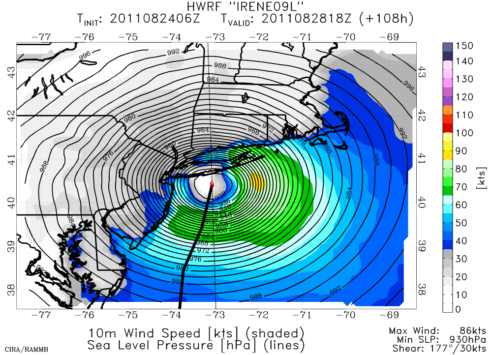
For some perspective on size, if you placed Irene's circulation over the continental US, it would cover Florida up to Pennsylvania, and from North Carolina to Oklahoma.  This is a large storm.

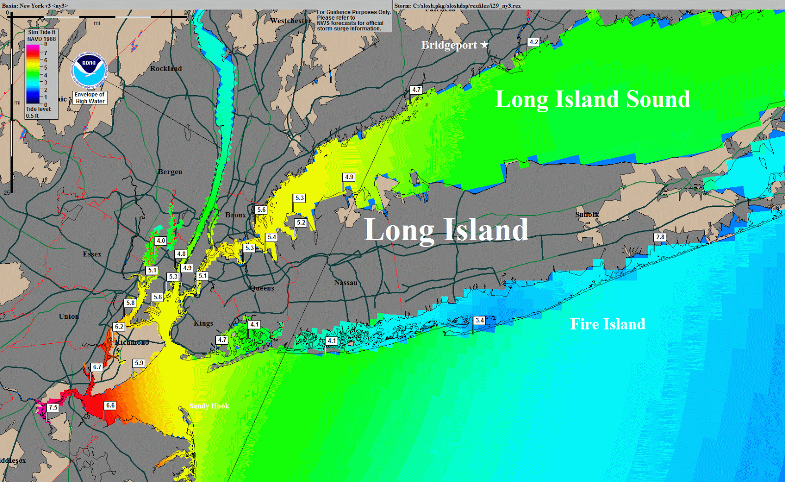
There are evacuations in coastal areas from NC up to MA, and wisely so.  Even if Irene continues to weaken, the storm surge and rainfall will be extremely destructive.  The storm surge is forecast to reach 8' in parts of the Chesapeake Bay, up to 6' in parts of the Delaware Bay, and 3-6' in the NJ/NY area.  The latest storm surge forecast for the NJ/NY area is shown below.  For the first time in history, New York City is shutting down its mass transit systems and evacuating low-lying portions of the city (300,000 people so far).


Looking back, I was able to find just 12 hurricanes in the past 160 years that had comparable tracks to Irene, many of them notable and infamous.  These include Floyd (1999), Bob (1991), Gloria (1985), Belle (1976), Donna (1960), Carol (1954), Edna (1954), and 5 from earlier years when storms weren't given names (1944, 1894, 1879, 1861, and 1858).  The plot below shows the east-central portion of the coast with these storms' tracks overlaid.  So Irene will be added to this list and be remembered just as these are.


Please visit my tropical Atlantic headquarters.

All eyes on Irene as it heads toward US coast

As of the latest advisory, Irene is heading N at 12kts with 90kt sustained winds.  It's about 330 miles S of Cape Hatteras NC.  The latest forecast track, watches, and warnings can be found at http://www.nhc.noaa.gov/storm_graphics/AT09/refresh/AL0911W+gif/092739W_sm.gif  The track is very ominous, and one of the worst-case scenarios for the entire northeast coast.  It's been 6 years since the US has experienced a major hurricane landfall, and that was Wilma when it hit just south of Naples FL with 105kt winds.  The last non-major (Cat 1-2) US hurricane landfalls occurred in 2008: Dolly, Gustav, and Ike (TX, LA, TX).


The first and strongest US landfall is expected in the early morning hours on Saturday, near Morehead City, NC, as a Category 2 (90kt) storm.  In addition to the powerful winds gusting up to 125mph, the storm surge will be quite high... up to 9' in surge-prone areas like Pamlico Sound.  Keep in mind that large violent waves are on top of that storm surge, and both are on top of the normal tides.

A long-range radar loop from Morehead City can be found here:
http://einstein.atmos.colostate.edu/~mcnoldy/tropics/irene11/Irene_26-27Aug11_MHXlong.gif
and a short-range radar loop can be found here:
http://einstein.atmos.colostate.edu/~mcnoldy/tropics/irene11/Irene_25-26Aug11_MHXshort.gif
Also, the exact time and location of landfall is almost irrelevant for a storm this large... the effects of the hurricane will be felt far from the center and for at least 12 hours before the eye crosses the coastline.

Further north and a day later, Irene will be just off of the NJ coast, and creating a large storm surge in the Chesapeake and Delaware Bays as well as along the ocean.  Norfolk VA is in a very sensitive area, and can expect a 6-7' surge.  It could still be a powerful Category 1 storm at that time, so wind gusts up to 120mph could affect coastal VA, MD, DE, and NJ.  There is still a lot of concern for New York City, where low-lying parts of the city exposed to water are home to large numbers of people.  Again, the evacuation map for NYC can be found here: http://www.nyc.gov/html/oem/downloads/pdf/hurricane_map_english.pdf

The image below shows what the latest forecast storm surge will be in the DE/MD/NJ/NY area:


Then on top of all of this is the rainfall.  The image here shows the 5-day forecast accumulated rainfall totals (in inches). Many areas in the northeast have just gotten a lot of rain unrelated to the hurricane, so the ground is saturated prior to getting up to a foot of additional rain.


Please visit my tropical Atlantic headquarters.

25 August 2011

Irene maintains Category 3 strength as it heads north

Since this morning, Irene has maintained its intensity at 100kts, but the latest aircraft flight into the storm found a central pressure of 948mb, indicating that Irene is intensifying a bit.

I have a long radar loop from Miami showing Irene's eyewall and western rainbands at http://einstein.atmos.colostate.edu/~mcnoldy/tropics/irene11/Irene_25-26Aug11_long.gif  Sometime tomorrow, the storm will be in range of the Morehead City NC radar... and the radar loop will be available at http://einstein.atmos.colostate.edu/~mcnoldy/tropics/irene11/Irene_26-27Aug11_MHXlong.gif

The latest forecast track, along with updated watches and warnings, is posted below.  This track is only shown out to 3 days... the 5-day track of course extends further to the north.

Many coastal cities have already begun their evacuations and preparations.  This is a very large and dangerous storm... do not be fooled by the exact category rating.  The storm surge all along the east coast could be quite large, even up into bays and sounds, but certainly along the ocean.  Mayor Bloomberg in New York City had the following to say about the situation:
"If the worst scenario is going to happen this weekend, we will activate other elements of our Coastal Storm Plan, including the possibility of evacuating of New Yorkers who live in low-lying areas that could be affected by such storm surges. That includes places such as Coney Island and Manhattan Beach in Brooklyn, Far Rockaway and Broad Channel in Queens, South Beach, Midland Beach, and other low-lying areas on Staten Island, and Battery Park City in Manhattan."


Please visit my tropical Atlantic headquarters.

Irene heading for US coast, TD10 forms

Major Hurricane Irene is wrapping up its destructive tour of the Bahamas, and has its eye on the eastern US coast now.  At 15Z today, the center of the storm was located very near Abaco Island in the Bahamas, and about 650 miles south of Cape Hatteras NC.  The intensity is 100kts (Cat 3, 951mb) and the heading is NNW at 11kts.  The structure got a little jumbled overnight, but appears to be reorganizing and intensifying now.  This is a very large storm, with tropical storm force winds extending an average of 170 miles from the center, and hurricane force winds extending an average of 49 miles from the center.  These will only increase with time.

The forecast track is becoming more and more certain thanks to large-scale troughs and ridges that are governing its motion in a very straightforward manner.  Select model tracks are plotted on Jonathan Vigh's website: http://www.ral.ucar.edu/guidance/realtime/plots/northatlantic/2011/al092011/track_late/aal09_2011082506_track_late.png
The official NHC forecast has a first landfall near Morehead City NC on Saturday morning as a Cat 3, then skimming along the coast, passing over the big northeast cities on Sunday morning-afternoon as a Cat 2 hurricane.  Hurricane watches are already posted for much of NC, evacuation of the Outer Banks is underway, and a state of emergency has already been declared for coastal NC.


On this track, and at this intensity, and with its large size, Irene has the potential to cause a lot of trouble from NC to ME.  "Trouble" refers to flooding rains, destructive winds, tornadoes, coastal erosion, and very large inundating storm surges.  Some prior hurricanes with similar tracks hitting Long Island are quite infamous: Carol (1954), Donna (1960), Belle (1976), and Gloria (1985).  The storm surge threat is very real with this storm, especially in big cities where many people are affected... Washington DC, Philadelphia, New York City, Boston, etc.  In addition, very heavy rain can be expected all along the track; this map to the right shows the 5-day forecast accumulation totals.  Given the enormous population and low elevation, New York City is a huge concern with a storm like this.  Finally, if you live anywhere along the east coast from NC on up to ME, pay close attention to the local news, make preparations well ahead of time, and evacuate if told to so.

Of much less significance now, TD10 formed this morning from the easterly wave I mentioned yesterday.  It is located at about 32W and is forecast track northwest and perhaps reach tropical storm intensity.  This does not look like it will be a storm of any concern to anyone, but the next name on the list is Jose.

Please visit my tropical Atlantic headquarters.

24 August 2011

Irene now a major hurricane

Irene continues to track slowly over the Bahamas, and is intensifying.  At 15Z today, it became the season's first major hurricane (Cat 3+), with an intensity of 100kts and a 956mb central pressure... that's a drop of 24mb in the past 24 hours.  A current satellite image (as of this writing) shows a well-defined eye centered over Acklins Island in the Bahamas.

Irene has also begun to turn toward the northwest, and the current motion is northwest at 10kts.  It is in an ideal environment for additional strengthening, and is forecast to reach 115kts (Cat 4) by Thursday morning.  The official track brings Irene over the remainder of the Bahamas through Thursday night, then heading a bit more north... perhaps scraping by coastal NC on Saturday.  More noteworthy however, is the track after that.  If the current model runs and official forecast verify, Irene will hit Long Island NY and/or coastal New England -- and still as a powerful hurricane.  One representative model run (HWRF) has an ominous forecast valid Sunday afternoon:


Aircraft are frequently flying into and around this storm to sample its structure and environment, hopefully resulting in accurate forecasts of intensity and track.  You can find the latest track forecast, watches, and warnings at http://www.nhc.noaa.gov/storm_graphics/AT09/refresh/AL0911W5+gif/143914W_sm.gif

Elsewhere, a very strong easterly wave exited Africa on Aug 22 and is now centered near 12N 28W.  It already has a vigorous mid-level circulation and is in a favorable environment for development.  However, the present steering currents out there are expected to lift this system northwestward long before it's a threat to any land.  If named, the next name is Jose.

Please visit my tropical Atlantic headquarters.

23 August 2011

Irene heading for Bahamas and possibly US

Since my last update on Friday (I apologize for the break during this interesting period... but it was vacation time), the easterly wave that was located far east of the Lesser Antilles has intensified dramatically.  It became TS Irene on Saturday evening, crossed over the Leeward Islands, became the season's first hurricane on Monday morning as it crossed over Puerto Rico, and is now nearing Category 2 intensity as it begins to track over the eastern Bahamas.


The forecast is of course of great interest to the US, since storms in this location can easily hit the US coast (either by tracking westward and entering the Gulf of Mexico or by recurving and hitting the southeastern states).  Models have been strongly trending toward an earlier recurvature, bringing any potential US landfall further and further northward along the coast.  The figure below (from http://rammb.cira.colostate.edu/products/tc_realtime/) shows three models' track forecasts... thick lines for past location, very thin lines for past forecasts (shown only once daily), and medium lines for the most recent forecast.  The feature to note is the older runs are consistently further west than the later runs.

The models are in good agreement for a NC landfall (or near miss offshore) on Saturday night, most likely as a Category 2-3 hurricane.  Before that though, it is causing and will continue to cause substantial problems in the Bahamas (wind, heavy rain, large storm surge, etc).  You can always find the latest official track forecast, watches, and warnings at http://www.nhc.noaa.gov/storm_graphics/AT09/refresh/AL0911W5+gif/205313W_sm.gif

The intensity at the latest advisory is 80kts with a forecast of 110kts in 3-4 days.

Please visit my tropical Atlantic headquarters.

19 August 2011

TD8 nearing Belize, central and eastern Atlantic disturbances brewing

At 03Z today, the easterly wave that we've been watching since it left Africa on Aug 10th was upgraded to TD8.  It's cruising along the northern coast of Honduras, and on the verge of becoming a Tropical Storm.  At 15Z, the intensity is 30kts and 1005mb.  It is expected to intensify just slightly prior to landfall in Belize on Saturday evening, and if named, it would be Harvey.  As time goes on (it's not in range as of this writing), you will be able to view a radar loop from Belize at http://einstein.atmos.colostate.edu/~mcnoldy/tropics/harvey11/Harvey_19-20Aug11.gif


The easterly wave that exited Africa on the 15th (AL97) is now near 50W, or roughly 700 miles east of the Lesser Antilles, and tracking west at about 15kts.  On its current track, it is expected to reach the Leeward Islands on Sunday morning, Puerto Rico on Monday morning, and then continuing toward Hispaniola, Cuba, and southern FL after that.  The majority of models do develop this to a TS, and some to a Cat 1 hurricane... the amount of land it encounters will be a large factor in determining just how strong it can get.

Finally, another easterly wave exited Africa yesterday (AL98) and is centered near 20W now... not even to the Cape Verde islands yet.  This vigorous wave was born over the Ethiopian Highlands back on Aug 12, traveled across Africa in one week, and is already showing signs of tropical development.  It's too early to say much about the potential track of this, but models are indicating more of a NW heading than W by five days out.


Please visit my tropical Atlantic headquarters.

18 August 2011

One disturbance nearing Central America, one in far eastern Atlantic

The easterly wave that we've been watching since it left the African coast back on Aug 10th is now located just 200 miles due east of the Honduras/Nicaragua border.  It is still not a Depression, but is visually very close (low-level winds appear to be circling in to it in all quadrants, and it has persistent centralized deep convection).  An aircraft is flying through the system as I type this, which will determine if it has reached TD or TS status.  It is forecast to continue its westward course, bringing it into Belize and the Yucatan Peninsula on Saturday... most likely as a Tropical Storm.  The next name on the list is Harvey.

Elsewhere, the easterly wave that exited Africa on the 14th is now centered near 40W (about 900 miles west of the Cape Verde islands).  This is a very large circulation, though lacking convection and organization.
Global forecast models indicate that this system will develop and be in the vicinity of Cuba and southern Florida by the middle of next week.  It's a long way out, but worth keeping a close eye on.  The following plot from Univ of Miami (http://www.rsmas.miami.edu/personal/smajumdar/predict/) shows the possible locations (from 20 members of the GEFS ensemble) of this disturbance next Thursday evening.  Keep in mind that this is only showing an indication of track, not intensity, and from one model.


Please visit my tropical Atlantic headquarters.

16 August 2011

Gert weakens, disturbance in Caribbean persists

As of this writing, Gert is not much more than a skeleton vortex... though still clinging to tropical storm intensity.  It is located approximately 550 miles south of Newfoundland and zipping off to the northeast at 26kts.  There is little to no deep convection associated with it, the SST under it is 26C and will decrease rapidly along its track, and it is soon going to get absorbed by a deep mid-latitude trough.  So, Gert's time as a TC is limited.  And with it not becoming a hurricane, this is the first time in 160 years of records that the Atlantic has started a season with 7 named storms and 0 hurricanes.

The disturbance that exited Africa on the 6th and was crossing the Lesser Antilles yesterday is now centered near 65W in the Caribbean (this was the one that can be traced back to the Ethiopian Highlands on Aug 2).  It's lacking a surface circulation, but it's persistent, and is still definitely worth keeping a close eye on.  Generally, models favor this system and intensify it quite substantially in the next 5 days as it heads W-WNW toward the Yucatan area.  BUT, it needs to at least become a Depression before getting concerned about anything beyond that.  An aircraft will investigate the system later today.


Elsewhere, a large easterly wave exited Africa early on the 15th and is now near the Cape Verde islands.  A scatterometer (a polar-orbiting satellite that can measure surface winds over the ocean) overpass earlier today reveals a fairly healthy low-level circulation... look near 12N 27W:


Please visit my tropical Atlantic headquarters.

15 August 2011

Franklin, Gert, and possibly Harvey...

During the weekend, the disturbance that was west of Bermuda (AL95) got slightly better organized and was upgraded to TD6 at 21Z on Friday.  Then at 09Z on Saturday, it was upgraded again TS Franklin, the sixth named storm of the season.  However, just 18 hours later, it has lost tropical characteristics and merged with a mid-latitude frontal system.  A short-lived and uneventful storm, like the rest of the storms in the Atlantic basin this season so far.

To add to that theme, Tropical Storm Gert is now churning east of Bermuda... this formed from the disturbance that I mentioned on Friday that was northeast of the Lesser Antilles (AL94).  The first advisory was written on this as TD7 at 03Z on the 14th.  The latest intensity is 50kts and 1000mb, and heading north at 10kts.  Some additional strengthening is still possible in the coming day or so before it too gets whisked away to the northern Atlantic TC graveyard.  Gert is the seventh named storm of the season, and if it does not become a hurricane in a hurry, this will be the first season in 160 years of records to have 7 named storms and 0 hurricanes.

Finally, AL93, the easterly wave that was near 30W on Friday, has continued its westward trek and is now near 58W... or about 200 miles east of the Lesser Antilles.  You can monitor its passage through the Lesser Antilles on radar: http://www.meteo.fr/temps/domtom/antilles/pack-public/animation/animMOSAIC2.html .  It's not too organized, but has had persistent convection since exiting Africa on the 10th.  This disturbance is strongly favored for intensification by the statistical models (SHIPS, LGEM, SHF5), but not so much by the dynamic models (CMC, GFS, NOGAPS, HWRF, GFDL).  If it does get named, the next name on the list is Harvey.


Please visit my tropical Atlantic headquarters.

12 August 2011

Multiple areas of interest scattered across Atlantic basin

Since Emily, the Atlantic has been fairly quiet, just some easterly waves trekking across the deep tropics, but for the most part, not developing into anything.
However, two such waves (one near 45W and one near 30W) are showing signs of gradual organization.  The one near 45W exited Africa on Aug 8, and the one near 30W exited Africa right on its heels on Aug 10.  There is also a potential for development with a Low located near Bermuda, and one northeast of the Lesser Antilles.

The visible satellite image from 1615Z today is shown below, with the four areas of interest circled in red.
At this point, none of these disturbances are even Depressions, and none pose a threat to land in the immediate future.   I will keep you posted though as any or all of these develop!  The next names on deck are Franklin, Gert, Harvey, and Irene.


Please visit my tropical Atlantic headquarters.

06 August 2011

Emily reforms just east of the southern Florida peninsula

The remnants of Emily finally acquired the organization required to be classified as a Depression, and at 21Z today, TD Emily was reborn.  The intensity is 25kts and 1012mb, and the heading is north at 7kts.  The center is located just offshore of Fort Lauderdale FL, but has been producing very heavy rainfall over the Bahamas for the past 24+ hours.  It appears that FL will escape the precipitation, perhaps with the exception of some isolated thunderstorms. 
The long-range radar loop from Miami can be found here: http://radar.weather.gov/radar.php?rid=AMX&product=N0Z&overlay=11101111&loop=yes and once Emily is further north, the loop from Melbourne will be more practical: http://radar.weather.gov/radar.php?product=N0Z&rid=mlb&loop=yes


Since the system did not "sneak under the westerlies", it lifted north and will continue to move north then northeast into the open ocean and come under the unfriendly influence of a mid-latitude front by Monday.  So its time as being "Emily" is limited once again.

Elsewhere, an easterly wave that exited the African coast back on July 30 is approaching the Lesser Antilles, at about 55W.  In addition, a new wave has just exited Africa and is near 17W... this can be traced back to the Ethiopian Highlands on Aug 2 and has a rather potent history as it trekked across the continent.


Please visit my tropical Atlantic headquarters.

05 August 2011

Can Emily make a comeback?

The remnants of Emily's low-level circulation have cleared Hispaniola and Cuba, and the "center" is now located just north of central Cuba's coast (south of Andros Island, Bahamas).  There is deep convection associated with the system, but it's displaced to the east.  I added a red X to the visible satellite image below to highlight where the surface circulation is located as of this writing since it's quite far from obvious.  I also added estimated locations over the past two days to give you an idea of where this ill-defined circulation has traveled.
In its current state, it's not very threatening... capable of some localized flash flooding at the worst.  But it is back over very warm water, and in a low-shear environment, so it's too early to completely let your guard down yet if you're in FL.  Models tend to not develop this system much anymore, since it needs to undergo genesis all over again.  Since this is not a deep coherent vortex, its motion isn't simply governed by the deep-layer mean flow; it could continue to sneak westward along the north coast of Cuba and enter the Gulf of Mexico.  Simple barotropic models (e.g. LBAR, BAMS, BAMM, BAMD) do actually bring the system south of FL and then recurve it back into the west coast of the FL peninsula in about 3 days.  However, the intensity should still be minimal, but FL can expect to get wet this weekend.  The long-range radar loop from Miami can be found here: http://radar.weather.gov/radar.php?rid=AMX&product=N0Z&overlay=11101111&loop=yes


Please visit my tropical Atlantic headquarters.

04 August 2011

Emily dissipates

The dry air and encounter with Hispaniola have overwhelmed the fragile circulation that Emily had, and the final advisory was written on the storm this afternoon.  The latest position estimate is between Cuba and Haiti and the heading is NW at 14kts.

Although the storm has weakened to an open trough, this does not rule out the possibility that it could regenerate once conditions improve.  Depending on the details how this happens, it could be classified as 6/Franklin or maintain 5/Emily.  To pull from a a 6-year old advisory written by Stacy Stewart at NHC:

THE NWS RULES GOVERNING THE NAMING OF TROPICAL CYCLONES SPECIFY THAT...WITHIN A BASIN...WHEN A CYCLONE FORMS FROM THE REMNANT OF A PREVIOUSLY EXISTING CYCLONE...THE OLD NAME/NUMBER IS RETAINED. TROPICAL DEPRESSION TWELVE HAS A COMPLEX GENESIS THAT LIKELY INCLUDES A MID-LEVEL REMNANT OF FORMER TROPICAL DEPRESSION TEN. A REVIEW OF SATELLITE AND RAWINSONDE DATA OVER THE PAST WEEK OR SO SUGGESTS THAT A SECOND DISTURBANCE APPROACHED AND COMBINED WITH THE MID-LEVEL REMNANT OF TROPICAL DEPRESSION TEN ON 20 AUGUST. BECAUSE IT IS IMPOSSIBLE TO DETERMINE WHICH OF THESE TWO SYSTEMS IS ASSOCIATED WITH TODAY'S GENESIS...WE HAVE ELECTED TO USE THE DESIGNATION TWELVE RATHER THAN TEN FOR THE NEW DEPRESSION. THIS SITUATION DIFFERS FROM LAST YEAR'S REGENERATION OF IVAN...IN WHICH THE LOW-LEVEL REMNANT OF THAT SYSTEM REMAINED A DISTINCT FEATURE THAT COULD BE FOLLOWED CONTINUOUSLY UNTIL IT REGENERATED.

So in this case from 2005, TD10 dissipated, and after careful analysis, the new circulation that formed from its remnants did not have enough of TD10 in its gene pool to keep the same name.  TD12 was classified as a new system from the remnants of TD10 (TD11 had formed elsewhere in the meantime).  Incidentally, TD12 would eventually hit southern FL as Tropical Storm Katrina and then the northern Gulf coast as Hurricane Katrina.

Many models do re-develop this storm, and the track passes over the Bahamas on Friday and Saturday, then recurving out to sea before reaching Florida.  The forecast intensity spread in 2 days (near closest approach to FL) is anywhere from 25-60kts for the models that re-develop it, and of course nothing for those that don't.


Please visit my tropical Atlantic headquarters.

03 August 2011

Emily falling apart as it approaches Hispaniola

Since getting named on Monday evening, Tropical Storm Emily has intensified slightly to 45kts, but has also been struggling to organize.  A combination of vertical shear and environmental dry air has hindered the storm from strengthening very much, which is certainly welcome news to the Dominican Republic and Haiti (the eastern and western nations of Hispaniola, for anyone who isn't familiar with it).  As of 15Z today, Emily was located about 120 miles south of Santo Domingo in the Dominican Republic and tracking W at 12kts.  As you can see in the satellite image, the low-level center (at about 17N 70.5W) is quite removed from the majority of the deep convection.

As it nears and traverses the mountainous island of Hispaniola, it will likely lose what structure it has, and undergo genesis again once it exits the island in about 24 h.  However, just because the storm isn't intense when measured in terms of wind speed, even tropical storms can be extremely dangerous to flood-prone areas due to large rainfall amounts... e.g. flash flooding, mudslides, etc.  The graphic below shows the latest 5-day forecast precipitation swath from the HWRF model (up to 24" over areas of Hispaniola with large amounts along the US coast from FL to NC later in the period):


In the longer range, models continue to indicate that Emily will graze or miss the US east coast, recurving very close to the coastline.  The current official forecast track as well as watches and warnings can be found here: http://www.nhc.noaa.gov/storm_graphics/AT05/refresh/AL0511W5_NL+gif/

Please visit my tropical Atlantic headquarters.

01 August 2011

Tropical Storm Emily becomes 5th named storm of the season

Based on extensive aircraft reconnaissance today, the disturbance near the Leeward Islands was upgraded to TS Emily.  The intensity is 35kts and 1006mb, and it's located 50 miles WSW of Dominica (the island between Guadeloupe and Martinique).  I have a radar loop available at http://einstein.atmos.colostate.edu/~mcnoldy/tropics/emily11/Emily_01-02Aug11.gif


There are tropical storm warning issued for the southern Leeward Islands, Puerto Rico, and Dominican Republic.  The latest watches and warnings can be found here: http://www.nhc.noaa.gov/storm_graphics/AT05/refresh/AL0511W5+gif/


The official forecast brings the storm over Hispaniola on Wednesday, the Bahamas on Thursday-Friday, and into south Florida on Saturday as a minimal hurricane.  As usual though, intensity forecasts are prone to errors, so this will be watched very closely, but the interaction with Hispaniola should limit the intensity.

Please visit my tropical Atlantic headquarters.

Disturbance nearing Lesser Antilles, poised to strengthen

The disturbance I mentioned in the July 29 update has gotten better organized over the weekend, though is just short of being classified as a Tropical Depression (as verified by an aircraft reconnaissance flight into it this morning).  It's been 8 days since this wave left the African continent, and now it's located about 250 miles east of Martinique in the Windward Islands, and tracking WNW at 12kts.  At this pace, it will cross the Leeward Islands on Tuesday morning, be near Puerto Rico on Wednesday morning, and near the Dominican Republic on Thursday morning. 


At this point, the bulk of models do not indicate that this storm will enter the Gulf of Mexico, but rather recurve before reaching the US coast, or make landfall somewhere along the east coast.  This far out, anyone in the Greater Antilles, Bahamas, and southeast US should be paying close attention.  The plot below from Jonathan Vigh shows the most recent series of model track forecasts, including models that range from very basic to very sophisticated and everything in between.


As far as intensity goes, it does not appear that there is an urgent risk of an intense hurricane in the next several days, so areas such as the Leeward Islands, Puerto Rico, and Hispaniola should be mostly concerned with the rain/flood threat it will bring.
If and when this system reaches Tropical Storm intensity (sustained winds of 35kts), it will be named Emily.

Please visit my tropical Atlantic headquarters.