The much-anticipated vertical shear has finally met Karen head-on. The low-level center is now displaced 3 degrees to the west of the deep convection and completely exposed, thanks to 25kts+ of westerly vertical wind shear (defined as the vector difference between the 850mb winds and the 200mb winds over the system). The intensity has fallen to 55kts and 1004mb. It's tracking WNW at 10kts, and the forecast is for heading NW and weakening/maintaining intensity. However, after this confrontation with the trough (5+ days) Karen could warrant a much more cautious watch as a ridge moves over the storm and decreases the shear and steers it more toward the west.
At 18Z today, TD13 was upgraded to TS Lorenzo based on aircraft recon into the storm. This is the twelfth named storm of the season, already above the long-term average of 10 for the season, and there are still 2 more months in the Atlantic hurricane season. Lorenzo has become much more compact, with a very vigorous central core and CDO with cloud tops hitting -80C.
The circulation is still visible from the Alvarado radar at http://smn.cna.gob.mx/radares/radares.html
The latest intensity is 50kts and 1004mb and it still appears to be intensifying. The forecast brings it up to 55kts prior to landfall on Friday night. The primary problem with this storm is the motion: almost none. It is drifting at 2-3kts toward the Mexican coast, and in the meantime will begin to spread very heavy rain throughout central Veracruz and even further inland.
There's a new healthy tropical wave near the Cape Verde Islands (~25W) which exited the African coast on Tuesday. Perhaps of more note is a wave still over land that should exit the coast tomorrow... that one is favored to develop quickly by several global models.
Please visit my tropical Atlantic headquarters.
27 September 2007
26 September 2007
Karen strengthening, TD13 forms...
Karen has made surprising strides in organization over the past 24 hours. A struggling 35kt storm yesterday at this time, it's now a compact 60kt storm with a developing eye... nearly a hurricane. It now has centralized deep convection, but the outflow is asymmetric owing to the westerly vertical shear. The estimated central pressure is 990mb, and Karen is now expected to reach hurricane strength later today. It's moving WNW at 11kts, and that motion should continue over the next several days, perhaps becoming more NW at times. The stronger vertical shear is still forecast to impinge on the storm late this week into the weekend, which could weaken it a bit, but by early next week, the trough will pass by and Karen might find itself on a strengthening trend again.
VIS satellite image of Karen: http://www.ssd.noaa.gov/goes/flt/t1/vis-l.jpg
The area of disturbed weather in the Gulf that I first mentioned on Monday has been upgraded to TD13, and is very close to being upgraded to TS Lorenzo. Intensity is 30kts and 1006mb and is forecast to drift very slowly toward the west into Mexico as a strong tropical storm on Friday. You can keep an eye on it from Alvarado's radar at http://smn.cna.gob.mx/radares/rad-alva.gif
The other area I was discussing before that was near Puerto Rico is now over the Dominican Republic: poorly organized and highly sheared. However, as I pointed out yesterday, this should not be dismissed in the long term. IF the circulation can survive the trip over Hispaniola, the hurricane "sweet spot" near the Bahamas could re-energize the system in a few days.
Lastly, a new area of interest has popped up off the southern Florida peninsula that warrants a close eye. It is in an environment conducive for genesis, and this could track across the peninsula as a VERY rainy tropical storm. If this does rapidly organize, the name/number on deck is 14/Melissa.
Radar image of this disturbance: http://radar.weather.gov/radar.php?rid=amx&product=N0Z&overlay=11101111&loop=no
Please visit my tropical Atlantic headquarters.
25 September 2007
Karen forms in deep tropics...
At 03Z today, the tropical wave near 35W was upgraded to TD12, then to Tropical Storm Karen just six hours later. It remains a minimal 35kt tropical storm now, and convection is fairly shallow and scattered. The vertical shear is very low right now, but is forecast to become excessive by the weekend, halting any attempts at a significant hurricane for the next several days. There is a buffer timeframe however, while the SSTs are warm and wind shear is low enough and before the subtropical jet comes in and kicks up the shear, when the storm could reach hurricane intensity (or after crossing north of the subtropical jet in a few days). It's located near 11N 40W and tracking WNW at 13kts.
Elsewhere, the other two areas of interest are still out there, but not in any rush to get organized. The one near 65W is entering a high westerly vertical shear zone near the northern Leeward Islands, and has a slim chance of making it through intact. BUT, if it does survive the next 2-3 days, it would be one for Floridians to monitor in case it develops near the Bahamas. And the third, now in the west-central Gulf of Mexico, is a 1009mb Low close to Depression status as it drifts very slowly to the west toward the Tampico area. It's over 30C SSTs, in a low-shear environment, and could become TD13 later today or tomorrow.
VIS image of system near northern Leeward Islands: http://www.ssd.noaa.gov/goes/flt/t2/vis-l.jpg
VIS image of system in western Gulf of Mexico: http://www.ssd.noaa.gov/goes/flt/t4/vis-l.jpg
Please visit my tropical Atlantic headquarters.
24 September 2007
Atlantic getting active...
Since my last message, Ingrid, TD10, and Jerry formed. Ingrid began on Sep 12 from an African easterly wave, and struggled against vertical shear and dry air for 5 days until degenerating to a low-level swirl then open wave near the Leeward Islands. TD10 was only around for a few hours on Friday and formed and dissipated near the western Florida panhandle.
Jerry formed this past weekend in the far north central Atlantic, first as a subtropical depression, then transitioned to a weak tropical storm, and is presently undergoing a transition to extratropical. None of the three systems were terribly noteworthy.
Now, there are several interesting items to discuss across the basin, each about 30 degrees apart.
First, there's a 1011mb Low in the southern Gulf of Mexico associated with a larger-scale trough. It's quite active, but strongly sheared. However, the shear is expected to lessen over the next day or two and perhaps allow this system to organize and drift westward toward Mexico. http://www.ssd.noaa.gov/goes/flt/t4/vis-l.jpg
A potent easterly wave that left Africa on Sep 16 has been convectively active the whole trip across the Atlantic, and today is no exception. It's crossing the Windward Islands now, and heading WNW toward Hispaniola. Conditions are favorable for continued strengthening. As it passed by Barbados earlier today, they recorded a pressure of 1009mb and winds of 18kts. You can monitor the passage of the wave from the Martinique/Guadeloupe radar at http://www.meteo.fr/temps/domtom/antilles/pack-public/animation/animMOSAIC2.html. The latest visible satellite image is at
http://www.ssd.noaa.gov/goes/flt/t2/vis-l.jpg
The most well-organized system is an easterly wave out by 9N 35W (exited African coast back on Sep 21). This is in an environment conducive to tropical cyclogenesis: SSTs of 28C and increasing along the future track, moderate vertical wind shear, and an embedded 1007mb Low. It is tracking WNW at 12kts. It should be able to gradually intensify; the only inhibiting factor is increasing shear as a trough nudges its way toward the system in the next few days. Depending on how close the two get, this could be a hurricane or suffer the same fate as Ingrid.
http://www.ssd.noaa.gov/goes/flt/t3/vis-l.jpg
Please visit my tropical Atlantic headquarters.
13 September 2007
TD9 becomes Humberto in a hurry, TD8 treks across deep tropics...
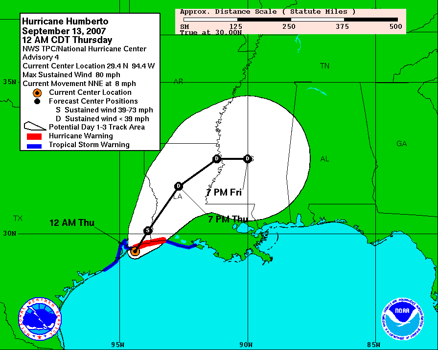
Well, Humberto was a surprise for everyone. There is not a forecaster I know of who would have called for a weak Depression to reach hurricane strength in less than a day and just miles offshore. Wednesday at 15Z, tropical storm warnings were posted for the areas near the newly-formed TD9 (http://www.nhc.noaa.gov/archive/2007/graphics/al09/AL092007_3W_001_0.GIF). The first hurricane warning was posted at 05Z on Thursday morning, just 2 hours before landfall, and without a hurricane watch ever being issued (http://www.nhc.noaa.gov/archive/2007/graphics/al09/AL092007_3W_004_0.GIF). It made landfall at about 07Z as a 75kt hurricane --10kts beyond minimal hurricane strength-- near High Island TX.
This intensification rate is astounding and unprecedented for a storm so close to land. Sustained winds went from 45kts to 75kts in just 18 hours, AND did so near the metropolitan area of Galveston/Houston. Rapid intensification is a challenge to predict, but when it's so close to land, a lot is at stake, and a wrong forecast can cost lives. So far in this storm, one death has been reported: a man outside watching the weather had a metal roof fall on him. It also doubtlessly affected some of the many unprepared oil refineries in that area.
There is a radar loop available at http://einstein.atmos.colostate.edu/~mcnoldy/tropics/humberto07/Humberto_12-13Sep07.gif which shows the whole evolution of Humberto... from weak tropical storm at about 1530Z Wednesday through a 75kt hurricane at 09Z Thursday and ending as a weakening hurricane over land at 13Z Thursday.
TD8 is still holding its ground as a depression, and struggling against hefty vertical wind shear. If and when the shear lets up even a little, all other conditions appear very favorable for it to intensify substantially. It should track a bit north of the Caribbean Sea, which leaves it in the southwest part of the basin by early next week, at which point, the US should a close eye on it. The next name on the list is Ingrid.
Please visit my tropical Atlantic headquarters.
12 September 2007
TD8 and TD9 form...
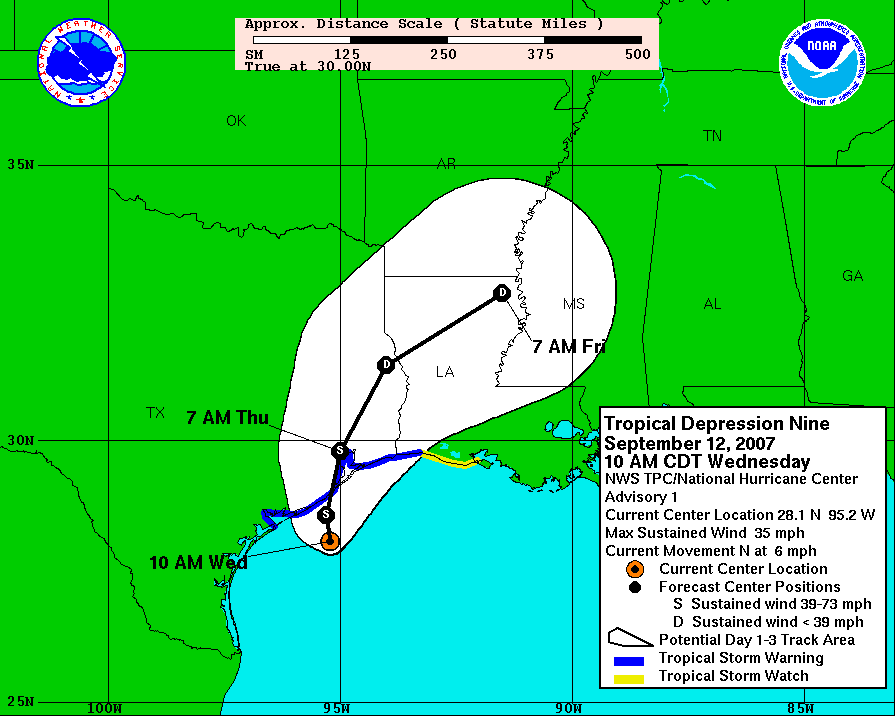
The African easterly wave I've been mentioning since Friday has finally been upgraded to a Depression. TD8 is now about 1100 miles east of the Lesser Antilles and tracking WNW at 10kts. The estimated intensity is 30kts and 1007mb. It is no immediate threat to any land... over the next 5 days it is forecast to slowly intensify and head WNW-NW, probably missing the Caribbean Sea, unlike Dean and Felix.
Also, an area of disturbed weather that has been meandering westward across the Gulf of Mexico for a few days was also upgraded to a Depression today. TD9 is now heading north and is just off the Texas coast, heading for Houston. It is very close to Tropical Storm intensity, and should be named before landfall later tonight. This could be a huge flooding problem for a very flood-prone metro area.
You can view a radar loop of TD9s approach into Houston at http://einstein.atmos.colostate.edu/~mcnoldy/tropics/humberto07/Humberto_12Sep07.gif
and data from a moored buoy near the mouth of Galveston Bay at
http://www.ndbc.noaa.gov/station_page.php?station=42035
Please visit my tropical Atlantic headquarters.
10 September 2007
Gabrielle forms and hits NC... another storm brewing in deep tropics...
On Wednesday and Friday of last week, I wrote about a potentially developing storm off the southeast coast of the US. On Friday night, it was upgraded to Sub-Tropical Storm Gabrielle and by Saturday afternoon had transitioned to Tropical Storm Gabrielle. It was heading west toward the coast as expected, and made landfall near Cape Lookout, NC midday Sunday as a 45kt tropical storm. It's since been downgraded to a Depression and is getting strongly sheared from the west. The remnant low-level circulation is located about 300 miles east of the DelMarVa peninsula and is being whisked northeastward by an encroaching trough.
Now, the primary area of concern shifts to a strong easterly wave tracking across the deep tropics, presently near 10N 40W.
It exited the African coast last Wednesday, and has been fairly slow to pull itself together. Satellite imagery reveals an anticyclone in place aloft, and a developing low- and mid- level cyclonic circulation. The latest sfc analysis shows a 1010mb Low with the wave. Given current appearance and trends, this could become TD8 later today. As far as its future is concerned, there appears to be little in its way to hinder further intensification, so another named storm is more or less expected out of it. The track could be influenced by a deep trough in the central Atlantic, allowing it to move a bit northward over the next few days, maybe giving the Caribbean nations a break. The next name on the list is Humberto.
Please visit my tropical Atlantic headquarters.
07 September 2007
Storm forming east of Georgia??
As I suggested in my last update on Wednesday, the US east coast should be on alert. Although not a named storm yet, the storm between the Bahamas and Bermuda has persisted through some rough times of strong vertical wind shear and is now beginning to show signs of organization. As the high pressure ridge to its north builds, not only will vertical shear lessen, the storm will also head west... toward the Carolinas. Should this get named, it would become Gabrielle. The future would take it generally W-NW, toward the Outer Banks of North Carolina during the weekend, possibly as a strong Tropical Storm or even a hurricane.
Another area of interest is near the Cape Verdes in the far eastern Atlantic. A potent easterly wave has exited the African coast and is favored by several reliable computer models to develop. Although these waves/disturbances can travel the entire width of the basin and hit the US or Mexico, this one (should it form) looks like it would recurve fairly far east due to a weakness in the subtropical ridge.
Also, you can follow along with tropical Atlantic activity on a blog run by the New York Times... I'm quite honored to be among such great company as Hugh Willoughby, Dave Nolan, and Bob Hartwig as co-contributors.
http://www.nytimes.com/2007/09/04/science/04hurricaneblog-web.html
There you'll find periodic updates from any or all 4 of us.
(If you're not already registered to view content at nytimes.com, registration is easy and free.)
Please visit my tropical Atlantic headquarters.
05 September 2007
Felix tears through Caribbean, US east coast on alert...
First of all, sorry for the lack of updates recently... I was on vacation and missed Felix completely. However, it was an amazing storm. Not only did it become the second hurricane of the season, it was also the second CAT5 hurricane of the season! It reached a peak intensity of 145kts and 929mb, which included an intensification rate of 26mb/6hr and 63mb/24hr. Another tidbit is that it went from a tropical storm to a CAT5 hurricane in 27 hours. This very rapid intensification was due to deep warm water (oceanic heat content) and very low vertical wind shear. It made landfall on the Nicaragua/Guatemala border on Tuesday morning as a 140kt CAT5 hurricane. Together with Dean, this marks the first time in recorded history that central America has been hit by two CAT5 storms in one year. It is still too early to comment on damage and fatalities, as reports have not yet made it out, and there is still a huge flood danger ahead.
Elsewhere, there's a subtropical circulation with a 1007mb central pressure in the northwestern Atlantic, about halfway between the Bahamas and Bermuda (29N 71W) that is presently quite sheared, but has also been gradually acquiring tropical characteristics. What's strange about it is the forecast track. Most storms in that location would be caught up in the mid-latitude westerlies and head out to the open ocean. BUT... a strong ridge is expected to build north of the system which could send it back west toward the US (Carolinas?) over the next few days, perhaps as a hurricane. A QuikSCAT (active microwave scatterometer that remotely senses ocean surface winds) overpass detected 25-30kt uncontaminated winds nearly wrapping around it. This could be upgraded to STS or TS Gabrielle within the next 24-36 hours.
Please visit my tropical Atlantic headquarters.
Subscribe to:
Posts (Atom)