28 June 2022

Bonnie is close to forming, warnings issued for southern Caribbean islands

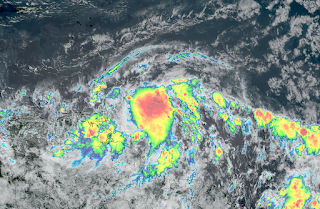
The tropical disturbance that I mentioned in Friday's update has gotten better organized, but is still not a tropical cyclone.  Although it contains tropical storm force winds, it's lacking a coherent circulation at the surface.  Once named, it would be Bonnie.


On Monday evening, the designation switched from Invest 94L to Potential Tropical Cyclone (PTC) Two.  This PTC nomenclature was introduced in 2017 (first used on June 18, 2017 for future-Bret), and has caused some confusion.  A PTC and an Invest are the same thing: an area of interest that has not yet become a tropical cyclone.  But, there are instances where an Invest is approaching land and is expected to develop within the next day or two, warranting the issuance of watches and/or warnings.  This was not possible using NHC's existing Invest framework, so the PTC framework was created.  Now, advisories, watches, and warnings can be issued for an Invest if needed using the PTC mechanism.  Think of it as a software hack rather than a change in the status of the storm system.  Prior to 2017, this exact same system would still be called Invest 94L.

It's cruising along very far south... it has not been above 10°N since it left the African coast last Tuesday.  This is expected to continue, and the forecast keeps it hugging the northern coasts of Venezuela and Colombia through the next three days then making landfall in Nicaragua or Costa Rica sometime around Saturday -- possibly as a hurricane.


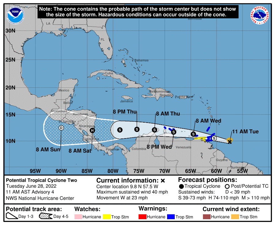
It will track directly over Trinidad on Tuesday night, most likely as a tropical storm.  Trinidad and Tobago rarely get hit by tropical storms; the last three were Gonzalo (2020), Bret (2017), and Joyce (2000).  They do get scraped by hurricanes passing by to the north now and then too.  Then, the ABCs (Aruba, Bonaire, Curacao) will experience some impacts from this on Wednesday into Thursday.  

It should be close enough to land to prevent much intensification.  However, there is a brief window of about 36 hours between Colombia and Nicaragua when it could strengthen and perhaps reach hurricane intensity.


There are long radar loops from Guyana and Barbados available at http://bmcnoldy.rsmas.miami.edu/tropics/radar/, and one from Curacao will be added shortly.  Unfortunately, the radar on Trinidad is down.

Elsewhere, the basin is stirring with an abnormal amount of activity for late June.  A disturbance tagged as Invest 95L is in the northern Gulf of Mexico, and then there's an easterly wave right on to the tail of PTC2.  Both have a low probability of becoming a tropical depression, but are worth watching.


NHC is giving the Gulf one (Invest 95L) a 30% probability of becoming at least a tropical depression by Thursday, but even if nothing happens with it, it will bring much-needed heavy rain into eastern Texas and southern Louisiana.  This map shows the forecast rainfall accumulations through the weekend.  Assuming PTC2 takes the name Bonnie, should this happen to become a tropical storm, the next name would be Colin.


24 June 2022

Africa is awakening early, again

A strong easterly wave left the African coast on Tuesday and has continued to show signs of organization since then.  As of Friday morning, it is centered near 30°W longitude, or about 2100 miles east of the southern Windward Islands.  The National Hurricane Center is giving it a 60% probability of becoming at least a tropical depression in the next five days. It could become a concern for the Caribbean in 5-10 days.  It is currently tagged as Invest 94L, but the next name on the list is Bonnie.


If you think it's awfully early to be looking to Africa for tropical cyclone development, you are exactly right! Last year, Elsa formed in the deep tropics from an African easterly wave on June 30, and in 2018, Beryl formed on July 4 in a similar location.  But it's quite rare to have a "successful" easterly wave so early in the season, so the odds are climatologically against this one making it.

However, ocean temperatures in that area are plenty warm to fuel its development... roughly 28°C -- and that will remain the case as it treks west-northwest.  I circled its approximate location on the map below for reference.  A rough rule of thumb is that tropical cyclones can develop and intensify with ocean temperatures of 26°C or above, and the warmer it is, the more energy they have to work with.


One of big reasons these African easterly waves don't usually start developing so early is large amounts of dry dusty air stream off the continent and cover the deep tropics for much of June and July, suppressing and choking off these nascent cyclones.  But this one is sneaking through at a really low latitude, so it's well south of the Saharan air (indicated by the orange and red shading here).


Models are in surprisingly good agreement on it developing, and on it continuing to track west-northwest for at least the next five days.  At this rate, it would reach the Windward Islands sometime around June 29, possibly as a tropical storm.  Beyond that, the uncertainty naturally increases substantially, but it should remain in the Caribbean for a few days.

Then as you can see in the two ensemble maps here (American above, European below), scenarios include a turn to the northwest or maintaining that west-northwest heading until it reaches Central America.  A notable number of ensemble members from both models bring it up to hurricane intensity in the longer range, so it's worth monitoring that trend.


Over the past fifty years, the average date of the second named storm formation is July 24, so if this develops, its location and date would be fairly typical in a month from now.

03 June 2022

Tropical Storm Alex is very close to forming and threatens south Florida


The long-anticipated redevelopment of former-Hurricane Agatha is close to happening -- Potential Tropical Cyclone 1 is now centered near the northwestern tip of the Yucatan peninsula and already has tropical storm force winds, it's just lacking a well-defined surface circulation.  Tropical storm warnings cover west Cuba, south Florida, and west Bahamas, but the primary concern is very heavy rainfall and flooding.


You can find long updating radar loops of PTC1 (future Alex) at http://bmcnoldy.rsmas.miami.edu/tropics/radar/

It is a sprawling and disorganized storm, with nearly all of the rain and thunderstorms displaced to the east of the surface circulation as a result of moderately strong westerly vertical wind shear.  However, even as a low-end tropical storm, it is still capable of producing very heavy rain with significant impacts.

The categorization of a tropical cyclone (tropical storm, Category 1 hurricane, etc) depends only on the peak sustained wind speed in the storm, and contains no information about the other hazards or even the size of the wind field.  A product that the National Weather Service has been creating operationally for every landfalling tropical cyclone since 2015 is called the "Hurricane Threats and Impacts" (HTI) graphics.  These display the four hazards associated with tropical cyclones (wind, rain, storm surge, and tornadoes) on an interactive map using a four-tiered threat scale.  The latest for south Florida is shown below, but you can also find them at https://www.weather.gov/srh/tropical.


In south Florida, the heaviest rain and strongest winds are expected to occur from the early morning hours on Saturday through midday Saturday, but conditions will gradually deteriorate/improve before/after then.  At their strongest, winds could creep into low-end tropical storm force (sustained 40-45 mph with higher gusts), particularly along the immediate coastline. In low-lying areas, the tide cycle can make a difference in how well storm drains function, and on Saturday the high tides are at approximately 1am and 1pm, so heavy rain in the hours around then could be especially problematic.  The western part of south Florida could experience minor storm surge flooding.

Once named, Alex will be the first named storm of the season, and will be the latest first named storm since 2014!  Over the past fifty years (1973-2022), the median date of first named storm is June 19th, but there is definitely a trend to earlier in the year.
After Florida, PTC1 (Alex) is expected to strengthen some more, but remain over the water.  However, it could bring heavy surf to the southeast US coastline, and have some impacts on Bermuda on Monday as it transitions to an extratropical cyclone.