30 August 2015

Tropical Storm Fred forms just off African coast

Early Sunday morning, Tropical Storm Fred formed from an easterly wave almost immediately after exiting the African coast.  In fact, the Cape Verde Islands have a tropical storm warning and a hurricane watch.. an extremely rare event.


Fred is the second farthest east tropical storm formation in the records (back to 1851).  If we look at all known tropical cyclones (which includes Depressions) that formed east of 19°W, there have only been 20.  Fred was named at 18.4°W (in the best-track), and the only one further east was Ginger 1967 at 18.1°W.  Note that two Florida landfalling storms had their origins this far east: Dora 1964 (Category 3 landfall near St. Augustine) and the 1928 Okeechobee Hurricane (Category 4 landfall near West Palm Beach).  Just for reference, the travel time from the coast of Africa to south Florida is approximately 10-12 days for an average easterly wave.

Tracks of all known tropical cyclones that formed east of 19W.  Of the 20 on this map, only three went on to become hurricanes, and two of those became major hurricanes.
While dry air ahead of it could limit the long-term intensity, it is forecast to become a strong tropical storm, and could easily reach hurricane status in the next couple of days as it heads west-northwest.  It will pass over the Cape Verde Islands on Monday.


24 August 2015

Danny dissipates, soon-to-be-Erika following close behind

Danny finally succumbed to the harsh environment it was in just as it reached the Leeward Islands.  The National Hurricane Center wrote its final advisory on Danny at 11am EDT today, and regeneration is not expected as the remnants drift west into the Caribbean.

The remnants of Danny crossing into the eastern Caribbean.  The Leeward Islands can still expect scattered rain showers and gusty wind. (NOAA)
The easterly wave that I first mentioned in Saturday's post has indeed continued to develop, and is designated 98L for now.  It could be upgraded to Tropical Depression Five or Tropical Storm Erika very soon.  It formed over eastern Africa around August 16, and entered the Atlantic on August 20.  98L is located about 950 miles east of the Leeward Islands as is moving to the west at a brisk 20mph.

Large-scale enhanced infrared satellite view of the deep tropical Atlantic... with the remnants of Danny and the Lesser Antilles on the left, and 98L on the right.
Zoomed-in view of 98L.
The environment has not changed too drastically since Danny's trek last week, but even Danny was able to briefly attain Category 3 intensity!  The latest ensemble of the global GFS model shows two general scenarios: the system remains weaker and tracks more toward the west, or it gets stronger and is more prone to recurve before even reaching the Leeward Islands.  I advise against looking specifically at any single track here... it's just a single run from one model's ensemble.  The idea is to just show patterns and trends.  The tracks are color-coded by the intensity on this map.
This storm is moving twice as fast as Danny was, so even in its current location, it should reach the general area of the Leewards by Thursday. 


23 August 2015

Danny weakens further to tropical storm, will reach Leewards on Monday

The strong vertical wind shear that began to affect Danny on Friday afternoon has continued and is even stronger now.  This was anticipated, as was the weakening back down to a tropical storm.  Further weakening is expected.

Sunrise over Tropical Storm Danny.
As of the 5am EDT advisory, Danny's peak winds are down to 50mph.  It is moving west at 15mph, which would bring it to the Leewards by Monday morning.  As such, there are tropical storm watches and warnings in place for parts of the Leeward Islands.


The track forecasts, shown in a similar fashion to yesterday, have not changed much.  There are more members showing a path into the Caribbean, which in this case means Danny is weaker and being steered more by the low-level trade winds, according to those models. 

Model guidance and official forecast with cone of uncertainty as of Sunday morning.
The National Hurricane Center is forecasting Danny to be dissipated in five days, by the time it reaches eastern Cuba.  While most models agree with the weakening trend, one labeled GFNI (a regional dynamical model) most definitely does not!  In the track map above, that is the track that recurves sharply to the north.

Elsewhere, the easterly wave behind Danny (right off the African coast) is also likely to develop in the coming days.  It is moving quickly to the west, and could reach the Leeward Islands region by Friday, so I'll watch it closely.  The next name on the list is Erika.

Enhanced infrared satellite image over "98L".
NOTE: I probably won't write an update on Monday (vacation), but you can get the latest track forecasts, watches, and warning from the NHC website.  Thanks!


22 August 2015

Dry air and shear affecting Hurricane Danny

After yesterday's nearly flawless appearance on satellite images, Danny is now showing signs of a more hostile environment.  The micro-hurricane is surrounded by dry air, and is entering a belt of strong vertical wind shear.  The combination is expected to significantly weaken the storm over the next few days.  As of the 5am EDT NHC advisory, Danny's peak winds are down to 100mph from a peak of 115mph yesterday afternoon.

Enhanced water vapor image over the central Atlantic from 6:45am EDT today.  Warm colors indicate dry air in the mid-upper levels of the atmosphere.  The sloppy asymmetric cloud shield over Danny is evidence of wind shear. (NASA)
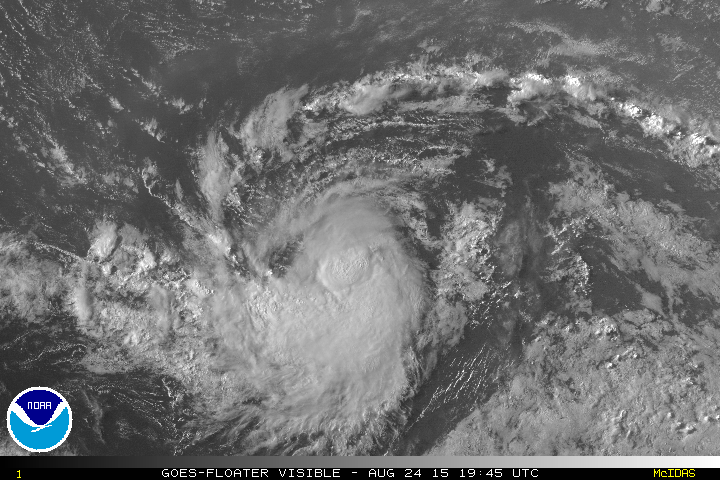
In a zoomed in visible satellite image, you can actually see Danny's cloud tops getting whisked away to the northeast, and the surface circulation is centered to the southwest of the thunderstorm activity. 


The track forecasts have not changed much at all, and a selection of dynamical model forecast tracks is shown below in addition to the NHC forecast (OFCL) and cone of uncertainty.  It is forecast to be near the Windward Islands and Puerto Rico on Monday --likely as a tropical storm-- and then most of the guidance is along or north of the Greater Antilles, which at first glance, looks quite threatening for the Bahamas and south Florida. 


However, if we look at the intensity associated with those tracks, we see that Danny is forecast to be much weaker in 5 days.  The GFDL suite of models (GFTI/GFDI/GHMI on here) offers an exception: the storm weakens over the next few days but then is able to regroup and reintensify over the Bahamas. 
Intensity guidance as of Saturday morning.  In 5 days, the range spans from a tropical depression to a Category 2 hurricane.
That scenario can't be ruled out, but the majority of models currently do not suggest that right now.  I've gotten a lot of questions from south Floridians about this storm, and as of now, there is no cause for concern... just cause for attention.  It's still about 2,000 miles away from south Florida, but *IF* it remains intact and *IF* it continues to track toward the area, it would arrive in the Friday timeframe.

Here is an interesting graphic that I produce... it's a week-long series of slices of infrared satellite images over the tropical Atlantic, with a slice every 12 hours.  The newest image is on top, and the oldest is on the bottom and is from August 14 when the wave that would become Danny left the African coast.  I tracked Danny with a red line.  These African easterly waves are a normal and regular feature of the tropical Atlantic from late July through October, and a small fraction of them end up becoming named storms and even major hurricanes.

Which leads me to the next potential system... a wave that exited the African coast yesterday.  More on that later if it shows signs of development.


21 August 2015

Afternoon update on Major Hurricane Danny

An aircraft reconnaissance mission into Danny on Friday afternoon found winds that supported upgrading it to a Category 3 storm.  As such, at 2pm EDT, the National Hurricane Center issued a special bulletin... the maximum sustained winds were set to 115mph, with a 974mb central pressure.  A major hurricane is a Category 3+ storm.


Danny is the first major hurricane of the season... the climatological date of first major hurricane formation is September 4.
The last Atlantic major hurricane was Gonzalo in October 2014, and the last major hurricane to form this far south was Fred in September 2009.

Danny is still forecast to encounter hostile environmental conditions this weekend.  For the latest updates, forecasts, watches, and warnings, please check the National Hurricane Center website.


Hurricane Danny strengthens into Category 2 as it spins toward the Caribbean

Friday morning update on Hurricane Danny...


Hurricane Danny strengthens into Category 2 as it spins toward the Caribbean


18 August 2015

Tropical Depression Four has formed in the Atlantic, tracking toward Caribbean

11am UPDATE: The disturbance has been upgraded to Tropical Depression 4.

The disturbance in the central Atlantic has gotten better organized... please read the full update on the Capital Weather Gang blog at:

Tropical Depression Four has formed in the Atlantic, tracking toward Caribbean